What a Detroit Border Drone Rollout Reveals About High
What a Detroit Border Drone Rollout Reveals About High-Altitude Inspection Planning with the Matrice 400
META: A field-driven Matrice 400 case study for high-altitude construction inspection, drawing lessons from Birdstop’s Detroit trucking hub deployment, real-time visibility demands, antenna positioning, transmission discipline, and mission planning.
When a drone program goes live at a logistics choke point, the aircraft matters less than the workflow it can sustain.
That is why the recent Birdstop deployment in Detroit caught my attention. On May 6, 2026, the Michigan-based company announced drone monitoring across trucking sites in Detroit using its Fealty system, with Detroit-based TSPS as its local partner. The headline detail was not glamorous, but it was operationally sharp: real-time visibility into truck parking at the U.S.-Canada border.
If you inspect construction sites at high altitude, that should sound familiar.
Not because truck parking and mountain construction are the same job. They are not. But both environments punish latency, weak communications discipline, and casual flight planning. When your client needs current situational awareness rather than pretty footage, the standard shifts. You are no longer just flying a drone. You are maintaining a live information pipeline.
That is exactly where a Matrice 400-class platform earns its keep.
The real lesson from Detroit: visibility beats image collection
Most drone articles fixate on sensors first. In practice, commercial operators usually fail somewhere earlier in the chain.
Birdstop’s Detroit rollout centered on “real-time visibility.” That phrase matters. It implies the mission objective was not merely to capture data and review it later. The objective was to provide live understanding of site conditions around truck parking near the border, where congestion, turnover, and access conditions can change quickly.
For a high-altitude construction team, the same logic applies when monitoring:
- laydown yard congestion
- access road status
- crane movement windows
- material staging
- slope stability indicators
- temporary structure progress
- thermal anomalies on installed systems
A Matrice 400 used for this kind of work should be configured around decision speed, not just payload capability. That changes how you think about transmission, antenna orientation, battery handling, and even how you build your flight lines for photogrammetry.
If your aircraft gathers perfect data but the site superintendent gets it too late to act, your mission underperformed.
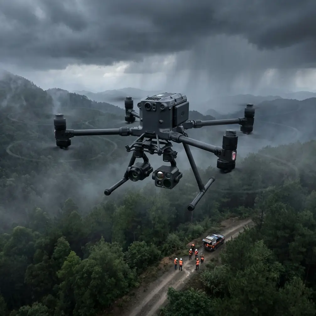
Why the Matrice 400 fits this inspection profile
For high-altitude construction inspections, the Matrice 400 conversation should start with resilience. Thin air, terrain masking, shifting weather, and intermittent line-of-sight all strain an operation in ways flatland demo flights never reveal.
What makes a heavy-duty enterprise platform useful here is not one isolated feature. It is the stack:
- stable long-range link behavior through O3-class transmission architecture
- encrypted data handling with AES-256 for sensitive project information
- hot-swap batteries that reduce downtime during narrow weather windows
- support for thermal and visual workflows in one program
- enough platform stability for repeatable photogrammetry tied to GCP-based control
Those features are often described separately. In the field, they function as one system. That system either supports continuity or it creates friction.
The Birdstop example is a good reminder that continuity is the real product.
Case study lens: adapting a border-monitoring mindset to alpine construction
Let’s take the Detroit trucking deployment as a model and translate its underlying operational principles into a high-altitude Matrice 400 inspection scenario.
Imagine a contractor building a transport interchange at elevation. The site includes retaining structures, temporary haul roads, prefabricated steel sections, and utility runs crossing uneven ground. Winds accelerate through the valley after noon. Snowmelt changes surface reflectivity by the hour. Ground teams are spread across multiple terraces, and radio comms are inconsistent in some pockets.
The client asks for three things:
- live aerial overwatch during active work windows
- weekly photogrammetry outputs for progress verification
- thermal signature checks on electrical and mechanical installations before handover phases
That combination is more demanding than it looks. Live visibility wants immediacy. Photogrammetry wants repeatability. Thermal inspection wants environmental discipline. The Matrice 400 can support all three, but only if the operator thinks like a systems manager rather than a pilot with a camera.
Detroit offers the pattern: use the drone to create current operational awareness first, then build the data products around that spine.
Antenna positioning advice for maximum range
This is where many teams leave performance on the table.
If you are flying a Matrice 400 on a high-altitude construction site, antenna positioning is not a trivial habit. It directly affects link reliability, video stability, and the confidence to hold safe stand-off distances from terrain or structures.
My field rule is simple: do not point the antenna tips at the aircraft. Present the broad side of the antenna pattern toward the drone’s expected operating sector. In mountainous or stepped construction environments, that often means adjusting your controller posture as the aircraft gains altitude or moves laterally across ridgelines, instead of freezing in one comfortable stance.
A few practical habits matter:
- Stand where the controller has the clearest sky view to the aircraft’s working area, not where your vehicle is parked.
- Avoid setting up directly below steel framing, tower cranes, or temporary roof canopies that can scatter or block signal.
- If the mission involves traversing one slope face to another, rotate your body and controller with the flight path rather than letting the aircraft drift into an off-axis signal angle.
- Elevation changes trick operators into thinking they always have line-of-sight. Visual sight is not the same as clean RF geometry.
- When working near site offices, generators, and communications trailers, add buffer distance. Interference is often local and self-inflicted.
This is one of the strongest links between the Detroit border use case and construction inspection. A system meant to provide real-time visibility only works when transmission discipline is treated as part of flight operations, not as a technical footnote.
Why hot-swap batteries matter more at altitude than most teams admit
On paper, hot-swap batteries sound like a convenience feature.
At altitude, they are a scheduling feature.
Construction inspections in mountain or plateau conditions are often squeezed into narrow windows: before convective winds build, before glare ruins thermal contrast, or before crews occupy critical areas. If you have to power down fully and lose workflow momentum between sorties, small delays accumulate fast. Ground teams move. Shadows change. Equipment relocates. Your comparison set degrades.
A hot-swap routine helps preserve mission continuity across repeated flights. That matters in two specific ways.
First, live site monitoring remains consistent. If your client is using the feed to manage active logistics, reduced downtime keeps the drone useful as an operational tool rather than a stop-start observer.
Second, photogrammetry quality improves because your relaunch sequence becomes cleaner. You can maintain better pacing between overlap-critical passes while preserving the same ground control structure. On steep sites where GCP placement already takes effort, anything that reduces mission interruption has real value.
Thermal signature work: don’t let the image fool you
High-altitude environments produce beautiful thermal imagery and misleading thermal imagery, often on the same day.
A Matrice 400 used for thermal signature inspection on a construction project can help identify insulation defects, overheated electrical terminations, moisture patterns, and uneven equipment loading. But thermal interpretation becomes unreliable if you ignore timing, wind exposure, and material heat soak.
The Detroit story again points us in the right direction. The point of the mission was situational visibility, not decorative data. Thermal flights should be treated the same way. Fly for actionable contrast.
That usually means:
- avoiding periods when direct solar loading overwhelms subtle anomalies
- comparing similar surfaces under similar exposure conditions
- documenting wind conditions because convective cooling can hide developing issues
- aligning thermal captures with visible-light context and site notes from ground teams
A thermal map without operational context is easy to misread. A thermal map tied to construction sequencing becomes useful.
Photogrammetry, GCPs, and the hidden value of repeatability
Many readers looking at the Matrice 400 for construction work are balancing live oversight with progress mapping. That is where photogrammetry discipline separates credible documentation from pretty models.
If your site is at high altitude, terrain variation amplifies geometry problems. You cannot assume a generic grid mission will produce clean outputs over cut slopes, stepped excavations, and partially enclosed structures. Ground control points matter, and so does consistency in how you revisit them.
I recommend treating GCP planning as a site logistics task, not a post-processing task. Place control where it survives traffic, weather, and changing work fronts. Maintain a clear record of which points remain valid between survey cycles. If your client compares week-to-week volume changes or structural progress, drift in control strategy can quietly undermine confidence in the whole program.
This is another operational echo of the reference material. Birdstop’s Detroit deployment was built around a repeat service across multiple trucking sites, not a one-off flight. The significance there is scale through consistency. For Matrice 400 construction inspection, the same principle applies: repeatable mission design is what turns drone output into a management instrument.
Data security is not abstract on active projects
The inclusion of AES-256 in the Matrice 400 discussion is not checkbox language. It matters because high-value construction projects generate sensitive visual records: access layouts, subcontractor sequencing, utility routes, defect logs, and progress status before public release.
At a remote high-altitude site, data often travels through field tablets, temporary office networks, and removable media under less-than-ideal conditions. A platform and workflow that support strong encryption reduce the chance that drone operations become the weak link in project information handling.
This is especially relevant when the drone feed is used for real-time management decisions, as seen in the Detroit border monitoring example. Once aerial data becomes operationally live, its sensitivity rises. It is no longer just documentation. It is current site intelligence.
What aircraft design teaches drone operators about inspection margins
One of the less obvious references in the source material comes from civil aircraft design guidance discussing relative positioning between major components and the need to verify engine nacelle ground clearance and landing gear parameters. On the surface, that has nothing to do with a Matrice 400 on a construction site.
Look closer, and the operational lesson is excellent: geometry creates safety margins.
In aircraft design, changing one relative position affects clearance, stability, and overall performance. In drone inspection, the same mindset should guide how you plan launch points, obstacle offsets, and terrain separation. High-altitude construction sites are full of geometry traps—temporary fencing, protruding rebar, cranes, cable runs, and slope breaks that distort depth perception.
The takeaway is not academic. It is practical. Respect relative positioning. Build your mission around clearances before you think about image aesthetics.
The second technical reference, focused on damage tolerance and iterative crack-length assessment, offers another useful parallel. The text describes a repeated process of assuming a crack form and length, testing whether it has reached a critical condition, and iterating if it has not. For drone operators, this is a strong model for inspection planning itself: do not assume one pass reveals the true condition. Reassess, refine, and revisit until the observed feature crosses a meaningful threshold for action.
That is how experienced inspection teams work. They do not confuse first detection with final diagnosis.
A better way to frame Matrice 400 value on high-altitude sites
The strongest argument for the Matrice 400 in this setting is not that it flies farther or carries more. It is that it supports a professional inspection rhythm:
- live oversight when site conditions are changing
- controlled thermal work when hidden faults matter
- repeatable photogrammetry when progress must be defensible
- secure handling when project data is sensitive
- battery continuity when weather and labor windows are tight
If you want to compare deployment concepts or discuss field setup details, you can message our drone team here.
That rhythm is what turns a drone from an airborne camera into an inspection system.
And that, ultimately, is why the Detroit Birdstop launch matters beyond trucking. A real-world rollout at border-adjacent logistics sites highlights the same truth high-altitude construction teams live with every day: aerial operations only become valuable when information arrives in time, reliably, and in a form people can act on.
For Matrice 400 operators, the mission is not simply to fly well. It is to preserve clarity between the aircraft, the data link, the site team, and the decision that follows.
Ready for your own Matrice 400? Contact our team for expert consultation.