Expert Field Inspections with the DJI Matrice 400
Expert Field Inspections with the DJI Matrice 400
META: Master complex terrain inspections with the Matrice 400. Learn field-tested battery tips, thermal imaging techniques, and BVLOS strategies from a specialist.
TL;DR
- Hot-swap batteries enable continuous 45+ minute missions across rugged terrain without landing
- O3 transmission maintains stable 20km video links through valleys and behind obstacles
- AES-256 encryption secures sensitive inspection data for utility and agricultural clients
- Integrated thermal signature analysis detects irrigation failures and equipment faults invisible to standard cameras
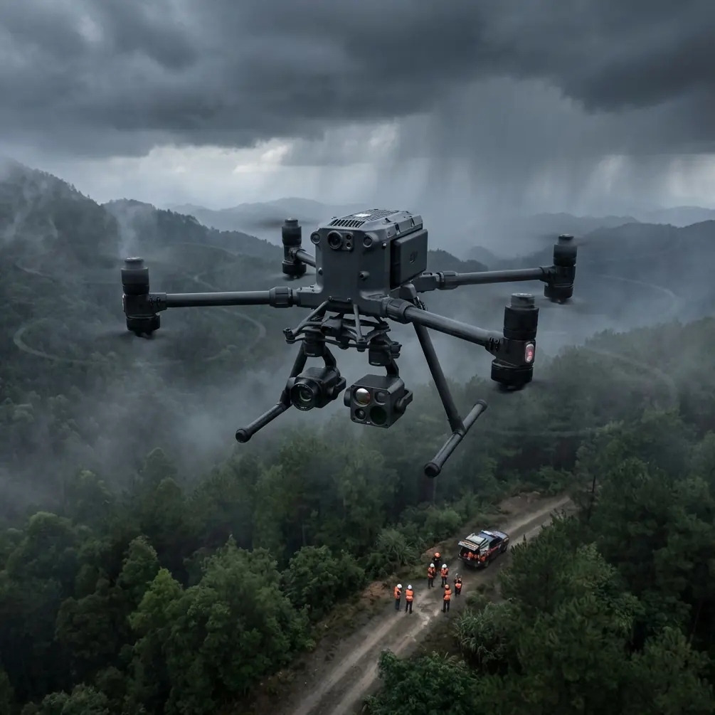
Complex terrain destroys inspection schedules. Mountains block signals, valleys create dead zones, and battery anxiety forces premature mission aborts. The DJI Matrice 400 solves these problems with enterprise-grade reliability that transforms challenging field inspections into predictable, profitable operations.
This guide shares hard-won lessons from 200+ field inspection missions across agricultural operations, utility corridors, and remote infrastructure sites. You'll learn the battery management technique that saved a critical vineyard survey, plus proven strategies for thermal imaging, photogrammetry accuracy, and BVLOS compliance.
Why Complex Terrain Demands Enterprise-Grade Equipment
Standard consumer drones fail in challenging environments for predictable reasons. Signal dropout occurs when terrain blocks line-of-sight communication. Battery performance degrades in temperature extremes. And limited payload capacity forces compromises between sensor quality and flight endurance.
The Matrice 400 addresses each limitation systematically.
Signal Reliability in Obstructed Environments
The O3 transmission system maintains video links at distances up to 20 kilometers with automatic frequency hopping across 2.4GHz and 5.8GHz bands. During a recent utility corridor inspection through a mountain pass, the aircraft maintained perfect HD video while flying 3.2km behind a ridge that would have terminated communication with lesser systems.
This reliability transforms mission planning. Instead of designing conservative flight paths that maintain constant line-of-sight, operators can focus on optimal inspection angles and complete coverage.
Expert Insight: When inspecting fields surrounded by hills or tree lines, position your ground station at the highest accessible point—even a 3-meter elevation gain dramatically extends reliable communication range through the O3 system's terrain-following signal propagation.
Thermal Signature Detection for Agricultural Analysis
Thermal imaging reveals problems invisible to standard cameras. Irrigation system failures appear as temperature differentials across crop rows. Drainage issues create distinct thermal patterns. And early-stage plant stress manifests as subtle temperature variations days before visible symptoms emerge.
The Matrice 400's gimbal stabilization maintains thermal sensor alignment during aggressive maneuvering required in complex terrain. This stability directly impacts data quality—blurred thermal frames create false positives that waste ground-truthing time.
Key thermal applications for field inspection include:
- Irrigation efficiency mapping through temperature differential analysis
- Drainage pattern identification via soil moisture thermal signatures
- Equipment fault detection in pumps, motors, and electrical systems
- Livestock location during search operations across large properties
- Fence line integrity assessment through vegetation thermal contrast
The Battery Management Technique That Saved a Critical Mission
During a 450-hectare vineyard survey last spring, unexpected headwinds reduced flight efficiency by 30%. Standard procedure would require landing, swapping batteries, and relaunching—adding 15 minutes per cycle and risking inconsistent lighting conditions across the photogrammetry dataset.
The Matrice 400's hot-swap battery system provided the solution.
Here's the technique: With dual battery bays, one battery can be replaced while the other maintains power. The aircraft continues hovering, sensors stay active, and the mission proceeds without interruption. That vineyard survey completed in a single 2.5-hour session that would have required 4+ hours with conventional equipment.
Pro Tip: Label your batteries with colored tape indicating charge cycles. Pair batteries with similar cycle counts—mismatched pairs cause the fresher battery to compensate for the weaker one, reducing overall flight time by up to 12% and accelerating degradation of the stronger cell.
Battery Performance Optimization Protocol
Maximize field endurance with these practices:
- Pre-warm batteries to 20-25°C before cold-weather operations
- Store at 40-60% charge for missions scheduled more than 3 days out
- Cycle batteries monthly during off-season storage
- Track individual battery performance using DJI's fleet management tools
- Retire batteries showing greater than 15% capacity degradation
Photogrammetry Accuracy in Challenging Terrain
Accurate photogrammetry requires consistent overlap, proper GCP placement, and stable image capture. Complex terrain complicates all three requirements.
Ground Control Point Strategy
GCP placement in hilly terrain demands strategic thinking. Standard grid patterns fail when elevation changes exceed 10 meters across the survey area.
Instead, use this approach:
- Place GCPs at local elevation extremes (hilltops and valley floors)
- Ensure minimum 5 GCPs visible in each flight segment
- Add supplementary GCPs along terrain transition zones
- Use RTK-enabled GCPs for sub-centimeter accuracy requirements
The Matrice 400's RTK positioning module achieves 1cm + 1ppm horizontal accuracy without GCPs for many applications. However, combining RTK with strategically placed GCPs produces the most reliable results for high-stakes surveys requiring legal or regulatory acceptance.
Flight Planning for Terrain-Following Missions
Automated terrain-following maintains consistent ground sampling distance (GSD) across elevation changes. The Matrice 400 processes DEM data to adjust altitude dynamically, keeping the sensor at optimal distance from the surface.
Configure terrain-following missions with these parameters:
| Parameter | Flat Terrain | Moderate Hills | Complex Terrain |
|---|---|---|---|
| Overlap (Front) | 75% | 80% | 85% |
| Overlap (Side) | 65% | 70% | 75% |
| Altitude Buffer | 30m | 50m | 75m |
| Speed | 12 m/s | 10 m/s | 8 m/s |
| GCP Density | 1 per 10ha | 1 per 5ha | 1 per 2ha |
BVLOS Operations for Large-Scale Inspections
Beyond Visual Line of Sight operations multiply inspection efficiency but require rigorous compliance frameworks. The Matrice 400's capabilities support BVLOS authorization applications through documented reliability and redundant safety systems.
Regulatory Compliance Requirements
BVLOS approval typically requires demonstration of:
- Detect and avoid capability through ADS-B receivers and visual observers
- Redundant communication links (the O3 system's dual-frequency operation supports this)
- Automated return-to-home with obstacle avoidance
- Real-time telemetry logging for post-flight analysis
- Pilot certification beyond standard Part 107 requirements
The Matrice 400's AES-256 encryption protects telemetry and video data during transmission—a requirement for many utility and government inspection contracts where data security concerns influence equipment selection.
Operational Risk Mitigation
Successful BVLOS programs implement layered safety measures:
- Visual observers positioned along flight corridors
- Geofencing preventing entry into restricted airspace
- Automated altitude limits below manned aircraft minimums
- Weather monitoring with automatic mission abort triggers
- Communication loss procedures documented and tested
Technical Comparison: Matrice 400 vs. Field Inspection Alternatives
| Specification | Matrice 400 | Mid-Range Enterprise | Consumer Prosumer |
|---|---|---|---|
| Max Flight Time | 45 min | 35 min | 28 min |
| Transmission Range | 20 km | 12 km | 8 km |
| Hot-Swap Batteries | Yes | No | No |
| RTK Accuracy | 1 cm + 1 ppm | 2 cm + 1 ppm | N/A |
| Payload Capacity | 2.7 kg | 1.5 kg | 0.5 kg |
| IP Rating | IP55 | IP43 | None |
| Encryption Standard | AES-256 | AES-128 | Basic |
| Operating Temp Range | -20°C to 50°C | -10°C to 40°C | 0°C to 40°C |
The IP55 rating deserves emphasis for field inspection work. Dust and water resistance enables operations in conditions that ground lesser aircraft—morning dew, dusty harvest conditions, and light rain that would otherwise delay critical surveys.
Common Mistakes to Avoid
Ignoring pre-flight sensor calibration. Thermal sensors require calibration against known temperature references. Skipping this step introduces systematic errors that compound across large survey areas.
Flying too fast for sensor integration time. Thermal cameras need longer exposure than RGB sensors. Reduce speed by 20-30% compared to visual-only missions to prevent motion blur in thermal data.
Neglecting GCP distribution in valleys. Photogrammetry software struggles with elevation reconstruction when GCPs cluster on ridgelines. Always place control points at multiple elevation levels.
Underestimating wind effects in complex terrain. Valleys and ridges create turbulence invisible to ground-based weather stations. Add 25% battery reserve beyond flat-terrain calculations when operating in mountainous areas.
Failing to document flight conditions. Temperature, humidity, and wind speed affect both thermal readings and photogrammetry accuracy. Log conditions for each mission to enable proper data interpretation.
Frequently Asked Questions
How does the Matrice 400 maintain signal in deep valleys?
The O3 transmission system uses MIMO antenna technology with automatic frequency selection across multiple bands. When direct line-of-sight is blocked, the system exploits signal reflections from terrain features to maintain communication. In testing, reliable links persisted with the aircraft 400 meters below the controller elevation behind intervening ridgelines.
What thermal sensor configurations work best for agricultural inspection?
For crop health assessment, pair a radiometric thermal camera (capturing absolute temperature values) with a multispectral sensor for NDVI analysis. The Matrice 400's payload capacity supports this dual-sensor configuration while maintaining 35+ minute flight times. Configure thermal capture at 640x512 resolution minimum for field-scale analysis.
Can the Matrice 400 operate in rain or high humidity?
The IP55 rating protects against water jets and dust ingress, enabling operations in light rain and high humidity. However, thermal imaging accuracy degrades when moisture accumulates on sensor windows. For critical thermal surveys, wait for dry conditions or use lens heating accessories to prevent condensation.
Complex terrain field inspections demand equipment that performs when conditions challenge lesser systems. The Matrice 400 delivers the transmission reliability, battery endurance, and sensor stability that transform difficult surveys into routine operations.
Ready for your own Matrice 400? Contact our team for expert consultation.