Matrice 400 for Urban Field Inspection: An Expert Workflow
Matrice 400 for Urban Field Inspection: An Expert Workflow That Actually Holds Up on Site
META: Learn how to use the Matrice 400 for urban field inspection with practical advice on battery management, thermal signature capture, photogrammetry, GCP setup, O3 transmission, AES-256 security, and BVLOS planning.
Urban field inspection sounds straightforward until you are standing between reflective glass, patchy GNSS reception, moving traffic, and a client who wants both a thermal assessment and a measurable map by the end of the shift. That is where the Matrice 400 starts to separate itself from aircraft that look capable on paper but become awkward once the mission gets crowded.
I have worked enough inspection jobs to know that platform choice matters less than workflow discipline. The Matrice 400 is most useful when you build the mission around what urban sites do poorly: obstruct lines of sight, create inconsistent radio conditions, distort heat readings, and waste battery time during payload changes or repeated takeoffs. If your scenario is inspecting fields in an urban environment, whether that means landscaped municipal parcels, utility corridors, sports grounds, redevelopment lots, or agricultural plots pressed against buildings and roads, the aircraft’s value shows up in the details.
This tutorial breaks down how I would run that kind of mission with a Matrice 400, with special attention to thermal signature capture, photogrammetry, GCP discipline, link security, and one battery management habit that has saved me more time than any settings tweak.
Start by defining the inspection product, not the flight
Most crews lose efficiency before the props even spin. They launch with a vague goal such as “collect thermal and mapping data,” then improvise around obstacles. In an urban field inspection, that usually causes two problems:
First, the thermal pass gets contaminated by bad timing. Roof edges, parked vehicles, concrete borders, drainage grates, and nearby HVAC exhaust all leak into the image set. Second, the mapping pass gets flown from a thermal-first mindset, which often means poor overlap planning, inconsistent altitude, or missing GCP coverage at the site margins.
With the Matrice 400, I split the job into two deliverables from the outset:
- a thermal interpretation pass focused on anomalies and comparative heat behavior
- a photogrammetry pass designed for measurable surface output
That distinction matters operationally. Thermal imagery is sensitive to environment and timing. Photogrammetry is sensitive to geometry, overlap, and control. One aircraft can do both, but only if you stop treating them as the same mission.
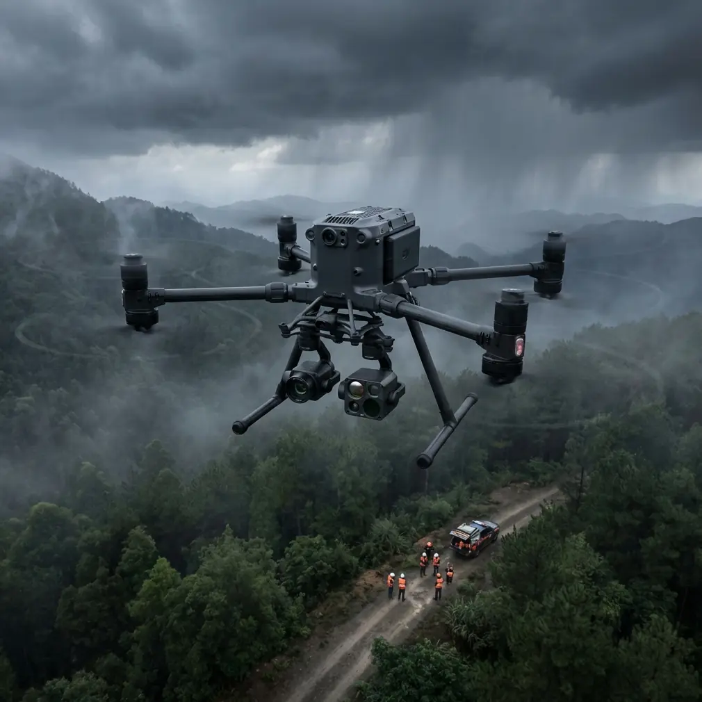
Why the Matrice 400 suits urban field work
The Matrice 400 is especially useful in urban inspection because these sites punish weak link reliability and clumsy power handling. When you are working near structures, fencing, roadways, and intermittent visual obstructions, stable command and video transport are not a luxury. They are part of risk control.
This is where O3 transmission becomes more than a spec-sheet acronym. In practical terms, a robust digital link gives you cleaner situational awareness when the aircraft moves behind visual clutter or across RF-noisy blocks. That matters during low-speed thermal confirmation passes, where you may need to hover briefly, reframe, and verify whether a hot patch is a drainage issue, a utility leak, stressed vegetation, or simply sun-loaded material near the target area.
Security also deserves more attention than it usually gets. If your inspection involves municipal property, critical infrastructure adjacency, or client-sensitive land data, AES-256 encryption is not an abstract checkbox. It reduces exposure in transmission and helps align the aircraft with professional data handling expectations. For teams operating in regulated or contract-heavy environments, that can influence where and how the platform gets approved for use.
My preferred mission order: thermal first, map second
For urban field inspection, I prefer to capture thermal data before the photogrammetry grid in most cases. The reason is simple: thermal usefulness decays faster as the day develops.
Surface temperatures shift quickly once sunlight, vehicle movement, and building reflections start changing the scene. If I need to identify irrigation failures, buried utility patterns, water ingress, stressed turf, or unusual heat retention along field edges, the cleanest data often comes from the earliest stable window available for the site.
Then I switch to the mapping run. Photogrammetry is generally more forgiving on timing, provided shadows and wind are manageable. This sequencing also helps battery planning because thermal passes tend to involve more pauses, more scrutiny, and more on-the-fly decisions, while the mapping mission is more structured.
That means your freshest batteries go toward the least predictable portion of the job.
The battery management tip that actually saves missions
Here is the field habit I recommend to every Matrice 400 operator: do not treat hot-swap batteries as permission to stay in the air until the last sensible minute.
Instead, define an early swap threshold based on the mission phase, not just the remaining percentage.
On urban field work, I usually rotate earlier during the thermal segment than I do during the mapping segment. Why? Because thermal inspection often forces unplanned hover time, angle adjustments, and repeated looks at anomalies. Battery drain becomes less predictable, especially when the pilot is making fine positioning corrections near structures or boundary obstacles.
My rule from the field is this: if I am entering a decision-heavy segment of the inspection, I want the aircraft carrying enough reserve that I never feel rushed into choosing between one more thermal confirmation and a conservative recovery. That mental margin improves judgment.
The hot-swap capability is valuable precisely because it keeps the workflow moving without a full shutdown cycle. But the operational advantage only appears when the crew uses it proactively. Swap while the mission is still tidy. Do not wait until the battery state starts dictating your inspection quality.
A related practice helps even more: label battery pairs by behavior, not just by number. Every experienced crew eventually notices that some sets recover voltage better under stop-start flight patterns, while others are better kept for steady automated mapping runs. Once you learn those tendencies, assign batteries to mission types accordingly.
Thermal signature work: what to watch in urban fields
Thermal inspection in urban environments is full of false positives. The Matrice 400 gives you the platform stability to identify patterns, but interpretation still depends on discipline.
When scanning an urban field, I am usually looking for one of four thermal behaviors:
- linear anomalies that may suggest subsurface utilities or drainage paths
- isolated hotspots tied to mechanical equipment, electrical features, or disturbed ground
- irregular cool zones that may indicate moisture retention or irrigation imbalance
- edge effects caused by adjacent structures, paving, or shaded boundaries
The operational significance here is that context beats raw temperature contrast. A hot strip along a field edge might mean buried infrastructure. Or it may simply reflect heat loading from nearby pavement. A cool patch might indicate water accumulation. Or it may sit in a recurring shadow line cast by a building.
That is why I always pair the thermal pass with visual references and note the surrounding materials. In urban inspection, you are rarely measuring the field alone. You are measuring the interaction between the field and the built environment around it.
Photogrammetry: make it measurable, not merely pretty
A surprising number of inspection teams still fly urban mapping missions that produce attractive orthomosaics but weak analytical value. If you need defensible measurements, stake your workflow on control.
That starts with GCP placement. In urban fields, edge control matters more than many operators realize. Interior points help, but perimeter geometry is usually where distortion sneaks in, especially when trees, fencing, walls, and mixed elevations complicate the scene. Place GCPs where they strengthen the outer structure of the map, not just where they are easy to access.
The Matrice 400 is well suited to these repeatable grid missions because it can move from manual inspection logic to systematic coverage without making the aircraft feel like a compromise in either role. But the real quality boost comes from planning overlap and altitude around the site’s vertical interference. If one side of the field is bordered by multi-story structures, that area deserves extra caution. Shadows, wind shear, and abrupt visual texture changes can all reduce reconstruction quality.
For teams documenting erosion, grading, drainage routes, or recurring maintenance issues, the combination of a controlled photogrammetry pass plus targeted thermal overlays can be far more useful than either dataset alone.
BVLOS thinking starts before the paperwork
BVLOS gets discussed as if it begins when the waiver or regulatory framework enters the picture. In practice, good BVLOS discipline starts much earlier, in how you structure the site.
Even if your mission remains within visual line of sight, urban inspection benefits from BVLOS-style planning because the environment creates many of the same hazards: intermittent obstructions, signal reflections, moving third parties, narrow recovery options, and higher consequence from route drift.
With the Matrice 400, I would build the mission as if I might need that higher level of procedural rigor anyway. That means:
- identifying likely signal trouble spots before launch
- defining hold points and recovery lanes away from traffic and pedestrians
- assigning observation responsibilities clearly if working with a crew
- separating manual investigative flight from automated route segments
- recording site-specific constraints for repeat visits
The practical result is fewer mid-flight surprises. It also makes repeat inspections cleaner, which matters when clients want change detection over time rather than one-off imagery.
Urban link reliability is not just about range
Operators often talk about transmission in terms of distance. That misses the real issue in city-adjacent field work. The challenge is not simply how far the aircraft can go. It is how consistently you can maintain control and image confidence as the site environment changes around the aircraft.
O3 transmission matters here because urban inspections often involve short but demanding signal paths. You may be operating relatively close to the aircraft while dealing with interference sources, partial obstructions, and reflective surfaces. A stronger transmission system improves your ability to judge framing, verify anomalies, and decide whether a second pass is necessary.
That is especially valuable during thermal verification. If you are trying to assess whether an unusual thermal signature is operationally meaningful, low-confidence video makes the entire flight less efficient.
A practical site workflow I would use
If I were training a crew to inspect urban fields with a Matrice 400, I would use this sequence:
Arrive early enough to walk the site and classify thermal contamination sources. Mark every nearby surface likely to skew readings: asphalt, metal fencing, parked vehicles, rooftop exhaust, glazed facades, and concrete drainage features.
Lay out GCPs before any major site traffic changes the environment. In urban areas, waiting too long often means your control points end up compromised by vehicles, maintenance crews, or public activity.
Fly the thermal mission first with fresh batteries. Move slowly and deliberately, and build in short pauses over anomalies rather than trying to “cover ground.” Thermal interpretation improves when you give yourself time to compare surrounding context.
Swap batteries earlier than your mapping instinct tells you to. This is where the hot-swap advantage pays off. Preserve decision margin.
Then run the photogrammetry mission with the site fully understood. You now know which areas deserve extra overlap, additional oblique looks, or post-processing attention.
If the client needs a quick field discussion while you are still on site, I usually show them the logic of the anomalies rather than raw conclusions. It builds confidence faster. If you need help structuring that kind of inspection workflow for your own crew, this direct field planning chat is a simple place to start.
Where crews usually underperform with the Matrice 400
Not because of the aircraft itself. Because they ask it to cover for poor process.
The common misses are predictable:
- treating thermal and mapping as one blended mission
- placing GCPs for convenience instead of geometric strength
- flying too late for reliable thermal comparison
- relying on battery percentage rather than mission-phase planning
- underestimating urban RF complexity despite having a strong link system
- skipping a repeatable site procedure because the aircraft feels capable enough to “figure it out”
The Matrice 400 rewards methodical operators. It is not just a platform for collecting more data. It is a platform that makes better inspection logic easier to execute under real site pressure.
Final take
If your job is inspecting fields in urban environments, the Matrice 400 is at its best when you use its strengths in combination rather than isolation. O3 transmission improves confidence in difficult urban signal conditions. AES-256 supports secure handling of sensitive operational data. Hot-swap batteries reduce downtime, but only if you use them before fatigue and low reserve start distorting decision-making. And when thermal signature analysis is paired with properly controlled photogrammetry and solid GCP placement, the result is not just better imagery. It is better judgment.
That is what clients actually notice. Not the aircraft name alone, but whether the mission produces answers that stand up after the flight is over.
Ready for your own Matrice 400? Contact our team for expert consultation.