Matrice 400 in Windy Field Inspections: A Practical Case
Matrice 400 in Windy Field Inspections: A Practical Case Study From the Edge of the Map
META: A field-tested Matrice 400 case study for windy agricultural inspections, covering battery management, thermal signature capture, photogrammetry workflow, O3 transmission, AES-256 security, and BVLOS-ready planning.
Wind changes everything in field inspection work.
Not in the abstract. Not in the way spec sheets like to imply. I mean the kind of wind that rolls across open acreage at first light, bends crop rows in visible waves, and forces every pilot to decide whether the mission is still useful, still safe, and still worth the battery they are about to spend.
That is exactly where the Matrice 400 becomes interesting.
For this article, I am not treating the aircraft as a generic flagship platform. I am looking at it through one specific lens: a windy agricultural inspection mission where the operator needs usable data, clean decision points, and enough endurance discipline to avoid wasting the best weather window of the day. If you inspect fields for drainage issues, crop stress, storm damage, irrigation performance, or perimeter conditions, the real question is not whether a large enterprise UAV can fly. It is whether it can keep producing reliable results when the environment starts taxing every part of the workflow at once.
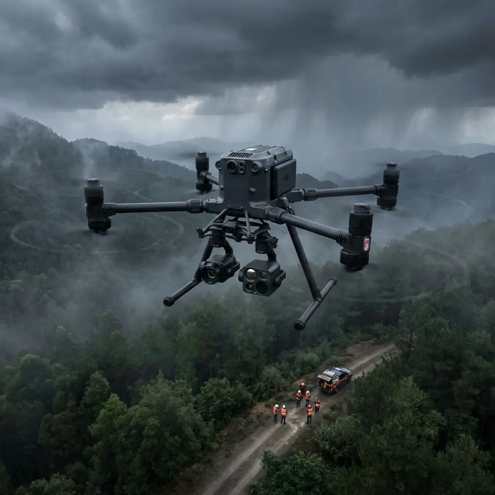
The Field Scenario
A few months ago, I worked with a team planning a multi-block inspection over exposed farmland with almost no natural windbreaks. The goal was not just visual observation. We needed layered outputs: a visible-light overview for structural context, thermal signature review for irrigation anomalies, and a photogrammetry pass over selected sections where subtle surface variation could reveal pooling, washout, or access-route degradation.
That kind of mission creates competing demands.
Thermal work usually rewards timing discipline and careful sensor management. Photogrammetry rewards repeatability, overlap, and stable flight behavior. Field operations reward speed, because weather windows are never as long as they look from the truck.
This is why the Matrice 400 platform matters in practical terms. A bigger aircraft with enterprise transmission, secure links, payload flexibility, and hot-swap batteries is not just “more powerful.” It changes how aggressively you can structure a mission in marginal conditions without turning the operation into a gamble.
Why Wind Exposes Weak Mission Planning
Many operators think wind is mainly a flight-stability problem. That is too narrow.
In agricultural inspections, wind also affects:
- image consistency during mapping runs
- thermal interpretation if foliage movement creates uneven readings
- battery draw during cross-field transits
- communication confidence at the far edge of the route
- landing precision when cycling batteries quickly between sorties
A windy field punishes lazy planning. If your route design is inefficient, if your battery rotation is casual, or if your takeoff point is chosen for convenience instead of recovery safety, the aircraft will reveal those mistakes fast.
The Matrice 400 gives crews more margin, but margin is only useful if the team knows where to spend it.
The First Operational Advantage: Hot-Swap Batteries Actually Change the Mission
The most underrated productivity feature in field inspection is not raw speed. It is continuity.
Hot-swap batteries matter because windy inspections often create a stop-start rhythm. You may complete a thermal pass, return with enough reserve for safety, switch power, and relaunch quickly before the sun angle changes or before gusting conditions worsen. On a platform that forces a slow reset between flights, you lose more than minutes. You lose consistency across the dataset.
On the Matrice 400, hot-swap capability supports a more disciplined sortie chain. That helps in two ways. First, it shortens the gap between successive passes over the same field zones. Second, it reduces the temptation to overextend a single flight just to avoid downtime.
That temptation is where battery mistakes happen.
My field battery rule in wind
Here is the battery management tip I give teams after seeing the same issue over and over: in windy field work, do not plan battery thresholds around the outbound leg. Plan them around the ugliest plausible return.
That sounds obvious until the mission is underway. Pilots see healthy battery numbers while moving with a tailwind across a long block, and the route looks efficient. Then the return leg starts, groundspeed falls, power draw rises, and the reserve that looked comfortable becomes thin very quickly.
With the Matrice 400, the correct habit is to use hot-swap flexibility to stay conservative earlier, not later. If the aircraft has already completed the priority thermal or mapping segment, bring it back and change batteries while the operation is still tidy. The extra continuity from fast swaps means you do not need to “stretch” each pack. In field conditions, that one mindset shift protects aircraft, payload, and data quality at the same time.
O3 Transmission Matters More Over Fields Than Many People Realize
Open farmland looks simple from the ground. From a radio perspective, it is not always forgiving.
Long, unobstructed routes can encourage crews to push farther than they should, especially when the inspection target is visible and the terrain appears benign. Reliable O3 transmission changes the quality of that decision-making. It gives operators stronger situational confidence over distance, particularly when inspecting remote corners of a property, drainage paths, access roads, or isolated equipment lines.
That operational significance is easy to miss. Better transmission is not just about range on paper. It directly affects how cleanly the pilot can evaluate aircraft state, payload output, and route progress while wind conditions continue to shift. In real missions, stable transmission means fewer second-guesses, fewer unnecessary pauses, and fewer rushed decisions during recovery.
If you are collecting thermal imagery, this matters even more. A thermal signature is only useful if the operator can trust what they are seeing in context. Losing confidence in the downlink during a critical segment turns a targeted inspection into an incomplete one.
Thermal Signature Work in Wind Requires Judgment, Not Just Sensor Access
Thermal payloads can reveal irrigation leaks, saturated ground, plant stress zones, failing electrical components around pumps, and abnormal heat patterns in support infrastructure. But wind complicates interpretation.
Moving leaves, changing surface cooling, and uneven exposure can all blur the operational meaning of a thermal image. On the Matrice 400, the value is not simply that you can carry the right payload. The value is that the platform is stable and capable enough to let the pilot slow down where interpretation matters and move faster where only transit matters.
In one field workflow, we used thermal as the first filter rather than the final deliverable. That distinction matters. The thermal pass identified suspicious temperature differences along a section with known irrigation inconsistency. Then a more structured visible-light and photogrammetry workflow provided the follow-up evidence needed for planning ground response.
That is a stronger use of enterprise UAVs in agriculture. Thermal tells you where to look. Mapping tells you what changed. The aircraft’s job is to support both without making you choose one at the expense of the other.
Photogrammetry Under Gust Load: Accuracy Depends on Discipline
Photogrammetry in exposed farmland is not glamorous. It is repetitive, technical, and easy to get wrong in small ways that compound later.
When operators use the Matrice 400 for mapping selected field zones, the real challenge is not whether the aircraft can carry out the route. It is whether the crew preserves enough consistency for the outputs to hold up when decisions are made from them. Wind can affect overlap quality, angle consistency, and motion behavior during turns. That means route planning and ground control become more valuable, not less.
This is where GCP discipline enters the picture.
Ground control points are not just a processing checkbox. In field environments with repeating textures and large open surfaces, GCPs anchor the model to something trustworthy. If the end user needs to assess erosion channels, water movement, ditch condition, or access-route wear, positional confidence matters. A polished map that drifts from reality is worse than no map at all because it invites false certainty.
The Matrice 400 supports a more robust data-collection workflow here because it is built for professional payload operations and repeatable mission structure. But the platform does not rescue poor geospatial habits. If you want useful photogrammetry in windy agricultural inspections, fly repeatable lines, control your timing, and place your GCPs like they will be audited later.
Because sometimes they will.
Security Is Not a Side Note in Agricultural Operations
Agricultural drone work often gets treated as harmless compared with utility or public-safety operations. That is a mistake.
Field inspections can expose operational layouts, crop conditions, infrastructure locations, water management practices, and access vulnerabilities. For large farms and agribusiness operators, that is sensitive operational intelligence. AES-256 encryption therefore has practical significance, not brochure significance.
When the Matrice 400 is used to inspect broad acreages, secure transmission and data-handling expectations become part of professional practice. This matters especially for contractors serving multiple clients, teams working under formal data policies, or operators integrating aerial data into larger agronomic or asset-management systems.
Put simply, if your aircraft is collecting strategic information, secure handling is part of the mission, even if the site is “just a field.”
BVLOS Thinking Starts Before the Regulator Conversation
A lot of crews bring up BVLOS only when talking about approvals. That is backwards.
BVLOS readiness starts operationally. It shows up in route design, link confidence, emergency planning, crew coordination, and battery strategy. Whether or not a specific mission is flown under BVLOS authorization, the Matrice 400 sits in the class of aircraft that invites larger-area planning. That means teams should build BVLOS-grade habits even during visual-line operations.
For windy field inspections, this includes:
- choosing staging points based on recovery logic, not parking convenience
- pre-identifying return corridors with the least turbulence exposure
- sequencing high-value data capture early in the sortie
- defining battery abort points before launch
- verifying communication performance at the far side of the survey area
Those are not theoretical best practices. They are what separate a smooth agricultural operation from a mission that comes home with partial data and a vague explanation.
If your team is refining that kind of workflow, I often suggest comparing procedures with other experienced operators before standardizing your checklist; this direct field ops chat can be a useful place to pressure-test assumptions.
What the Matrice 400 Actually Changes for Field Inspectors
The biggest misconception around high-end UAV platforms is that they make hard jobs easy.
They do not.
What they do, when properly deployed, is make hard jobs manageable at a higher standard. In windy field inspection work, the Matrice 400 earns its place by improving continuity, sensor flexibility, transmission confidence, and secure data handling in one operating package. Those are not luxury features. They are exactly the elements that start to matter when the field is large, the weather is imperfect, and the output has to support a real decision.
A smaller platform may still complete a basic visual pass. But once the mission requires thermal interpretation, selected photogrammetry, disciplined battery rotation, and the possibility of scaling toward BVLOS-style area coverage, the conversation changes. The aircraft is no longer just a camera carrier. It becomes the backbone of an information workflow.
That is the frame I would use for anyone evaluating the Matrice 400 for agricultural inspection.
Not “Can it fly in wind?”
That is too simple.
A better question is this: when wind starts eroding your time, your endurance, and your confidence, does the aircraft still help you produce data you can act on? In that test, the Matrice 400 makes a serious case for itself. Hot-swap batteries reduce pressure to overcommit a single sortie. O3 transmission supports stronger operational awareness across open ground. AES-256 aligns with the reality that farm data can be commercially sensitive. And for teams pairing thermal signature analysis with photogrammetry and GCP-backed mapping, the platform supports a workflow that is considerably more mature than a quick overflight.
Field inspections are won or lost on the details crews tend to underestimate: when they launch, how they route, what they capture first, and when they decide to come home.
The Matrice 400 does not replace that judgment.
It rewards it.
Ready for your own Matrice 400? Contact our team for expert consultation.