Matrice 400 for Remote Field Inspection: Fatigue
Matrice 400 for Remote Field Inspection: Fatigue-Aware Flight Planning and the Altitude That Usually Works Best
META: Expert guide to using Matrice 400 for remote field inspection, with practical flight altitude advice, fatigue-aware operations, thermal and photogrammetry workflow tips, and field-ready planning insight.
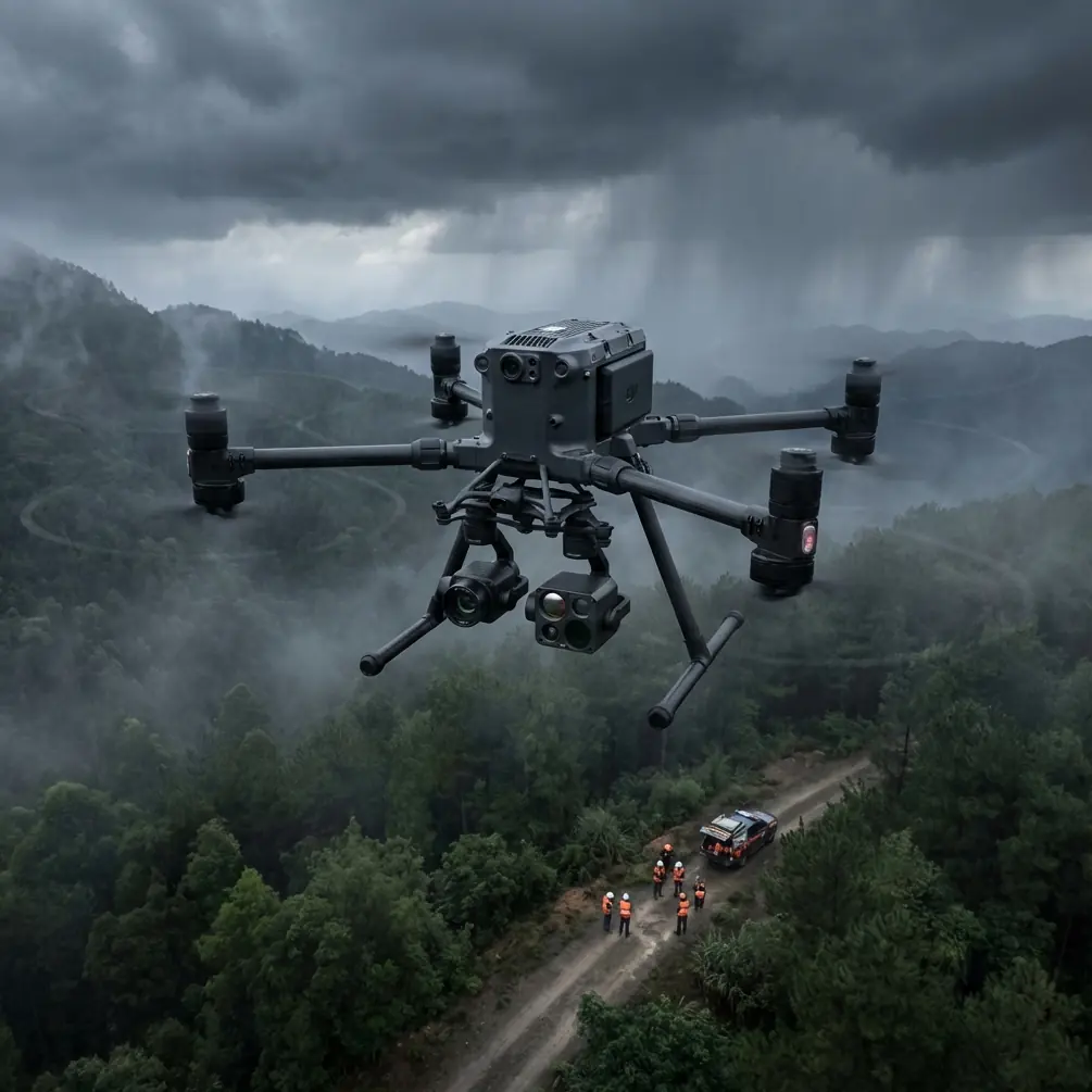
Remote field inspection looks simple from a distance. Launch the aircraft, fly the grid, collect thermal and RGB data, and head home. In practice, the hard part is repeatability. If you are using a Matrice 400 to inspect large agricultural blocks, utility corridors across farmland, or drainage infrastructure in isolated areas, the real question is not whether the aircraft can fly the mission. It is how to structure the mission so data quality stays stable over time while the airframe, power system, and crew workload remain under control.
That is where a useful engineering idea enters the conversation: not every flight hour affects the aircraft in the same way.
One of the reference materials behind this article comes from a helicopter design handbook discussing fatigue life assessment. It separates fatigue into high-cycle and low-cycle effects, then explains that preliminary service life can be estimated by combining the damage from both. The text gives that life in hours and frames the problem in a practical way: repeated smaller loading events and fewer larger loading events both matter, and they can be assessed together. A second detail from the same source is even more relevant to drone operations. It describes a full-range S-N curve approach as a simpler engineering method when load levels are close together and high-cycle fatigue dominates, while a separate high/low-cycle testing approach is more suitable when you need the complete picture of structural behavior.
That may sound like it belongs in a rotorcraft lab rather than a field inspection workflow. It does not. It translates directly to how a Matrice 400 should be flown over remote fields.
Why fatigue thinking matters for a Matrice 400 operator
If you inspect remote acreage every week, your aircraft is living in a repetitive world. Long straight survey legs, frequent waypoint turns, repeated climbs to legal operating height, descents for spot checks, and transport between rough launch sites all create loading cycles. Most of those are not dramatic. That is the point. The majority of wear in routine commercial drone work comes from repetition, not one obvious event.
For field inspection, most operators intuitively focus on battery count and image overlap. Fewer think about the operational split between:
- high-cycle loading, such as sustained rotor vibration, long cruise segments, and repeated small corrections in wind
- low-cycle loading, such as aggressive takeoffs, abrupt braking, sharp vertical changes, and repeated heavy-payload launches
The handbook’s logic is useful here because it reminds us that service life is not just “hours flown.” Two Matrice 400 fleets can log the same number of hours and age very differently depending on how they are flown.
For remote field work, that means the most efficient mission is often the one that reduces unnecessary low-cycle stress while preserving clean high-volume data capture.
The optimal altitude for remote fields is usually not the maximum you can use
Here is the practical insight most crews can apply immediately: for remote field inspection, a flight altitude around 60 to 90 meters above ground level is often the sweet spot for the Matrice 400, with about 75 meters AGL being a strong default starting point.
Why that range?
Because it balances four competing priorities better than either very low or very high flight profiles:
Photogrammetry consistency
At around 75 meters, you can usually maintain efficient ground coverage while preserving enough pixel detail for crop stress mapping, drainage assessment, row alignment review, and surface condition checks.Thermal usefulness
Thermal signature interpretation degrades when you push too high and lose spatial separation between features. Field drains, irrigation leaks, stressed canopy pockets, and warm equipment zones are easier to interpret when the aircraft is not needlessly elevated.Wind exposure and aircraft workload
Higher altitude often means stronger, less predictable wind. More correction means more small control inputs and more cumulative vibration exposure. That is exactly the kind of repetitive loading the fatigue handbook would classify within the high-cycle problem space.Mission efficiency without aggressive maneuvering
Flying too low forces more terrain reaction, obstacle management, and frequent adjustments around trees, poles, or uneven land contours. That adds low-cycle stress through repeated speed and altitude changes.
The best altitude is therefore not a fixed number for every field. It is the lowest altitude that gives the resolution you need without creating extra maneuvering. For many remote properties, that ends up near 75 meters.
A simple decision rule for choosing altitude
Start with the mission outcome, not the aircraft capability.
Use this field rule:
- 60 to 70 meters AGL for thermal-focused inspection where smaller anomalies matter
- 70 to 85 meters AGL for standard RGB mapping and photogrammetry across broad fields
- 85 to 90 meters AGL when obstacles are sparse, the site is very large, and the goal is rapid situational coverage rather than fine detail
If you are using GCPs, the lower half of that range usually gives you a better return on effort because the control points support stronger map confidence. If you are not using GCPs and are relying on onboard positioning plus post-processing discipline, avoid climbing so high that your final map becomes operationally “pretty” but analytically weak.
How the fatigue reference changes real mission design
The helicopter fatigue source describes two useful assessment mindsets. One is the full-range S-N curve method, favored partly because implementation is simpler. The other is a separate high-cycle and low-cycle evaluation method, useful when you need a fuller understanding of structural response. For drone operators, that distinction becomes a maintenance and flight-planning philosophy.
1. Treat routine mapping as a high-cycle dominant operation
Large-area field inspection is usually dominated by steady-state flying. Long legs. Modest turns. Consistent speed. Predictable altitude. That resembles the “high-cycle dominant” case described in the handbook, where repeated smaller loads define much of the structural story.
Operational significance:
If most of your Matrice 400 work is broadacre mapping, your best protection is consistency. Avoid overcontrolling the aircraft. Build repeatable templates. Use waypoint smoothing. Minimize abrupt stops and punchy climbs.
2. Identify where low-cycle damage enters the picture
The low-cycle component appears when crews rush setup, launch heavy, land hard on uneven ground, or repeatedly interrupt survey patterns for manual spot checks. Those are fewer events, but each can be more severe.
Operational significance:
A mission with three extra aggressive climb-outs from improvised field pads may be harder on the aircraft than one additional calm mapping leg. That matters when you are managing aircraft availability during peak growing season.
This is one reason hot-swap batteries are not just a convenience topic. In remote areas, hot-swap workflow reduces full power-down cycles and shortens turnaround, but the larger operational win is that it helps crews maintain a controlled mission rhythm. Fewer rushed relaunches. Less temptation to “make up time” with hard throttle inputs. Cleaner continuity across sorties.
Building a Matrice 400 workflow for remote fields
A strong field inspection workflow should reduce both data errors and unnecessary aircraft stress. Here is the structure I recommend.
Step 1: Split the mission into survey work and diagnostic work
Do not mix them in one improvised flight.
- Survey flight: fixed altitude, fixed overlap, steady speed, broad-area coverage
- Diagnostic flight: lower altitude, slower speed, targeted revisits for thermal or visual confirmation
This single change improves everything. Your map data becomes cleaner, and you stop injecting low-cycle maneuvering into a flight that should be smooth and repetitive.
Step 2: Use the first pass to establish anomalies, not explain them
For photogrammetry, fly the primary grid at your chosen mapping altitude, often around 75 meters AGL. For thermal inspection, run your thermal payload when surface conditions support useful contrast. Then review the anomaly pattern before dropping lower.
Do not descend every time you see something interesting during the first pass. That habit destroys consistency and adds needless fatigue loading through repeated transitions.
Step 3: Control turn behavior at the field edges
This is where many crews quietly abuse their aircraft.
At every row end or survey boundary, the aircraft can either:
- arc smoothly into the next leg, or
- brake hard, pivot, accelerate, and repeat
Multiply that by dozens or hundreds of turns over a season. The engineering implication is obvious. Smooth turns cut down on larger load reversals and reduce power spikes. They also produce better image geometry.
If your mapping software supports turn smoothing, use it. If you are flying manually for a targeted inspection, discipline matters even more.
Step 4: Choose altitude based on anomaly size, not operator anxiety
Operators often climb higher “to be safe,” especially in remote unfamiliar areas. That can be sensible around scattered trees or power lines, but it is not automatically better.
For fields, more altitude often means:
- lower thermal feature separation
- weaker visual confidence on localized stress
- stronger wind drift
- more correction inputs
- less consistent orthomosaic quality
If obstacle clearance allows, stay closer to the altitude that matches the size of the features you are actually looking for.
Step 5: Secure the data path, especially in isolated locations
Remote does not mean risk-free. It often means fewer fallback options.
If your Matrice 400 workflow includes live image review or remote team coordination, transmission integrity matters. O3-class transmission performance is valuable here because field crews are often operating across wide open areas with sparse support infrastructure. AES-256 level encryption is equally relevant when inspection imagery includes commercially sensitive land use, irrigation layouts, or infrastructure details.
These are not brochure features in this context. They affect whether a remote operation can be trusted as part of a professional reporting chain.
Thermal and photogrammetry: when to combine them and when not to
A lot of field teams want one flight to do everything. Sometimes that works. Often it dilutes both outputs.
Thermal signature analysis is sensitive to environmental timing and altitude discipline. Photogrammetry needs overlap, speed consistency, and image geometry. You can combine them when the mission objective is broad anomaly screening. But if the result must support decisions on irrigation faults, drainage failure, ponding, or vegetation stress boundaries, separate flights are usually cleaner.
The Matrice 400 earns its keep when you use it as a stable data platform, not as a flying compromise.
Remote field realities that matter more than spec-sheet reading
Three things matter in the field more than many operators expect.
Surface access
If your launch area is rough, muddy, or uneven, your landing discipline becomes part of aircraft life management. Low-cycle events begin on the ground as much as in the air.
Crew impatience
The more isolated the site, the more likely crews are to push tempo after a long drive. That often leads to rushed battery changes, casual preflight checks, and manual corrections that should have been solved in planning.
Connectivity assumptions
Remote work tempts crews to overtrust autonomy. Always plan for continuity if you lose ideal links, and verify your mission logic before launch.
If you want help shaping a field-ready workflow around your payload mix and acreage pattern, this is a useful place to start a direct conversation: message our UAV team on WhatsApp.
A note on applying aircraft-design references to drone operations
One of the references provided for this article comes from helicopter fatigue design, not from a Matrice-series manual. That matters, and it is exactly why it is useful.
The source is not telling us how many hours a Matrice 400 arm, motor mount, or structural member will last. It is giving us a better way to think. Specifically:
- service life is influenced by both high-cycle and low-cycle damage
- simplified evaluation methods are practical when operating loads are relatively uniform
- fuller separation of loading types is more useful when operational patterns vary sharply
That framework helps explain why two agricultural drone programs with similar annual flight time can produce very different maintenance outcomes.
The second reference in the source package discusses civil aircraft emergency exit sizing, including figures such as 510 mm width and 1530 mm height for a tail-cone type exit. Those numbers are clearly rooted in manned aircraft evacuation design, not unmanned field inspection. For Matrice 400 planning, they do not carry direct operational value, so they should not shape how we think about remote drone inspection. The fatigue reference does.
That distinction matters because expertise is not about repeating every source fact. It is about knowing which facts apply.
What experienced Matrice 400 teams do differently
They do not just fly missions. They normalize load patterns.
They pick a working altitude and keep it stable.
They separate survey work from diagnosis.
They use GCP strategy where accuracy justifies it.
They avoid jerky edges and rushed recoveries.
They treat thermal signature capture as a timing problem, not just a sensor problem.
They leverage secure transmission and disciplined handoff procedures when operating far from base.
And they understand that repeated “small” flying habits eventually become maintenance reality.
If you are inspecting remote fields with a Matrice 400, the smartest adjustment is usually not a dramatic one. It is often a calmer one: fly a little more deliberately, hold an altitude that matches the features you need to resolve, and structure the mission so the aircraft spends most of its time doing steady work.
That is good for your map. Good for your thermal data. Good for your batteries. And over time, probably good for the aircraft itself.
Ready for your own Matrice 400? Contact our team for expert consultation.