Matrice 400 in Remote Forest Inspection: A Field Report
Matrice 400 in Remote Forest Inspection: A Field Report on What Actually Matters
META: Expert field report on using Matrice 400 for remote forest inspection, covering turnaround time, maintenance logic, thermal workflows, transmission reliability, and payload strategy.
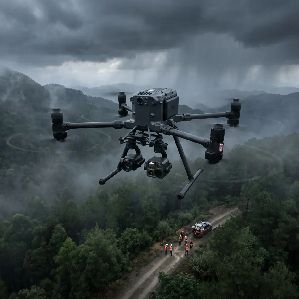
Remote forest inspection exposes a drone faster than almost any marketing demo ever will.
Dense canopy ruins sightlines. Terrain interrupts signal paths. Moisture works its way into connectors and landing zones. Missions stretch long enough that battery management stops being a checklist item and becomes the rhythm of the day. If you are evaluating the Matrice 400 for this kind of work, the real question is not whether it can fly over trees. Plenty of platforms can do that. The question is whether the aircraft, the support workflow, and the payload strategy hold together when the forest is far from roads, far from bench power, and far from second chances.
That is where the Matrice 400 deserves to be judged: not as a brochure object, but as an operational system.
The forest changes the rules
A remote woodland inspection mission usually asks one aircraft to do several jobs in a single deployment. You may need thermal signature detection for stressed vegetation or hotspot identification, visible-light imaging for bark damage and corridor encroachment, and photogrammetry runs for terrain and canopy edge documentation. If the site is large enough, the mission profile starts to look less like a simple drone sortie and more like a compact aviation operation.
That distinction matters. One of the most useful ideas buried in traditional aircraft support literature is the concept of turnaround time. In the referenced aircraft design material, turnaround time is defined as the period needed after arrival to complete the repair, inspection, maintenance, and service actions required before the aircraft returns to operation. That sounds like airline language, but it maps cleanly onto drone work in the field.
For a Matrice 400 crew in a remote forest, turnaround time is not theoretical. It is the difference between finishing a drainage corridor before fog rolls in and losing the second half of the day to battery cooling, payload reconfiguration, and troubleshooting. The best drone teams I’ve worked with do not just track flight time. They track what happens between flights. That is where efficiency is won or lost.
Why aviation-style maintenance thinking belongs in heavy UAV work
The same reference material also breaks maintenance into levels: line maintenance, workshop maintenance, and base maintenance. Again, this may sound distant from a field drone deployment, but it is exactly the right lens for a Matrice 400 used in industrial inspection.
Line maintenance in forestry operations is what happens at the launch point. That includes rotor inspection, quick cleaning, connector checks, payload latch verification, firmware status confirmation, battery health review, and the basic lubrication and servicing steps that preserve intended performance. The original document explicitly identifies lubrication and servicing as a maintenance type used to preserve built-in design performance. On a large multirotor in muddy, remote conditions, that principle is not optional. It is one reason some aircraft age gracefully while others become unreliable far too early.
Workshop maintenance is what your field team cannot or should not attempt under a canopy tarp. If a gimbal cable starts throwing intermittent faults, if a thermal payload develops calibration drift, or if a power distribution issue appears only under load, forcing a field fix wastes more time than it saves. The handbook’s distinction is practical: some work belongs at a higher technical tier with better test equipment, spare parts, and documentation. Serious Matrice 400 operators understand that “keeping missions moving” and “repairing everything on site” are not the same skill.
Base maintenance, in drone terms, means planned deep inspection and refurbishment cycles. Forest work is punishing. Moisture, organic debris, and repeated transport into rough terrain slowly stack up. A platform that is expected to support BVLOS-style planning, long-range mapping, or repeated thermal inspection sorties needs a maintenance architecture, not just a pilot.
That may sound dry until you price the cost of a missed inspection window or a rescheduled forestry contractor team. Suddenly maintenance hierarchy is not admin. It is mission continuity.
Payload planning matters more than headline specs
One strange but useful reference in the source material is a tabulated breakdown of component weights in crewed aircraft. The models listed are not relevant to civilian drone work, but the underlying lesson absolutely is: airframes are systems of tradeoffs, and payload decisions affect everything.
In one table, electronic equipment on an F-4E is listed at 2,227 lb, while control systems are listed at 1,167 lb. The exact numbers belong to another class of aircraft entirely, but the engineering principle scales down cleanly. Sensors, control hardware, support systems, and mission equipment all compete for capacity and influence endurance, stability, and serviceability.
For Matrice 400 forest inspection, this shows up when operators start stacking expectations onto one platform. A thermal payload for hotspot detection. A high-resolution visual sensor for photogrammetry. Possibly a spotlight, relay device, or specialized third-party module. Every addition has consequences in endurance, heat management, balance, and workflow complexity.
This is why payload strategy should begin with the inspection question, not the accessory catalog.
If the job is to detect stressed sections of forest edge after a hot spell, thermal signature quality and repeatable flight geometry matter more than carrying every sensor available. If the job is to generate orthomosaics and terrain products for erosion analysis, photogrammetry discipline matters more than improvising with mixed capture profiles. GCP placement, route consistency, and overlap planning become the real source of usable data.
The Matrice 400 is at its best when configured deliberately. Not maximally. Deliberately.
A third-party accessory that genuinely improved the mission
One of the more effective upgrades I have seen on forest deployments was not exotic. It was a third-party high-gain directional antenna kit used at the ground station for difficult terrain.
In remote woods, the aircraft may be fine while the control link struggles because ridgelines and dense tree mass interrupt clean propagation. Operators often blame the drone first. In reality, the weak point may be the ground-side link geometry. A well-integrated accessory that improves directional signal handling can make O3 transmission performance more consistent in broken terrain, especially during low-altitude passes along forest corridors or when working beyond a visual line that would otherwise be interrupted by vegetation.
That does not replace sound flight planning, and it does not erase regulatory obligations around BVLOS. It simply gives the crew a stronger communications posture in the environments where forests tend to cause trouble. The result is fewer pauses, fewer nervous recoveries, and better confidence during repeatable inspection lines.
If you are sorting out a forest inspection configuration and want to compare antenna, payload, or battery workflow options, this Matrice 400 setup discussion channel is one practical place to start.
Thermal work in forests is less forgiving than people expect
Thermal imaging in forest inspection sounds straightforward until you actually try to extract reliable meaning from it.
Canopy layers trap heat differently. Moisture changes the surface response. Sun angle can create false contrast. A thermal signature that looks suspicious at midday may disappear into background noise in late afternoon, while dawn can reveal patterns that visible imaging would miss completely. That is why the Matrice 400’s value in this sector is tied less to “having thermal” and more to supporting disciplined thermal operations.
You need a stable platform, predictable hover and tracking behavior, dependable transmission, and enough battery flexibility to revisit anomalies without rethinking the whole day’s mission plan. Hot-swap batteries matter here for a simple reason: they reduce the operational penalty of interruption. In forest work, interruptions are constant. A blocked trail, a radio shadow, a weather shift, a revised target list from the client. If your aircraft can return, swap efficiently, and go again without turning a 15-minute pause into a 45-minute reset, that compounds over a full field day.
That is turnaround time again, just in drone language.
Photogrammetry under canopy-edge conditions
Matrice 400 conversations often drift toward payloads and range, but mapping performance in forest environments depends just as heavily on method.
Photogrammetry over forest edges and access corridors is a data discipline. Tree movement from wind creates reconstruction errors. Shadows produce inconsistent textures. Elevation changes demand route planning that respects terrain rather than imposing a flat-grid fantasy on a mountain slope. GCPs become particularly useful when the area includes partial canopy openings, logging roads, drainage cuts, or landslip zones where decision-makers want spatial outputs they can trust.
In those conditions, the drone’s job is to fly the plan repeatably. The operator’s job is to avoid asking one sortie to be both a cinematic scan, a thermal patrol, and a mapping mission at the same time. This is where that drone film festival reference offers an odd but relevant insight.
Aerial imagery can be visually spectacular. Jay Worsley’s New York City Drone Film Festival nomination was built on dramatic footage of coastlines and mountain ranges. The point is not the festival itself. It is the reminder that striking aerial images and operational inspection data are not the same product, even when both come from the same aircraft class. Forest clients may love beautiful top-down views, but they pay attention when imagery becomes measurable evidence: repeatable overlap, thermal consistency, georeferenced outputs, and documented anomalies.
The Matrice 400 can absolutely produce impressive visuals. In remote inspection, that should be the byproduct, not the objective.
Security and trust are part of the platform decision
Forestry projects increasingly involve sensitive geospatial information: concession boundaries, infrastructure routes, environmental compliance zones, fire-risk assessments, and private land records. That is why transmission and data security deserve more than a passing mention.
If your operation depends on O3 transmission for stable field control and AES-256 for protected data handling, those are not abstract spec-sheet decorations. They shape whether a client trusts the platform for recurring work. A drone that reaches the target but introduces uncertainty around link integrity or information exposure creates a different kind of risk. In remote inspection, technical competence now includes digital hygiene.
The crews that win repeat assignments understand this. They do not just explain flight safety. They explain how mission data is handled, who accesses it, and how the operation preserves chain-of-custody for findings.
The Matrice 400 is strongest when treated as a system
After enough field days, the pattern becomes obvious.
The aircraft alone does not make the mission work. What works is the combination of platform stability, smart payload selection, maintenance discipline, efficient battery handling, and a ground-side process built for quick recovery between sorties. That is why the maintenance language from conventional aviation feels so relevant here. Repair, inspection, servicing, and re-entry into operation are not separate from mission performance. They are mission performance.
For remote forest inspection, that means asking harder questions than “How far can it fly?”
How quickly can the crew reset after a wet landing zone and relaunch? How cleanly can they separate field checks from workshop-level faults? How much unnecessary payload weight are they carrying into steep terrain? How often does the transmission link force compromises in route design? Can they switch from thermal anomaly work to photogrammetry without contaminating both datasets with poor planning?
Those are Matrice 400 questions too. They are just the questions that show up after the unboxing phase.
And for serious operators, they are the only ones worth asking.
Ready for your own Matrice 400? Contact our team for expert consultation.