Matrice 400 for Solar Farm Inspection in Complex Terrain
Matrice 400 for Solar Farm Inspection in Complex Terrain: What Actually Matters in the Field
META: A technical review of Matrice 400 for solar farm inspection in complex terrain, with practical insight on flight altitude, thermal workflow, transmission resilience, and reliability details that shape real-world results.
By Dr. Lisa Wang, Specialist
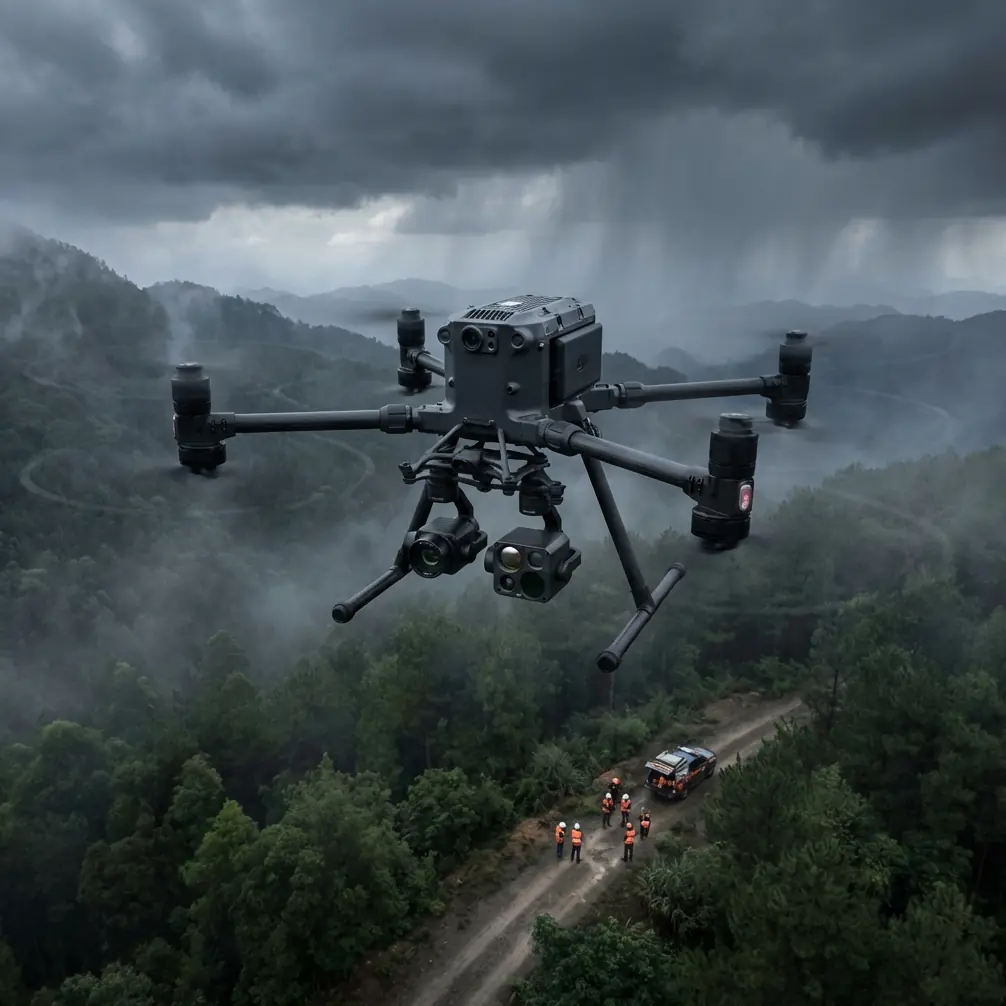
Solar farm inspection sounds straightforward until the site stops behaving like a flat map.
The trouble starts when arrays step down a hillside, access roads cut through ravines, reflections shift with slope angle, and your aircraft has to keep stable telemetry while moving between changing elevations. In that setting, the value of a platform like the Matrice 400 is not just payload capacity or headline endurance. It is whether the aircraft can maintain data quality, link integrity, and operational continuity when the terrain keeps trying to break the workflow.
That is the frame I want to use here. Not a generic platform overview, but a field-centered technical read on how a Matrice 400-class system fits solar inspection in uneven ground, and what operators should think about before they commit to a flight plan.
The real inspection problem in complex terrain
A solar site built across rolling ground creates three simultaneous problems.
First, your imaging geometry changes constantly. A flight altitude that is acceptable over one ridge can be too high over the next descending section, reducing thermal anomaly visibility and softening small defect signatures. Second, the radio environment becomes less predictable. Terrain, inverter stations, and long row geometry can all affect command-and-control confidence. Third, mission efficiency drops if you are repeatedly landing to adjust setup, batteries, or payload parameters.
The Matrice 400 becomes interesting in this environment because it addresses more than one bottleneck at the same time. Its relevance is operational, not cosmetic.
Optimal flight altitude: lower than many teams think, but not blindly low
If your goal is fault detection on modules rather than broad progress documentation, the best altitude in complex terrain is usually the lowest altitude that still preserves safe row clearance, clean overlap, and mission continuity across elevation changes.
For thermal signature work on solar arrays, many crews make the mistake of choosing altitude based on the full site boundary instead of the module-level defect they need to resolve. In practice, the more useful method is terrain-aware altitude management referenced to the surface, not just a single takeoff point. That is especially true in stepped or sloped installations.
My own rule for this scenario is simple: for thermal inspection, keep the aircraft close enough to preserve actionable temperature contrast at the module level, but high enough to avoid excessive gimbal correction and row-to-row turbulence effects. On complex terrain, that usually means flying to a consistent above-ground profile rather than a fixed absolute altitude. If the site has sharp elevation variation, a static mission height can quietly ruin consistency.
Why does this matter? Because a thermal signature is only valuable if it is comparable across strings and blocks. A hotspot captured from one geometry and one distance is not perfectly comparable to a hotspot captured from another. The issue is not whether the camera “saw something.” The issue is whether the data supports maintenance prioritization with confidence.
The Matrice 400’s value here is in supporting a disciplined terrain-sensitive workflow. Pair that with proper photogrammetry planning and surveyed GCP placement when you need geospatially defensible reporting, and the inspection becomes much more than a visual sweep.
Thermal and photogrammetry should not be treated as separate worlds
On solar farms, thermal flights often get isolated from mapping flights. That separation is understandable, but on difficult topography it can create blind spots.
Thermal tells you where the problem likely is. Photogrammetry tells you exactly how that problem sits in physical context: row spacing, slope break, drainage path, access route, nearby obstructions, and precise asset location. If you are inspecting a large terrain-diverse site, the best results come from connecting both datasets in one planning logic.
That means:
- thermal mission height should be chosen for defect visibility,
- photogrammetry mission parameters should be chosen for usable reconstruction,
- and GCP strategy should reflect terrain changes instead of being clustered around easy access points.
Complex terrain makes bad control placement obvious. A few GCPs near a service road do not solve vertical variation across the entire site. If your aim is repeatable comparison over time, terrain-distributed control matters.
This is where Matrice 400-level stability and transmission confidence begin to pay off. The aircraft is not just moving a camera. It is enabling a data chain that has to remain coherent from capture through analysis.
Why transmission quality matters more in solar than many operators admit
Solar farms can be deceptively hostile to link performance. Long repetitive panel geometry, scattered electrical infrastructure, and terrain shielding can all combine to make the mission feel fine right up until the link gets unstable at the far side of a slope.
That is why O3 transmission is not a brochure detail in this use case. It affects whether the pilot and sensor operator can trust live framing, inspect edge cases in real time, and maintain confidence when the aircraft transitions over changing ground relief. In a complex site, the aircraft may still be airborne and technically within range while your real-time decision quality degrades. That gap matters.
For inspection teams working toward more scalable operations, especially those planning future BVLOS-aligned workflows where regulations permit, transmission resilience becomes part of the business case. You need a platform that keeps the aircraft useful, not just airborne.
Link security matters too. AES-256 is relevant when inspection data includes utility infrastructure, energy production layouts, or client-sensitive asset information. Solar farm operators are increasingly careful about how site imagery and thermal findings move across systems. Strong encryption does not improve a thermal image, but it does improve trust in the overall inspection process.
Reliability is not abstract: small details decide whether a mission day stays productive
Here is where the reference material, although not written for a drone article, points to something worth discussing.
One source describes the use of Infineon MemTool to calculate a checksum for a hex file, including a workflow where the operator connects, opens the file, and uses Device -> Calculate Device Checksum. It also references PFLASH capacity at 1 MByte in the XMC4500 environment and shows a resulting checksum value of 84. On the surface, this is embedded development housekeeping.
Operationally, it signals something bigger: verification discipline.
For a Matrice 400 deployed on high-throughput inspection programs, reliability is not only about motors, batteries, and airframe redundancy. It is also about confidence that controller-side logic, payload integrations, or support electronics are behaving exactly as intended. Checksums matter because corruption and mismatch errors rarely announce themselves dramatically. They show up as odd behavior, inconsistent performance, or wasted field hours. In a solar inspection context, where mission windows can be narrow due to irradiance conditions, that kind of avoidable uncertainty is expensive in time even if we are not discussing cost.
The lesson is not that operators need to become firmware engineers. The lesson is that robust drone operations are built on verification culture. If your team customizes workflows, logs data pipelines, or integrates specialized peripherals, the checksum mindset is healthy. Confirm the system state. Trust, but verify.
The second reference looks even further removed from drones: an aircraft materials handbook entry on steel-wire-braided rubber hose construction. But it contains a concrete engineering principle with direct relevance. It distinguishes hose structures with one steel-wire braid layer and others with two, and it specifies a 0.3 mm steel wire core material. It also lists dimensional examples such as the 21R8-100 hose with an inner diameter of 8 and a weight value of 0.53.
Why does that matter to a Matrice 400 article? Because solar inspection in complex terrain is punishing on support systems. Hoses, damped lines, protective sleeves, and flexible routing components in payloads or ground-support equipment are easy to ignore until vibration, repeated transport, temperature cycling, and field handling expose weak design assumptions. The handbook’s distinction between one-layer and two-layer reinforcement is a reminder that engineering durability is often hidden in the parts nobody photographs. When an inspection program scales, material choices begin to show up as downtime or consistency.
This is the difference between drone ownership and inspection operations engineering.
Hot-swap batteries are more strategic than they sound
Battery swaps are usually discussed as convenience. That undersells their value.
On solar sites in broken terrain, your launch and recovery area is not always beside the block you are inspecting next. If the platform supports hot-swap batteries effectively, the crew can reduce the dead time between sorties and preserve mission rhythm during changing thermal conditions. That matters because thermal results are tied to environmental timing. Clouds move. Surface heating evolves. Wind changes.
A slow battery cycle can force you to compare morning behavior on one section against late-window behavior on another. That is not ideal for anomaly consistency. Hot-swap capability helps teams keep the capture window tighter, which can improve dataset uniformity across large sites.
This becomes even more valuable when the operator is coordinating both thermal and visual collection on the same day and trying to avoid fragmented coverage.
Flight planning for sloped solar arrays: what I recommend
For a Matrice 400 inspecting solar farms in complex terrain, I recommend a planning workflow built around four decisions.
1. Define the mission by defect class, not by acreage
If the site owner cares about hotspot screening, PID-related indicators, connector issues, or string-level irregularities, your altitude and speed must be built around detection needs. Do not let the sheer size of the farm push you into overly coarse capture.
2. Use terrain-following logic whenever the site relief justifies it
A fixed takeoff-relative height can make one half of the site sharp and the other half mediocre. Terrain-aware altitude control preserves more consistent imaging geometry.
3. Place GCPs where the terrain changes, not where parking is easy
Photogrammetry quality on sloped installations depends on control distribution. Put control where the model is stressed.
4. Treat transmission shadow zones as planning constraints
Before the full mission, run a short reconnaissance segment to identify areas where terrain or infrastructure affects O3 link confidence. Adjust pathing before the primary inspection run.
These are not glamorous choices. They are the choices that determine whether the output is defendable.
What makes Matrice 400 the right fit here
A serious solar inspection platform needs to do three things well at the same time:
- carry the right sensing package reliably,
- maintain stable command and data awareness across difficult ground,
- and keep the crew moving through a long site day without workflow collapse.
That is why the Matrice 400 deserves attention for this scenario. Not because it is a flagship name, but because complex terrain punishes weak integration. You notice transmission weakness sooner. You notice battery inefficiency sooner. You notice inconsistent mission geometry sooner. The better the platform, the less time you spend managing around limitations.
If your team is building a repeatable solar inspection program rather than occasional one-off flights, those differences compound quickly.
And if you are evaluating mission design for a real site, a quick technical discussion can save a lot of trial and error in the field. You can reach out here for mission-specific planning notes: message our drone specialists on WhatsApp.
Final take
The Matrice 400 makes the most sense for solar farm inspection in complex terrain when you stop thinking of the aircraft as an isolated flying camera and start seeing it as part of a measurement system.
That system depends on altitude discipline for thermal signature integrity. It depends on photogrammetry and GCP planning to make findings spatially useful. It depends on O3 transmission to maintain decision quality across uneven ground. It depends on AES-256 to protect sensitive infrastructure data. It depends on hot-swap batteries to preserve mission continuity during narrow environmental windows.
And, as the reference materials quietly remind us, it also depends on engineering habits that most people overlook: verification at the firmware level, and durability in the physical components that live behind the visible payload stack.
That is the real standard for inspecting solar farms in difficult terrain. Not whether the drone can fly the route, but whether the entire operation keeps its accuracy, consistency, and reliability when the site gets complicated.
Ready for your own Matrice 400? Contact our team for expert consultation.