How to Inspect High-Altitude Venues with M400
How to Inspect High-Altitude Venues with M400
META: Learn how the Matrice 400 drone handles high-altitude venue inspections with thermal imaging, O3 transmission, and BVLOS capability. Expert tutorial inside.
By James Mitchell | Drone Operations Specialist & Certified UAS Instructor
TL;DR
- The Matrice 400 operates reliably at 7,000m+ altitudes, outperforming most enterprise drones for high-altitude venue inspections.
- Hot-swap batteries eliminate downtime during multi-structure venue surveys, keeping your mission continuous.
- Integrated thermal signature detection and photogrammetry workflows let you identify structural defects invisible to the naked eye.
- AES-256 encryption and O3 transmission ensure secure, uninterrupted data links even in RF-congested stadium environments.
Why High-Altitude Venue Inspections Demand a Purpose-Built Drone
Inspecting venues at elevation—ski resort lodges, mountain amphitheaters, high-altitude stadiums, telecommunications towers on ridgelines—pushes consumer and mid-tier drones past their limits. Thin air reduces rotor efficiency. Temperature swings drain batteries faster. Signal interference from metal-heavy structures kills video feeds at the worst possible moment.
The DJI Matrice 400 was engineered specifically for these punishing conditions. This tutorial walks you through a complete high-altitude venue inspection workflow, from pre-flight planning to deliverable generation, so you can execute surveys safely, efficiently, and with data your clients actually trust.
Step 1: Pre-Mission Planning and Site Assessment
Evaluate the Venue and Altitude Variables
Before you unbox the M400, you need a thorough site assessment. High-altitude venues introduce variables that sea-level operators rarely encounter:
- Air density reduction: At 3,000m, air density drops roughly 25% compared to sea level, reducing lift and increasing power consumption.
- Temperature extremes: Mountain venues can swing 20–30°C within a single day, affecting battery chemistry and sensor calibration.
- Wind shear: Venues nestled in valleys or on ridgelines experience unpredictable gusts that demand a drone with robust stabilization.
The M400's flight controller automatically compensates for altitude-related air density changes, adjusting motor output in real time. This is a critical differentiator—many competing platforms like the older Matrice 300 RTK require manual parameter adjustments for flights above 2,500m.
Set Ground Control Points (GCPs)
For any inspection that requires dimensionally accurate deliverables, you need GCPs distributed across the venue. Place a minimum of 5 GCPs for structures under 10,000 sq meters and 8–12 GCPs for larger complexes.
Pro Tip: At high altitude, GPS accuracy can actually improve due to reduced atmospheric interference, but don't rely on this. Always use RTK-corrected GCP coordinates. The M400's built-in RTK module delivers 1cm + 1ppm horizontal accuracy, giving your photogrammetry outputs survey-grade precision without a base station in many scenarios.
Use clearly visible, high-contrast targets—black and white checkerboard patterns work best against snow, rock, or concrete surfaces common at mountain venues.
Step 2: Configure the Matrice 400 for High-Altitude Operations
Battery Strategy: Hot-Swap Is Non-Negotiable
Battery performance degrades at altitude and in cold temperatures. At 4,000m with ambient temperatures around -5°C, expect roughly 20–30% less flight time compared to manufacturer specs at sea level.
The M400's hot-swap battery system is the single feature that separates it from virtually every competitor in this scenario. You can replace one battery while the drone hovers on the remaining pack—no landing, no reboot, no recalibration. For a multi-structure venue inspection that might require 4–6 flights, this feature alone can save 45–60 minutes of cumulative downtime.
- Pre-warm batteries to 20–25°C before insertion.
- Carry at least 3 battery sets for a full venue survey.
- Monitor cell voltage differential during flight; the M400's telemetry displays per-cell data in real time.
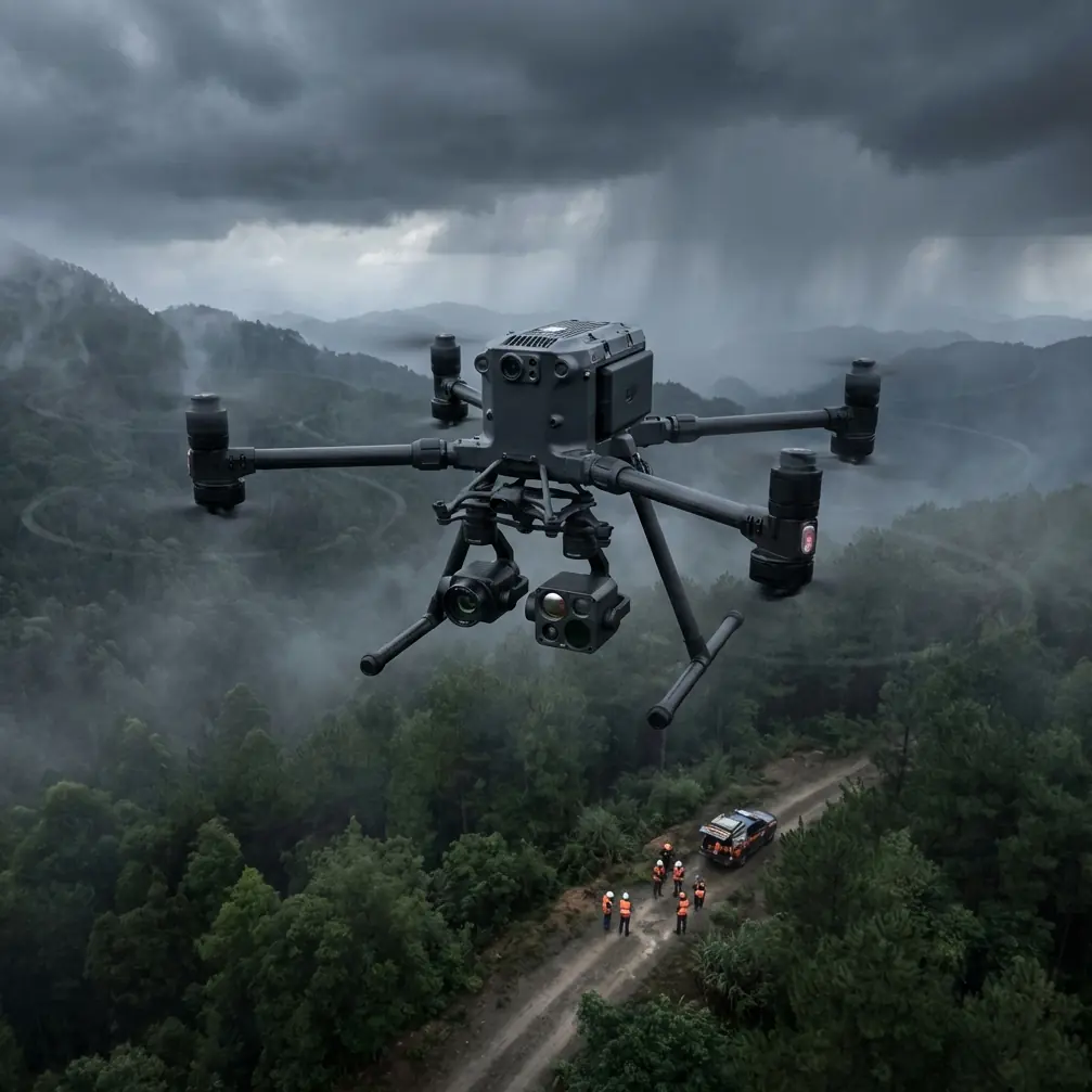
Payload Selection
For venue inspections, a dual-sensor configuration is standard:
- Wide-angle visual camera for structural documentation and photogrammetry data capture.
- Radiometric thermal sensor for detecting thermal signatures that indicate moisture intrusion, insulation failure, electrical hotspots, or HVAC inefficiencies.
The M400 supports simultaneous dual-payload operation without significant flight time penalty—its max takeoff weight tolerance accommodates heavy sensor configurations even in thin air.
Step 3: Execute the Inspection Flight
Automated Flight Paths vs. Manual Piloting
For repeatable, comprehensive coverage, use automated waypoint missions for the primary survey. The M400's flight planning software allows you to:
- Define 3D waypoint missions that wrap around complex structures like stadium seating bowls or multi-level lodge rooflines.
- Set gimbal angles and camera triggers at each waypoint for consistent overlap (75% frontal, 65% side is the minimum for clean photogrammetry reconstruction).
- Program altitude-relative-to-terrain flights using onboard terrain-following radar—essential when venues sit on sloped terrain.
For detail work—cracks, joint failures, antenna mounts—switch to manual control with the M400's O3 transmission system feeding 1080p/60fps live video to your controller at up to 20km range. In practice, you'll rarely be beyond 500m during venue work, but the O3 link's robustness matters in RF-noisy environments filled with broadcast equipment, Wi-Fi networks, and metallic structures that cause multipath interference.
Expert Insight: I've flown competing platforms at venues with active broadcast infrastructure and experienced video dropouts at just 200m line-of-sight distance. The M400's O3 transmission maintained a clean feed at the same locations without a single frame drop. When you're documenting a defect on a roofline 80m above ground, you cannot afford a frozen screen.
BVLOS Considerations
Some large venue complexes—particularly ski resorts or festival grounds spread across mountain terrain—may require BVLOS (Beyond Visual Line of Sight) operations. The M400 supports BVLOS workflows with:
- ADS-B In receiver for manned aircraft awareness.
- Redundant flight controllers and AES-256 encrypted command links that meet regulatory requirements for extended-range operations.
- Automatic return-to-home with obstacle avoidance if the command link is lost.
Always confirm BVLOS authorization with your national aviation authority before executing these flights. In the United States, this requires an FAA Part 107 waiver. In the EU, specific SORA assessments apply.
Step 4: Data Processing and Deliverable Generation
After landing, your data pipeline typically follows this workflow:
- Ingest visual and thermal imagery into photogrammetry software (Pix4D, DJI Terra, or Agisoft Metashape).
- Align images using GCP coordinates for georeferenced accuracy.
- Generate orthomosaics, 3D point clouds, and thermal overlays.
- Annotate defects with measurement data and thermal differential values.
- Export client-ready reports in PDF or interactive 3D viewer formats.
The M400's geotagged imagery includes precise altitude, GPS, and gimbal orientation metadata, which dramatically reduces processing errors during the alignment phase.
Technical Comparison: M400 vs. Competing Platforms for High-Altitude Venue Work
| Feature | Matrice 400 | Matrice 300 RTK | Autel EVO Max 4T | Skydio X10 |
|---|---|---|---|---|
| Max Operating Altitude | 7,000m | 5,000m | 4,000m (est.) | Not specified |
| Hot-Swap Batteries | Yes | No | No | No |
| Transmission System | O3 (20km) | OcuSync 2.0 (15km) | Autel SkyLink (15km) | Skydio Link (10km) |
| Data Encryption | AES-256 | AES-256 | AES-256 | AES-256 |
| RTK Built-In | Yes | Yes (module) | No (accessory) | Yes |
| Dual Payload Simultaneous | Yes | Yes | Single gimbal | Single gimbal |
| IP Rating | IP55 | IP45 | IP43 | IP55 |
| Max Flight Time (sea level) | 55 min | 55 min | 42 min | 40 min |
The M400's combination of 7,000m altitude ceiling and hot-swap batteries creates a clear operational advantage that no single competitor matches for high-altitude inspection work.
Common Mistakes to Avoid
Skipping battery pre-warming: Cold batteries at altitude can trigger low-voltage warnings within minutes. Always warm packs to at least 20°C before flight.
Using sea-level flight time estimates: Plan for 25–35% reduced flight time at altitude. Running batteries to minimum thresholds on a mountain ridgeline with unpredictable winds is reckless.
Neglecting GCP placement: Relying solely on onboard GPS for photogrammetry at altitude produces deliverables with 5–10m positional errors. GCPs bring this down to centimeter-level.
Ignoring thermal calibration: Thermal sensors require flat-field calibration adjustments for ambient temperature. Uncalibrated thermal data produces false-positive thermal signature readings that erode client trust.
Flying without a spotter in complex venues: Stadiums, arenas, and resort complexes have cables, guy-wires, and antennae that don't appear on satellite imagery. A dedicated visual observer prevents catastrophic collisions.
Overlooking data security: Venue owners—especially government or entertainment industry clients—require proof that inspection data is encrypted. Confirm AES-256 encryption is active on both the transmission link and stored media before every mission.
Frequently Asked Questions
Can the Matrice 400 handle snow and rain during high-altitude venue inspections?
The M400 carries an IP55 protection rating, meaning it can operate in moderate rain and light snow. Heavy precipitation or blizzard conditions remain no-fly scenarios—not because of the drone's capability, but because moisture on lens elements degrades imagery quality and makes thermal data unreliable. Always carry lens wipes and a sensor cover for quick protection between flights.
How many batteries do I need for a full venue inspection at altitude?
Plan on 3–4 battery sets for a medium-sized venue (stadium, resort lodge complex) at altitudes between 2,500–4,000m. The hot-swap system means you can cycle through sets continuously, but each set will deliver roughly 35–40 minutes of effective flight time at altitude rather than the rated 55 minutes at sea level.
Is BVLOS authorization required for large venue inspections?
It depends on the venue footprint and your operational geometry. If you can maintain direct visual contact with the M400 throughout the entire flight—or use visual observers positioned to maintain continuous visual coverage—standard VLOS rules apply. For sprawling mountain resort complexes where terrain blocks line of sight, you'll need a BVLOS waiver or equivalent authorization from your aviation regulator. The M400's redundant systems and AES-256 encrypted command link support the safety case documentation these applications require.
Ready for your own Matrice 400? Contact our team for expert consultation.