How I’d Use a Matrice 400 to Inspect Urban Venues During Tim
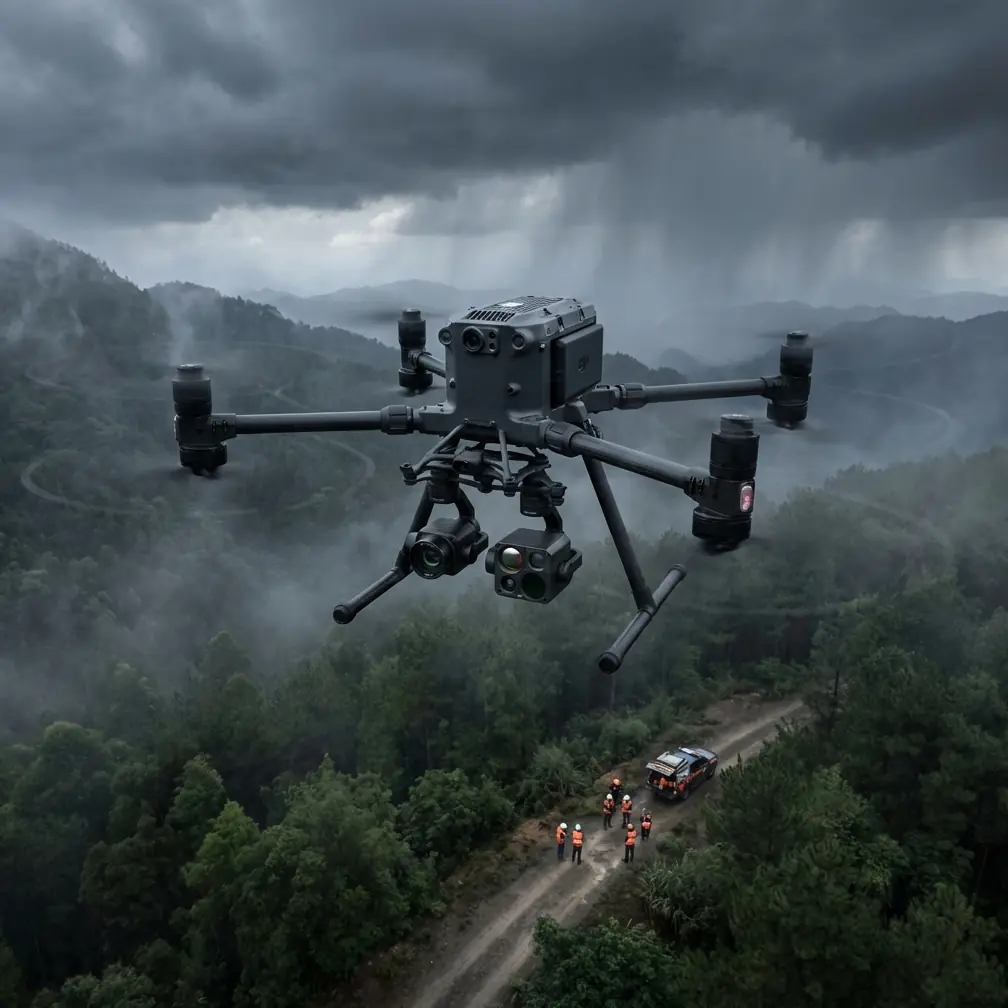
How I’d Use a Matrice 400 to Inspect Urban Venues During Time-Critical Field Operations
META: A field-driven look at how Matrice 400-style drone workflows fit urban venue inspection, using recent agricultural UAV deployment lessons to explain timing, payload strategy, data quality, and operational discipline.
Urban venue inspection sounds clean on paper. Stadium roofs, exhibition halls, transport-adjacent event spaces, civic plazas, temporary structures. In reality, the job is rarely neat. Access windows are short. Surrounding buildings distort GNSS performance. Wind behaves differently at roofline than it does at launch point. And when a site manager says “we need answers today,” the aircraft matters less than the workflow built around it.
That is where the Matrice 400 discussion gets interesting.
Most product writeups stay trapped at the feature sheet level. For venue inspection, that misses the point. The more useful question is this: what kind of operating logic should a serious team build around a platform like the M400 when the environment is urban, the timeline is compressed, and the output must be decision-grade?
A recent field example from Anhui provides a surprisingly relevant answer, even though it came from agriculture rather than urban infrastructure. In Wuhe County’s Toupu Town, local authorities pushed drone spraying during a critical wheat grain-filling period. The task was not casual flying. The crop was at a stage where yield formation was highly sensitive, and risks included hot dry wind, premature aging, lodging, and pest pressure. The local agricultural service center issued a focused mid-to-late-stage wheat management bulletin covering technical points like irrigation, lodging prevention, and pest control. Then they did something that matters to any professional drone operator: they paired the guidance with timing discipline and field execution, instructing farmers to conduct operations in the early morning or evening using drones.
That detail is easy to overlook. It should not be.
For urban venue inspection, early-morning and late-day windows often produce the difference between usable data and compromised data. In agriculture, those windows reduce drift, evaporation, and stress on the crop treatment process. In city inspection, the same logic translates into calmer air, lower pedestrian conflict, more stable thermal conditions for certain sensor tasks, and cleaner visual capture before glare and rooftop heat distortion build. A Matrice 400 is only as good as the operator’s willingness to fly when the environment supports the mission.
The lesson from wheat fields applies directly to urban concrete
The Toupu Town operation also emphasized “one spray, multiple protections,” combining leaf fertilizer and plant growth regulator application to tackle several threats during one intervention. Strip away the agricultural specifics, and you get a broader UAV principle: one sortie should solve multiple data problems whenever possible.
That principle maps cleanly to the M400 in venue inspection.
If I am inspecting an urban venue, I do not want a flight plan that captures only roof imagery if the same mission can also collect thermal signature data, façade obliques, drainage evidence, and photogrammetry inputs for a measurable 3D model. The operational value comes from stacking outcomes efficiently. One aircraft movement, several decision layers.
For example, after a storm or before a major event, an inspection team may need to assess:
- membrane roof condition
- water pooling near drainage paths
- HVAC anomalies
- temporary rigging positions
- façade access constraints
- crowd-flow obstruction points around perimeter structures
A Matrice 400-class workflow becomes powerful when payload selection and route design are built for this kind of overlap. Visual mapping alone gives geometry. Thermal signature adds condition clues that standard RGB cannot show. Oblique capture supports engineering review around parapets and trusses. If GCP-backed photogrammetry is part of the workflow, the venue team gets measurable outputs rather than attractive pictures that nobody can trust quantitatively.
Why timing discipline matters more than people admit
The reference case from Toupu Town did not just mention drones. It mentioned active guidance from field technicians and explicit reminders to monitor weather changes. Again, that is not just an agriculture story. It is a blueprint for venue inspection operations in dense environments.
Urban site inspection has a weather problem that many crews underestimate. Forecast apps describe regional conditions; venues create microclimates. A plaza framed by towers channels gusts. A stadium bowl traps heat. A rooftop over mechanical exhaust creates localized turbulence. If the mission involves thermal work, solar loading can alter readings dramatically across the same building envelope within hours.
That is why the “watch weather closely, then use the window” approach from the wheat-management campaign matters operationally. It reduces the temptation to treat drone inspection as an anytime task. Serious venue teams know better.
With an M400, I would plan around three specific timing objectives:
- Low-wind image stability for façade and roof edge inspection
- Controlled thermal contrast depending on whether I want to find heat buildup, moisture retention, or insulation irregularity
- Low-conflict site occupancy to simplify takeoff, perimeter control, and repeatable flight paths
In some cases, the best thermal window is not the best photogrammetry window. That may justify two targeted flight periods rather than one oversized mission. If the aircraft supports fast turnaround and hot-swap batteries, those split missions become practical instead of painful.
The real M400 advantage is continuity under pressure
This is where battery strategy stops being a convenience and becomes an inspection asset.
Urban venue jobs often break down into interrupted segments: a roof sector now, a loading zone after site access clears, an exterior pass once sunlight angle improves, then a final thermal run after the structure begins cooling. Hot-swap batteries support continuity across those mission fragments. You avoid rebuilding operator rhythm and can keep the inspection logic coherent across one operational block.
That continuity matters most when stakeholders are waiting onsite. Engineers, facility managers, contractors, insurers, event coordinators—they all want answers from the same inspection cycle. If the aircraft can stay in a repeatable, high-readiness loop, the M400 becomes less of a drone and more of an airborne site instrument.
I would pair that with a third-party accessory that often gets overlooked: a high-output strobe or beacon system from a specialist accessory supplier, especially for dawn or dusk urban work where visual conspicuity matters around rooftops and service corridors. It does not change the sensor stack, but it can materially improve operational awareness and crew coordination in complex surroundings. Accessory choices like that are rarely glamorous, yet they often make the workflow safer and smoother than another spec-sheet upgrade.
Data confidence is the dividing line between inspection and guesswork
A venue operator does not really need aerial media. They need evidence they can act on.
That is why photogrammetry discipline matters. If I am using a Matrice 400 for venue inspection, I am thinking early about overlap, camera angle strategy, and whether GCPs are necessary. On a simple roof documentation job, RTK-level positioning and careful mission planning may be enough. In a denser urban venue, where surrounding vertical surfaces and partial signal blockage can reduce positional confidence, GCPs can still be the difference between “close enough” and “approved for engineering markup.”
That distinction carries downstream value. A measurable model lets teams quantify deformation, verify clearances for temporary installations, estimate repair area, or compare pre-event and post-event conditions. It also improves communication between departments that do not speak the same technical language. The drone team can hand over a model that a facilities manager, architect, and contractor all read differently—but use productively.
The Toupu Town case illustrates this in a non-mapping context. Their local agricultural center did not simply tell people to fly. It created a practical instruction sheet covering dry hot wind prevention, lodging prevention, pest management, and scientific irrigation. That is a structured decision framework. Urban drone teams need the same thing. Not a marketing brochure. A mission playbook.
For venues, that playbook should define:
- what condition indicators the inspection is trying to confirm
- which payload captures each indicator best
- what weather thresholds stop or reshape the mission
- where GCPs are worth deploying
- when thermal data is valid
- how imagery gets labeled for downstream teams
- what cybersecurity controls apply to storage and transfer
On that last point, urban venue inspections can involve sensitive layouts, mechanical systems, access routes, and high-profile sites. That makes secure transmission and storage a nontrivial requirement. If your workflow uses modern encrypted links such as AES-256, that should not be treated as a luxury bullet point. It is part of responsible site-data handling.
Transmission reliability changes everything in urban missions
Dense city environments punish weak links. Reflection, interference, and line-of-sight issues do not just threaten convenience; they interrupt inspection logic.
If the M400 deployment includes a robust transmission ecosystem such as O3-class performance, the benefit is not only range. In venue work, the bigger gain is confidence while positioning precisely around structures, maintaining stable situational awareness, and preserving image review flow without signal anxiety dominating crew attention.
For rooftop inspection in particular, transmission consistency helps the pilot and payload operator work as a team rather than as two people reacting to lag and uncertainty. That matters when examining expansion joints, edge protection systems, cladding transitions, signage mountings, or water ingress paths that may require small framing adjustments and repeated passes.
A strong link also improves the practicality of remote stakeholder participation. Engineers do not always need to stand next to the pilot. With the right setup, they can review feeds from a safe observation point and request additional looks in real time. That shortens the loop between capture and action.
If you are building a venue inspection workflow and want to compare payload fit, accessories, or comms setup around this kind of urban job, I’d suggest starting the conversation here: message the drone integration team directly.
BVLOS is not the headline here, but planning for scale matters
For compact venues, most work will remain within a tightly managed visual line-of-sight operation. Still, organizations that inspect multiple campuses, linked facilities, parking structures, or linear event infrastructure should think ahead. The value of an M400-class platform grows when the same operating framework can expand toward more advanced missions, including future BVLOS-ready procedures where regulations and approvals allow.
That does not mean forcing long-range operations into a city environment where they do not belong. It means choosing an aircraft and data architecture that can scale from today’s roof and façade work into tomorrow’s broader asset-inspection ecosystem without rewriting everything from scratch.
The central takeaway: the platform matters, but the operating method matters more
The wheat-field case from Toupu Town is useful because it shows what effective drone deployment looks like under real pressure. The crop was at a critical stage. Risks were known. Guidance was written and distributed. Weather was monitored. Operations were timed to early morning or evening. Drones were used not as gadgets, but as practical tools inside a coordinated response.
That same mindset is exactly how I would approach urban venue inspection with the Matrice 400.
Not by asking whether the aircraft can fly over a roof. Most professional platforms can.
The better question is whether the mission design extracts full value from each launch:
- capturing multiple inspection layers in one operational cycle
- choosing the right time window for stable and meaningful data
- using thermal signature where it adds diagnostic value
- anchoring photogrammetry with GCPs when measurement integrity matters
- maintaining continuity through hot-swap battery operations
- protecting sensitive site data with strong encrypted workflows
- preserving command confidence with dependable transmission in difficult urban geometry
That is what separates an impressive drone from a useful inspection system.
If you are responsible for venues, event infrastructure, or urban facilities, that difference has consequences. One approach gives you imagery. The other gives you a repeatable method for making maintenance, safety, and readiness decisions faster.
And that, more than any spec headline, is why the Matrice 400 deserves attention.
Ready for your own Matrice 400? Contact our team for expert consultation.