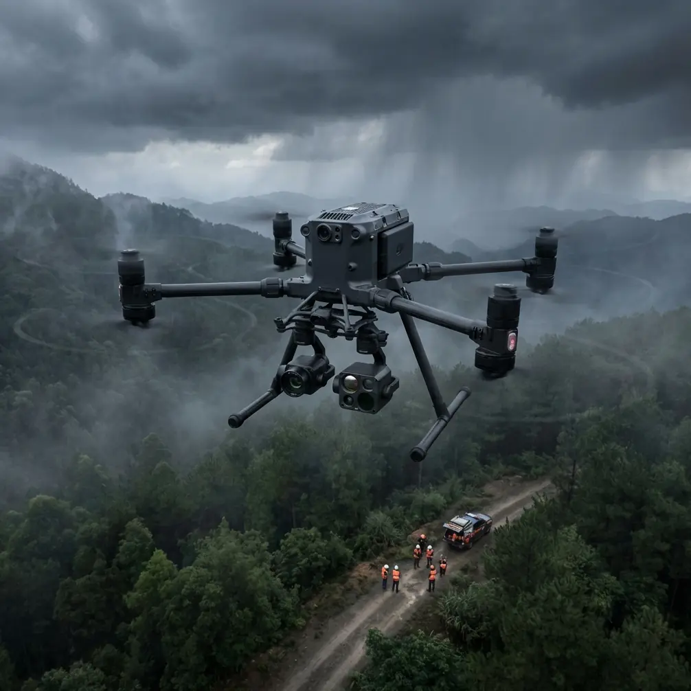
Inspecting Wildlife in Remote Terrain With the Matrice 400
Inspecting Wildlife in Remote Terrain With the Matrice 400: Practical Field Tactics That Actually Matter
META: Expert technical review of the Matrice 400 for remote wildlife inspection, covering thermal workflows, antenna positioning, O3 transmission, AES-256 security, hot-swap batteries, BVLOS planning, and photogrammetry tips.
Remote wildlife inspection is one of the few drone missions where aircraft capability, operator discipline, and field judgment all collide at once. You are not just trying to capture usable imagery. You are trying to find animals without pushing them, document habitat without contaminating it, and maintain a reliable air link in places where terrain, vegetation, and distance work against you.
That is exactly where the Matrice 400 deserves a serious look.
This is not a generic “bigger drone equals better results” argument. In wildlife operations, the aircraft only proves its value if it solves specific field problems: maintaining stable control beyond ridgelines, carrying sensors that can separate heat from background clutter, supporting repeatable mapping passes, and keeping downtime low when daylight windows are short. For remote inspections, those factors matter more than spec-sheet theater.
What makes the Matrice 400 especially relevant is how its mission profile lines up with conservation and ecological work. The platform is built for endurance-oriented, sensor-driven operations rather than casual visual capture. If your job involves locating nests, counting herd movement, checking fence corridors, identifying thermal signatures at dawn, or building habitat maps for later analysis, the aircraft’s real appeal is operational continuity. It helps you stay on task when the environment starts stripping away your margins.
Why remote wildlife inspection is a harder drone mission than most teams admit
A wildlife survey in remote country looks simple on paper. Launch, fly, collect data, land. In practice, it is a layered risk exercise.
You may be working from an improvised launch point with no nearby infrastructure. The site may have broken topography, patchy GNSS quality under tree cover, and temperature swings that alter battery behavior across a single sortie. The target itself may be transient. Animals move, rest in shadow, cluster under canopy, or blend into ground textures that flatten contrast in RGB imagery.
That means the drone has to do several things well at once. It needs a dependable transmission link, enough lift and stability for useful payloads, efficient energy management, and a workflow that lets the crew adapt without tearing down the whole mission plan.
The Matrice 400’s relevance starts there. It is not just about flying far. It is about staying effective when your line of sight, data confidence, and retrieval options are all less forgiving than they would be on an industrial site or urban inspection.
Thermal is only useful when the workflow is disciplined
For wildlife operators, “thermal signature” is one of the most abused phrases in the field. Spotting heat is not the same as identifying an animal, and identifying an animal is not the same as collecting evidence fit for analysis. A capable platform helps, but the real value comes from how cleanly it supports the workflow.
The Matrice 400 is well suited to thermal inspection because remote wildlife work often requires deliberate sensor pairing. Thermal helps you detect. Visual payloads help you classify. Mapping data helps you understand context. That combination matters when you are trying to distinguish a deer from a sun-warmed rock shelf, a nesting colony from residual ground heat, or a den entrance from general terrain variation.
Timing is critical. The best thermal windows are often early morning, late evening, or in cooler ambient conditions when animal heat stands apart from the landscape. A platform that can get airborne quickly and stay ready through multiple target passes saves valuable minutes in those windows. This is where hot-swap batteries become operationally significant. On wildlife missions, battery exchange is not just a convenience feature. It reduces the dead time between sorties when animal movement patterns may shift in 10 to 15 minutes.
If your team is trying to monitor a remote herd corridor at first light, the difference between a full shutdown cycle and a hot-swap workflow can mean catching the crossing or missing it entirely.
Antenna positioning advice for maximum range
Most range problems in remote wildlife inspection are not caused by the aircraft. They are caused by poor ground setup.
Operators talk about transmission systems like they are magic. They are not. Even a strong link such as O3 transmission still depends on geometry, line discipline, and operator behavior. In open country, the limiting factor is often not raw capability but how badly the crew positions itself relative to the terrain.
Here is the advice I give field teams using the Matrice 400 for maximum practical range and cleaner signal behavior:
First, get the controller station above local clutter whenever possible. A small rise, a rocky outcrop, or even a vehicle roof platform can improve the radio path more than many crews expect. A few meters of elevation can reduce signal shadowing from brush, undulating ground, or boulder fields.
Second, do not point the tips of the antennas at the aircraft. That is a common mistake. The broadside of the antenna pattern is where performance is strongest. Keep the antenna faces oriented so the aircraft sits in the strongest part of the pattern as it moves out. If the aircraft is changing altitude or crossing laterally, make smooth orientation adjustments rather than constantly chasing it with exaggerated movements.
Third, keep your body out of the signal path. On foot surveys, I regularly see operators rotate their torso and unknowingly place their own body between controller and aircraft. Human tissue absorbs radio energy better than most people realize. If you are operating at range, stance matters.
Fourth, avoid launching from the bottom of a bowl, valley floor, or treeline notch if the mission immediately climbs behind terrain. Start from a place where the first segment of flight preserves the cleanest possible line of sight. The best launch point is not always the closest point to the wildlife target.
Finally, build the route around the link, not against it. If a ridge is likely to block the transmission path, offset the flight line and approach from a shallower angle instead of forcing a direct path. O3 transmission can be highly capable in the field, but terrain still wins when you hand it every advantage.
If your team wants help planning that kind of setup for a specific reserve or survey corridor, you can message an operations specialist here.
O3 transmission matters because wildlife sites punish weak links
Transmission stability is not glamorous, but it directly affects data quality. A weak or inconsistent link forces conservative flight behavior, shortens useful stand-off distance, and makes framing and tracking harder when the subject is moving. In wildlife work, those constraints have consequences. You may need to stay far enough away to avoid disturbance, yet close enough to classify what you are seeing. A cleaner link expands that operating envelope.
That is why O3 transmission is more than a marketing shorthand in this context. Its significance is operational: it supports more confident aircraft placement in challenging terrain and gives the pilot more usable control fidelity when the survey area is wide, irregular, and remote.
For animal welfare, this matters as much as pilot comfort. Better transmission lets crews observe from a more respectful distance, reducing the pressure to push the aircraft lower or nearer just to preserve image confidence.
AES-256 is not just for corporate security departments
Wildlife inspection often involves sensitive information. Nesting sites, anti-poaching patrol routes, migration bottlenecks, den locations, and the presence of rare species are all data points that should not move loosely through field operations. Yet many teams still think about drone security only after the flying is done.
AES-256 support is significant because it raises the standard for protecting mission data in transit and within connected workflows. For ecological consultancies, NGOs, protected-area managers, and contractors working under permit, that matters. If your survey identifies an active nesting area for a vulnerable species, that information can become a liability if mishandled.
The security discussion around the Matrice 400 should therefore be practical, not abstract. If your operation collects location-linked imagery that could expose sensitive habitats, encryption is part of responsible fieldcraft. It belongs in the same conversation as observer placement, battery planning, and disturbance minimization.
Photogrammetry still has a place in wildlife work
Remote wildlife inspection is not only about detecting animals. Much of the value lies in documenting habitat condition, erosion patterns, water access, vegetation loss, and human encroachment. That is where photogrammetry becomes a serious companion workflow.
The Matrice 400 is a useful platform when missions need to shift from direct observation to spatial documentation. A team can inspect a wildlife corridor thermally at dawn, then return later for a structured mapping run that supports habitat analysis. Those are different tasks, but on a remote deployment it is often the same crew doing both.
If you are building orthomosaics or terrain models, GCP use still deserves careful thought. In accessible zones, ground control points improve positional confidence and make change detection more trustworthy over time. In truly remote or sensitive habitat, however, placing GCPs may be intrusive or simply impractical. That is where teams need to balance accuracy requirements against disturbance risk and field time.
The key is to define the decision threshold before launch. If the map will support relative change monitoring, broad habitat planning, or visual recordkeeping, fewer ground interventions may be acceptable. If the output is feeding engineering-grade restoration work or legal documentation, your control strategy needs to be tighter.
Either way, the aircraft is most valuable when it supports both observation and repeatability. Wildlife operations are full of one-off sightings, but conservation decisions are built on repeatable data.
BVLOS changes the scale of what is possible, but it raises the standard too
BVLOS is one of those terms people throw around casually until they are in a real remote mission with uneven terrain, intermittent visual references, and a moving target that does not care about your flight plan.
For wildlife teams, BVLOS capability is attractive because survey corridors can be long, irregular, and difficult to access on foot. Fence lines, river systems, migration edges, coastal wetlands, and forest breaks all lend themselves to extended drone coverage. A platform like the Matrice 400 can support that style of operation, but the significance is not simply “cover more ground.” It is “cover more ground with discipline.”
The moment you move toward BVLOS-style operations, pre-mission planning must tighten. Transmission geometry, emergency landing logic, terrain profile review, observer roles, airspace coordination, battery reserves, and lost-link behavior all become central. In wildlife work, you also have the added obligation to avoid pushing animals with repeated overflight or unnecessary loitering.
This is where a capable aircraft can either make a professional team more effective or tempt an unprepared team into avoidable risk. The Matrice 400 belongs in the first category only when the crew treats its range and mission capability as tools to be governed, not exploited.
What the Matrice 400 does well for remote wildlife teams
The aircraft’s strongest case for wildlife inspection is not a single feature. It is the way several mission-relevant capabilities reinforce each other.
Hot-swap batteries reduce downtime during narrow thermal windows. O3 transmission helps preserve control and data confidence at stand-off distances that are better for animals and safer for crews. AES-256 supports the protection of sensitive ecological data. A payload-capable mission architecture allows a team to shift between thermal search, visual verification, and site mapping without changing the entire operating concept.
Those are not abstract advantages. They directly affect whether your sortie produces reliable evidence or just interesting footage.
The Matrice 400 is therefore best understood as a field platform for teams who need continuity. Not speed for its own sake. Not size for its own sake. Continuity of observation, continuity of data capture, and continuity of mission tempo in places where interruptions are expensive.
Final field judgment
If your work involves inspecting wildlife in remote country, the Matrice 400 is compelling for a simple reason: it addresses the bottlenecks that actually limit mission success. Link quality. Sensor flexibility. battery turnover. Data protection. Repeatable survey execution.
That does not mean it replaces fieldcraft. No drone does. You still need disciplined antenna positioning, conservative route design, species-aware operating altitude, and a clear threshold for when thermal, visual, or photogrammetric data is good enough to support a real decision.
But with the right crew and the right workflow, the Matrice 400 becomes more than a platform that can reach remote terrain. It becomes a platform that can work there properly.
Ready for your own Matrice 400? Contact our team for expert consultation.