Matrice 400 for Windy Coastline Mapping: A Field Tutorial
Matrice 400 for Windy Coastline Mapping: A Field Tutorial That Prioritizes Data Quality
META: Practical tutorial on using the Matrice 400 for coastline mapping in windy conditions, including flight planning, photogrammetry, thermal workflows, transmission stability, battery strategy, and accessory choices.
Coastline mapping looks simple on a screen. In the field, it rarely is.
Wind shifts fast. Salt spray creeps into everything. Light bounces off water and confuses exposure. Ground control points can be awkward to place, and even when the aircraft is stable, your data can still come back with soft edges, reflective gaps, or poor overlap where cliffs, dunes, and surf zones meet.
That is why the Matrice 400 deserves to be discussed as a field system, not just as an airframe.
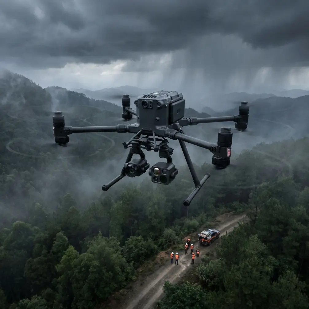
For coastal survey teams, the real question is not whether the platform can fly. It is whether it can keep producing usable mapping data when the shoreline is working against you. In windy conditions, that comes down to three things: aircraft stability, transmission confidence, and a workflow built around redundancy. The Matrice 400 sits in that conversation because it is designed for enterprise operations where payload flexibility, endurance management, and controlled mission execution matter more than headline specs in isolation.
This tutorial is written from the perspective of a specialist planning shoreline mapping with a Matrice 400 in difficult coastal wind. I will focus on practical decisions that affect photogrammetry quality, thermal capture value, battery handling, and mission continuity.
Start with the coastline, not the aircraft
A common mistake in marine-adjacent mapping is to treat the coast like a standard land survey block. It is not.
A coastline is a mixed-surface environment. Sand, rock, vegetation, standing water, moving water, foam, and built structures can appear in one flight line. Each of those surfaces reflects light differently. Wind adds another layer by moving grasses, pushing waves into brighter highlights, and forcing small corrections from the aircraft throughout the route.
The Matrice 400 becomes useful here because it supports the kind of disciplined, repeatable mission planning needed for complex survey zones. When teams mention long linear assets, corridor work, or extended inspection routes, this class of platform makes sense because it is built for serious operational continuity rather than short, improvised flights.
For a windy coastline, I recommend dividing the job into three mapping environments:
Dry, stable ground above the tide line
This is your easiest photogrammetry zone and should be captured to the highest confidence standard.Transitional shoreline
Wet sand, tidal debris, rocks, and shallow pools create variable texture and reflections.Water-adjacent edge conditions
This is where standard orthomosaic expectations break down. Treat these data as boundary context, not always as precision mapping equivalents to dry land.
That distinction matters because it affects how you evaluate mission success. A perfect map of the entire visible coastline is often unrealistic in strong wind and active surf. A reliable geospatial product of the stable shoreline, erosion boundary, access path, drainage features, and infrastructure edge is usually the commercial objective.
Wind strategy is really overlap strategy
When crews say, “The wind was manageable,” I usually ask a different question: “What did your overlap look like after the gusts?”
Wind does not just challenge control. It changes effective image geometry. Small yaw corrections, slight speed variation, and occasional tilt compensation can reduce the consistency that photogrammetry software expects. The result is often not a failed mission. It is a patchy reconstruction that only reveals problems once processing begins.
With the Matrice 400, the goal is to use platform stability and mission automation to protect overlap quality, not merely to complete the route.
For windy coastal jobs:
- Increase front overlap beyond your calm-weather baseline.
- Raise side overlap enough to protect reconstruction along irregular shore contours.
- Reduce groundspeed if gust spread is widening.
- Avoid pushing the aircraft low over the surf line unless the deliverable truly requires it.
- Fly a second crosshatch pass over critical erosion or infrastructure zones.
This is where the aircraft’s enterprise-grade mission discipline matters. A large platform with robust route execution gives survey teams a better chance of preserving image consistency when the environment is unstable. That operational significance is often underestimated. Wind-resistant flight is helpful; wind-tolerant data capture is the real goal.
Why O3 transmission matters more over the coast
Transmission quality is easy to treat as a convenience feature until you work near cliffs, sea walls, inlets, or long beaches with patchy line-of-sight conditions.
The Matrice 400 conversation often includes O3 transmission, and for mapping crews that is not just a spec-sheet talking point. It directly affects confidence in live framing, route supervision, and corrective decision-making. On a coastline, you may have reflective surfaces, terrain interruptions, sparse takeoff positions, and a long, narrow operational area. In those conditions, a strong transmission system helps the pilot and payload operator judge whether the mission is still producing useful imagery rather than simply continuing on autopilot.
That operational significance is practical:
- You can verify whether wave glare is overwhelming the sensor.
- You can check if cliff faces are entering frame as intended.
- You can detect whether oblique context passes are worth adding before leaving the site.
- You can decide early if a segment should be reflown before the tide changes.
For teams working with client deadlines, those decisions save return visits. Coastal remobilization is expensive in time even when nobody talks about budget.
Use AES-256 like a project requirement, not an afterthought
Many shoreline surveys are linked to infrastructure, utilities, environmental monitoring, or engineering planning. That means geospatial data may include sensitive site details even when the use case is completely civilian.
The Matrice 400 workflow discussion should include AES-256 because secure transmission and data handling are not abstract IT concerns. They shape whether the drone program is acceptable to serious asset owners and consultants. If you are mapping shoreline reinforcement, port-adjacent structures, coastal substations, or erosion near critical facilities, encryption can be part of the reason the operation clears internal review.
Its significance is straightforward: data security supports commercial adoption. The better your security posture, the easier it is to integrate UAV mapping into engineering, utility, and environmental reporting pipelines.
Payload thinking: RGB first, thermal second, but not optional
Coastline mapping is usually led by RGB photogrammetry. That remains true. If your main deliverable is an orthomosaic, digital surface model, or volumetric comparison, visible-light capture drives the project.
Still, thermal has a place.
The phrase thermal signature matters on coastal sites because temperature contrast can reveal drainage discharge, seepage paths, moisture retention zones in embankments, stressed vegetation, and material differences that are subtle in RGB. After storms or during erosion monitoring, a thermal layer can add interpretive value that a standard map misses.
This is not an argument to replace photogrammetry. It is an argument to pair it intelligently.
A practical sequence on the Matrice 400 is:
- First, capture the primary photogrammetry mission in the best light available.
- Then run a targeted thermal survey over problem areas: outfalls, revetments, saturated slopes, retaining structures, or suspected seepage zones.
- Use the thermal data as an analytic companion, not as the base for geometric reconstruction unless the mission was designed for that purpose.
This dual approach is especially useful when a civil engineering client is less interested in a pretty map and more interested in understanding where water is moving through or under the landscape.
Ground control points still matter, especially in wind
There is a temptation with high-end enterprise aircraft to assume control accuracy can be solved in software. On coastline projects, that is risky.
GCP placement remains one of the simplest ways to protect your final output, especially where wind, variable elevation, and repetitive textures can weaken alignment confidence. Beaches and dunes often contain large areas of similar visual texture. Rocky sections can introduce shadows and abrupt relief. Both conditions benefit from strong control and checkpoints.
My recommendation:
- Place GCPs on stable, non-mobile surfaces above the active tidal zone.
- Avoid wet sand unless the tide window is completely secure.
- Use extra checkpoints near transitions between hardscape and natural terrain.
- If possible, include elevation variation in your control distribution rather than clustering all points on flat sections.
Operationally, this gives you two benefits. First, it improves the reliability of the photogrammetry model. Second, it lets you separate aircraft performance from site complexity when reviewing results. If reconstruction struggles despite good control, you know the limiting factor was likely environmental texture, glare, or overlap, not basic georeferencing discipline.
Battery planning: hot-swap is a workflow tool
The mention of hot-swap batteries is not trivial for coastline jobs.
A windy shore can punish poor timing. If you have a narrow tide window, changing packs quickly without rebooting your mission logic or losing momentum can make the difference between completing the section and coming back another day. Hot-swap capability is operationally significant because coastal mapping often depends on environmental timing, not just crew readiness.
Think about the scenarios:
- You need to capture a tidal inlet before water coverage changes.
- You want consistent sun angle over a long linear beach.
- You are mapping erosion scarps where shadows worsen quickly.
- Wind is forecast to increase in ninety minutes.
A battery system that supports efficient field turnover helps preserve the mission sequence. That means better consistency across stitched segments and less pressure to rush the aircraft through unstable wind simply because power management is clumsy.
For crews building standard operating procedures around the Matrice 400, battery handling should be written into the survey method, not treated as a logistics note.
A third-party accessory that actually improves coastal results
Accessories are often oversold. Most are optional. One category is genuinely useful for windy shoreline work: a high-quality landing pad and anchor kit from a third-party field equipment supplier.
That may sound modest compared with sensors and software, but on sand, gravel, and scrubby coastal ground, it matters. A weighted or staked pad reduces rotor wash contamination during takeoff and landing, keeps salt-laden dust away from payload surfaces, and creates a cleaner turnaround point during battery changes. On some shorelines, that alone improves mission continuity more than a marginal software tweak.
If your team is still landing directly on beach matting or improvised cases, fix that before chasing more exotic upgrades.
Another worthwhile addition is a third-party RTK base station tripod and weather-resistant field case setup if your workflow depends heavily on repeat surveys and precise control management. Not glamorous. Very effective.
Can the Matrice 400 support BVLOS-style planning discipline?
The term BVLOS gets used loosely, so let me keep this grounded in civilian operations and planning logic rather than regulations.
Even when your actual mission remains within visual line of sight, coastline work benefits from BVLOS-style thinking: route segmentation, communication discipline, alternate landing zones, battery contingency triggers, weather abort criteria, and data verification gates. The Matrice 400 belongs in that discussion because it is an enterprise platform that rewards structured operations.
For long coastal corridors, I advise building your mission like this:
- Segment the shoreline into manageable blocks.
- Define a hard wind threshold and a separate gust threshold.
- Identify recovery points before launch.
- Decide in advance which sections need reflight if overlap drops.
- Review sample imagery after each segment rather than trusting the full mission blindly.
This method reduces the chance of discovering at the office that your southern dune section failed alignment because one gusty leg produced inconsistent coverage.
A practical field workflow for windy coastline mapping
Here is the workflow I would use with a Matrice 400 on a commercial shoreline survey.
1. Recon the site on foot first
Look for blowing sand, cliff-induced turbulence, reflective water angles, and safe GCP locations. Mark no-go zones near unstable edges.
2. Establish control
Set GCPs and checkpoints on stable surfaces. Photograph and log each one carefully.
3. Build the flight around the wind, not the map boundary
If the wind is directional and strong, orient lines to reduce the worst effect on image consistency. Be ready to split one large polygon into several smaller missions.
4. Prioritize the highest-value section first
Capture erosion faces, damaged shoreline protection, or infrastructure-adjacent areas before the tide or light shifts.
5. Monitor live feed and transmission quality continuously
O3 transmission is most useful when you actively use it to assess glare, framing, and mission value in real time.
6. Swap batteries with discipline
Use hot-swap efficiency to maintain pace, but still inspect the aircraft, props, and sensor surfaces for salt and dust at each stop.
7. Add a thermal pass only where it answers a question
Do not collect thermal footage because it is available. Use it where seepage, drainage, or material contrast is relevant.
8. Validate before leaving
Check overlap, sharpness, shoreline edge coverage, and whether your GCPs are clearly represented.
If you need help setting up a coastal mapping workflow or accessory package, you can message a field specialist here.
What makes the Matrice 400 the right fit for this job
The Matrice 400 is not interesting because it is new or large. It is interesting because windy coastline mapping punishes weak workflow design, and this platform is built around operational seriousness.
The features people tend to mention—O3 transmission, AES-256, hot-swap batteries, payload flexibility—only matter if you connect them to field outcomes. Along a difficult shoreline, they do connect:
- O3 helps crews verify capture quality before the tide changes.
- AES-256 supports projects where geospatial security is a client requirement.
- Hot-swap batteries preserve mission continuity inside narrow environmental windows.
- Thermal capability adds diagnostic value where RGB alone cannot explain water movement or structural moisture behavior.
- Strong control practices with GCPs keep the final map defensible when wind and texture complicate reconstruction.
That is the real story of using a Matrice 400 on the coast. Not whether it can fly in wind, but whether the whole system helps you come home with data that stands up in processing, reporting, and repeat comparison over time.
Ready for your own Matrice 400? Contact our team for expert consultation.