Matrice 400 for Windy Coastline Mapping: What Actually
Matrice 400 for Windy Coastline Mapping: What Actually Matters in the Air
META: Technical review of Matrice 400 for coastline mapping in wind, with practical insight on flight stability, payload logic, photogrammetry workflow, thermal signature capture, O3 transmission, AES-256 security, hot-swap batteries, and why precision engineering details matter offshore.
Coastline mapping punishes weak assumptions.
A mission can launch under calm skies, then turn messy within minutes. Wind builds off the water. Salt haze softens contrast. Light shifts over wet rock, sand, and foam so quickly that image consistency starts to break down before the flight plan is half complete. If you are evaluating the Matrice 400 for this kind of work, the useful question is not whether it is “advanced.” The useful question is whether it stays predictable when the environment stops cooperating.
That is where this aircraft becomes interesting.
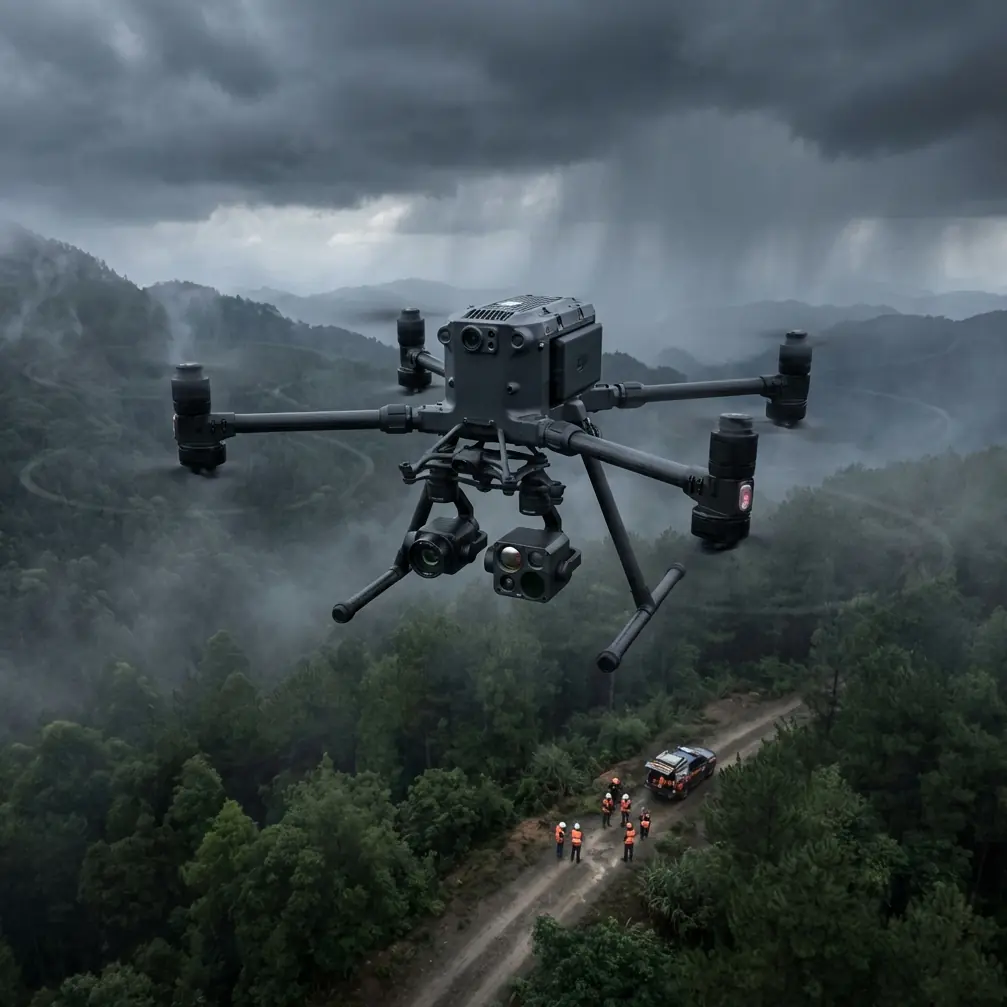
I have been looking at the Matrice 400 through the lens of one specific job: mapping a windy coastline where survey-grade repeatability matters more than headline specs. In that context, the conversation needs to include airframe behavior, photogrammetry discipline, link integrity, payload continuity, and even the kind of precision thinking that sits far below the level most operators ever discuss.
And yes, some of that precision can be traced back to old aircraft design fundamentals.
Why a coastline mission exposes the truth about an airframe
Coastal mapping is not just another corridor survey over flat land. The aircraft has to manage gusts coming off cliffs, unstable GNSS reflections near structures and wet surfaces, and constantly changing visual texture between wave wash, tidal flats, vegetation, and rock. A drone can look stable on paper and still produce compromised data when those variables stack up.
For the Matrice 400, the real value is not simply endurance or payload compatibility. It is how the system holds together as a mapping platform when conditions are no longer ideal. Photogrammetry along a shoreline depends on consistent overlap, stable camera attitude, clean triggering, and reliable command-and-control. If wind pushes the aircraft off line or causes repeated speed corrections, you do not just lose elegance in flight; you risk degraded model geometry, uneven ground sampling, and more cleanup work back at the workstation.
That is why I care about transmission resilience, battery management, encrypted links, and payload switching in the same breath. On a coast, they are not separate topics.
A mid-flight weather shift is where the Matrice 400 earns its keep
On one representative coastline scenario, the first leg began under manageable conditions. The sea surface had moderate chop, the sun angle was usable, and the planned photogrammetry run could proceed with standard overlap settings and GCP-backed control for downstream accuracy. Then the weather changed mid-flight.
A stronger onshore wind line developed faster than forecast. The aircraft started seeing more frequent lateral corrections over exposed sections of the coast, especially where cliffs funneled the airflow. This is the kind of moment that reveals whether a platform is merely capable or truly operational.
The Matrice 400’s strength in this situation is the way its ecosystem helps the operator preserve mission quality rather than simply salvage the flight. O3 transmission matters here because maintaining a robust downlink is not a luxury when sea spray, terrain irregularity, and changing orientation begin to work against signal quality. If you are flying farther from your launch point or planning with BVLOS frameworks in mind where regulations permit, command confidence becomes inseparable from data confidence.
Add AES-256 link security to that and the aircraft becomes easier to place into serious infrastructure and environmental workflows. Coastal mapping often intersects with ports, utilities, erosion management, habitat studies, and commercially sensitive shoreline assets. Secure transmission is not a box-ticking feature in those environments. It affects whether the platform can be integrated into enterprise operations at all.
The weather shift also sharpened the value of hot-swap batteries. Coastline missions rarely fail because one individual flight was impossible. They fail because operators lose continuity across multiple sorties. If wind forces a partial re-fly, battery turnaround speed becomes part of your data quality strategy. Hot-swap capability reduces dead time between segments and makes it more practical to maintain the same light window, tidal state, and environmental conditions across stitched datasets.
That continuity is worth more than many spec-sheet comparisons.
Photogrammetry over water-adjacent terrain needs discipline, not optimism
A Matrice 400 can carry a sophisticated sensor stack, but that does not protect you from bad survey design. Coastlines are one of the easiest places to collect attractive imagery and one of the hardest places to build clean, consistent mapping products.
The first operational principle is overlap conservatism. Wind and reflective surfaces create enough uncertainty that aggressive, minimal-overlap planning is hard to justify. The second is GCP placement. Ground control points are often harder to establish on active shorelines, but they become even more valuable when you are trying to reconcile sandy berms, rock faces, and constructed edges in one model. If the mission includes change detection between survey dates, GCP discipline stops being optional.
The Matrice 400 fits this environment well because it supports a professional workflow rather than a casual one. That includes switching from pure photogrammetry capture to thermal signature collection when the project scope expands. In coastal work, thermal is not just about “seeing heat.” It can assist with infrastructure inspection near waterfront facilities, identify moisture anomalies on built assets, and provide environmental context in dawn or dusk operations. Combining thermal signature data with visible-spectrum mapping in a single mission architecture is often more efficient than operators expect.
What matters is not the novelty of carrying multiple sensing tasks. It is whether the aircraft’s flight behavior and mission management allow you to do so without turning the survey into a patchwork compromise.
The hidden engineering lesson: tiny tolerances support big outcomes
Here is an angle most Matrice 400 articles miss.
The reference material behind this discussion includes a page from an aircraft design handbook listing standard steel ball sizes for rolling bearings. At first glance, that seems far removed from a modern UAV mission. It is not. The table includes values from extremely small diameters such as 0.3000 mm and 0.4000 mm all the way through larger imperial and metric equivalents like 1/8 inch at 3.1750 mm, 1/4 inch at 6.3500 mm, and 3/4 inch at 19.0500 mm.
Why should a Matrice 400 operator care?
Because precision airborne work rests on countless mechanical tolerances that most users never see. Bearings, rotating assemblies, gimbal axes, drivetrain components, and stabilization systems all depend on standardized dimensions and predictable quality. On a windy coastline, a mapping drone is constantly correcting for disturbance. Every clean yaw hold, every controlled pitch response, every stable gimbal recovery is made possible by mechanical systems that only perform well when underlying components are manufactured and matched to tight standards.
Those numbers from the handbook are not trivia. They are a reminder that repeatable survey results begin in hardware discipline. A platform designed for serious commercial work benefits from that culture of standardization, even if the pilot only experiences it as smoother footage, more stable image geometry, or fewer anomalies in processed outputs.
There is a second reference worth drawing into the picture: a weight and balance calculation page from another aircraft design volume. The source is partially degraded, but the visible numeric rows still show structured mass-property calculation logic, including values such as 220 with associated coefficients like 0.612, and another row with 238 and 0.654, alongside later figures such as 7.854 and 2.183. The precise line-item labels are obscured, but the operational significance is clear: aircraft performance depends on rigorous part-mass accounting and balance analysis, not broad estimates.
That matters directly for the Matrice 400.
When you fly a coastline mapping mission with different payload combinations, battery states, mounting options, or thermal-plus-visible configurations, center of gravity and mass distribution influence handling, efficiency, and stabilization margin. In calm air, an aircraft may mask imperfect loading. In wind, the penalties show up immediately through more aggressive control activity, shorter effective endurance, and less consistent sensor behavior. The old handbook logic still applies to the newest UAVs: precision mass modeling supports stable flight, and stable flight supports cleaner geospatial data.
O3 transmission is not just a range story
Many people reduce O3 transmission to a question of distance. That misses the operational point for coastline work.
Along a shore, you often deal with partial visual obstruction from terrain, changing antenna geometry as the aircraft tracks curved features, and multipath effects near metallic structures or water-facing infrastructure. A stronger transmission architecture helps preserve not only situational awareness but also mission discipline. If live video and telemetry remain dependable, the pilot can make informed adjustments when weather shifts, cloud shadow changes exposure conditions, or wave activity makes a low section of shoreline unsuitable for the original flight height.
That has a direct effect on photogrammetry quality. Better link confidence means fewer rushed control inputs and fewer broken survey lines. The result is often more consistent overlap and fewer processing headaches later.
If your operation needs help building that kind of mission profile around the aircraft, a direct technical conversation is often faster than reading generic setup notes. You can reach a specialist team here: message a Matrice 400 workflow advisor.
Battery strategy offshore is really a data strategy
Hot-swap batteries deserve more respect than they usually get.
On a coastline project, batteries do not simply determine airtime. They shape how well you can preserve environmental consistency across a multi-sortie mission. Tide movement, shifting sun angle, increasing wind, and transient human or vessel activity all change the scene. The longer the gap between flights, the harder it becomes to maintain uniformity in the dataset.
With hot-swap capability, the Matrice 400 is better positioned to keep operations moving while the rest of the system stays in rhythm: GCP references remain valid, the team can hold the same launch workflow, and data capture proceeds before the light changes too much. This becomes even more relevant when a mid-flight weather change forces you to break the mission into smaller windows and resume quickly between gust cycles.
A lot of “bad photogrammetry” is really bad timing.
Thermal signature and visual mapping: better together on coastal assets
Coastal projects increasingly blend terrain mapping with asset inspection. Seawalls, drainage outlets, rooflines near marine exposure, embankments, and utility interfaces all benefit from a layered dataset. The Matrice 400’s relevance rises when it is treated as a platform for that integrated workflow.
Visible imagery gives you geometry and surface condition. Thermal signature adds another dimension, especially for moisture ingress patterns, delamination cues, drainage issues, or heat-related anomalies on built structures. In windy coastal conditions, collecting both within a coordinated mission plan can save a second site mobilization and preserve comparable environmental context.
That only works if the aircraft remains manageable when the weather turns. Otherwise, operators end up postponing thermal, dropping overlap, or splitting missions in ways that complicate interpretation. The Matrice 400’s practical advantage is that it supports a more coherent capture sequence under pressure.
Should the Matrice 400 be trusted for windy coastline mapping?
For serious operators, yes, with one condition: treat it like a professional survey platform, not a flying camera.
Its value shows up when the mission demands more than basic image collection. O3 transmission supports link confidence in difficult coastal geometry. AES-256 aligns the aircraft with security expectations in enterprise environments. Hot-swap batteries improve continuity during narrow weather windows. Payload flexibility supports both photogrammetry and thermal signature objectives. And beneath all of that sits a truth older than the aircraft itself: airborne precision depends on mechanical standardization and disciplined mass balance.
That is why the obscure handbook details matter. A steel ball dimension like 3.1750 mm for a 1/8 inch standard, or 19.0500 mm for 3/4 inch, speaks to manufacturing order and repeatability. The weight-balance calculation logic hinted by values like 220, 0.612, 238, and 0.654 points to the engineering habit of quantifying stability rather than assuming it. In the field, those habits translate into steadier flight, cleaner sensor output, and a better chance of finishing the job when the wind rises halfway through the mission.
For coastline mapping, that is the difference between collecting data and collecting rework.
Ready for your own Matrice 400? Contact our team for expert consultation.