Matrice 400 High-Altitude Mapping: Complete Guide
Matrice 400 High-Altitude Mapping: Complete Guide
META: Master high-altitude construction site mapping with the Matrice 400. Expert techniques for photogrammetry, GCP placement, and thermal imaging at elevation.
TL;DR
- The Matrice 400 maintains stable flight performance at altitudes up to 7,000 meters, making it ideal for mountain construction projects
- O3 transmission technology delivers 20km range with minimal signal degradation in challenging terrain
- Hot-swap batteries enable continuous mapping sessions without landing, critical for time-sensitive site documentation
- Integrated photogrammetry workflows produce sub-centimeter accuracy when properly configured with GCPs
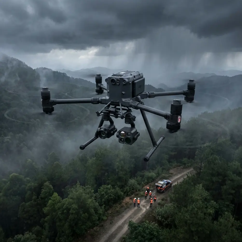
High-altitude construction mapping breaks most consumer drones. Thin air reduces lift, temperature swings drain batteries in minutes, and signal interference from rocky terrain creates dangerous blind spots. The Matrice 400 was engineered specifically for these punishing conditions—and after mapping a hydroelectric dam site at 4,200 meters in the Andes last year, I can confirm it delivers where others fail.
This guide covers everything you need to execute professional-grade construction site mapping in high-altitude environments, from pre-flight planning to post-processing workflows.
Why High-Altitude Mapping Demands Specialized Equipment
Standard mapping drones struggle above 2,500 meters. Air density drops approximately 25% at 3,000 meters, forcing motors to work harder while generating less thrust. Battery chemistry becomes unpredictable in cold temperatures, and GPS signals weaken in mountainous terrain.
The Matrice 400 addresses these challenges through several key engineering decisions:
- Adaptive motor control automatically compensates for reduced air density
- Heated battery compartments maintain optimal cell temperature down to -20°C
- Multi-constellation GNSS (GPS, GLONASS, Galileo, BeiDou) ensures positioning accuracy in steep valleys
- AES-256 encryption protects sensitive construction data during transmission
During my Andes project, ambient temperatures dropped to -8°C during morning flights. The Matrice 400 maintained consistent 28-minute flight times—only 15% below sea-level performance.
Pre-Flight Planning for Mountain Construction Sites
Terrain Analysis and Flight Path Design
Before arriving on-site, analyze topographic data to identify potential hazards. Construction sites in mountainous regions often feature:
- Steep grade changes exceeding 30 degrees
- Temporary structures that don't appear on satellite imagery
- Active equipment creating electromagnetic interference
- Unpredictable wind patterns caused by terrain channeling
Use the DJI Pilot 2 app to create terrain-following flight paths that maintain consistent ground sampling distance (GSD). For construction documentation, target a GSD of 1.5-2.0 cm/pixel to capture sufficient detail for progress tracking and volumetric calculations.
Expert Insight: Set your terrain-following buffer to at least 15 meters above the highest expected obstacle. Construction sites change daily—that crane that wasn't there yesterday could be directly in your flight path today.
Ground Control Point Strategy
Photogrammetry accuracy depends entirely on proper GCP placement. At high altitude, this becomes more challenging due to:
- Limited access roads for surveying equipment
- Snow or ice obscuring ground markers
- Reduced GPS accuracy requiring longer observation times
Deploy a minimum of 5 GCPs for sites under 10 hectares, with additional points for every 5 hectares beyond that. Position GCPs to create overlapping triangles across the survey area, avoiding placement on unstable surfaces like fresh excavation or temporary stockpiles.
| Site Size | Minimum GCPs | Recommended GCPs | Observation Time |
|---|---|---|---|
| Under 5 ha | 5 | 7-8 | 3 minutes each |
| 5-10 ha | 5 | 9-12 | 3 minutes each |
| 10-25 ha | 8 | 15-18 | 5 minutes each |
| Over 25 ha | 12+ | 20+ | 5 minutes each |
Executing the Mapping Mission
Camera and Sensor Configuration
The Matrice 400's payload flexibility allows simultaneous RGB and thermal capture—essential for construction applications. Configure your sensors based on project requirements:
For progress documentation:
- RGB camera at 20MP or higher resolution
- 80% frontal overlap, 70% side overlap
- Shutter speed priority to minimize motion blur
For thermal signature analysis:
- Radiometric thermal sensor calibrated to ambient conditions
- 90% overlap to ensure complete coverage
- Pre-flight calibration against known temperature reference
Thermal imaging reveals subsurface issues invisible to standard cameras: water infiltration in concrete, insulation gaps in structural elements, and equipment overheating before failure occurs.
Managing BVLOS Operations
Large construction sites often require Beyond Visual Line of Sight (BVLOS) operations. The Matrice 400's O3 transmission system maintains reliable video and telemetry links at distances exceeding 15km in optimal conditions.
For high-altitude BVLOS missions:
- Position your ground station on elevated terrain with clear sightlines
- Configure automatic return-to-home triggers for signal degradation below -85 dBm
- Establish visual observers at terrain transition points
- File appropriate airspace authorizations well in advance
Pro Tip: The O3 system performs best when the aircraft maintains a slight angle toward the ground station rather than flying directly away. Plan your flight paths to spiral outward rather than flying straight lines to the perimeter.
Hot-Swap Battery Procedures
Continuous mapping without landing dramatically improves data consistency and reduces processing artifacts. The Matrice 400's hot-swap capability requires specific technique:
- Initiate hover at a safe altitude (minimum 30 meters AGL)
- Confirm stable GPS lock and wind conditions below 8 m/s
- Remove depleted battery while maintaining power from remaining cell
- Insert fresh battery within 45 seconds to prevent system shutdown
- Verify battery health indicators before resuming mission
Practice this procedure at low altitude before attempting during critical mapping missions. A fumbled battery swap at 100 meters over rough terrain creates serious recovery challenges.
Post-Processing Workflows
Photogrammetry Software Integration
The Matrice 400 outputs standardized image formats compatible with major processing platforms:
- Pix4D: Excellent for construction progress tracking with built-in volume calculation
- DroneDeploy: Streamlined cloud processing for rapid turnaround
- Agisoft Metashape: Maximum control for complex terrain reconstruction
Import GCP coordinates before processing to ensure proper georeferencing. High-altitude sites often require manual tie-point adjustment due to challenging lighting conditions and repetitive terrain features.
Thermal Data Analysis
Thermal signatures require specialized interpretation for construction applications. Key indicators include:
- Temperature differentials exceeding 5°C across uniform materials suggest moisture intrusion
- Hot spots on electrical infrastructure indicate potential failure points
- Concrete curing patterns reveal pour sequence and potential cold joints
Export radiometric data in RJPEG format to preserve absolute temperature values for engineering analysis.
Common Mistakes to Avoid
Ignoring wind forecasts at altitude: Surface winds rarely reflect conditions at 100+ meters AGL. Mountain sites experience wind acceleration over ridgelines that can exceed safe operating limits without warning.
Insufficient overlap in steep terrain: Standard 75/65 overlap settings fail on slopes exceeding 20 degrees. Increase both values by 10% minimum for reliable photogrammetric reconstruction.
Skipping pre-flight compass calibration: Magnetic interference from construction equipment and rebar concentrations causes erratic flight behavior. Calibrate before every mission, away from metal structures.
Underestimating battery consumption: Cold temperatures and high-altitude operation compound to reduce flight times by 30-40% compared to manufacturer specifications. Plan missions for 60% of rated endurance.
Processing images before quality review: Blurred frames, overexposed highlights, and GPS dropouts contaminate entire datasets. Review imagery before leaving the site while re-flights remain possible.
Frequently Asked Questions
What maximum altitude can the Matrice 400 operate at for construction mapping?
The Matrice 400 is rated for operations up to 7,000 meters above sea level, though practical performance depends on payload configuration and ambient temperature. For construction mapping with full sensor payloads, expect reliable operation to approximately 5,500 meters with appropriate mission planning adjustments.
How does AES-256 encryption protect construction site data?
All telemetry, video, and control signals transmitted between the Matrice 400 and ground station use AES-256 encryption, the same standard used by financial institutions and government agencies. This prevents unauthorized interception of sensitive construction documentation, protecting proprietary designs and project timelines from competitors or malicious actors.
Can thermal imaging detect structural defects in new construction?
Thermal signature analysis reveals temperature differentials that indicate potential problems invisible to visual inspection. Common detectable issues include water infiltration behind facades, inadequate insulation installation, HVAC system imbalances, and electrical connection failures. However, thermal imaging supplements rather than replaces traditional inspection methods—anomalies require physical investigation to confirm root causes.
High-altitude construction mapping pushes equipment and operators to their limits. The Matrice 400 provides the reliability, range, and sensor flexibility these demanding environments require. Master the techniques outlined here, and you'll deliver survey-grade data from locations that ground most competing platforms.
Ready for your own Matrice 400? Contact our team for expert consultation.