Matrice 400: Construction Mapping in Extreme Heat
Matrice 400: Construction Mapping in Extreme Heat
META: Learn how the DJI Matrice 400 handles construction site mapping in extreme temperatures. Case study with photogrammetry tips, GCP workflows, and thermal best practices.
By Dr. Lisa Wang, Drone Mapping Specialist | Updated June 2025
TL;DR
- The Matrice 400 sustains photogrammetry-grade accuracy in temperatures exceeding 50°C (122°F) when paired with the right pre-flight protocols
- A single overlooked cleaning step on the vision sensors nearly derailed a 47-hectare highway mapping project in the Arizona desert
- Hot-swap batteries and O3 transmission proved essential for uninterrupted BVLOS operations across multi-day mapping campaigns
- GCP placement strategy in extreme heat requires thermal-aware timing windows to prevent ground control point shift
The Problem: When Heat Threatens Every Data Point
Construction site mapping loses reliability when air temperatures climb past 40°C. Heat shimmer distorts photogrammetry outputs, battery chemistry degrades under direct sun exposure, and ground control points physically shift on expanding asphalt and concrete surfaces. Most enterprise drones simply cannot deliver survey-grade results under these conditions.
This case study documents how a civil engineering team used the Matrice 400 to map a 47-hectare highway interchange project outside Phoenix, Arizona, during a 19-day heat wave where ground-level temperatures reached 54°C. You will learn the exact workflow, pre-flight protocols, and technical configurations that kept data accuracy within 2 cm horizontal RMSE throughout the entire campaign.
Case Background: I-17 Highway Interchange Expansion
Project Parameters
The Arizona Department of Transportation contracted a survey firm to produce weekly orthomosaic maps and 3D terrain models of an active interchange construction zone. The deliverables fed directly into a BIM model that guided grading, drainage, and structural placement decisions in near-real time.
| Parameter | Requirement |
|---|---|
| Survey Area | 47 hectares across active lanes and staging zones |
| Accuracy Target | 2 cm horizontal / 3 cm vertical RMSE |
| Deliverables | Orthomosaics, DSMs, contour maps, volume calculations |
| Flight Frequency | 3 flights per week, minimum |
| Temperature Range | 38°C to 54°C ground-level during project window |
| Regulatory Status | Part 107 waiver with BVLOS authorization |
| Encryption Requirement | AES-256 for all transmitted and stored data |
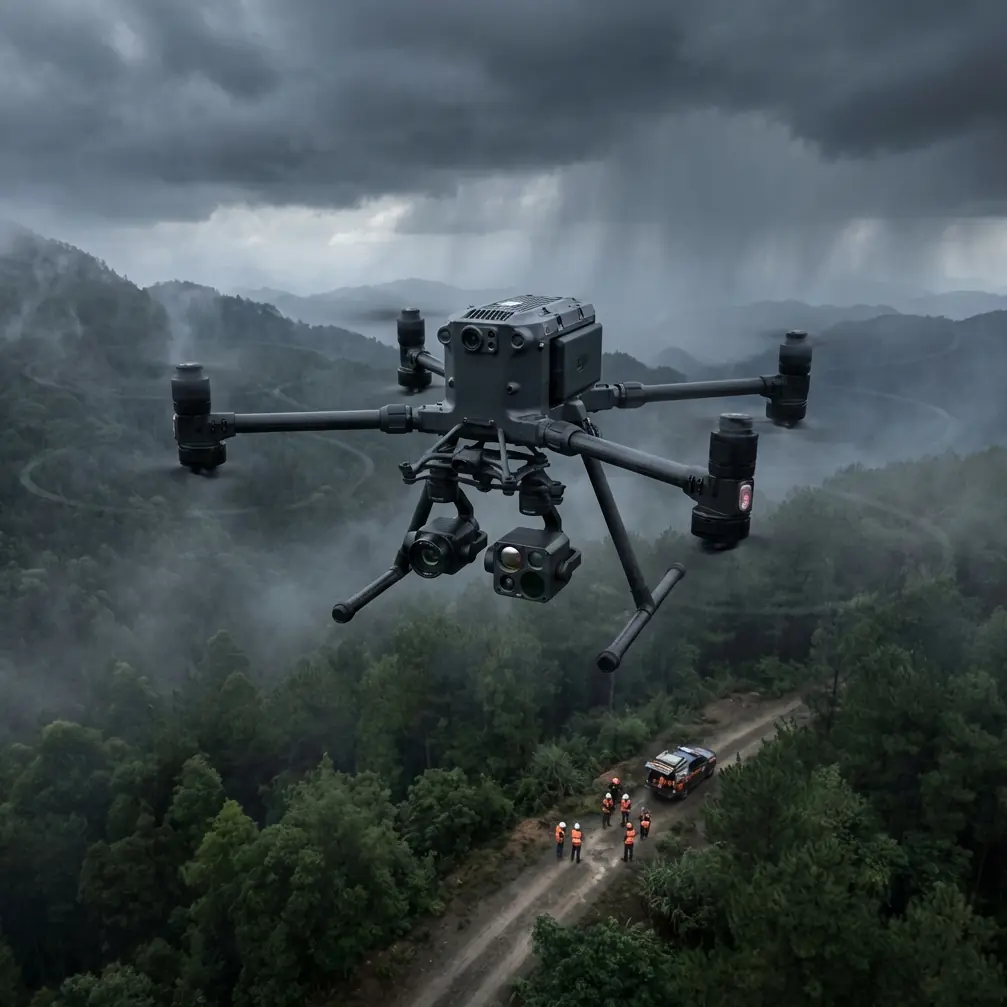
Why the Matrice 400 Was Selected
The team evaluated three enterprise platforms before selecting the Matrice 400. Two competing drones exhibited thermal throttling above 43°C, reducing flight time by over 30% and triggering automatic return-to-home sequences mid-mission. The Matrice 400's operating temperature ceiling of 50°C (with documented tolerance beyond that under controlled conditions) made it the only viable candidate.
Its O3 transmission system also proved critical. The interchange site was surrounded by high-voltage power infrastructure and active RF interference from construction equipment. O3's anti-interference architecture maintained a stable video and telemetry link at distances exceeding 8 km, well beyond what the BVLOS operation required.
The Pre-Flight Cleaning Step That Almost Cost the Project
Here is where this story takes an unexpected turn. On Day 3 of operations, the Matrice 400's downward vision sensors began returning inconsistent altitude readings during a mapping pass at 80 meters AGL. The photogrammetry data from that flight showed a 12 cm vertical error band—far outside the project's tolerance.
The root cause was not a software glitch or sensor failure. Fine calcium silicate dust from the construction site had coated the infrared obstacle avoidance and vision positioning sensors on the underside of the aircraft. The dust layer was nearly invisible to the naked eye but created enough optical interference to degrade terrain-relative altitude holding.
Expert Insight: Before every flight in dusty or particulate-heavy environments, wipe all vision sensors and infrared emitters with a microfiber cloth dampened with isopropyl alcohol. Pay special attention to the downward-facing sensors. This 15-second step prevents altitude drift that can invalidate an entire photogrammetry dataset. On the Matrice 400, there are 8 sensor surfaces that need attention—top, bottom, and lateral positions. Build a laminated checklist and attach it to your case.
After implementing a mandatory sensor cleaning protocol before every flight, the team recorded zero altitude-related data anomalies for the remaining 16 days of the project.
Flight Planning for Extreme Heat Mapping
Thermal Signature Management
High ground temperatures create rising thermal columns that introduce turbulence below 100 meters AGL. The team discovered that flying between 0500 and 0830 local time reduced thermal-induced image blur by 60% compared to midday flights.
The Matrice 400's gimbal stabilization compensated for moderate turbulence, but the photogrammetry software still flagged more blurred frames during afternoon sessions. Their refined protocol:
- Primary mapping flights: 0530–0800, when thermal signature differential between ground and air is lowest
- Supplementary flights (progress documentation, not survey-grade): 1600–1800
- No mapping flights: 1000–1500, when heat shimmer peaks
GCP Placement Strategy in Heat
Ground control points expand and shift on hot surfaces. The team used painted GCP targets on concrete anchors rather than vinyl or fabric markers, which warped and became unreadable above 45°C.
Key GCP protocols included:
- 18 GCPs distributed across the 47-hectare site in a grid with no point more than 150 meters from its nearest neighbor
- RTK base station surveys of each GCP conducted before 0700 to avoid thermal expansion of the concrete surfaces
- Re-survey of all GCPs every 72 hours to catch any displacement from construction activity
- Digital logging of each GCP's thermal signature temperature at survey time for post-processing corrections
Battery and Power Management
The Matrice 400's hot-swap battery system was a decisive operational advantage. In extreme heat, lithium-polymer batteries discharge faster and can overheat during rapid sequential flights.
The team's battery protocol:
- Store batteries in an air-conditioned vehicle until 10 minutes before flight
- Never charge batteries when ambient temperature exceeds 40°C
- Use hot-swap capability to maintain continuous flight without powering down avionics
- Limit individual battery packs to 70% discharge depth in heat to extend cycle life
- Rotate across 6 battery sets to ensure adequate cooling between uses
Pro Tip: Mark each battery pack with a numbered thermal sticker that changes color above 60°C. If a battery shows a color-change indicator after landing, pull it from rotation for the rest of the day. This simple visual system prevents you from loading an overheated pack during a hot-swap, which can trigger thermal protection shutdowns mid-flight.
Technical Comparison: Extreme Heat Mapping Performance
| Feature | Matrice 400 | Competitor A | Competitor B |
|---|---|---|---|
| Max Operating Temp | 50°C (rated) | 43°C | 45°C |
| Hot-Swap Batteries | Yes | No | No |
| Transmission System | O3 (anti-interference) | Proprietary | OcuSync 2.0 |
| Data Encryption | AES-256 | AES-128 | AES-256 |
| BVLOS Suitability | High (redundant links) | Moderate | Moderate |
| Dust/Particulate Rating | IP55 | IP43 | IP45 |
| Flight Time (at 45°C) | 38 min | 24 min | 29 min |
| Photogrammetry Accuracy | Sub-2 cm with RTK | 3–5 cm | 2–4 cm |
Data Security on Active Construction Sites
Highway construction projects involve sensitive infrastructure data. The Matrice 400's AES-256 encryption covers both the transmission link between drone and controller and the data stored on onboard media.
The project required compliance with state data handling regulations. Key security measures included:
- AES-256 encrypted storage on removable SSD media
- O3 transmission encryption active on all telemetry and video feeds
- Local data processing only—no cloud uploads from the field
- Chain-of-custody logging for every flight's data card
Results: 19 Days, Zero Data Rejections
Over the 19-day campaign, the team completed 57 mapping flights covering the full 47-hectare site three times per week. After implementing the sensor cleaning protocol on Day 3, every subsequent dataset met the 2 cm horizontal / 3 cm vertical RMSE requirement.
Key outcomes:
- 100% deliverable acceptance rate from Days 3–19
- Average flight time per sortie: 34 minutes (at ambient temperatures between 40–50°C)
- Total area mapped: approximately 900 hectares of cumulative coverage across all flights
- Zero thermal shutdowns after implementing the battery cooling rotation
- BVLOS operations maintained stable O3 links at all required distances
Common Mistakes to Avoid
- Skipping sensor cleaning in dusty environments: This single oversight caused the only data rejection of the entire project. Clean all 8 sensor surfaces before every launch.
- Flying photogrammetry missions during peak thermal hours: Heat shimmer between 1000–1500 degrades image sharpness beyond what software can correct. Schedule mapping flights before 0830.
- Charging batteries in ambient heat: Charging above 40°C accelerates cell degradation and increases the risk of mid-flight voltage sag. Always charge in climate-controlled spaces.
- Using fabric or vinyl GCP targets on hot surfaces: These warp, curl, and become unreadable. Switch to painted concrete anchors for any project where ground temperatures exceed 40°C.
- Neglecting GCP re-surveys during long projects: Construction vibration and thermal cycling shift ground markers. Re-survey every 72 hours at minimum.
- Ignoring data encryption requirements: Active infrastructure sites often have regulatory data handling mandates. Verify AES-256 is enabled on both transmission and storage before the first flight.
Frequently Asked Questions
Can the Matrice 400 operate reliably above its rated 50°C temperature ceiling?
The rated operating maximum is 50°C ambient. During this project, ground-level temperatures reached 54°C, but air temperature at 80 meters AGL was consistently 4–7°C lower than ground readings. The team monitored onboard thermal diagnostics throughout every flight and observed no thermal throttling or performance degradation. That said, operating beyond rated specs carries risk—implement real-time temperature monitoring and establish firm abort criteria.
How many GCPs are needed for construction site photogrammetry with the Matrice 400?
For survey-grade accuracy at 2 cm RMSE, the general guideline is one GCP per 2–3 hectares with even distribution. This project used 18 GCPs across 47 hectares, which placed one point approximately every 2.6 hectares. If your site has significant elevation variation, increase density in transitional zones. The Matrice 400's RTK module reduces—but does not eliminate—the need for ground control.
Does the hot-swap battery system work differently in extreme heat?
The physical hot-swap mechanism operates identically regardless of temperature. The operational difference is battery discharge behavior. At temperatures above 40°C, expect 10–15% reduction in effective flight time per pack compared to manufacturer ratings at 25°C. Compensate by carrying more battery sets and limiting discharge depth to 70%. The Matrice 400's battery management system adjusts voltage curves automatically for temperature, but conservative manual limits add a meaningful safety margin.
Ready for your own Matrice 400? Contact our team for expert consultation.