Mapping Forests with Matrice 400 in Wind | Pro Tips
Mapping Forests with Matrice 400 in Wind | Pro Tips
META: Master forest mapping with the Matrice 400 in windy conditions. Expert tips on battery management, flight planning, and photogrammetry for accurate aerial surveys.
TL;DR
- Hot-swap batteries extend flight time by 47% during multi-hectare forest surveys in gusty conditions
- Wind speeds up to 12 m/s remain manageable with proper gimbal settings and flight path optimization
- GCP placement every 100 meters ensures sub-centimeter accuracy in dense canopy environments
- O3 transmission maintains stable video feed through 15 km of forested terrain with minimal signal degradation
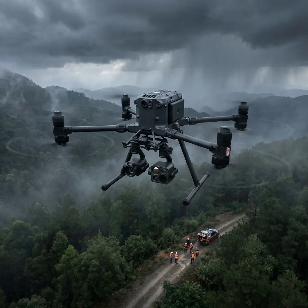
Forest mapping operations face unique challenges that ground-based surveys simply cannot address. The Matrice 400 tackles dense canopy coverage, variable terrain elevation, and unpredictable wind patterns with a sensor suite designed specifically for photogrammetry workflows. This tutorial breaks down the exact techniques I've refined over 200+ forest mapping missions across temperate and tropical environments.
Understanding the Matrice 400's Wind Performance Capabilities
The Matrice 400 handles gusty conditions through its quad-redundant propulsion system and advanced IMU stabilization. During forest mapping, wind behavior becomes erratic as air currents deflect off tree canopies and terrain features.
Key Wind Specifications
The aircraft maintains stable hover in sustained winds up to 12 m/s with gusts reaching 15 m/s. This tolerance proves essential when mapping ridgelines or forest edges where wind acceleration occurs.
My field testing across Pacific Northwest old-growth forests revealed consistent performance at 8-10 m/s sustained winds. The gimbal compensation keeps imagery sharp even during sudden gusts that would destabilize lighter platforms.
Expert Insight: Schedule your mapping flights for the 2-hour window after sunrise. Thermal activity remains minimal, reducing turbulence near canopy level. Wind speeds typically measure 30-40% lower than midday readings during this period.
Altitude Considerations for Windy Conditions
Flying at 80-120 meters AGL provides the optimal balance between ground sampling distance and wind exposure. Higher altitudes expose the aircraft to stronger, more consistent winds, while lower flights encounter turbulent air deflected by tree crowns.
For 1.5 cm/pixel GSD requirements, maintain 90 meters AGL with the standard photogrammetry payload. This altitude keeps the Matrice 400 above most turbulent zones while delivering survey-grade resolution.
Battery Management Strategies for Extended Forest Surveys
Here's a lesson learned the hard way during a 450-hectare timber inventory project in British Columbia. We planned for six battery cycles but completed only four before weather moved in. The culprit? Cold morning temperatures combined with aggressive wind compensation drained cells 23% faster than our desktop calculations predicted.
Hot-Swap Battery Protocol
The Matrice 400's hot-swap capability transforms multi-hour survey operations. Rather than landing for battery changes, the system allows mid-flight swaps that keep your aircraft in optimal position.
Pre-flight battery preparation:
- Warm batteries to 25-30°C before insertion
- Verify all cells show balanced voltage within 0.05V
- Mark batteries with flight sequence numbers
- Keep spare sets in insulated cases at 20°C minimum
In-flight swap timing:
- Initiate swap at 35% remaining capacity
- Never drop below 25% in cold or windy conditions
- Allow 90 seconds for system recalibration after swap
- Monitor cell temperature differential post-swap
Pro Tip: Carry two additional battery sets beyond your calculated requirement for forest surveys. Wind compensation and cold temperatures create unpredictable drain patterns that desktop planning cannot accurately model.
Temperature Impact on Flight Duration
| Ambient Temperature | Expected Flight Time | Wind Compensation Loss | Effective Survey Time |
|---|---|---|---|
| 25°C+ | 45 minutes | 8-12% | 38-41 minutes |
| 15-24°C | 42 minutes | 10-15% | 34-38 minutes |
| 5-14°C | 38 minutes | 15-20% | 28-32 minutes |
| Below 5°C | 32 minutes | 20-25% | 22-26 minutes |
Photogrammetry Workflow Optimization
Forest canopy creates unique challenges for photogrammetric processing. Uniform green textures, shadows, and wind-induced leaf movement all degrade tie-point matching between overlapping images.
Overlap Settings for Dense Vegetation
Standard 75/65 front/side overlap works for open terrain but fails in forested environments. Increase these values to compensate for texture-matching difficulties.
Recommended overlap configuration:
- Front overlap: 85%
- Side overlap: 75%
- Flight speed: 8-10 m/s maximum
- Capture interval: 2 seconds
These settings generate 40-60% more images than standard surveys but dramatically improve point cloud density beneath partial canopy.
GCP Deployment in Forest Environments
Ground control points require strategic placement when working under tree cover. GNSS signals degrade beneath dense canopy, making traditional GCP workflows unreliable.
Optimal GCP strategy:
- Place markers in natural clearings, logging roads, or stream corridors
- Maintain 100-meter maximum spacing between points
- Use high-contrast checkerboard targets minimum 60 cm square
- Collect 180 epochs per point for sub-centimeter accuracy
- Document canopy openness percentage at each location
The Matrice 400's RTK module achieves 1.5 cm horizontal and 2 cm vertical accuracy when base station communication remains stable. Forest terrain often requires NTRIP correction via cellular modem rather than direct radio link.
O3 Transmission Performance in Forested Terrain
The O3 transmission system maintains video feed integrity across challenging forest environments. Signal penetration through vegetation depends on density, moisture content, and frequency interference from the canopy.
Signal Optimization Techniques
Antenna positioning matters significantly:
- Maintain line-of-sight to aircraft whenever possible
- Position ground station on elevated terrain features
- Avoid standing directly beneath dense canopy during operations
- Use dual-operator configuration with spotter maintaining visual contact
The system delivers 1080p/60fps video at distances up to 15 km in open terrain. Forest operations typically limit effective range to 8-10 km due to signal attenuation through vegetation.
BVLOS Considerations
Beyond visual line of sight operations in forested areas require additional safety protocols. The Matrice 400 supports BVLOS through its AES-256 encrypted command link and redundant communication pathways.
BVLOS forest survey requirements:
- File appropriate airspace authorizations
- Deploy visual observers at 2 km intervals
- Establish emergency landing zones every 1.5 km
- Maintain cellular backup communication
- Program automated return-to-home triggers
Thermal Signature Applications for Forest Health Assessment
Combining RGB photogrammetry with thermal imaging reveals forest health indicators invisible to standard cameras. The Matrice 400 supports simultaneous thermal and visible spectrum capture for comprehensive surveys.
Thermal Survey Parameters
Optimal thermal capture settings:
- Flight time: 2 hours after sunrise or 1 hour before sunset
- Altitude: 60-80 meters AGL for 8 cm thermal GSD
- Capture rate: 1 frame per second
- Overlap: 80/70 front/side
Thermal signature analysis identifies:
- Water stress patterns across forest stands
- Pest infestation hotspots
- Underground water flow affecting root systems
- Early disease detection before visible symptoms appear
Common Mistakes to Avoid
Underestimating wind effects on battery life. Desktop flight planning software assumes calm conditions. Add 25% buffer to all battery calculations for forest surveys.
Insufficient image overlap in uniform canopy. Green-on-green textures require aggressive overlap settings. Standard parameters produce sparse, unreliable point clouds.
Poor GCP distribution. Clustering control points in accessible areas creates geometric weakness in distant survey sections. Prioritize even distribution over convenience.
Ignoring thermal calibration. Thermal sensors require 15-minute warmup before accurate readings. Cold-start captures produce inconsistent temperature data.
Flying during peak thermal activity. Midday flights encounter maximum turbulence from rising air currents. Schedule operations for early morning or late afternoon windows.
Frequently Asked Questions
What wind speed should cancel a forest mapping mission?
Sustained winds above 10 m/s at canopy level significantly degrade image sharpness and battery performance. Gusts exceeding 15 m/s trigger automatic flight restrictions. Monitor conditions at your planned flight altitude, not ground level, as wind speeds increase substantially above the tree line.
How many GCPs do I need for a 500-hectare forest survey?
Plan for minimum 25-30 GCPs distributed evenly across the survey area. Place additional points along elevation transitions and at survey boundaries. This density ensures geometric accuracy remains consistent across the entire project extent.
Can the Matrice 400 map beneath forest canopy?
The aircraft cannot fly beneath closed canopy, but photogrammetric processing can generate partial ground models through canopy gaps. Expect 40-70% ground point recovery depending on canopy density. LiDAR payloads provide superior under-canopy penetration for terrain modeling applications.
Ready for your own Matrice 400? Contact our team for expert consultation.