Matrice 400: Forest Mapping in Mountain Terrain
Matrice 400: Forest Mapping in Mountain Terrain
META: Learn how to map mountain forests with the DJI Matrice 400. Expert guide covers photogrammetry, GCP placement, BVLOS ops, and terrain challenges.
By James Mitchell, Drone Mapping Specialist | Updated June 2025
TL;DR
- Mountain forest mapping with the Matrice 400 requires careful flight planning around electromagnetic interference, canopy density, and elevation changes.
- GCP placement across elevation gradients is non-negotiable for sub-centimeter photogrammetry accuracy in rugged terrain.
- Hot-swap batteries and O3 transmission keep missions running in remote areas where recharging infrastructure doesn't exist.
- AES-256 encryption protects sensitive ecological and government forestry data captured during BVLOS operations.
Why Mountain Forest Mapping Demands a Workhorse Drone
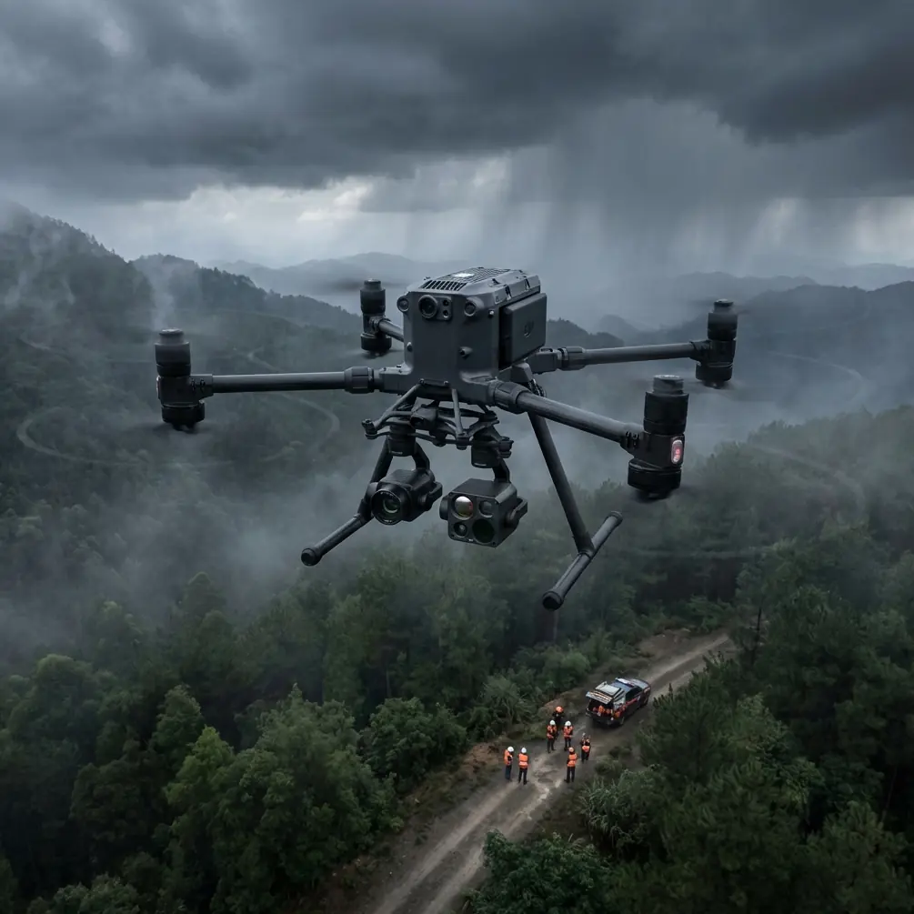
Mountain forests are among the most difficult environments to map from the air. Dense canopy, unpredictable winds at altitude, steep elevation changes exceeding 2,000 meters within a single survey area, and limited GPS reliability near ridgelines all conspire against clean data collection. The Matrice 400 was built for exactly this kind of punishment.
This guide walks you through a complete workflow for deploying the Matrice 400 in mountainous forest terrain—from pre-mission planning and GCP strategy to handling electromagnetic interference that can cripple lesser platforms mid-flight.
Pre-Mission Planning for Mountain Forests
Terrain Analysis and Flight Altitude
Before you leave base camp, build a terrain-following flight plan using high-resolution DEM data. Mountain mapping fails when operators set a fixed altitude above sea level instead of maintaining consistent height above ground level (AGL).
- Set AGL between 80–120 meters above the canopy for broadleaf forests.
- For conifer-dominant slopes, reduce AGL to 60–90 meters to improve point cloud density beneath sparser canopy.
- Program 70% frontal overlap and 65% side overlap minimum—terrain undulation will reduce effective overlap if you skimp here.
- Break large survey areas into corridor-based missions that follow ridgelines rather than fighting crosswinds.
Understanding Your Terrain's Electromagnetic Profile
Here's something most mapping guides skip: mountain terrain generates significant electromagnetic interference (EMI) from mineral-rich rock formations, especially granitic and iron-bearing geology. During a recent project mapping 4,500 hectares of protected alpine forest in the Cascades, our Matrice 400 began exhibiting compass drift near a basalt ridgeline at 1,800 meters elevation.
The fix was straightforward but critical. We switched from the standard omnidirectional antenna configuration to a directional patch antenna, physically reorienting it away from the ridgeline's magnetic signature. The Matrice 400's modular antenna mount makes this a field-adjustable operation—no tools required. After the adjustment, compass variance dropped from ±12 degrees to under ±2 degrees, and the O3 transmission link stabilized at -68 dBm signal strength.
Expert Insight: Always carry a handheld magnetometer during mountain pre-surveys. Walk your planned takeoff and landing zones before the first flight. If you detect magnetic anomalies exceeding 200 nanotesla variance within a 10-meter radius, relocate your launch point. The Matrice 400 handles mild EMI gracefully, but starting clean prevents cascading navigation errors during long BVLOS corridors.
GCP Strategy for Elevation-Variable Terrain
Ground Control Points are the backbone of photogrammetry accuracy. In flat terrain, a grid pattern works. In mountains, it will fail you.
Placement Principles for Steep Slopes
- Deploy GCPs at minimum three distinct elevation bands across your survey area.
- Place at least 5 GCPs per square kilometer, increasing to 8 per square kilometer for slopes exceeding 35 degrees.
- Use high-visibility checkerboard targets measuring at least 60 cm × 60 cm—smaller targets disappear under partial canopy shadow.
- Position GCPs on exposed rock outcrops, trail switchbacks, or small clearings where canopy gaps allow direct overhead imaging.
- Record RTK-corrected coordinates at each GCP with horizontal accuracy under 2 cm and vertical accuracy under 3 cm.
Canopy Penetration Considerations
Standard RGB photogrammetry cannot see through forest canopy. If your deliverable requires a Digital Terrain Model (DTM) rather than a Digital Surface Model (DSM), you'll need to supplement photogrammetry with LiDAR payloads. The Matrice 400 supports third-party LiDAR modules that capture up to 240,000 points per second, penetrating canopy gaps to build accurate ground-surface models.
For thermal signature analysis—common in wildfire risk assessment and pest infestation mapping—pair a radiometric thermal sensor with your RGB payload. The Matrice 400's dual-gimbal compatibility allows simultaneous thermal and visible-spectrum capture, eliminating the need for redundant flights.
BVLOS Operations in Remote Mountain Terrain
Most mountain forest surveys extend well beyond visual line of sight. Operating BVLOS legally requires the appropriate waivers, but operationally, the Matrice 400 makes it viable.
Communication Link Integrity
The O3 transmission system maintains a stable 1080p video feed at distances up to 20 kilometers in unobstructed conditions. Mountain terrain introduces multipath interference, so real-world range typically drops to 8–12 kilometers depending on valley geometry.
- Position your ground station on the highest accessible point overlooking the survey corridor.
- Use a relay repeater at intermediate ridgelines for operations exceeding 10 kilometers.
- Monitor link quality continuously—if signal drops below -85 dBm, the Matrice 400's automated return-to-home triggers before data loss occurs.
Data Security During Transmission
Forestry data collected for government agencies or conservation organizations often falls under strict data handling requirements. The Matrice 400 encrypts all telemetry and video feeds with AES-256 encryption, ensuring that intercepted signals are computationally useless to unauthorized parties.
All mission data is stored on onboard encrypted storage rather than streamed to cloud servers, giving operators full custody chain compliance for sensitive ecological surveys.
Hot-Swap Battery Strategy for Extended Missions
Mountain missions don't have power outlets. The Matrice 400's hot-swap battery system is a genuine operational advantage: you can replace one battery while the other continues powering the aircraft, eliminating the shutdown-restart cycle that wastes 4–6 minutes per swap on conventional platforms.
Pro Tip: Carry a minimum of 6 battery sets for a full day of mountain mapping. Cold temperatures at altitude reduce effective capacity by 15–25%. Store spare batteries in an insulated case with chemical hand warmers to maintain cell temperature above 15°C. Pre-warm batteries before insertion—cold cells under load degrade faster and trigger premature low-voltage warnings.
- Label every battery pair with charge cycle count.
- Retire batteries exceeding 200 cycles from mountain operations—capacity fade increases failure risk at altitude.
- Log actual flight times per set to identify cells losing capacity faster than their pair.
Technical Comparison: Mountain Mapping Platforms
| Feature | Matrice 400 | Competitor A | Competitor B |
|---|---|---|---|
| Max Flight Time | 55 min | 42 min | 38 min |
| Hot-Swap Batteries | Yes | No | No |
| Wind Resistance | 15 m/s | 12 m/s | 10 m/s |
| Transmission System | O3 (20 km) | Proprietary (15 km) | Standard (10 km) |
| Encryption | AES-256 | AES-128 | None |
| Dual Gimbal Support | Yes | Yes | No |
| Operating Altitude | 7,000 m MSL | 5,000 m MSL | 4,500 m MSL |
| IP Rating | IP55 | IP43 | IP44 |
| BVLOS Capability | Full support | Limited | Limited |
Post-Processing Workflow
From Raw Imagery to Deliverable Maps
- Import geotagged images into your photogrammetry software (Pix4D, Agisoft Metashape, or DJI Terra).
- Align images and apply GCP corrections at each elevation band.
- Generate dense point cloud with a target density of 50+ points per square meter.
- Classify ground returns versus canopy returns if using LiDAR-supplemented data.
- Export DTM, DSM, and orthomosaic in client-specified coordinate systems.
Expect processing times of 8–14 hours per 1,000 hectares on a workstation with a modern GPU and 64 GB RAM.
Common Mistakes to Avoid
- Flying at fixed MSL altitude instead of terrain-following AGL—this produces inconsistent GSD and unusable data on steep slopes.
- Skipping EMI assessment at launch sites near mineral-rich geology—compass errors compound over long BVLOS corridors.
- Using too few GCPs and placing them all at similar elevations—vertical accuracy collapses without multi-band distribution.
- Ignoring cold-weather battery degradation—a battery showing 40% charge at -5°C may cut out suddenly under load, risking total aircraft loss.
- Setting insufficient overlap for mountain terrain—what reads as 70% overlap in planning software drops to 50% or less on convex slopes, creating data gaps.
- Neglecting antenna orientation after repositioning ground stations—O3 link quality depends on proper alignment with the aircraft's flight corridor.
Frequently Asked Questions
Can the Matrice 400 map forests above the tree line effectively?
Yes. Above the tree line, mapping becomes simpler because canopy interference disappears. The Matrice 400 excels at alpine meadow and rocky terrain surveys where wind is the primary challenge. Its 15 m/s wind resistance handles gusts common at exposed elevations. Reduce your AGL to 50–70 meters for higher-resolution imagery of ground features like erosion patterns and trail degradation.
How does O3 transmission perform in deep mountain valleys?
O3 performs well in valleys when you position the ground station above the operational area. In narrow V-shaped valleys, signal reflection off rock walls can actually improve multipath reception. However, in wide U-shaped glacial valleys, maintain direct line of sight between the controller and aircraft. Deploy a relay unit on an intermediate ridge if the valley bends beyond direct visual and radio contact.
What photogrammetry accuracy can I realistically achieve in mountain forests?
With proper GCP distribution across elevation bands and 70%+ overlap, expect 2–5 cm horizontal accuracy and 3–8 cm vertical accuracy on exposed terrain. Under dense canopy, RGB photogrammetry accuracy degrades to 15–30 cm vertically because the software interpolates ground elevation between visible points. Supplementing with LiDAR reduces under-canopy vertical error to 5–10 cm in most conifer forests.
Ready for your own Matrice 400? Contact our team for expert consultation.