How to Map Remote Forests With the Matrice 400 When Conditio
How to Map Remote Forests With the Matrice 400 When Conditions Turn Mid-Flight
META: Expert guide to mapping remote forests with the Matrice 400, covering flight planning, photogrammetry, thermal workflows, O3 transmission, AES-256 security, and battery strategy in changing weather.
Remote forest mapping looks straightforward on a whiteboard. Draw the polygon. Set the overlap. Launch. Bring the aircraft home with a clean block of imagery and a tidy folder of logs.
The field version is rarely that neat.
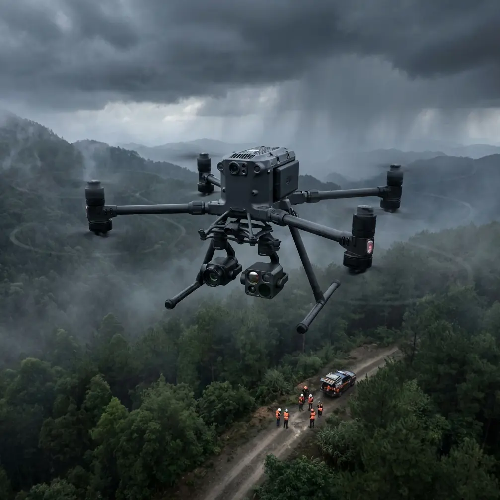
In dense, isolated woodland, the aircraft is usually the easiest part of the job. The real challenge is keeping data quality high when the environment shifts under you: light drops under cloud cover, wind starts pushing across a ridge, moisture builds over the canopy, and your carefully planned mission begins to drift away from ideal capture conditions. That is exactly where the Matrice 400 starts to make sense as a serious forestry platform rather than just a larger airframe.
If your goal is to map forests in remote areas, this aircraft is most useful when you stop thinking about it as a camera carrier and start treating it as a risk-control tool for data collection.
Start with the forest, not the drone
A remote forest mission usually has one of four outcomes in mind:
- canopy surface modeling for timber volume or habitat structure
- orthomosaic production for roads, firebreaks, and disturbance tracking
- thermal signature analysis for wildlife, smolder risk, or stressed vegetation
- repeatable survey baselines for change detection over time
Each objective changes how you should use the Matrice 400.
If you need high-quality photogrammetry, the mission lives or dies on consistency: speed, overlap, altitude, sun angle, and stable image geometry. If you need thermal work, the priorities shift toward timing, emissivity awareness, and understanding what the canopy is hiding from you. In either case, remote forest mapping punishes sloppy planning because returning for a second capture window may mean another long drive, another weather gamble, and another lost day.
That is why the pre-flight phase matters more than most operators admit.
Build the mission around transmission reliability
In remote forestry work, one problem appears before almost everything else: signal confidence. You may be launching from a logging road, a clearing, or a ridge line, but the aircraft is going to spend part of the mission crossing uneven terrain, dense vegetation, and changing line-of-sight conditions.
This is where O3 transmission has operational value beyond a spec sheet bullet. In forest mapping, strong transmission is not just about seeing the live feed. It affects your confidence in maintaining mission awareness as the aircraft works across broken topography. If weather shifts and you need to make a decision quickly, stable command-and-control becomes the difference between adjusting the mission and aborting blindly.
On one forest block, this became very real halfway through a mapping run. We launched into acceptable morning conditions: light wind, steady visibility, and enough brightness for a clean photogrammetry pass. Mid-flight, cloud cover thickened from the west and the wind began to shear over a slope edge. Nothing dramatic, but enough to alter groundspeed and change the quality of light over the canopy. The Matrice 400 held its line well, and the transmission link stayed stable enough to monitor the aircraft’s position and feed without the kind of intermittent uncertainty that tends to force premature mission termination.
That matters. A weather change does not automatically ruin a mission. What ruins it is losing situational clarity while trying to decide whether to continue, re-task, or recover.
Use hot-swap batteries as a continuity tool
Remote forest work is rarely done near power, shelter, or paved access. You may hike batteries into a launch point or operate from a vehicle several kilometers from the actual survey block. Every landing costs time, and every interruption introduces inconsistency into the dataset.
Hot-swap batteries are one of those features that sound convenient until you use them in difficult terrain. Then they become central to the workflow. In practical terms, they let you keep the aircraft powered during battery changes, which reduces downtime between sorties and helps preserve operational continuity when you are running sequential mapping blocks.
For forestry mapping, that continuity affects more than convenience:
- it helps maintain mission tempo during narrow weather windows
- it reduces the chance of long delays between adjacent capture grids
- it supports repeated launches when you need both RGB and thermal passes
- it lowers the friction of working far from charging infrastructure
Imagine trying to complete a large remote stand before afternoon convection builds. If your first block finishes and you need to shut down completely before the next launch, the lost minutes stack up. With hot-swap capability, the Matrice 400 is better positioned for back-to-back acquisition, which is especially useful when the weather starts changing but is still manageable enough to finish priority sections.
That can save the mission.
Secure the data path if the forest is sensitive
Not every forest survey is simple land management. Some operations involve protected habitats, critical infrastructure corridors, utility routes, or environmentally sensitive projects where location data and imagery are not something you want casually exposed.
AES-256 matters here. Not because operators need a cybersecurity slogan, but because forestry missions increasingly intersect with regulated or sensitive geospatial information. If your work involves concession boundaries, restoration sites, or infrastructure routes inside wooded terrain, protecting links and operational data becomes part of professional field discipline.
This is easy to overlook in routine mapping conversations. People focus on camera settings and overlap percentages. But if you are collecting imagery that reveals access roads, asset locations, burn scars, or protected zones, secure transmission is operationally significant. The Matrice 400’s AES-256 support is one of those details that becomes more valuable as the mission stakes increase.
For teams handling sensitive forestry projects, that security layer is not abstract. It is part of the chain of custody for mission information.
Plan photogrammetry like the canopy is trying to fool you
Forest photogrammetry is deceptive. From altitude, the canopy can look uniform and manageable. In processing, it often reveals all the hidden problems you failed to control: repetitive textures, shadows, motion blur from wind-driven foliage, and weak reconstruction in areas where trees lack distinct features.
To get strong results with the Matrice 400, build your mission around consistency rather than speed.
Use terrain-aware thinking even if your software automates much of the pathing. Remote forest blocks often include elevation changes that affect ground sampling distance across the site. If the aircraft maintains a simple altitude relative to takeoff point, image scale can vary more than you expect as the terrain rises or drops under the route. That inconsistency weakens your model, especially along ridges and drainage lines.
A few field rules help:
- prioritize stable overlap across the whole block rather than racing to finish
- avoid launching too late if low-angle light will exaggerate canopy shadows
- watch wind in the treetops, not just at the launch point
- use GCPs where access allows, especially on edges, roads, and clearings
- separate “good enough for viewing” from “good enough for measurement”
GCP placement in forests is never elegant. You may only have roads, skid trails, stream crossings, or small openings. Use them anyway. Even a limited set of well-measured control points can improve alignment confidence and reduce the false comfort that comes from a model that looks sharp but drifts spatially.
Thermal work needs different discipline
Thermal signature collection over forests is useful, but it is easy to misread. Canopy density can hide ground features completely. Moisture, solar loading, and mixed species composition can create temperature patterns that look meaningful and are not. This is where mission design needs more restraint than enthusiasm.
If you are using the Matrice 400 for thermal forestry work, define the question first. Are you looking for heat anomalies after a fire event? Wildlife presence near openings? Water movement under stressed vegetation? Equipment or human activity in a remote zone? Each objective changes timing and altitude decisions.
Thermal data is strongest when you understand what the canopy will mask and when the environment gives you usable contrast. Early morning or late-evening windows can help, but not universally. After weather shifts, conditions may improve for one task and worsen for another. A cloud bank that reduces harsh visual shadows may also flatten thermal contrast if surface temperatures begin to equalize.
That is another reason mid-flight judgment matters. During the same sort of weather swing that complicates RGB mapping, thermal opportunities can open or close quickly. A capable aircraft helps, but the operator still has to know when the mission objective has changed with the atmosphere.
What to do when weather shifts during the mission
This is the part many how-to articles avoid. Real flights go off-plan.
If the weather changes mid-flight while mapping remote forests with the Matrice 400, do not default to either panic or stubbornness. Work through the mission in layers:
First, assess control confidence. If O3 transmission remains stable and aircraft behavior is predictable, you still have room to make good decisions. If situational awareness is degrading, bring the aircraft home before the data problem becomes a safety problem.
Second, assess whether the weather change affects geometry or only aesthetics. Cloud cover, for example, is not always bad for photogrammetry. In some cases it softens contrast and reduces harsh shadowing. Wind is more dangerous than cloud when foliage movement starts to undermine image consistency.
Third, re-rank your priorities. If the full block is no longer realistic, finish the most valuable section first. Use the Matrice 400’s efficient battery workflow to land, hot-swap, and relaunch quickly if a narrower weather gap opens.
Fourth, document the change. Note wind behavior, light conditions, and the exact segment of the survey affected. This becomes critical during processing when you are diagnosing weaker tie points or inconsistent thermal behavior.
If you need a second set of eyes on flight planning for remote woodland jobs, this quick field coordination channel is a practical option.
BVLOS changes the scale of what is possible, but not the need for discipline
For remote forestry, BVLOS is often the elephant in the room. Large, inaccessible tracts are exactly the type of environment where beyond visual line of sight operations can transform productivity. The Matrice 400 is the kind of platform operators naturally discuss in that context because remote mapping is where endurance, transmission reliability, and mission continuity start to pay off.
But BVLOS is not a shortcut. It raises the standard for planning, communications, detect-and-avoid procedures, operational approvals, and route design. In practical forestry operations, the temptation is to think of BVLOS as simply extending the same visual-line workflow over a larger area. That mindset creates trouble.
The better approach is to redesign the mission from the ground up:
- segment the survey according to risk, terrain, and emergency options
- define communication loss procedures before launch
- consider how canopy and topography affect not just imagery but command margins
- plan battery cycles and recovery points conservatively
- secure operational data if the mission area is sensitive
When done properly, BVLOS can make remote forest mapping dramatically more efficient. When done casually, it magnifies every small planning error.
A practical workflow for forest mapping with the Matrice 400
For operators who want a repeatable method, this is the sequence I would use.
Start by classifying the forest block: canopy density, terrain variation, access points, likely wind behavior, and whether the deliverable is orthomosaic, 3D model, thermal survey, or repeat monitoring. Then choose launch and recovery points that give you the cleanest command environment, not merely the shortest walk.
Next, establish control strategy. If GCP deployment is limited, identify the few places where they will provide the most leverage: clearings, road intersections, exposed ground, and edge features.
Then build the mission around data integrity. Set overlap generously enough for canopy complexity. Keep speed conservative if treetop movement is likely. Time the flight for light conditions that support your actual output rather than whatever is most convenient for travel.
Once airborne, treat the live mission as dynamic. Watch canopy motion, not just telemetry. Monitor whether changing light is helping or hurting your capture objective. If conditions shift, use the aircraft’s stable transmission link and battery continuity to adapt intelligently instead of trying to force the original plan.
Finally, process with skepticism. Forest datasets often look acceptable before they prove accurate. Check reconstruction quality in shadowed areas, along slope breaks, and near edges where GCP influence is weakest.
Why the Matrice 400 fits this job
The strongest case for the Matrice 400 in remote forest mapping is not that it does everything. It is that it addresses several of the failure points that usually degrade hard field missions.
O3 transmission improves decision quality when terrain and distance begin to erode operator confidence. Hot-swap batteries preserve tempo when the window is narrow and the forest is far from support. AES-256 supports secure operations when the mapped area includes sensitive environmental or infrastructure information. Add thermal signature capability, photogrammetry potential, and a platform that can be worked into serious BVLOS planning, and you get a tool that is well matched to remote forest realities rather than brochure scenarios.
That is the real story.
Forest mapping is not won by flying once over a patch of trees. It is won by collecting defensible data under imperfect conditions, adapting when the weather turns, and bringing home a dataset that still stands up in processing. The Matrice 400 earns its place when the mission gets messy and the operator needs options, not optimism.
Ready for your own Matrice 400? Contact our team for expert consultation.