Matrice 400 for Forest Mapping in Complex Terrain: A Field
Matrice 400 for Forest Mapping in Complex Terrain: A Field-Ready Workflow That Starts Before Takeoff
META: Learn how to use the Matrice 400 for forest mapping in steep, obstructed terrain with a practical pre-flight workflow covering cleaning, photogrammetry, thermal data, transmission, battery strategy, and mission safety.
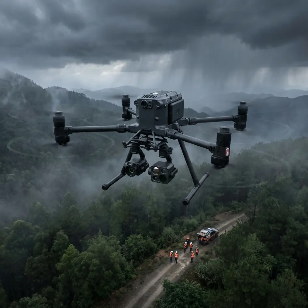
Forest mapping gets difficult the moment the terrain stops behaving. Ridge lines break line of sight. Dense canopy interferes with visual checks. Moisture, dust, pollen, and fine debris collect where they matter most: lenses, vents, sensors, and connectors. In that environment, the Matrice 400 is not just a bigger aircraft with longer endurance. It becomes a systems platform, and the quality of your map depends on how carefully you treat that system before the props even start.
I approach this as a field operator first and a data person second. If you are mapping forests in complex terrain, your mission quality is usually lost in one of three places: poor pre-flight preparation, weak control of image consistency, or avoidable interruptions once you are already deep into the job. The Matrice 400 can reduce all three, but only if you build your workflow around its actual strengths rather than its headline reputation.
This guide is written for crews planning forest mapping missions where slopes, variable canopy height, narrow launch areas, and intermittent signal paths are normal conditions.
Start with cleaning, not calibration
Most teams talk about mission planning first. In mountain forest work, I start with cleaning. That is not housekeeping. It is a safety and data-quality step.
Before powering the Matrice 400, inspect and clean the forward vision sensors, downward sensing surfaces, payload lenses, landing gear joints, battery contacts, and air intake or cooling areas. In wooded environments, I often see a thin film of dust mixed with tree resin or pollen. It may be almost invisible in flat light, yet it can degrade obstacle sensing performance, reduce image clarity, and trap heat.
This matters operationally for two reasons.
First, if your obstacle sensing or positioning inputs are compromised by grime, your aircraft may become less predictable near uneven terrain, tree edges, or confined launch points. That is exactly where you need confidence in the aircraft’s safety stack.
Second, a photogrammetry mission can be ruined by something as simple as a smudged lens. One contaminated lens can soften a whole segment of nadir or oblique captures, reducing tie-point reliability and forcing rework. If you are collecting thermal signature data alongside visible imagery, contamination is even more costly because thermal interpretation depends on clean, stable sensor input. A dirty optical surface can distort contrast and undermine hotspot differentiation in canopy or understory analysis.
My field sequence is simple: dry air blower first, soft lens-safe brush second, approved wipe last only if needed. Never start with pressure and friction if grit is still on the surface. That is how crews create scratches that stay with the payload for the season.
Build the mission around terrain, not just acreage
Forest mapping in complex terrain is rarely about covering the maximum area per flight. The real task is to preserve overlap, positional consistency, and link stability while the landscape keeps changing under the aircraft.
With the Matrice 400, the planning advantage comes from platform endurance and mission continuity. Longer flight windows let you divide a difficult forest block according to terrain logic rather than battery anxiety. That changes the quality of the final output. Instead of forcing one broad grid across ridges and ravines, you can split the mission into terrain-matched sections with adjusted altitude references, overlap targets, and emergency return assumptions.
In practical terms, I recommend breaking the site into at least three mission layers:
- Primary photogrammetry grid for orthomosaic and surface model generation
- Targeted oblique collection for steep cut slopes, ravines, and canopy-edge geometry
- Thermal pass, if required, timed around the actual survey objective rather than bundled carelessly with the visible mission
Each layer answers a different problem. The visible grid is your baseline map. Obliques help where vertical relief would otherwise create gaps or poor reconstruction. The thermal layer supports analysis of drainage patterns, stressed vegetation pockets, post-disturbance assessment, or search-related signatures, depending on the mission.
The Matrice 400 is especially valuable when these layers need to be executed in the same operational window without constant downtime.
Why transmission quality changes forest outcomes
Open ground forgives mediocre link planning. Forest terrain does not.
This is where O3 transmission becomes more than a specification line. In steep, obstructed environments, transmission stability affects your ability to maintain command confidence as the aircraft transitions behind ridge features, along drainage corridors, or near dense canopy margins. If your control and video link is fragile, your mission planning becomes timid. You shorten lines, widen buffers, and accept less efficient coverage simply to stay comfortable.
A stronger transmission architecture allows more disciplined route design. That does not mean carelessness, and it certainly does not mean you can ignore terrain masking. It means the aircraft is better suited to a real mapping envelope where brief signal challenges are part of the environment rather than an abnormal event.
For forestry teams considering extended route operations or future BVLOS workflows, transmission resilience also influences documentation and risk planning. Even where BVLOS authority depends on local regulation, terrain analysis, observer placement, and operational approval, the aircraft’s communication capability remains central to whether the mission design is credible in the first place.
I advise crews to walk the launch point and identify two things before finalizing their route: probable line-of-sight interruptions and the safest arc for manual recovery if terrain or canopy causes an unexpected change. The aircraft’s capability helps, but your route geometry still has to respect the landscape.
AES-256 is not just an IT talking point
Forest mapping projects are increasingly tied to infrastructure, environmental compliance, utility corridors, watershed studies, and land management records. That means the data is often more sensitive than operators assume.
AES-256 matters because security begins during acquisition, not after the files are already copied to a workstation. If your mission involves protected land, strategic assets, or proprietary environmental assessments, secure transmission and data handling are part of operational professionalism, not administrative paperwork.
This has a direct field implication. When teams know their platform supports strong data protection practices, they are more willing to integrate drone-derived mapping into workflows that previously stayed limited to manned survey or fragmented ground collection. For the Matrice 400, that widens its role from image capture platform to trusted node in a larger geospatial pipeline.
For mixed public-private forestry projects, that trust can affect whether stakeholders accept drone-derived outputs for planning and reporting.
Hot-swap batteries change how you schedule the site
Complex terrain wastes time in small, expensive increments. Hiking back to a launch position, re-establishing the controller setup, rechecking payload readiness, then waiting through a cold restart all compound into coverage gaps and rushed decisions.
Hot-swap batteries are one of the most operationally meaningful features in this class because they reduce the break between flights. That helps in two ways.
First, you preserve mission tempo. The crew can land, change power, confirm aircraft status, and relaunch without turning every battery transition into a partial reset of the operation. On remote forest sites, that keeps the team mentally inside the mission instead of repeatedly rebuilding focus.
Second, you preserve environmental consistency. Light angle, wind behavior in valleys, and thermal contrast can shift quickly in forests. A faster turnaround reduces the mismatch between one flight block and the next. That improves stitching consistency for photogrammetry and makes thermal interpretation less vulnerable to changing ambient conditions.
This is particularly useful when you are mapping long, irregular corridors through wooded terrain or need to finish a grid before a weather window closes.
Use GCPs strategically, not excessively
Ground control points still matter, especially in forests where canopy, slope, and limited open sky can degrade assumptions about absolute accuracy. But crews often misuse them by placing too many in easy locations and too few where terrain actually stresses the model.
On a Matrice 400 forest mission, I prefer fewer, better-positioned GCPs. Place them where they strengthen the geometry of the survey:
- At elevation extremes
- Near terrain breaks
- At the edges of the mission block
- In limited canopy openings where visibility from the planned flight altitude is reliable
- Near critical features that downstream users will actually measure
The point is not to scatter targets for comfort. The point is to anchor the model where distortion is most likely.
If the site is dense enough that GCP visibility is poor, supplement with carefully planned check points and make sure your flight design supports strong image overlap over the sparse open areas you do have. The aircraft can stay in the air longer, but that only helps if your control strategy is deliberate.
Photogrammetry in forests needs disciplined capture settings
A common mistake in wooded terrain is flying too low out of caution and too fast out of schedule pressure. That combination can hurt the model.
The Matrice 400 gives you room to be more methodical. Use that advantage. Your image capture plan should account for canopy texture, shadow variation, and vertical relief. In many forest environments, homogeneous treetops do not reconstruct as cleanly as operators expect, especially when lighting is harsh or wind causes subtle movement across the canopy.
The remedy is not guesswork. It is controlled overlap, appropriate altitude relative to terrain, and oblique support where needed. If your mission objective includes road cuts, drainage channels, firebreaks, or unstable slopes under partial canopy, obliques are not optional extras. They are what keep the model usable at the edges where management decisions are often made.
I also recommend checking sample imagery in the field after the first short segment, not after the whole first battery set. Look for motion softness, exposure inconsistency, and areas where shadows crush detail. That five-minute review is worth more than a perfect-looking mission plan on a tablet.
Thermal signature work demands timing discipline
Thermal data can add real value in forestry, but only if the mission is tied to a defined question. Are you looking for water movement patterns below canopy gaps, stressed vegetation zones, residual heat after a fire event, or search-related detection? The answer determines your timing.
The Matrice 400 platform is well suited to paired visible and thermal workflows because it supports a more continuous, less interrupted field operation. But do not assume thermal should be flown whenever the visible mission is flown. In many cases, the best thermal window is earlier, later, or under different atmospheric conditions than the best photogrammetry window.
The operational significance is straightforward: one aircraft can support both mission types efficiently, but the pilot and mapping lead should still separate the objectives. If you blend them carelessly, both datasets become average.
A practical field sequence for complex terrain
If I were briefing a forest crew using the Matrice 400 tomorrow, the workflow would look like this:
- Clean all sensing and imaging surfaces before power-up
- Inspect props, battery interfaces, payload mount security, and cooling paths
- Confirm mission segmentation by terrain zone, not by arbitrary equal area
- Verify GCP and checkpoint visibility against real canopy conditions
- Run a short test leg and review image sharpness before committing
- Keep battery changes fast and organized to preserve mission continuity
- Reassess link quality at each terrain transition instead of assuming uniform coverage
- Separate thermal collection from visible mapping when the survey goal requires different timing
That sequence sounds conservative. It is actually what lets you move faster overall, because it cuts out preventable failure.
If your team is refining its own forest mapping procedures around this platform, it helps to compare notes with operators who work in similar terrain; I often suggest teams start that conversation through this quick field contact channel: https://wa.me/example
Where the Matrice 400 fits best
The Matrice 400 is not valuable simply because it is capable. It is valuable because its capabilities line up unusually well with the friction points of forest mapping: interrupted terrain, long walking distances, inconsistent line of sight, narrow weather windows, and the need to gather more than one kind of dataset on the same deployment.
O3 transmission supports better route confidence in obstructed environments. AES-256 supports secure handling of sensitive survey operations. Hot-swap batteries reduce downtime that would otherwise fragment the mission. And when you pair those strengths with disciplined pre-flight cleaning, thoughtful GCP placement, and a survey design built around terrain rather than convenience, the aircraft becomes more than a platform for image capture. It becomes a reliable field instrument.
That distinction matters in forestry. Anyone can collect pictures over trees. The hard part is returning with a dataset that holds up when planners, engineers, ecologists, or emergency teams start making decisions from it.
For complex terrain, that result starts with the first wipe of the sensor glass, not the first waypoint on the screen.
Ready for your own Matrice 400? Contact our team for expert consultation.