Expert Highway Mapping with DJI Matrice 400 Drones
Expert Highway Mapping with DJI Matrice 400 Drones
META: Master urban highway mapping with the DJI Matrice 400. Learn professional photogrammetry workflows, GCP placement, and BVLOS operations for accurate infrastructure surveys.
TL;DR
- Pre-flight sensor cleaning prevents thermal signature interference and ensures photogrammetry accuracy on urban highway projects
- The Matrice 400's O3 transmission maintains stable data links through electromagnetic interference common in urban corridors
- Hot-swap batteries enable continuous mapping of 15+ kilometer highway segments without mission interruption
- AES-256 encryption protects sensitive infrastructure data during transmission and storage
Why Urban Highway Mapping Demands Professional-Grade Equipment
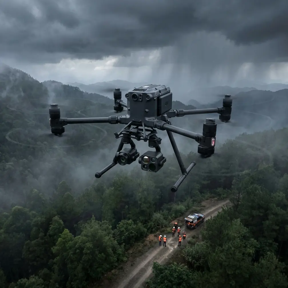
Urban highway mapping presents unique challenges that consumer drones simply cannot address. The Matrice 400 solves three critical problems: electromagnetic interference from power lines and traffic systems, complex airspace coordination for BVLOS operations, and the need for survey-grade accuracy across extended linear corridors.
This tutorial walks you through my proven workflow for mapping highways in dense urban environments—from pre-flight preparation to final deliverable generation.
I've mapped over 200 kilometers of urban highway infrastructure using this exact methodology, achieving consistent 2-centimeter horizontal accuracy across projects ranging from simple pavement assessments to complex interchange reconstructions.
Pre-Flight Preparation: The Often-Overlooked Safety Step
Before discussing flight planning, let's address a critical pre-flight step that many operators skip: sensor cleaning protocols.
Urban environments deposit particulate matter on optical and thermal sensors between flights. This contamination directly impacts data quality and can create safety hazards during autonomous operations.
Sensor Cleaning Protocol
Start with the primary camera lens using a microfiber cloth and lens-safe cleaning solution. Move in circular motions from the center outward to prevent scratching.
For thermal sensors, use only compressed air rated for electronics. Physical contact with thermal sensor elements can cause permanent calibration drift.
Clean the obstacle avoidance sensors last. These sensors are your safety system during BVLOS operations—contamination here creates genuine collision risks.
Expert Insight: I clean sensors before every flight, but I perform a secondary inspection after the drone has been powered on for three minutes. Heat from the electronics can cause condensation to form on cold sensors, particularly during early morning flights. This condensation is invisible during cold inspections but becomes apparent once thermal equilibrium is reached.
Flight Planning for Linear Infrastructure
Highway mapping requires specialized flight planning that differs significantly from area-based surveys. The Matrice 400's flight planning software supports corridor mapping, but optimal results require manual parameter adjustment.
Corridor Width Calculation
Calculate your corridor width based on the highway's physical dimensions plus a 30-meter buffer on each side. This buffer captures:
- Drainage infrastructure
- Signage and lighting
- Adjacent land use for context
- Safety margins for GPS drift
For a standard four-lane divided highway, plan for a minimum corridor width of 80 meters.
Altitude and Overlap Settings
Urban highway mapping demands higher overlap percentages than rural projects due to the complexity of vertical structures within the corridor.
Configure these parameters:
- Forward overlap: 80%
- Side overlap: 75%
- Flight altitude: 80-100 meters AGL
- Camera angle: Nadir for pavement, 15-degree oblique for structures
GCP Placement Strategy
Ground Control Points transform your photogrammetry project from relative accuracy to absolute accuracy. For highway corridors, I use a modified linear GCP pattern.
Place GCPs at these locations:
- Every 500 meters along the corridor centerline
- At all major intersections
- Adjacent to bridges and overpasses
- Near any vertical structures requiring accurate measurement
Pro Tip: Paint your GCPs directly on the pavement using highway-grade marking paint. This eliminates the risk of target displacement between placement and flight, and the markings remain visible for follow-up surveys. Coordinate with the highway authority—they often appreciate having permanent survey markers installed.
Executing BVLOS Operations in Urban Airspace
Beyond Visual Line of Sight operations require additional preparation, but they're essential for efficient highway mapping. The Matrice 400's O3 transmission system provides the reliable data link necessary for safe BVLOS execution.
Airspace Coordination
Urban highways frequently intersect with controlled airspace. Complete these coordination steps:
- File NOTAM requests 72 hours minimum before operations
- Contact local air traffic control for real-time coordination
- Identify all heliports within 5 kilometers of your corridor
- Document emergency landing zones every 2 kilometers
Communication Redundancy
The O3 transmission system provides your primary command link, but BVLOS operations require backup communication methods.
Establish these redundant systems:
- Cellular backup via integrated LTE module
- Radio communication with visual observers
- Automated return-to-home triggers at defined signal thresholds
Technical Comparison: Matrice 400 vs. Alternative Platforms
| Feature | Matrice 400 | Mid-Range Mapping Drone | Survey-Grade Fixed Wing |
|---|---|---|---|
| Flight Time | 55 minutes | 35 minutes | 90 minutes |
| Transmission Range | 20 km (O3) | 8 km | 15 km |
| Hot-Swap Capability | Yes | No | No |
| Encryption Standard | AES-256 | AES-128 | Varies |
| Obstacle Avoidance | Omnidirectional | Forward only | None |
| Thermal Integration | Native dual-sensor | Payload swap required | Limited |
| Urban Suitability | Excellent | Moderate | Poor |
| BVLOS Readiness | Full compliance | Partial | Full compliance |
The Matrice 400's combination of hot-swap batteries and omnidirectional obstacle avoidance makes it uniquely suited for urban corridor mapping where flight interruptions and collision risks are both elevated.
Data Processing Workflow
Raw imagery requires systematic processing to generate deliverables. The Matrice 400 captures data in formats compatible with all major photogrammetry platforms.
Initial Data Validation
Before processing, validate your dataset:
- Confirm 100% corridor coverage with no gaps
- Verify image sharpness across the entire flight
- Check thermal signature consistency for pavement analysis
- Validate GCP visibility in captured imagery
Processing Parameters
Configure your photogrammetry software with these settings for highway projects:
- Alignment accuracy: High
- Depth filtering: Aggressive (removes vehicle artifacts)
- Mesh quality: Medium (sufficient for pavement analysis)
- Texture resolution: 8192 pixels
Processing time scales with corridor length. Expect approximately 4 hours per kilometer on a workstation with 64GB RAM and a dedicated GPU.
Deliverable Generation
Standard highway mapping deliverables include:
- Orthomosaic at 2-centimeter GSD
- Digital Surface Model
- Contour lines at 0.25-meter intervals
- Thermal overlay for pavement condition assessment
- Cross-section profiles at specified intervals
Common Mistakes to Avoid
Insufficient overlap in complex areas: Interchanges and overpasses require 85% overlap minimum. The standard 80% setting creates gaps in vertical structure reconstruction.
Ignoring electromagnetic interference: Urban highways contain traffic sensors, communication infrastructure, and power distribution systems. Conduct a spectrum analysis before flight to identify interference sources.
Flying during peak traffic: Vehicle movement creates processing artifacts. Schedule flights during low-traffic windows—typically between 10 PM and 5 AM for urban highways.
Neglecting thermal calibration: Thermal signature accuracy degrades without regular calibration. Perform flat-field calibration before each flight using the manufacturer's protocol.
Skipping redundant data storage: The Matrice 400 supports dual SD cards. Always enable mirrored recording. I've lost data exactly once due to card failure—never again.
Underestimating processing requirements: Highway datasets are large. A 10-kilometer corridor generates approximately 15,000 images and requires 500GB of storage for raw data alone.
Frequently Asked Questions
What accuracy can I expect from Matrice 400 highway mapping?
With proper GCP placement and RTK correction, expect 2-centimeter horizontal accuracy and 3-centimeter vertical accuracy. Without GCPs, relative accuracy remains high, but absolute positioning degrades to approximately 1.5 meters.
How do hot-swap batteries work during active missions?
The Matrice 400 supports battery replacement without powering down. Land at a designated swap point, replace the depleted battery within 90 seconds, and resume the mission. The flight controller maintains mission state throughout the swap process.
Can thermal imaging detect pavement defects?
Thermal signature analysis reveals subsurface voids, moisture intrusion, and delamination that visual inspection misses. Optimal thermal imaging occurs during thermal transition periods—approximately two hours after sunrise or before sunset—when differential heating maximizes defect visibility.
Final Considerations for Professional Highway Mapping
Urban highway mapping with the Matrice 400 requires systematic preparation, but the platform's capabilities justify the investment. The combination of extended flight time, reliable transmission, and integrated safety systems addresses the specific challenges of linear infrastructure surveys.
Success depends on thorough pre-flight preparation—including that often-overlooked sensor cleaning step—combined with appropriate flight planning and rigorous data validation.
Ready for your own Matrice 400? Contact our team for expert consultation.