Matrice 400 in Thin Air: A Highway Mapping Case Study
Matrice 400 in Thin Air: A Highway Mapping Case Study from High Altitude
META: A field-based Matrice 400 case study on high-altitude highway mapping, covering photogrammetry, thermal workflows, GCP strategy, O3 transmission, AES-256 security, hot-swap batteries, and BVLOS planning.
By Dr. Lisa Wang, Specialist
High-altitude corridor mapping looks straightforward on a whiteboard. In the field, it rarely is.
A highway project in mountainous terrain forces every weak assumption into the open. Air is thinner. Weather turns faster. Batteries feel smaller. Radio links behave differently than they did at lower elevations. Ground control placement takes longer because every marker may require a climb, a road closure window, or a compromise with terrain. And if the assignment is a long linear asset rather than a compact site, efficiency stops being a nice metric and becomes the thing that determines whether the job gets finished on schedule.
That is where the Matrice 400 becomes interesting.
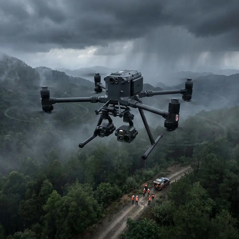
This is not about a drone being “powerful” in some vague marketing sense. It is about how a platform behaves when the task is highway photogrammetry in high altitude conditions, where the output must support design, maintenance planning, slope observation, and corridor documentation without introducing avoidable field risk. In this case study, the real story is not one single specification. It is the way several system-level features work together: stable transmission through O3, protected data links with AES-256, battery continuity through hot-swap operations, and the flexibility to combine visible and thermal perspectives when terrain or roadside conditions demand more than a standard orthomosaic.
The assignment: map a mountain highway, not just a parcel
The project scenario was a long highway section crossing elevated terrain with sharp grade changes, exposed shoulders, scattered rockfall zones, and intermittent wildlife activity near the roadside. The deliverables were typical on paper: photogrammetric outputs for corridor mapping, surface reconstruction, and condition review. In practice, the mission required more than straight grid flights.
Linear infrastructure at altitude creates three overlapping problems.
First, topography compresses your margin for error. A route that appears open from one launch point can contain abrupt elevation shifts that change line-of-sight and force revised flight geometry. Second, mountain weather can interrupt a day’s work in short bursts rather than with one clean cancellation decision. Third, logistics dominate the schedule. If every battery change requires a full shutdown sequence and a lengthy reconfiguration, the productivity loss compounds across a corridor.
The Matrice 400 matters here because it fits a field workflow, not just a brochure category.
Why O3 transmission changes the mapping conversation
For corridor work, transmission quality is not a side detail. It influences flight confidence, route planning, payload monitoring, and decision-making in real time. The Matrice 400’s use of O3 transmission is operationally meaningful because long, narrow projects rarely give you ideal geometry between aircraft and operator. On a highway flanked by ridges, the challenge is not merely distance. It is maintaining reliable awareness while terrain repeatedly tries to interrupt signal behavior.
A robust transmission system gives the pilot and mission team cleaner live situational feedback when the aircraft is moving along uneven ground profiles. That matters for more than safety. It affects image collection discipline. If the crew can reliably monitor the aircraft state and payload feed, they are better positioned to catch drift in mission execution before it turns into a data gap. On a photogrammetry job, a small inconsistency in overlap or a section flown under worsening visibility can lead to expensive rework.
The corridor team in this scenario used O3 as a confidence layer rather than as an excuse to push careless distance. That distinction matters. In high-altitude mapping, disciplined operations always beat headline claims. A strong transmission backbone supports conservative planning, staged progress, and cleaner handoffs across segments of a highway alignment.
AES-256 is not a footnote when infrastructure data is involved
Highway mapping often includes sensitive geospatial information: terrain models, asset condition imagery, and inspection records tied to public infrastructure. The mention of AES-256 is not there to fill a technical paragraph. It has direct value when survey data passes through field workflows that may involve multiple operators, temporary mobile setups, and remote review.
For civilian infrastructure teams, secure transmission and handling help protect project confidentiality and reduce exposure during collection. When a corridor survey includes bridges, retaining structures, culverts, slope stabilization areas, or staging zones, the data itself becomes part of the project risk profile. AES-256 matters because it supports a more defensible workflow from aircraft to controller to downstream handling.
In plain terms, if you are collecting highway data that may influence engineering decisions, maintenance planning, or contractor coordination, security should not be treated as optional polish.
Hot-swap batteries solve a real field bottleneck
Battery management is often discussed as endurance, but endurance is only half the story. In mountain corridor work, continuity matters just as much. The Matrice 400’s hot-swap battery capability is valuable because it reduces interruption between flights. That is not just a convenience feature. It changes how teams schedule segments, preserve mission rhythm, and respond to narrow weather windows.
On this project, the team was working in conditions where cloud movement and valley wind patterns created short periods of excellent mapping light followed by reduced confidence. A platform that allows hot-swap battery replacement lets the crew keep the aircraft and operation moving with less downtime between sorties. Over the course of a full day, those minutes accumulate into meaningful coverage.
There is another benefit. Frequent full restart cycles can break concentration and create more opportunities for small procedural mistakes. Hot-swap workflows support smoother transitions, better crew coordination, and more consistent execution across repeated corridor legs.
For long highway mapping at elevation, this is not a glamorous feature. It is one of the reasons the operation remains productive.
Photogrammetry at altitude requires better GCP thinking
A lot of drone mapping advice assumes that ground control points can be distributed conveniently across an area. Highway projects do not cooperate. GCP planning for a mountain corridor is less about textbook spacing and more about strategic placement where terrain, access, and safety permit reliable control.
The Matrice 400 does not remove the need for disciplined GCP work. What it does do is make it easier to collect consistent imagery over difficult sections so that control and check points can do their job effectively in processing. For this project, the GCP strategy focused on transition areas: grade changes, curves, elevation breaks, and sections where retaining structures altered the visual geometry of the roadside. Those are the places where weak control planning can show up later as subtle surface distortion or alignment inconsistency.
Operationally, this matters because highway stakeholders rarely want only a pretty map. They need outputs they can trust for measurements, comparisons, and documentation. High-altitude photogrammetry succeeds when aircraft performance, overlap discipline, and control design are treated as one system rather than three separate tasks.
Thermal signature work was not the primary deliverable, but it paid off
The initial mission centered on photogrammetry. The surprise value came from thermal signature review during selected passes near embankments and drainage features.
Thermal data in a highway environment can add context that RGB imagery misses, especially in early or late operating windows when material temperature differences are more pronounced. On this route, thermal observations helped the team distinguish between bare rock, vegetated moisture-retaining areas, and certain drainage-adjacent features that looked visually similar from the air. Thermal is not a replacement for engineering judgment, of course. But it can improve prioritization and point the ground team toward areas worth a closer look.
The practical lesson is simple: on a corridor in complex terrain, a mapping drone that can support more than one sensing objective gives the client a richer dataset from the same field deployment.
That flexibility became unexpectedly useful during one memorable moment.
The wildlife encounter that changed the flight plan
Midway through a morning segment, the payload feed showed heat movement near a cut slope above the highway shoulder. At first glance it looked like a false reading from sun-warmed rock. The thermal signature was too organized for that. A closer review revealed a small mountain goat moving along the slope edge, partly concealed by brush and rock shadow.
This mattered immediately.
The team paused the planned pass and adjusted the route to avoid unnecessary disturbance. The visible feed alone might not have picked up the animal quickly against the broken terrain. The thermal signature made the presence obvious enough to support a prompt decision. That is a good example of sensor value that rarely appears in specification tables. The point was not wildlife tracking. The point was operational awareness in a live environment where flight planning intersects with real terrain and real ecosystems.
For civil operators, this is one of the more persuasive reasons to think beyond standard RGB collection. Better sensing can support safer, more considerate mission decisions.
BVLOS planning starts on paper, not in the air
BVLOS is often discussed with too much drama and too little discipline. For highway mapping, it is best understood as a planning framework that may expand corridor efficiency when local regulations, approvals, crew procedures, and risk controls all align. The Matrice 400 is relevant to that conversation because a highway is exactly the kind of asset where beyond visual line of sight concepts can improve operational logic, especially across long, repetitive segments.
But the value is not “flying farther” for its own sake.
The real benefit is that BVLOS-ready thinking encourages stronger route segmentation, contingency design, communication procedures, and command discipline. Even when a specific mission remains within visual line of sight, a platform built with serious transmission capability, secure communications, and professional battery workflow supports the kind of methodical operation that corridor work demands.
For teams planning high-altitude mapping programs, that is the right mindset: use the aircraft’s capabilities to improve structure and predictability, not to cut corners.
What the Matrice 400 actually solved on this job
After processing and review, the value of the platform came down to four practical wins.
One, it supported reliable corridor progression in uneven mountainous terrain where transmission consistency could not be taken for granted. O3 was important because it underpinned aircraft awareness and payload confidence, not because it enabled reckless distance.
Two, the hot-swap battery workflow reduced dead time and helped the crew capitalize on short favorable weather windows. In mountain work, a narrow opening in conditions can decide whether an extra segment gets completed that day.
Three, AES-256 gave the project team a stronger security posture around infrastructure mapping data. That matters more than many operators admit.
Four, the ability to integrate thermal signature review alongside photogrammetry improved situational awareness and yielded added insight around roadside conditions and live environmental factors, including the mountain goat encounter that prompted an immediate route adjustment.
None of those points is flashy by itself. Together, they describe a platform that fits the reality of high-altitude infrastructure operations.
Field advice for teams planning similar missions
If you are preparing to map highways at elevation with a Matrice 400, focus less on maximum claims and more on mission architecture.
Build your GCP plan around terrain transitions, not just equal spacing. Treat transmission as a decision-support tool, not a dare. Use hot-swap battery procedures to protect tempo during short weather windows. Bring thermal into the workflow selectively, where it can add context rather than noise. And if your project may move toward BVLOS-type operating structures, begin with documentation quality, crew discipline, and communication planning long before the aircraft lifts off.
A mature operation is usually quiet. Few surprises, clean handoffs, repeatable outputs.
That was the lesson from this mountain highway job. The Matrice 400 did not simplify the terrain. It did something more useful: it made the terrain manageable.
If your team is working through a similar corridor mapping challenge and wants to compare workflows, payload strategy, or high-altitude planning assumptions, you can start the conversation here via direct field coordination on WhatsApp.
Ready for your own Matrice 400? Contact our team for expert consultation.