Mapping Highways in Complex Terrain With Matrice 400
Mapping Highways in Complex Terrain With Matrice 400: Practical Field Tactics That Actually Hold Up
META: Expert field guide to using Matrice 400 for highway mapping in difficult terrain, with practical advice on EMI handling, photogrammetry workflow, thermal use, battery planning, and structural reliability thinking.
Highway mapping sounds straightforward until the road stops behaving like a line on a plan set.
The moment a corridor cuts through rock faces, bends around wet valleys, climbs into wind-sheared ridges, or passes under transmission infrastructure, the mission stops being about simple coverage. It becomes a discipline of control, repeatability, and risk management. That is exactly where a Matrice 400 workflow needs to be judged: not by brochure-level capability, but by whether it can keep survey-grade logic intact when the environment starts adding noise.
For teams mapping highways in complex terrain, the real challenge is not just collecting enough imagery. It is preserving data quality while the aircraft deals with electromagnetic interference, variable signal geometry, changing relief, and long corridor legs that punish weak flight planning. The Matrice 400 sits in that intersection of airframe endurance, transmission stability, payload flexibility, and operational discipline. Used correctly, it can turn a difficult corridor job into a predictable one. Used casually, it can create beautiful-looking but unreliable outputs.
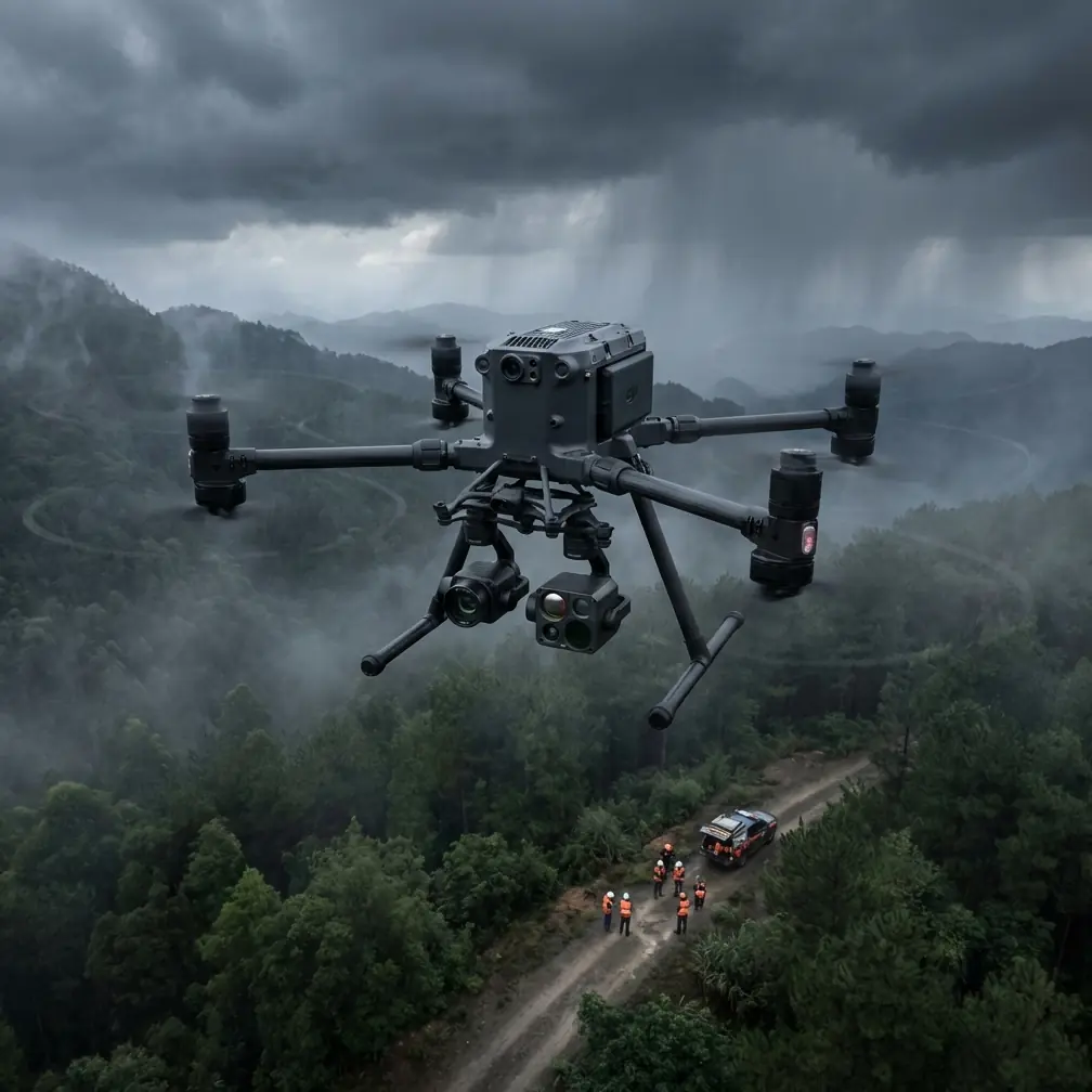
The actual problem: corridor mapping is unforgiving
A highway project is a narrow target spread over a very long distance. That sounds efficient for drones. In practice, it creates several technical traps.
First, terrain changes break consistency. A straight section through open ground can be flown with tidy overlap and stable altitude above ground. Minutes later, the same route may run alongside a cut slope, over a bridge approach, or through a section with sharp elevation variation. If your photogrammetry settings and flight profile do not adapt, you get uneven ground sampling distance, poor tie points, and reconstruction gaps in the exact places engineers care about most.
Second, corridor missions often encounter interference sources. High-voltage lines, telecom structures, roadside installations, and even some industrial assets near the route can affect link quality and operational confidence. This is where pilots who understand antenna geometry outperform pilots who simply trust auto settings.
Third, long jobs expose weaknesses in energy planning. If the aircraft supports hot-swap batteries, that matters less as a convenience feature and more as a way to preserve mission tempo and positional consistency across repeated sorties. On a highway project, every unnecessary reset costs time and increases the chance of drift in field execution.
Fourth, modern clients are not asking for one output. They want orthomosaics, terrain models, cut-and-fill context, thermal signature checks in selected sections, and sometimes progress documentation suitable for remote stakeholders. One platform often has to support several layers of capture logic.
That is why the Matrice 400 discussion should not start with generic performance claims. It should start with workflow integrity.
Why transmission stability matters more here than on most drone jobs
On a corridor mission, transmission is not merely about keeping video visible. It is about maintaining command confidence over elongated flight paths where terrain and roadside infrastructure continuously change the radio environment.
The operational value of an advanced link such as O3 transmission becomes obvious when the aircraft is moving in and out of partial terrain masking or reflective EMI-heavy zones. The pilot is not just watching for image feed quality. They are judging whether the aircraft is still behaving predictably enough to preserve the mapping run without introducing yaw corrections, hesitation, or manual disruptions that weaken overlap consistency.
In the field, one of the most effective habits is simple: adjust antenna orientation before the problem becomes visible on screen. If the highway bends and the aircraft transitions from broadside to a more oblique angle relative to the pilot position, the signal geometry changes. In interference-prone sections, that can be enough to degrade confidence. Small antenna corrections, made early, often stabilize the link before packet loss or control hesitation appears.
I have seen crews misdiagnose this. They blame the terrain, or the aircraft, when the issue is really pilot-side orientation discipline. The fix is not dramatic. Keep the controller aimed with intention. Reposition if needed. Do not stand in the worst possible place simply because it is convenient to park there.
This matters even more when teams are planning for BVLOS-type corridor logic within the boundaries of local regulation and approved procedures. Even when a mission is not formally flown as BVLOS, the route design often borrows from BVLOS thinking: long linear progression, planned handoff points, communication discipline, and reduced tolerance for improvised corrections. In that style of operation, transmission quality is a mission variable, not a comfort feature.
Photogrammetry quality begins before takeoff
Many corridor teams still think photogrammetry problems are solved in processing. They are not. They are prevented in planning.
For highway mapping in mixed relief, the Matrice 400 should be treated as a data collection platform first and a flying camera second. That means every parameter has to support reconstruction, not just flight completion.
Start with terrain-aware altitude logic whenever possible. A fixed-height mission over rolling ground may complete successfully while still delivering inconsistent pixel scale. That is acceptable for visual reference. It is not acceptable if the output will inform grading, drainage interpretation, slope assessment, or progress validation.
Ground control points remain non-negotiable if the deliverable needs strong positional confidence. GCP placement along a highway corridor requires more thought than on a compact site. Spread them through curve transitions, elevation changes, bridge approaches, and visually repetitive sections. If all your control is placed in easy flat areas, your model may look good globally while underperforming in the difficult segments.
The reason this deserves emphasis is simple: corridor mapping amplifies small mistakes. A weak overlap decision or a badly distributed control network can affect hundreds of meters of output, not just one corner of a site.
The Matrice 400 is most useful here when its flight stability and payload support allow the operator to keep capture geometry consistent from one sortie to the next. That consistency is what lets photogrammetry software do its job cleanly.
Thermal is not a gimmick on road projects
Most highway stakeholders still think drone thermal work belongs mainly to utilities or roof inspections. That leaves a lot of value on the table.
A thermal signature layer can reveal moisture anomalies near drainage structures, identify heat-retaining surface differences, support embankment monitoring after weather events, and add context when evaluating culverts, bridge joints, or repaired pavement sections. It is not a replacement for engineering inspection. It is a fast way to prioritize where engineering attention should go.
For the Matrice 400 operator, the key is timing. Thermal flights should be planned around environmental contrast, not squeezed into the same assumptions as RGB capture. Early morning and late-day windows may produce sharper thermal differentiation depending on the inspection target. If the mission is trying to merge thermal insight with photogrammetry outputs, that pairing needs to be intentional from the beginning.
This is where a single platform can reduce field friction. If the aircraft supports stable repeated capture along the same corridor, thermal and visible datasets become easier to compare spatially. That improves interpretation and reduces argument later about whether a hotspot or anomaly was actually tied to the mapped feature.
Structural reliability thinking belongs in drone operations too
Most drone articles ignore airframe design logic, but that is a mistake. Highway mapping in complex terrain exposes aircraft to vibration, repeated loading cycles, rapid setup turnover, transport wear, and environmental variability. The old aircraft design principles in the reference material are surprisingly relevant here.
One source highlights how magnesium alloys are valued as the lightest structural metal materials and are well suited for parts that experience shock and vibration because of their high damping capacity. That point matters operationally, even if the user never sees the alloy specification inside a finished drone. Corridor mapping involves repeated launches, landings, vehicle transport between access points, and long flight sessions where vibration control influences component life and sensor stability. Any structural philosophy that prioritizes damping and resistance to vibration is not abstract engineering language. It feeds directly into repeatable mapping quality.
Another referenced detail is even more useful: some aluminum alloys discussed in aircraft structure design become significantly weaker when long-term use temperature rises above 125°C, with one noted condition extending to 150°C for certain structural applications. No, your Matrice 400 is not operating anywhere near those structural limits in normal field use. The lesson is broader. Heat changes material behavior, and endurance platforms that work hard in summer road corridors need disciplined thermal management on the ground. Leaving aircraft, batteries, and payloads baking in a vehicle between sorties is not a harmless shortcut. It affects readiness, battery health, and long-run reliability.
This is also where the corrosion reference becomes operationally relevant. The fatigue and damage-tolerance source explains that stress corrosion cracking emerges from the combination of a corrosive environment and sustained tensile stress. It also points out that control measures include appropriate alloy choice, heat treatment, surface condition, and drainage. For a drone team mapping highways, especially in humid or coastal environments, this translates into maintenance priorities: clean the airframe after exposure, inspect fasteners and mounting points, avoid rough handling that introduces local stress risers, and pay attention to drainage and moisture retention in transport cases. Those are small habits. They prevent expensive downtime.
The article source also references visible large damage from a bird strike as an example of discrete-source damage that should be considered obvious. For drone operators, the practical lesson is not about duplicating manned-aircraft damage-tolerance frameworks. It is about inspection culture. Any hard contact, debris strike, or transport impact that seems minor should still trigger a structured visual check before the next corridor run. Mapping errors caused by a slightly compromised arm, mount, or gimbal alignment often appear later in the data, when the field team is already gone.
Battery changes are a data-quality issue, not just an endurance issue
Hot-swap batteries are often described as a time-saving convenience. On a long highway corridor, they are more than that.
When a crew can turn the aircraft around quickly between legs, they preserve the rhythm of the survey. Lighting stays more consistent. Wind conditions change less between sorties. Pilot setup remains mentally anchored to the same mission logic. That continuity supports cleaner datasets.
There is also a safety and planning advantage. Instead of squeezing one more pass out of a battery set, crews can break the corridor into disciplined segments with planned swap points and launch locations. That reduces rushed decisions and makes it easier to maintain overlap targets.
If the mission includes encrypted project imagery or sensitive infrastructure data, AES-256 handling has its own place in the workflow. Not because encryption changes the map, but because corridor projects often involve public infrastructure and multiple stakeholders. Secure handling of collected data protects the chain of custody and reduces avoidable project risk.
A field-tested workflow for Matrice 400 on difficult highway corridors
If I were deploying a Matrice 400 on a mountain-edge road or a winding access corridor with mixed relief, my sequence would look like this:
- Pre-drive the route and identify EMI hotspots, likely launch points, and terrain-masking sections.
- Build the corridor into manageable flight blocks rather than one oversized mission.
- Place GCPs where geometry gets difficult, not just where access is easy.
- Use RGB photogrammetry as the baseline dataset, with thermal planned as a separate capture objective if drainage, moisture, or surface condition is part of the brief.
- Before each launch, check antenna orientation relative to the first leg and expected turns.
- During flight, make small antenna adjustments early when link quality begins to shift near utility or telecom infrastructure.
- Use hot-swap cycles to maintain pace instead of stretching battery margins.
- After each leg, review sample imagery for consistency before committing to the next block.
That process is not flashy. It is what protects data integrity.
If your team is refining this kind of workflow and wants to compare corridor planning approaches, signal-management habits, or payload combinations for specific road environments, message us directly on WhatsApp for a practical Matrice 400 discussion.
Even culture has something to teach mapping crews
The oddest reference in the source set is the 2017 New York City Drone Film Festival nominee by Ilko Iliev and Marin Kafedjiiski, described as “a run that’s anything but routine.” On the surface, that has nothing to do with highway mapping. In practice, it captures the mindset difference between average operators and serious ones.
A mission that looks routine rarely is. That is true in aerial cinematography, and it is absolutely true in corridor survey work. The road may be a standard alignment on paper, but the actual run is shaped by wind channels, RF interference, relief changes, reflective surfaces, access constraints, and the hidden fragility of poor field habits. The best Matrice 400 crews respect that complexity before it surprises them.
That is the thread connecting all the source material, from structural fatigue thinking to corrosion control to the idea of a “non-routine run.” Reliability in the field is built from details that many crews dismiss as minor. Material behavior. Surface condition. Drainage. Visible damage checks. Antenna angle. Battery discipline. Control placement. Timing of thermal capture. None of those details alone guarantees a good highway map. Together, they usually do.
The Matrice 400 becomes valuable when it supports that kind of disciplined operation. Not when it is treated as a shortcut.
Ready for your own Matrice 400? Contact our team for expert consultation.