Mapping Power Lines in Difficult Terrain With Matrice 400
Mapping Power Lines in Difficult Terrain With Matrice 400: A Field Case Study on Signal Discipline, Wiring Logic, and Safer Data Capture
META: A practical Matrice 400 case study for power-line mapping in complex terrain, covering electromagnetic interference, antenna adjustment, transmission stability, payload integration, and mission data reliability.
Power-line mapping looks straightforward on a flight plan and much less tidy in the field.
Ridgelines bend your radio geometry. Towers create uneven electromagnetic environments. Vegetation blocks visual context right when the corridor tightens. Add the need for precise photogrammetry, thermal review, and repeatable asset documentation, and the drone stops being a camera platform. It becomes a systems platform. That distinction matters when evaluating what a Matrice 400 can realistically do on utility work.
I want to frame this around a real operational problem: mapping transmission infrastructure in broken terrain where signal quality changes with aircraft position, tower spacing, and the orientation of the ground station. The aircraft may be capable, but capability on paper means little if your wiring architecture, payload integration, and transmission discipline are sloppy.
That is where the most useful lesson from the reference material lands. One source, focused on aircraft electrical system drawing practice, stresses that a wiring diagram must be built directly from the underlying circuit diagram, with wire numbering, symbols, and item codes kept fully consistent. Another section goes further: if a wire interfaces with another system, the drawing should show the associated drawing number, page, zone, wire number, and circuit characteristics. On first read, that sounds like pure manned-aircraft drafting procedure. For utility drone operations, it translates into something very practical: if you want a Matrice 400 to carry multiple payloads and produce trustworthy mapping data near energized infrastructure, you need clean system traceability.
That is not bureaucracy. That is uptime.
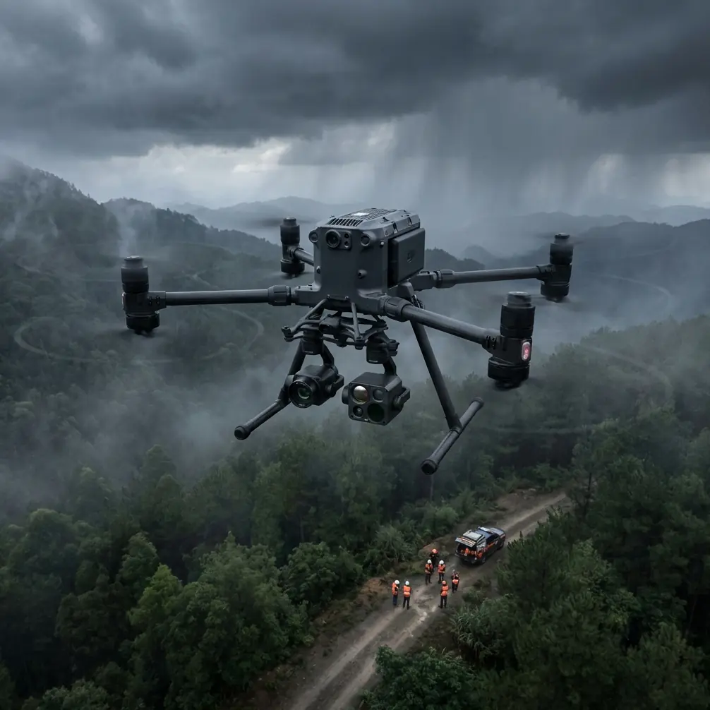
The mission profile: power-line mapping where terrain fights the link
In this case study scenario, the objective is a corridor survey over mixed elevation. The customer wants three deliverables from a single field campaign:
- Orthomosaic and corridor reconstruction for engineering review
- Thermal signature checks on selected components
- Repeatable documentation of pole, insulator, and conductor context for maintenance planning
This is exactly the sort of job where operators get tempted to chase speed. They load the aircraft, verify enough batteries, draw a route, and trust transmission strength to sort itself out. That works until the drone crosses a slope break, the line of sight partially collapses, and electromagnetic clutter around steel structures starts to degrade decision-making. You do not always lose control. Often the more expensive failure is subtler: hesitant positioning, interrupted image spacing, inconsistent overlap, or thermal data collected at the wrong angle and distance.
For power-line mapping, those errors are cumulative. A photogrammetry model can tolerate some noise, but corridor work in complex terrain depends on consistency. Your GCP strategy, your lens choice, your speed, and your overlap all rely on the aircraft behaving predictably over every segment of the route.
Why the electrical design reference actually matters to Matrice 400 crews
The aircraft design handbook reference is old-school in tone, but its logic is modern and valuable. It says system wiring should reflect actual installation positions, and the drawing layout should correspond to real aircraft layout. In the source, the left side of the drawing is conventionally treated as the aircraft front, the right as the rear, with spatial orientation preserved for clarity. Again, that sounds like a drafting office detail. In practice, it is the same discipline that separates reliable drone payload integration from improvised field builds.
On a Matrice 400 platform configured for mapping power lines, that means every powered accessory and data path should be documented as if someone else will have to troubleshoot it in poor weather next month. Payload power source. Connector type. Cable route. Shielding. Grounding point. Control assignment. Internal box-to-box relationships. The reference explicitly notes that internally designed panels, control boxes, and distribution panels should have all internal components drawn by enclosure, with detailed wiring relationships shown. That level of detail is operational gold when a field crew starts adding mapping sensors, thermal payloads, or custom data modules.
The significance is simple: when transmission quality dips near a tower and the operator sees intermittent payload behavior, you need to know whether the problem is external interference, antenna geometry, or an integration fault. If your system documentation is weak, every anomaly becomes guesswork.
Electromagnetic interference is not a theory problem
The narrative spark here is antenna adjustment, and rightly so.
Around transmission corridors, crews often blame “interference” too broadly. Sometimes the issue is true electromagnetic influence from the environment. Sometimes it is poor antenna orientation relative to aircraft position. Sometimes it is terrain masking that changes multipath behavior. The Matrice 400’s transmission system may offer robust long-range performance, but signal robustness still depends on how the operator presents the link to the airframe.
In steep terrain, the best crews do not just watch bars on the screen. They actively manage antenna angle as the aircraft moves from lateral corridor alignment to elevated ridge crossings or descends into a cut. A small ground-side adjustment can stabilize the link enough to preserve image cadence and command response. That is not glamorous fieldcraft, but on a corridor mission it can save an entire segment from having to be reflown.
This becomes even more relevant when the mission demands O3 transmission performance under non-ideal geometry. Real utility work is not a brochure environment. Towers and terrain force odd headings. The aircraft may momentarily present a less favorable orientation to the controller. Vegetation and topography can compress your clean line-of-sight window. If the operator understands antenna discipline, the transmission system can do its job. If not, even a strong platform gets judged unfairly.
Data security and transmission stability are part of the same conversation
Utility companies are more sensitive than ever about infrastructure imagery and asset records. That is why AES-256 matters in this kind of workflow. Not as a marketing badge, but as one piece of a chain that protects operational data during capture and transmission. Secure transport is especially relevant when you are collecting thermal signature information and high-resolution corridor imagery that may reveal asset condition, access routes, or maintenance priorities.
But security without reliability is incomplete. A clean encrypted link still has to remain stable enough to support the mission profile. For the Matrice 400 crew, that means mission planning cannot be separated from transmission planning. You do not just define waypoints. You define where signal geometry will tighten, where a handoff in body position may be needed, where ridges can create shadowing, and where a temporary hover for antenna correction may preserve the entire photogrammetry run.
Hot-swap batteries change the economics of corridor work
Power-line mapping missions are rarely neat one-battery jobs, especially in broken terrain where conservative speed and careful positioning matter more than theoretical maximum coverage. This is where hot-swap batteries earn their keep.
On paper, battery exchange is routine. In the field, the difference between a cold restart workflow and a hot-swap-capable platform is mission continuity. Corridor operations often depend on maintaining temporal consistency in lighting, wind behavior, and thermal conditions. The faster the aircraft can return to the same work envelope after a battery event, the cleaner the dataset tends to be.
That matters for both visual mapping and thermal checks. Thermal signature review can shift noticeably as sunlight angle changes or surfaces heat unevenly. If you lose too much time between segments, comparison quality drops. A platform that supports fast turnaround helps preserve the validity of cross-segment analysis.
Photogrammetry over power lines needs more than overlap numbers
A lot of corridor mapping advice becomes shallow very quickly. People talk about front overlap, side overlap, and GCP placement as if these are fixed recipes. They are not.
In complex terrain, the Matrice 400 mission should be designed around changing elevation and the vertical structure of the corridor itself. Conductors, towers, and surrounding vegetation create mixed-depth scenes that stress photogrammetric reconstruction. If the aircraft hesitates due to poor transmission handling, image spacing becomes irregular. If terrain causes inconsistent standoff distance, ground sampling distance shifts across the route. If the crew underestimates cross-slope winds, the aircraft may preserve the route but distort image angle consistency.
This is why the electrical-system reference about consistent numbering and interface marking is so relevant conceptually. The mission succeeds when every part of the chain is traceable. Flight path logic. Payload settings. GCP locations. Antenna behavior at difficult segments. Battery swap timing. Sensor mode changes. If one section of the corridor reconstructs poorly, the crew should be able to work backward and see exactly what changed.
That is the difference between professional utility mapping and simple aerial image collection.
The overlooked value of interface discipline
The handbook source says that when a wire connects to another system, the drawing should identify the related drawing number, page, zone, line number, and circuit characteristic. In drone work, the same principle should govern payload and workflow integration.
If your Matrice 400 is carrying a thermal unit alongside a mapping payload, define every interface clearly:
- Which control channel governs sensor mode
- Which storage path receives each dataset
- Which time synchronization method aligns imagery
- Which post-processing folder structure maps to each flight segment
- Which flight ID corresponds to which corridor span
Why does this matter operationally? Because a utility customer does not care that your team was “pretty sure” the thermal stills from the west-facing slope belong to sortie three. They care that each image is defensible, correctly located, and usable for engineering review.
That level of rigor becomes even more critical if the mission edges toward BVLOS frameworks under approved civil procedures. Once distance and route complexity increase, the tolerance for undocumented improvisation drops sharply.
A note on materials and payload installation quality
The second reference, focused on aircraft materials and flammability standards, includes a specific threshold: aircraft with seating capacity of 20 or more have added lower-fuselage insulation burnthrough requirements under Appendix F Part VII, with regulatory changes dated July 31, 2003. The testing methods for flame propagation and burnthrough were also described as different from those in CCAR-25R3.
No, that does not mean a Matrice 400 operator needs to certify the drone like a transport aircraft. But the operational significance is still worth extracting. Aviation-grade thinking treats installed materials, cable coverings, insulation, ducts, edge coverings, and interfaces as safety-critical details, not cosmetic ones. For drone teams building custom payload mounts, cable sleeves, protective wraps, or enclosure inserts, this mindset is healthy. Materials near power distribution, battery interfaces, or high-heat electronics should be chosen with restraint and documented carefully. Aerial utility work does not excuse sloppy enclosure materials or ad hoc cable protection.
Good integration is not just about whether the payload turns on. It is about whether the aircraft remains maintainable, inspectable, and electrically clean over repeated field cycles.
What the best Matrice 400 utility crews do differently
After enough corridor projects, patterns emerge.
The strongest teams do not rely on the platform to compensate for weak process. They pre-brief difficult terrain sections. They define antenna adjustment triggers before launch. They document payload interfaces like an airworthiness-minded engineer, not a hobby technician. They use hot-swap efficiency to preserve environmental consistency. They secure data as a default, not an upgrade path. And when photogrammetry output degrades, they investigate the chain systematically instead of blaming the map engine.
If you are planning a similar workflow and need a second set of eyes on corridor design, payload layout, or transmission strategy, you can message our utility drone team here.
That kind of preparation pays off most when the mission gets messy, which power-line mapping usually does.
Final field takeaway
The Matrice 400 makes sense for complex terrain utility mapping not because one feature stands above all others, but because the platform can support disciplined operations across several layers at once: stable transmission handling, secure data movement, efficient battery turnover, and payload workflows that can be documented and repeated.
The deeper lesson from the reference material is even more useful than any hardware spec. Aircraft systems perform best when their relationships are explicit. Wiring must match the circuit logic. Interfaces must be identified. Component placement must reflect real installation. Materials and enclosures should be selected with safety in mind. Bring that mindset into drone utility work, and the Matrice 400 stops being just an aircraft you fly over power lines. It becomes a reliable surveying system you can trust when terrain, infrastructure, and signal conditions all start pushing back.
Ready for your own Matrice 400? Contact our team for expert consultation.