Expert Venue Mapping with Matrice 400 in Wind
Expert Venue Mapping with Matrice 400 in Wind
META: Master venue mapping in windy conditions using the Matrice 400. Expert tips on antenna positioning, flight planning, and achieving survey-grade accuracy despite challenging weather.
TL;DR
- Matrice 400's wind resistance up to 15 m/s enables reliable venue mapping when other drones ground themselves
- Proper antenna positioning can extend O3 transmission range by 30-40% in challenging RF environments
- Hot-swap batteries eliminate downtime during multi-hour venue surveys
- Strategic GCP placement combined with photogrammetry workflows delivers sub-centimeter accuracy even in gusty conditions
The Wind Problem Every Venue Mapper Faces
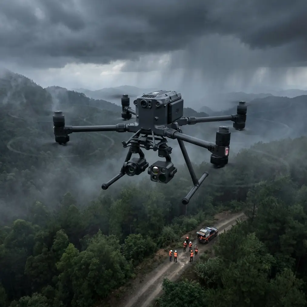
Wind kills venue mapping projects. You've scheduled the survey, coordinated site access, assembled your team—then 20 km/h gusts roll in and your consumer drone becomes a liability. The Matrice 400 changes this equation entirely.
This guide breaks down exactly how to leverage the Matrice 400's robust design for venue mapping when conditions turn challenging. You'll learn antenna positioning techniques that maximize range, flight planning strategies that account for wind patterns, and workflow optimizations that deliver photogrammetry-ready datasets regardless of weather.
Why Venue Mapping Demands Wind-Resistant Platforms
Venues present unique mapping challenges that compound in windy conditions. Large stadiums, amphitheaters, and event spaces create their own microclimates. Wind accelerates around curved structures, creates turbulence zones near seating areas, and generates unpredictable downdrafts over open fields.
The Structural Wind Effect
When wind encounters a stadium or arena, it doesn't simply flow over. The structure forces air into complex patterns:
- Acceleration zones form at building corners where wind speed can double
- Turbulence pockets develop in seating bowl areas
- Venturi effects occur in tunnels and concourse openings
- Thermal updrafts rise from sun-heated surfaces, creating vertical instability
Consumer drones struggle with these conditions because their lightweight frames lack the inertia to maintain stable positioning. The Matrice 400's increased mass and advanced stabilization algorithms compensate for sudden gusts that would send smaller aircraft into recovery mode.
Expert Insight: When mapping venues, I always conduct a "wind walk" before flying. Spend 15 minutes walking the perimeter with a handheld anemometer. You'll identify acceleration zones that don't appear on weather forecasts but will absolutely affect your flight.
Antenna Positioning for Maximum O3 Transmission Range
The Matrice 400's O3 transmission system delivers exceptional range—but only when antenna positioning works with you, not against you. In venue environments filled with metal structures, concrete, and RF interference from broadcast equipment, proper antenna technique becomes critical.
The 45-Degree Rule
Position your controller antennas at 45-degree angles relative to the aircraft's expected position. This orientation ensures at least one antenna maintains optimal signal reception regardless of the drone's heading during mapping runs.
Ground Station Placement Strategy
Where you stand matters as much as how you hold the controller:
- Elevate your position whenever possible—even standing on a vehicle bed adds valuable line-of-sight
- Avoid metal structures within 3 meters of your operating position
- Face the venue center rather than tracking the aircraft with your body
- Keep the controller chest-height with antennas pointing toward the sky at opposing angles
RF Environment Considerations
Venues often contain broadcast infrastructure that creates interference. Before mapping:
- Request a frequency coordination list from venue management
- Identify active broadcast frequencies that might conflict with 2.4 GHz or 5.8 GHz bands
- Consider early morning flights when broadcast equipment remains dormant
- The Matrice 400's AES-256 encryption maintains link security, but interference still degrades signal quality
Pro Tip: Carry a portable spectrum analyzer during venue surveys. A quick scan reveals RF congestion that's invisible until your video feed starts breaking up at the worst possible moment. The investment pays for itself after one saved mission.
Flight Planning for Windy Venue Surveys
Effective wind management starts before takeoff. Your flight plan must account for conditions that change throughout the mission.
Wind-Aware Mission Design
| Planning Factor | Calm Conditions | Moderate Wind (8-12 m/s) | High Wind (12-15 m/s) |
|---|---|---|---|
| Overlap (Front) | 75% | 80% | 85% |
| Overlap (Side) | 65% | 70% | 75% |
| Flight Speed | 8-10 m/s | 6-8 m/s | 4-6 m/s |
| Altitude AGL | Mission-dependent | +10% buffer | +15% buffer |
| Battery Reserve | 25% | 30% | 35% |
Crosswind Compensation Techniques
When mapping linear venue features like grandstands or concourses, orient your flight lines perpendicular to prevailing wind rather than parallel. This approach:
- Reduces drift correction demands on the gimbal
- Maintains consistent ground sampling distance
- Prevents the aircraft from fighting headwinds on return legs
- Optimizes battery consumption across the mission
Hot-Swap Battery Protocol
The Matrice 400's hot-swap battery capability transforms multi-hour venue surveys. Develop a rhythm:
- Land with 35% remaining on the active battery set
- Swap batteries within the 90-second hot-swap window
- Resume mission from the last captured waypoint
- Rotate battery sets through charging stations continuously
This protocol enables continuous operation without mission interruption—critical when weather windows are limited.
Photogrammetry Workflow Optimization
Capturing images is only half the challenge. Processing wind-affected datasets requires adjusted workflows to achieve survey-grade accuracy.
GCP Placement for Venue Environments
Ground Control Points anchor your photogrammetry model to real-world coordinates. In venues:
- Place GCPs on stable, permanent surfaces—avoid painted lines that may shift seasonally
- Distribute points across multiple elevation levels (field level, concourse, upper deck)
- Use high-contrast targets visible from mapping altitude
- Document GCP coordinates with RTK-grade GNSS receivers
- Minimum 5 GCPs for basic accuracy; 8-12 GCPs for sub-centimeter precision
Thermal Signature Considerations
Venue surfaces exhibit varying thermal signatures that affect image quality during processing:
- Metal roofing creates hot spots that can bloom in imagery
- Synthetic turf maintains consistent thermal properties
- Concrete seating shows thermal gradients based on sun exposure
- Glass facades produce reflections that confuse photogrammetry algorithms
Schedule flights during overcast conditions or early morning hours when thermal differentials minimize. If thermal imaging is part of your deliverable, these same differentials become assets rather than obstacles.
Processing Wind-Affected Datasets
Wind introduces subtle motion blur and positioning inconsistencies. Compensate during processing:
- Increase tie point detection sensitivity by 15-20%
- Enable rolling shutter compensation if using mechanical shutter alternatives
- Review alignment reports for outlier images captured during gusts
- Consider excluding images with blur detection scores below threshold
BVLOS Considerations for Large Venue Surveys
Many venue mapping projects push beyond visual line of sight. The Matrice 400's capabilities support BVLOS operations, but regulatory and safety requirements demand careful planning.
Regulatory Framework
Before conducting BVLOS venue surveys:
- Obtain appropriate waivers or approvals from aviation authorities
- Coordinate with venue security and local air traffic control
- Establish visual observer networks for extended operations
- Document emergency procedures specific to the venue environment
Communication Protocols
BVLOS operations require robust communication:
- Primary: O3 transmission link with controller
- Secondary: Cellular backup connection
- Tertiary: Radio communication with visual observers
- Emergency: Predetermined lost-link behavior and return-to-home protocols
Common Mistakes to Avoid
Ignoring microclimate variations: Weather apps show regional conditions, not the specific wind patterns your venue creates. Always verify on-site.
Antenna orientation neglect: Pointing both antennas straight up seems intuitive but sacrifices signal diversity. Maintain the 45-degree spread.
Insufficient overlap in wind: Standard overlap percentages assume stable flight. Wind-induced drift demands increased overlap to maintain processing quality.
Skipping the wind walk: Fifteen minutes of ground observation prevents hours of frustration during flight operations.
Rushing hot-swap procedures: The 90-second window feels generous until you fumble a battery connection. Practice the swap sequence until it becomes automatic.
Ignoring RF environment: Venue broadcast infrastructure operates on schedules you won't know without asking. Coordinate with facility management.
Frequently Asked Questions
What wind speed threshold should ground Matrice 400 venue mapping operations?
While the Matrice 400 handles sustained winds up to 15 m/s, venue mapping quality degrades significantly above 12 m/s. Gusts create the real limitation—if gusts exceed 18 m/s, even brief exposure risks image quality issues. Monitor both sustained and gust speeds, grounding operations when either approaches limits.
How does GCP density affect accuracy in large venue surveys?
GCP density directly correlates with absolute accuracy. For venues under 50,000 square meters, 8 GCPs distributed across the site typically achieve 2-3 cm horizontal accuracy. Larger venues or those requiring sub-centimeter precision need 12-15 GCPs with emphasis on elevation distribution across multiple venue levels.
Can thermal imaging and RGB photogrammetry run simultaneously during venue surveys?
The Matrice 400 supports multi-sensor payloads, but simultaneous capture requires careful mission planning. Thermal and RGB sensors have different optimal capture parameters—thermal benefits from slower speeds and specific temperature differentials, while RGB photogrammetry prioritizes consistent lighting. Consider separate passes optimized for each sensor type rather than compromising both in a single flight.
Ready for your own Matrice 400? Contact our team for expert consultation.