Matrice 400 for Coastal Venue Mapping: What Actually
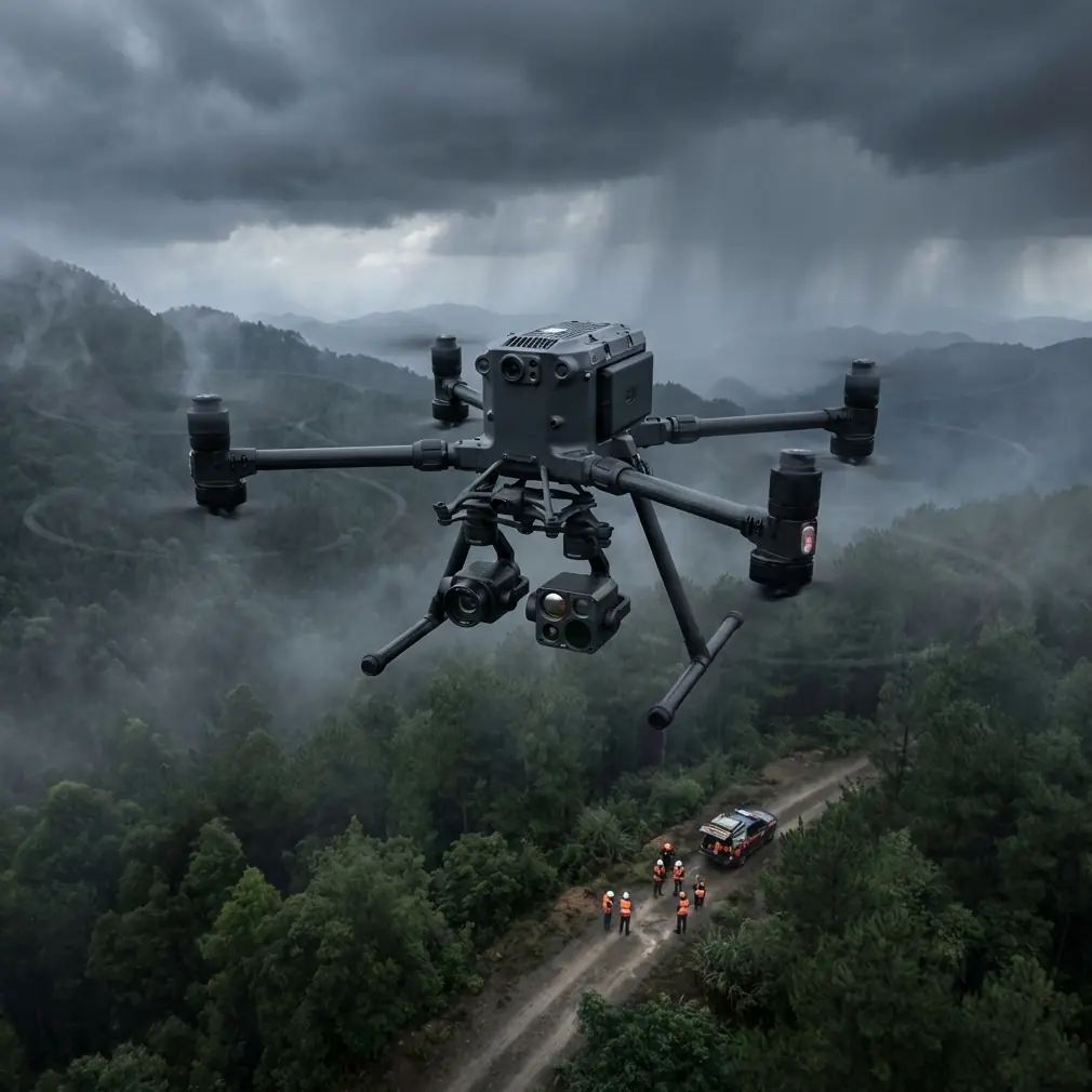
Matrice 400 for Coastal Venue Mapping: What Actually Matters in the Field
META: Expert guide to using the DJI Matrice 400 for coastal venue mapping, with practical insight on thermal sensing, photogrammetry, GCP workflows, O3 transmission, AES-256 security, hot-swap batteries, and BVLOS planning.
Coastal venue mapping looks straightforward on a screen. A few passes over a shoreline property, stitch the imagery, build the model, deliver the map. On site, it rarely behaves that cleanly.
Salt haze softens contrast. Wind pushes harder than the forecast suggested. Reflective water confuses visual references. Temporary structures appear overnight for weddings, festivals, or seasonal events. Wildlife moves through the same airspace you planned to use. If the mission is tied to access roads, drainage planning, emergency routes, or event layout, small errors become expensive fast.
That is where the Matrice 400 becomes interesting—not as a generic enterprise drone, but as a tool that solves a very specific set of coastal mapping problems when the mission is planned correctly.
For venue operators, survey teams, and drone service providers working along the coast, the value of the platform is not just lift capacity or endurance on a spec sheet. It is the way a few core capabilities work together in difficult environments: stable photogrammetry flights in variable conditions, resilient transmission, secure data handling, continuous operations through hot-swap batteries, and payload flexibility that helps crews adapt when the site throws up surprises.
The real problem with coastal venue mapping
Most mapping errors in coastal environments do not begin in processing. They begin in capture.
A shoreline venue often combines several hard-to-map surfaces in one compact area: open sand, paved access roads, sea walls, landscaping, rooftops, marina edges, temporary tents, and water boundaries. Each one behaves differently under changing light. Add tidal movement and airborne moisture, and the “same site” can look materially different between morning and afternoon.
Photogrammetry depends on consistency. The aircraft needs predictable overlap, stable positioning, and imagery with enough texture to generate reliable tie points. Coastal sites fight all three.
This gets more complicated when the mission is not a pure surveying job. Venue mapping is usually operational. The client may need a base map for event planning, a 3D model for drainage redesign, a thermal scan for roof moisture intrusion near the seafront, and an updated perimeter dataset for security planning. That means the aircraft is not just flying one neat grid. It may be switching from nadir capture to oblique work, then to thermal inspection, while maintaining continuity in the data.
The Matrice 400 fits this kind of assignment because it supports a modular workflow rather than a one-task-only workflow. In coastal operations, that distinction matters.
Why transmission reliability matters more than most teams admit
A lot of mapping discussions fixate on sensors and forget the link.
On a coastal site, the command-and-video link is not a background feature. It is operational infrastructure. Open waterfront areas can create deceptively easy flight conditions visually, yet still expose the mission to signal complexity from long sightlines, reflective surfaces, and interference around event infrastructure or nearby urban edges.
That is why O3 transmission deserves more attention in a mapping conversation. Reliable transmission is not just about “seeing farther.” It affects confidence in live framing, obstacle awareness, payload control, and decision-making when the wind line over the water behaves differently from the wind line over land.
For venue mapping, this becomes especially important at the edge cases: a boardwalk section near the surf, a rooftop hospitality deck, or a service corridor behind temporary installations. If the pilot can maintain a cleaner, more stable link, the team spends less time repeating partial flight lines or second-guessing whether image quality degraded during the run.
That directly improves deliverables. Fewer interrupted passes mean more consistent overlap. More consistent overlap means cleaner photogrammetry outputs and fewer reconstruction defects in critical surfaces such as retaining walls, stair structures, and shoreline barriers.
Security is not a side issue on venue projects
The other detail many operators overlook is data sensitivity.
Venue maps are not always simple topographic products. They can reveal access points, utility layouts, private guest areas, staging zones, and security perimeters. If the site hosts public events, private functions, or high-profile gatherings, the mapping dataset may be far more sensitive than a standard land survey.
This is where AES-256 support matters in practical terms. Strong encryption is not just a compliance checkbox. It helps protect live mission data and transmission integrity when teams are collecting imagery over properties that have real privacy and security concerns.
For coastal venues tied to hospitality or event operations, that matters twice. First, the geography itself can expose the site to public view from adjacent beaches, marinas, or roads. Second, project stakeholders often include multiple parties—property managers, planners, engineers, security consultants, and contractors. The more hands in the workflow, the more important secure handling becomes from capture onward.
The Matrice 400’s value here is not abstract. It supports a more credible chain of custody for sensitive visual and thermal data.
A wildlife moment that changes how you fly
One of the more revealing moments in coastal mapping is when the site reminds you it is not only a work zone.
On a dawn shoreline mission for a venue expansion layout, a flock of oystercatchers lifted from the tideline just as the aircraft transitioned toward a lower-altitude pass near a dune-backed reception area. At nearly the same time, thermal sensing picked up a distinct heat signature along scrub vegetation beside a service track—likely a small mammal moving out of the morning chill. Neither was dramatic. Both mattered.
That single moment changed the flight profile.
Instead of pressing the original route, the crew widened the buffer, altered the pass direction, and delayed the low oblique segment until the birds cleared the area naturally. The thermal signature was useful not because it identified a species with certainty, but because it revealed active biological presence where the visual feed alone might not have prompted caution quickly enough.
This is where thermal capability earns its place in a coastal venue workflow. People often think of thermal only in inspection terms: roofs, electrical equipment, search tasks. In practice, thermal can help crews interpret site activity and avoid unnecessary disturbance, especially in low-light windows when wildlife movement is more pronounced.
Operationally, that means safer missions and fewer interruptions. It also means the aircraft can support a more responsible survey practice in environmentally sensitive zones, which is often a real issue near dunes, marsh edges, and protected shoreline habitats.
Photogrammetry still wins the core mapping job—if you support it properly
For all the attention on advanced sensing, the backbone of venue mapping is still disciplined photogrammetry.
The Matrice 400 is most effective when teams treat it as a precision capture platform rather than a “fly-and-fix-it-later” machine. Coastal sites punish lazy data collection. If you want a usable orthomosaic and a 3D model that planners can trust, your mission design must be tighter than it would be inland.
Ground control points matter here. GCP deployment is not glamorous, but it remains one of the clearest ways to stabilize accuracy when the site includes repetitive textures, low-contrast sand, and boundaries that shift visually near water. A venue team trying to place fencing, emergency egress routes, or utility trenches needs confidence in positional reliability, not just a pretty map.
In a coastal workflow, a strong approach often looks like this:
- Establish GCPs well outside likely tidal influence.
- Capture with conservative overlap rather than minimum overlap.
- Use nadir mapping for the base model, then add targeted obliques where structures matter.
- Re-fly only the problem area, not the whole mission, if environmental conditions change.
- Pair visible-light outputs with thermal layers when the project includes asset condition or drainage questions.
The Matrice 400 supports this kind of repeatable method because it is built for extended, professional flight operations rather than occasional short-form capture. That distinction becomes obvious halfway through a demanding site day.
Hot-swap batteries are not just a convenience
Battery changes are where a lot of field momentum disappears.
On coastal venue projects, crews often work within narrow windows: low tide, low crowd presence, favorable sun angle, acceptable wind, and site access that may close once event setup begins. If an aircraft forces a full reset every time power changes, the mission loses rhythm and consistency.
Hot-swap batteries matter because they preserve the workday. They reduce downtime, keep crews inside the best environmental window, and make it more realistic to complete large or multi-phase venue datasets without splitting the job into too many separate sessions.
That has a technical upside, not just a scheduling one. Fewer prolonged interruptions can mean more consistent lighting across a capture set. More consistent lighting improves the quality of photogrammetry reconstruction, especially on mixed surfaces such as tents, decking, light-colored paving, and landscaped edges.
For coastal assignments, where haze and glare can shift quickly, maintaining continuity is a bigger advantage than many teams realize.
BVLOS planning changes the scale of what is feasible
Not every venue mission requires BVLOS operations, and crews should never treat the concept casually. But in larger coastal properties or connected shoreline developments, BVLOS planning can reshape how efficiently the work gets done.
Think of a mapping brief that spans a main event venue, overflow parking, coastal access roads, drainage channels, and neighboring shoreline buffers. Under the right regulatory framework and with appropriate procedures, BVLOS-capable planning allows the mission to be designed around the site’s actual geography rather than around a series of fragmented visual-line segments.
This matters because fragmentation creates seams—in flight execution, in overlap consistency, and often in the final dataset.
The Matrice 400 sits comfortably in that conversation because it brings together the kind of transmission resilience, operational endurance, and enterprise-level control architecture that larger site workflows demand. Even when the mission remains strictly within visual line of sight, planning with BVLOS discipline tends to improve the result: clearer contingencies, stronger communications, better airspace awareness, and more rigorous route design.
In other words, the platform rewards mature operating practices.
The better way to map a coastal venue with the Matrice 400
If the assignment is coastal venue mapping, the smartest use of the Matrice 400 is not to throw every payload and feature at the site. It is to build a sequence.
Start with the base deliverable. Usually that means a clean, survey-ready photogrammetry mission anchored by properly placed GCPs. Then identify what the base map will miss: roof moisture patterns, thermal anomalies in utility areas, shoreline encroachment concerns, or temporary infrastructure that needs oblique modeling. Use the aircraft’s sensor and endurance advantages to fill those gaps deliberately.
That sequence solves two common problems. First, it prevents data overload. Second, it keeps the mapping objective tied to operational decisions.
For example, if a coastal resort venue is redesigning pedestrian flow after storm damage, the core need may be topographic and structural, not cinematic. If a marina-side event space is struggling with drainage after high tide and rain overlap, thermal signature data may help identify moisture-retaining zones that a visible orthomosaic alone does not clarify. If a private waterfront venue needs perimeter planning, AES-256-secured capture and transmission become part of the project value, not a buried technical note.
The Matrice 400 is strong precisely because it can handle these adjacent demands without forcing the team into separate aircraft workflows.
If you are planning a mission and want to compare route logic or payload choices for a shoreline site, this direct project chat is a practical place to start.
What makes the platform relevant right now
Even without a fresh product announcement to react to, the Matrice 400 remains highly relevant because the missions around it are getting harder, not easier.
Venue owners want faster updates. Engineers want better spatial confidence. Security teams want tighter control of sensitive site data. Environmental awareness is under more scrutiny, especially in coastal zones. And drone operators are expected to deliver all of that with fewer site disruptions.
That combination is exactly where a platform like the Matrice 400 proves its worth.
Not by being flashy. By reducing friction.
Reliable O3 transmission helps keep complex shoreline flights stable. AES-256 helps protect sensitive venue and infrastructure data. Hot-swap batteries help teams stay productive inside narrow weather and access windows. Thermal sensing adds a layer of environmental awareness and asset intelligence that standard imagery cannot always provide. And disciplined photogrammetry, backed by GCPs, turns all of that into outputs people can actually use.
For coastal venue mapping, that is the real story. The drone is only half the equation. The other half is whether the aircraft helps a professional crew collect trustworthy data under conditions that are never as simple as they look from the parking lot.
Ready for your own Matrice 400? Contact our team for expert consultation.