Matrice 400 Mapping Tips for Vineyards in Complex Terrain
Matrice 400 Mapping Tips for Vineyards in Complex Terrain
META: Expert Matrice 400 vineyard mapping advice for steep terrain, photogrammetry accuracy, thermal workflows, transmission stability, and battery-efficient mission planning.
Vineyards punish weak drone workflows.
Rows curve with the slope. Elevation changes distort overlap. Wind accelerates over ridgelines, then drops into sheltered blocks. A mission that looks clean on a planning screen can produce uneven image density, soft edges on orthomosaics, and patchy thermal data once the aircraft starts climbing and descending through real terrain.
That is exactly where the Matrice 400 becomes interesting.
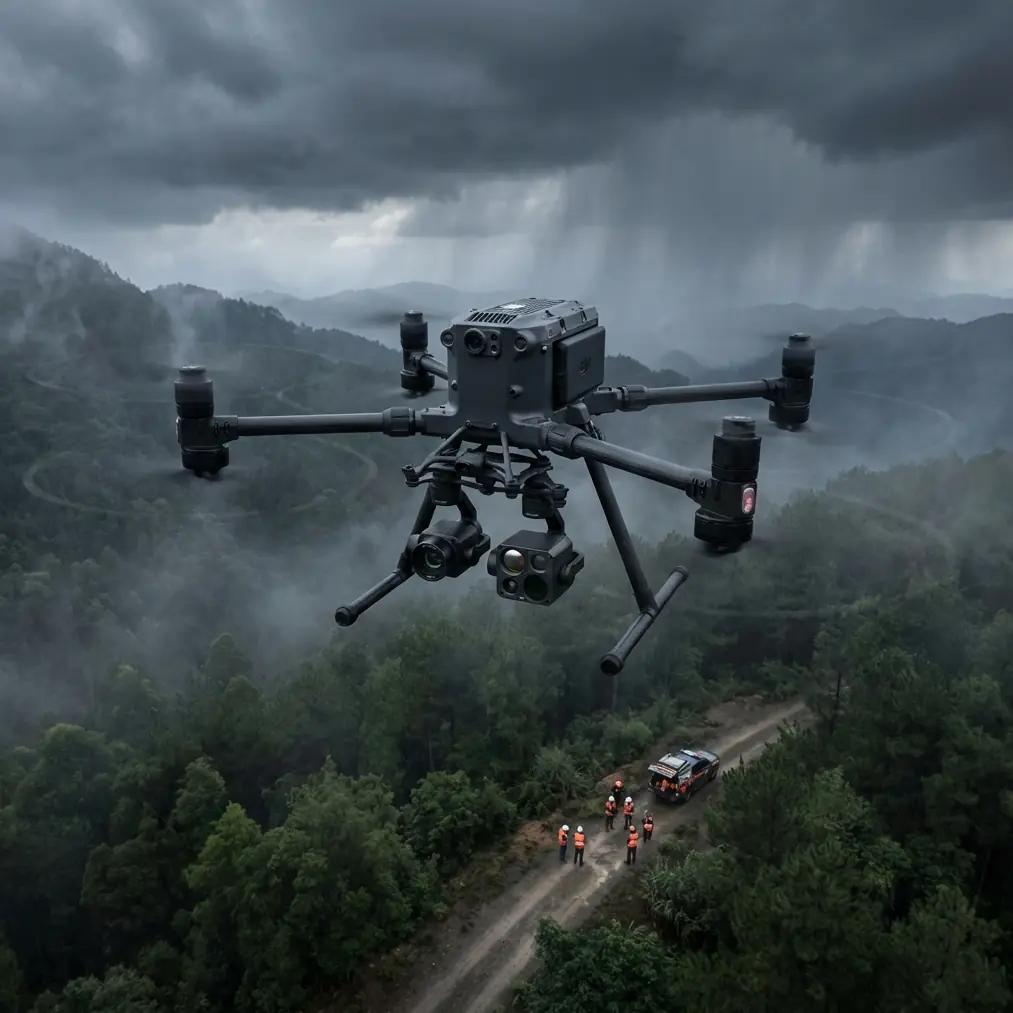
For vineyard operators, agronomy teams, and mapping specialists working in broken topography, the aircraft is not just a bigger platform. Its value is practical: more stable data capture over long blocks, stronger connectivity in obstructed terrain, and a power system that keeps operations moving when timing matters. If your goal is to build reliable photogrammetry products, compare thermal signatures across vine stress zones, or maintain repeatable seasonal surveys, the Matrice 400 is a serious tool for the job.
I’ll frame this the way most vineyard projects actually unfold: as a problem-solution exercise rather than a spec recital.
The real problem with mapping vineyards on steep or irregular ground
Flat farmland is forgiving. Vineyards in hills are not.
The first issue is terrain-induced inconsistency. Traditional mapping missions often assume relatively uniform ground clearance. On a hillside, that assumption breaks immediately. If the aircraft holds altitude relative to takeoff point rather than terrain, one section may be flown too high for the required ground sampling distance, while another may be too low for efficient coverage. That affects photogrammetry quality, especially along row transitions and terrace edges.
The second issue is signal reliability. Vineyards are often spread across valleys, ridgelines, and fragmented parcels with vegetation and structures interrupting line of sight. Even when you are operating legally within local rules, weak transmission can force conservative mission design, shorten effective working range, and increase pilot workload.
The third issue is operational continuity. Mapping windows in viticulture are often narrow. You may be trying to capture data before irrigation, after a weather change, or during a specific phenological stage when thermal differences are most useful. Every battery change interrupts momentum. Every reboot or delayed payload swap cuts into useful field time.
The fourth issue is data fusion. Vineyard managers increasingly want more than a pretty map. They want visible-band photogrammetry for canopy geometry, thermal signature analysis for stress detection, and georeferenced outputs that align cleanly with GCP-backed control points and prior surveys. Many aircraft can carry a sensor. Fewer fit naturally into a repeatable production workflow.
Why the Matrice 400 fits this terrain better than lighter competitors
A lot of competing platforms can complete a vineyard mission in ideal conditions. That is not the right standard.
The better question is: which aircraft stays consistent when the site is large, sloped, windy, and operationally messy?
This is where the Matrice 400 separates itself.
Its architecture favors endurance and mission continuity over the stop-start rhythm common with smaller systems. That matters more in vineyards than many teams expect. If you have ever stitched a large hillside block from multiple interrupted flights, you know the pain points: changing light, shifting wind, inconsistent overlap near battery return points, and extra time spent re-establishing the mission state. The Matrice 400’s hot-swap batteries directly address this. Operationally, hot-swapping means you can keep the aircraft workflow moving without the full reset cycle that slows teams using less field-oriented systems. On a multi-block vineyard survey, that can be the difference between completing all planned captures in stable morning light and having to split the job into another day with different environmental conditions.
That is not a small convenience. It affects data consistency.
Transmission strength is another area where the Matrice 400 stands out. DJI’s O3 transmission system has become one of the most operationally meaningful features for real survey work because it gives pilots and mission planners a more dependable link in places where topography and vegetation make connectivity unpredictable. In vineyard valleys or on estates broken up by terrain folds, stronger transmission reduces hesitation. It helps maintain command confidence and cleaner mission execution. For teams planning longer corridor-style or parcel-to-parcel flights, this is especially valuable. It also supports better situational awareness when you are managing payload data capture rather than simply watching the aircraft icon move across the map.
Security is often ignored in agriculture conversations until a large operator, consultant, or co-op asks the obvious question: how is flight and data communication being protected? Here, AES-256 matters. It is not a marketing flourish. For commercial operators handling geospatial outputs tied to land management, crop performance, or client property data, encrypted transmission is a practical requirement. If you are mapping premium vineyard assets or sharing mission operations across a distributed team, that level of communication security adds confidence without changing field behavior.
What this means for photogrammetry in vineyards
Photogrammetry in vineyards has two jobs.
One is geometric: build accurate orthomosaics, elevation models, and row-level site context.
The other is comparative: create repeatable visual records that can be assessed over time.
The Matrice 400 supports both because it is built to sustain stable, professional capture workflows instead of isolated short flights.
In complex terrain, repeatability is everything. You need consistent overlap, predictable speed, and enough endurance to avoid carving the job into too many disconnected segments. When missions are fragmented, row edges and sloped sections often become the weak spots in reconstruction. That leads to noisy outputs exactly where managers want clarity—erosion-prone slopes, drainage transitions, replant zones, and edge rows under variable stress.
For vineyard photogrammetry, I recommend treating the Matrice 400 as a terrain workflow platform, not simply a camera carrier. Plan with terrain awareness from the start. Use GCP placement strategically, especially where elevation changes sharply or where row orientation shifts across terraces. Good GCP distribution on a hillside does more than improve absolute accuracy; it stabilizes the entire block model and reduces the subtle distortions that can creep into long sloped reconstructions.
This is one place where operators often underestimate the aircraft’s advantage over smaller competitors. A lighter drone may be perfectly capable of collecting images in calm weather over a compact parcel. But when your site expands across uneven ground and the mission grows into a production task rather than a test flight, the Matrice 400’s endurance profile and field efficiency begin to show their value. You spend less energy managing the aircraft and more attention validating data quality.
Thermal signature mapping: useful, but only if captured correctly
Thermal work in vineyards is often oversimplified.
A thermal map is not automatically actionable. If the aircraft flies at inconsistent height over uneven terrain, if the timing drifts too late into the day, or if the mission is broken into too many discontinuous segments, apparent thermal variation may reflect capture inconsistency rather than plant behavior.
The Matrice 400 helps because it supports stable, longer-duration collection windows and reliable platform behavior in demanding conditions. For thermal signature analysis, that translates into cleaner comparison across blocks and fewer artifacts introduced by rushed field procedures.
Operationally, this matters when looking for canopy stress patterns, irrigation irregularities, blocked emitters, or drainage-related anomalies on slopes. In complex terrain, temperature differences can emerge from exposure, airflow, and soil moisture transitions. Thermal data is only useful if you can trust the context around it. Pairing thermal capture with visible-spectrum photogrammetry gives you that context. You can examine whether a hot zone aligns with canopy thinning, terrace edge runoff, row-end compaction, or a simple shadow transition.
My advice is to treat thermal and photogrammetry as complementary layers, not separate missions with separate logic. The Matrice 400 is well suited to that mindset because it is designed for serious payload operations and sustained field use. The result is a mapping workflow that serves agronomy decisions instead of generating disconnected image sets.
BVLOS relevance without drifting into hype
BVLOS is one of those terms people throw around too casually. In real vineyard operations, its significance depends entirely on regulation, waiver pathways, and operator competence.
Still, from a planning standpoint, BVLOS-readiness matters.
Large estates, distributed parcels, and long access roads create inefficiencies if every mission must be designed around minimal stand-off and constant repositioning. An aircraft platform that is operationally credible for advanced commercial workflows gives teams room to scale when the regulatory path exists. The Matrice 400 sits in that conversation naturally because it combines robust transmission, professional mission architecture, and security features aligned with enterprise deployment.
That does not mean every vineyard operator needs BVLOS tomorrow. It means choosing a platform that does not become the bottleneck if your program expands.
Field workflow that actually works on vineyard terrain
Here is the workflow I typically recommend for complex vineyard sites using a platform in the Matrice 400 class.
Start with block prioritization, not blanket coverage. Rank parcels by slope complexity, known vigor variability, irrigation history, and manager objectives. A large capable aircraft tempts teams to map everything. Resist that. Better mission design beats maximum acreage.
Next, place GCPs where terrain and decision-making intersect. Put control near elevation breaks, terrace transitions, access tracks, and drainage lines. If you place all your GCPs in convenient flat areas, the resulting model may look fine in overview and still underperform where the vineyard actually needs scrutiny.
Then fly your visible-band photogrammetry with generous overlap and terrain-aware planning. In vineyards, repetitive row geometry can confuse reconstruction if overlap is too thin or if image perspective changes too abruptly across slopes. Give the software enough information to model the site honestly.
Schedule thermal capture with discipline. Early enough to preserve meaningful contrast, but not so early that environmental stabilization is incomplete. Keep missions consistent across survey dates. Same block sequence. Similar weather windows. Similar altitude logic. The Matrice 400’s mission continuity and hot-swap battery workflow help here because they reduce the chance that your “repeat survey” becomes a different operational pattern every time.
Finally, evaluate outputs in relation to vine rows, not only parcel boundaries. Vineyard managers think in rows, sections, irrigation zones, rootstocks, and problem patches. A drone map becomes valuable when it speaks that language.
If your team is refining a vineyard mapping setup and wants to compare mission architecture before the next field cycle, this direct project discussion link is often the quickest way to sort out payload fit, overlap strategy, and terrain-specific planning questions.
Where the Matrice 400 is strongest for vineyard professionals
The Matrice 400 is at its best when the vineyard operation is no longer casual.
It excels when you need repeatable data products, not occasional imagery. It makes sense when your sites are topographically difficult, geographically spread out, or tied to serious crop management decisions. It is particularly strong for operators combining orthomosaic production, elevation modeling, and thermal signature review into a single seasonal monitoring program.
Compared with smaller competitors, its edge is less about headline excitement and more about reduced friction. Fewer workflow interruptions. Stronger transmission confidence through uneven terrain. Better alignment with enterprise security expectations through AES-256. Smoother battery management with hot-swap capability. A more natural fit for advanced commercial operations that may eventually include BVLOS-authorized mission structures where regulations permit.
Those details add up.
And in vineyards, small field inefficiencies become expensive quickly. A retransmitted mission, a broken capture sequence, or a weak model on the steepest parcel is not just inconvenient. It can delay canopy management decisions and undermine trust in the whole mapping program.
The practical takeaway
If you are mapping vineyards in complex terrain, the wrong aircraft forces you to constantly compensate for its limitations. The right one lets you focus on agronomic questions and geospatial quality.
That is the strongest case for the Matrice 400.
Not that it flies. Many drones fly.
The point is that it supports the kind of disciplined, repeatable, professional mapping workflow that hillside vineyards demand. O3 transmission helps maintain control confidence in difficult terrain. AES-256 supports secure enterprise operations. Hot-swap batteries preserve momentum and data consistency over large survey areas. And when combined with sound GCP strategy, terrain-aware planning, and a disciplined thermal workflow, the platform becomes more than a survey aircraft. It becomes infrastructure for vineyard decision-making.
Ready for your own Matrice 400? Contact our team for expert consultation.