How I’d Map Wildlife in Complex Terrain With the Matrice 400
How I’d Map Wildlife in Complex Terrain With the Matrice 400
META: A field-tested how-to for using the Matrice 400 to map wildlife in steep, complex terrain with thermal sensing, photogrammetry, secure transmission, and efficient battery strategy.
When wildlife mapping moves from open grassland to broken ridgelines, tree cover, ravines, and shifting weather, the aircraft matters far less than the workflow built around it. That is where the Matrice 400 becomes interesting. Not because bigger numbers automatically create better conservation outcomes, but because difficult terrain punishes weak links: unstable transmission, awkward payload changes, poor battery handling, and inconsistent geospatial capture.
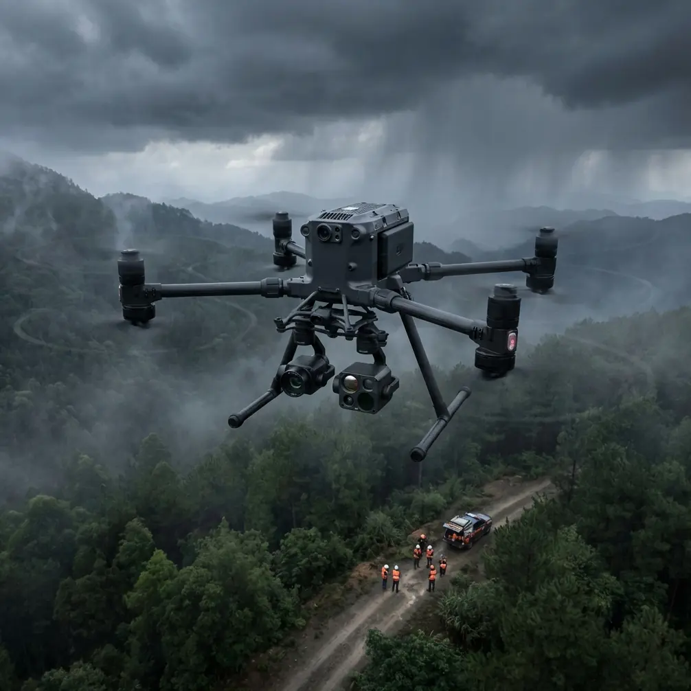
I approach the Matrice 400 as a mission platform rather than a camera with propellers. For biologists, environmental consultants, and reserve managers working in complex terrain, that distinction changes everything. The goal is not simply to fly. The goal is to return with defensible habitat maps, repeatable animal location data, and imagery that still holds up when a field team compares one survey window against the next.
A recent planning scenario I often use with teams involves surveying a mixed alpine-forest corridor where a small herd of wild goats moved between rock shelves just above a conifer line. The visible-light view was cluttered by branches and shadow. A thermal signature appeared intermittently as the animals crossed sun-warmed stone and dipped into cooler cover. That sort of encounter is where a platform like the Matrice 400 earns its place: not in ideal conditions, but when target detection, positional confidence, and mission continuity all start competing with each other.
Start with the survey objective, not the flight line
Wildlife mapping missions usually collapse into one of three tasks:
- locating animals,
- mapping habitat condition,
- building georeferenced models for later analysis.
The mistake is treating all three as the same sortie. They are not. If I were building a Matrice 400 workflow in complex terrain, I would split the operation into separate mission layers.
The first layer is detection. This is where thermal sensing matters most. In steep terrain, visual spotting alone is unreliable because slope aspect, canopy gaps, and rock shadows distort contrast. A thermal payload helps isolate living targets against clutter, especially in early morning or late-day windows when the ground and vegetation are not radiating as aggressively. The operational significance is straightforward: thermal lets you find probable animal positions faster, which reduces low-value flight time and preserves battery reserves for the mapping passes that actually create usable datasets.
The second layer is photogrammetry. Once target zones or movement corridors are identified, the mission shifts from detection to documentation. Now the aircraft needs stable pathing, predictable image overlap, and enough endurance to cover elevation changes without forcing rushed compromises. In rugged wildlife terrain, photogrammetry fails less often because of software than because of terrain-induced inconsistency. The Matrice 400’s value in this phase is the way it supports a methodical survey cadence instead of a hurried one.
The third layer is verification. That means returning to ambiguous hotspots, checking thermal anomalies, and validating whether a heat source was an animal, exposed rock, recent ground disturbance, or even a human presence near a protected corridor. Good wildlife mapping is full of second looks.
Build a terrain-aware photogrammetry plan
Photogrammetry in flat farmland is one discipline. Photogrammetry across gullies and escarpments is another. With the Matrice 400, I would structure the mission around terrain behavior first.
Begin with a terrain segmentation pass. Divide the area into slope classes rather than simple rectangular blocks. Ridge tops, forest breaks, cliff bands, water channels, and valley pockets each produce different image geometry and lighting problems. That matters because a single uniform altitude strategy can quietly ruin reconstruction quality. If one portion of the site sits hundreds of feet below the launch point and another rises sharply toward the aircraft, your ground sampling distance and overlap consistency drift fast.
This is where GCP planning comes in. Ground control points are not glamorous, but they separate pretty imagery from data you can defend. In wildlife projects, especially those tied to habitat restoration or species movement analysis, positional accuracy matters because the final map often needs to align with trail surveys, vegetation plots, or historic monitoring grids. I would place GCPs where terrain transitions are strongest: ridge shoulders, open clearings near canopy boundaries, and stable surfaces visible from multiple headings. In steep country, evenly spaced control looks neat on paper but often performs worse than strategically weighted control near the hardest geometry.
The Matrice 400 becomes useful here because it supports a more disciplined sequence: detect, segment, map, verify, then revisit without rebuilding the whole mission from scratch.
Use thermal intelligently, not continuously
Thermal is one of the most misused tools in wildlife work. Operators often assume that if the thermal feed is available, it should drive the whole mission. That is rarely efficient.
A thermal signature is strongest when it answers a specific question. Is there an animal present under canopy edge? Did movement occur along that scree line? Is the heat source stationary, dispersed, or grouped? In the mountain-goat scenario I mentioned earlier, the thermal feed was not useful because it produced a beautiful image. It was useful because it revealed two animals paused in partial cover where the visual sensor kept blending them into the rock face. That changed the next leg of the survey. Instead of wasting flight time chasing the entire ridge, the team could tighten the mapping box around the actual movement corridor.
Operationally, that means thermal should guide your priorities, while photogrammetry produces the archive-quality layer. That pairing is especially strong in complex terrain because heat can reveal presence while the visible-light model explains terrain use. One dataset tells you where an animal was. The other helps explain why.
Protect continuity with hot-swap batteries
Wildlife mapping rarely respects a clean battery schedule. Animals move. Wind shifts. Shadows change. A site that looked straightforward from a planning screen may require extra verification passes once you are airborne.
That is why hot-swap batteries matter in the field. Their real value is not convenience. It is continuity. If a survey team can keep the aircraft mission-ready during battery changes, they reduce downtime during the narrow windows when animals are active and environmental contrast is favorable. On a mountain wildlife mission, twenty extra minutes of delay can mean losing the thermal separation that made detection possible in the first place.
For conservation crews working in remote terrain, battery handling also changes staffing pressure. Fewer interruptions mean fewer rushed decisions at the edge of a cliff, beside a vehicle track, or in a temporary launch zone with limited shelter. Good aircraft systems do not just improve data. They improve field behavior.
Do not overlook transmission integrity
Transmission quality becomes a safety and data issue long before it becomes an inconvenience. Complex terrain is notorious for swallowing signal through line-of-sight interruptions, rock shielding, and dense vegetation. That is why O3 transmission capability is not just a spec-sheet detail. In wildlife work, it directly affects how confidently an operator can maintain situational awareness as the aircraft works around terrain features.
If I were running a Matrice 400 mission in canyon-cut habitat or heavily folded uplands, I would treat transmission planning as part of route design. Launch position, relay expectations, altitude margins, and return contingencies need to be considered before takeoff. The reason is simple: survey quality drops the moment the pilot begins flying conservatively because the link feels uncertain. Operators shorten passes, avoid valuable angles, and leave mapping gaps. A robust transmission system helps preserve mission discipline.
The same logic applies to AES-256 security. Wildlife mapping is not always just ecology. Some missions involve protected species, anti-poaching operations, sensitive nesting zones, or restricted land use studies. Secure transmission matters because location data for vulnerable animals should not be casually exposed. That is the operational significance of AES-256 in this context: it helps protect the integrity of sensitive environmental information while teams work in the field or move data through organizational workflows.
Prepare for BVLOS requirements before the mission, not during it
BVLOS enters the discussion quickly in wildlife operations because animal corridors do not stop where visual line of sight becomes inconvenient. Large valleys, winding forest tracks, and inaccessible slopes often make traditional visual operations inefficient.
That does not mean every wildlife survey should be flown BVLOS. It means the Matrice 400 should be integrated into a compliance-aware framework from the outset. Route design, observer placement, emergency procedures, terrain contingencies, and communication protocols all need to be aligned with the regulatory environment. In practice, even when a mission remains within line of sight, building it with BVLOS discipline improves execution. The team becomes more deliberate about route segmentation, link quality, and recovery options.
For conservation agencies and environmental contractors, this is not bureaucracy for its own sake. It is the difference between an aircraft that expands operational reach and one that introduces unmanaged risk.
A practical field workflow I recommend
If I were advising a team mapping wildlife in complex terrain with the Matrice 400, I would use this sequence:
First, scout the terrain digitally and classify the site into canopy zones, exposed slopes, water features, and likely movement corridors. This reduces wasted airtime and sharpens launch placement.
Second, deploy GCPs only where they materially improve positional confidence. Do not force symmetry if the terrain is asymmetrical.
Third, run a short detection sortie using thermal to identify live targets, recent movement zones, or thermal anomalies worth revisiting.
Fourth, transition into structured photogrammetry over the highest-value blocks. Keep image overlap conservative where terrain elevation changes quickly.
Fifth, reserve battery capacity for verification passes. The first map is rarely the final answer in wildlife work.
Sixth, log environmental context every time. Wind, sun angle, canopy moisture, and rock heat retention all affect thermal interpretation and image quality.
That sequence sounds basic. It is not. It is the discipline that prevents expensive aircraft time from producing weak ecological insight.
Why the Matrice 400 fits this role
The Matrice 400 stands out in wildlife mapping because its strengths line up with field realities rather than marketing abstractions. Thermal signature analysis, photogrammetry support, secure AES-256 links, O3 transmission resilience, hot-swap battery workflow, and the operational logic needed for BVLOS-style planning all connect to a single outcome: better mission continuity in difficult terrain.
That continuity matters more than any single sensor headline. Wildlife does not wait for the operator to reorganize payloads, second-guess transmission quality, or reset a mission after a poorly timed battery interruption. In the field, the best platform is usually the one that lets a skilled team keep their process intact from first detection to final map.
If your team is designing that kind of workflow and wants to compare mission concepts, you can message a field specialist here and discuss a terrain-specific approach.
The deeper point is this: mapping wildlife in complex terrain is not about chasing cinematic footage of animals on cliffs. It is about producing usable evidence. You need to know where the animals moved, how the terrain shaped that movement, and whether your data can stand up to repeat surveys over time. Used well, the Matrice 400 supports exactly that kind of disciplined fieldwork.
Ready for your own Matrice 400? Contact our team for expert consultation.