Matrice 400 for Urban Wildlife Mapping: What Its Flight
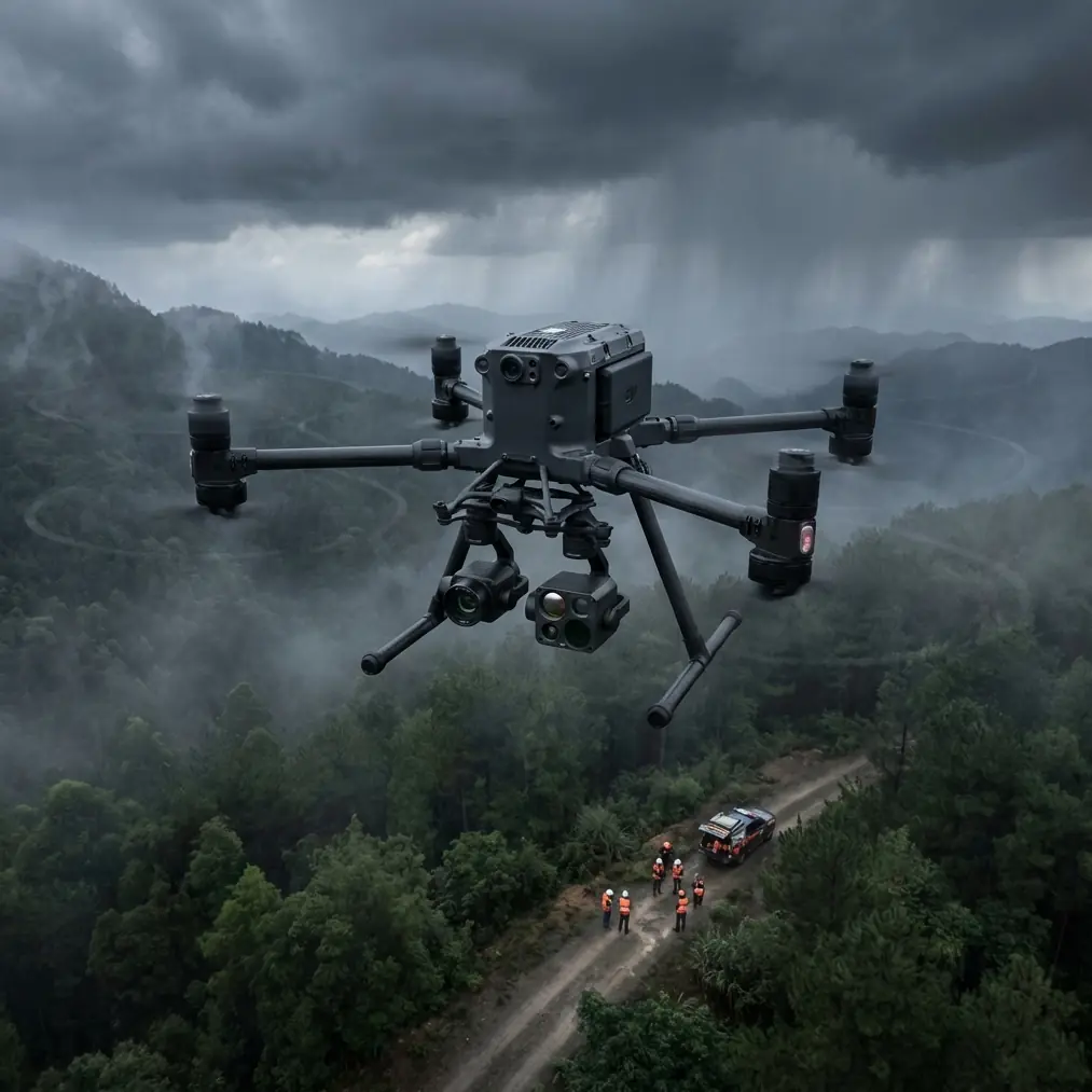
Matrice 400 for Urban Wildlife Mapping: What Its Flight-Control Logic and Structural Margins Mean in the Field
META: A technical review of how Matrice 400 fits urban wildlife mapping, using flight-control and structural reference data to explain stability, payload behavior, thermal work, BVLOS readiness, and mission reliability.
Urban wildlife mapping sounds gentle until you actually plan the mission.
You are often flying in cluttered airspace near buildings, over mixed surfaces that distort heat, around trees that create abrupt wind shear, and across neighborhoods where every interruption matters. You may be collecting photogrammetry in one leg of the mission, thermal signature data in the next, then returning for a battery swap before light changes. A drone in that environment is not judged by brochure language. It is judged by how calmly it holds attitude, how predictably it behaves when the pilot intervenes, and how much structural reserve it keeps when payload and route complexity increase together.
That is why the most useful way to think about the Matrice 400 is not as a generic flagship airframe, but as a platform whose value shows up in control authority, transmission resilience, payload discipline, and repeatable mission geometry.
For wildlife teams working in cities, those details decide whether a survey is merely flyable or genuinely reliable.
Why urban wildlife mapping is harder than ordinary mapping
The city introduces a strange combination of surveying and ecological fieldwork. You may be tracking roosting birds on mid-rise structures at dawn, counting mammals along drainage corridors after sunset, or building a habitat-use model from overlapping thermal and RGB datasets. None of those tasks tolerate sloppy flight behavior.
Photogrammetry wants clean overlap and predictable camera position. Thermal work wants stable motion and repeatable altitude because even slight variation can change how a thermal signature appears against rooftops, pavement, and vegetation. If you are operating under a BVLOS framework or preparing for one, command-link integrity and encrypted data handling stop being nice extras and become core operational requirements.
This is where Matrice 400 stands out against lighter enterprise competitors. Smaller platforms can capture usable imagery, but they tend to reveal their limits sooner when the mission stacks complexity: dual-sensor payloads, denser urban interference, longer corridors, or repeated sorties in the same day. The stronger airframe class matters less for raw speed than for discipline under workload.
The hidden story in the control-system reference data
One of the more revealing reference points comes from the flight-control material in 飞机设计手册 第12册 飞行控制系统和液压系统设计, specifically the control-law table and threshold logic on page 428. The extracted text is fragmented, but a few operationally meaningful details survive clearly.
The first is threshold-based control switching tied to pilot participation and disturbance magnitude. The page references different conditions for “pilot not participating” versus “pilot participating,” and includes deadband-style thresholds such as 0.5 mm and 1.75 mm, along with time constants including T₁ = 0.0338 and T₁ = 0.4 s. Even though this source is an aircraft design handbook rather than a Matrice-specific document, it highlights the kind of control philosophy that serious aircraft use to prevent overreaction to tiny inputs while still responding quickly when the disturbance grows.
For an urban wildlife mission, this matters more than it may seem.
A small deadband or threshold around command inputs helps suppress nuisance corrections. In practice, that translates to less twitchy behavior when the aircraft is holding a hover near a facade, crossing between buildings, or maintaining a precise line for image overlap. If the control system treated every micro-disturbance as a major event, your thermal dataset would suffer from motion inconsistency and your photogrammetry would inherit unnecessary alignment noise. Threshold logic is one of the reasons well-designed aircraft feel “locked in” instead of nervous.
The second useful detail is the presence of mode-dependent gain behavior. The source text shows terms where gains such as Ky are set to zero under certain angle or state conditions, including references around 80–99 and greater than 40°. Again, the OCR is imperfect, but the engineering intent is recognizable: the control system is not using one fixed response everywhere. It changes authority or suppresses certain correction terms when the flight state enters a different regime.
Operationally, that is the difference between a drone that remains predictable across mission phases and one that feels excellent only in calm forward flight. Wildlife mapping in urban settings rarely stays in one regime. You transition from climb-out to corridor tracking, from static hover to oblique inspection angles, from manual intervention back to automated route segments. A platform with mature control-law behavior will handle those transitions without injecting needless oscillation or pilot workload.
When operators say a heavier enterprise drone is “easier to trust,” this is often what they are sensing: not just mass, but controlled management of inputs, gains, and transient response.
Structural margins are not abstract when your payload stack grows
The second reference source, 飞机设计手册 第9册 载荷、强度和刚度, points to dynamic-strength sequence data with numerical values that climb sharply across state sequences. On page 1077, one sequence line progresses from 9.760 to 39.24, while another reaches 70.74, 87.63, 130.4, and even 143.7 depending on the condition grouping.
You do not need the full original table to understand the lesson. Dynamic loads do not increase in a neat linear way as conditions change. They can rise fast as state combinations stack up. That is directly relevant to Matrice 400 missions carrying advanced sensors.
Urban wildlife teams increasingly want one aircraft to do several jobs in a single deployment window: RGB orthomosaic capture, thermal animal detection, perhaps a spotlight or additional positioning accessories for dawn or dusk work, and enough onboard confidence to continue if wind shifts down a street canyon. Every added component changes inertia, structural demand, and how the aircraft sees gusts and control inputs.
The operational significance of those handbook numbers is simple: if dynamic load cases can escalate from around 15.36 to 46.44, or from the teens into triple digits under more severe combinations, then robust platform design is not overengineering. It is what keeps a mission aircraft composed when carrying mixed payloads over repeated sorties.
This is one place where Matrice 400 deserves attention relative to smaller competitors. A lighter platform may look efficient on paper, but once you ask it to carry a serious sensing package and hold geometry in messy urban airflow, the structural and control reserve starts to matter. Reserve is what protects data quality. It is also what protects schedule certainty.
What this means for thermal signature work
Wildlife surveys in cities often fail for a surprisingly mundane reason: the thermal image was technically captured, but not captured consistently enough to support confident interpretation.
Thermal signature work is unforgiving. Rooftops retain heat. Asphalt blooms after sunset. HVAC exhaust creates false positives. Animals can vanish against warm backgrounds if your altitude drifts or your viewing angle changes too much between passes. Stable speed, smooth heading control, and exact line spacing are not luxuries.
A platform like Matrice 400 makes more sense here when paired with strong transmission and onboard processing discipline. O3 transmission is especially relevant in urban mapping because signal quality is not just about range; it is about maintaining clean command and video continuity through interference and reflection-prone environments. If you are flying along a canal lined with concrete walls or near glass-heavy buildings, robust link behavior reduces the chance of disrupted observations right when a target emerges.
AES-256 also matters more than many wildlife teams initially assume. Sensitive ecological data can expose nest sites, den locations, or patterns of protected species use. Encrypted transmission and data handling support ethical fieldwork, especially when coordinating among environmental consultants, municipalities, or conservation groups that cannot risk location leakage.
So when Matrice 400 is discussed in relation to urban wildlife, I would not reduce the conversation to endurance alone. The real advantage is mission integrity: stable flight, stable link, stable data stewardship.
Photogrammetry, GCPs, and the value of repeatability
Urban wildlife mapping is often not just about finding animals. It is about creating explainable habitat maps that can be defended in reports, permit submissions, or ecological impact studies. That means photogrammetry still plays a central role.
You may be producing orthomosaics of green roofs, drainage channels, rail corridors, or fragmented pocket habitats where species movement is constrained by infrastructure. In those situations, GCP strategy still matters, even with a highly capable aircraft. Good ground control points anchor your model to the site. But aircraft stability determines whether you get to use those points efficiently or spend hours correcting weak geometry.
This is another area where the control-system logic from the reference data becomes meaningful in practice. The presence of thresholding and state-dependent gains suggests an approach built to avoid unnecessary control chatter while preserving authority when conditions demand it. For photogrammetry, that tends to show up as more consistent overlap, cleaner tie-point generation, and fewer odd warps in edge zones where buildings, trees, and open corridors meet.
The better the repeatability, the easier it becomes to compare seasonal datasets. For urban wildlife, that is huge. You can revisit the same transect after vegetation changes, construction shifts, or migratory movement and trust that your drone is not adding avoidable variability.
Hot-swap batteries change the survey workflow, not just endurance
Hot-swap batteries are one of those features that seem administrative until you use them on a narrow survey window.
Wildlife teams often work when animals are active, which means dawn, dusk, or short nocturnal intervals. Lose eight or ten minutes to a full power cycle and setup reset, and the site may no longer present the same behavior. Hot-swap capability helps preserve mission rhythm. You land, change packs, and get back in the air while environmental conditions remain comparable.
With Matrice 400, this has a second-order benefit for urban mapping. It allows you to split a larger route into cleaner, controlled segments without treating each battery event as a disruptive restart. That supports better data hygiene for both photogrammetry and thermal capture. It also lowers the temptation to overextend a sortie simply to avoid interruption.
A disciplined operator will always prefer a platform that makes good procedure easier.
BVLOS readiness is really about predictability
BVLOS is often discussed in regulatory language, but from an operator’s point of view it is mostly about trust in systems. Can the aircraft maintain route fidelity? Can the link remain robust in a complex environment? Can the data path be secured? Can transitions between autonomous and pilot-in-the-loop behavior remain smooth?
The reference control material’s distinction between pilot-involved and pilot-not-involved control states is especially relevant here. It reflects a core truth of advanced operations: the aircraft should not behave like two different machines depending on who currently has active input. The handoff should feel coherent.
That coherence is essential for urban wildlife work where you may let the aircraft run a programmed transect, then intervene briefly to verify a thermal anomaly, then resume the route. A stable platform class like Matrice 400 is simply better aligned with that style of operation than smaller systems that begin to feel stretched as mission complexity rises.
If your team is designing workflows around corridor surveys, habitat fragmentation studies, or repeat thermal transects in dense urban areas, it is worth talking through payload matching and mission architecture with a specialist before choosing the final setup. If that would help, you can message a UAV workflow specialist here.
Where Matrice 400 genuinely excels
The strongest case for Matrice 400 in urban wildlife mapping is not a single specification. It is the way several mission-critical traits reinforce each other.
A mature control philosophy reduces unnecessary corrections and preserves stability when flight conditions change. The reference thresholds of 0.5 mm and 1.75 mm, along with fast and slower response constants like 0.0338 and 0.4 s, illustrate why well-designed aircraft avoid both overreaction and sluggishness. Dynamic-strength values in the structural reference rising from 9.760 to 39.24, or up to 143.7 in more severe sequences, remind us that payload and maneuver complexity can drive load demands far higher than casual users assume. Those are not trivia points. They explain why larger enterprise aircraft maintain composure when the job gets real.
Add O3 transmission, AES-256 security, hot-swap batteries, and a payload ecosystem suited to thermal and photogrammetry work, and the platform starts to make sense as a professional ecological tool rather than just a general-purpose drone.
Compared with lighter competitors, Matrice 400 is better positioned for the operator who values consistency over minimalism. In urban wildlife mapping, consistency is everything. It protects the route. It protects the image stack. It protects the interpretation.
And in the end, it protects the credibility of the survey itself.
Ready for your own Matrice 400? Contact our team for expert consultation.