Matrice 400 in Low-Light Coastline Work: A Field Report
Matrice 400 in Low-Light Coastline Work: A Field Report on What Actually Matters
META: Expert field report on using Matrice 400 for low-light coastline monitoring, with practical insight on thermal detection, EMI management, ground testing logic, data capture workflow, and operational safety.
I’ve spent enough time around industrial UAV programs to know that low-light coastline work is rarely limited by the drone’s brochure specs. The real bottleneck is whether the aircraft, payload, data chain, and crew can keep producing trustworthy information after sunset, with salt air, variable wind, reflective water, and intermittent electromagnetic interference all working against you.
That is where the Matrice 400 becomes interesting.
Not because it is simply “powerful,” but because the mission profile itself demands a disciplined system view. A coastal operator flying in low light is not just trying to keep an aircraft in the air. They are trying to detect weak thermal signature differences, maintain stable transmission across cluttered RF conditions, preserve image integrity for later photogrammetry, and avoid the kind of small systems failure that turns a routine monitoring sortie into a lost data set.
For this kind of work, I don’t think the best way to discuss Matrice 400 is as a generic enterprise drone. It makes more sense as a platform inside a testable, measurable workflow.
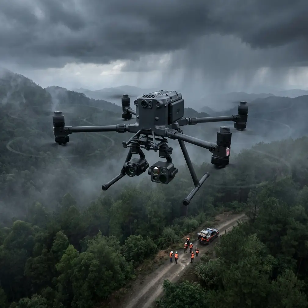
The coastline changes the rules
Low-light coastal monitoring sounds straightforward until you are standing on a seawall at dawn with spray in the air and a thin fog band over the water. Surface contrast drops. Visual references degrade. Reflections distort perception. The mission often involves long linear assets or wide littoral areas, which pushes transmission reliability and energy planning harder than many inland inspection jobs.
A Matrice 400 assigned to this environment is usually supporting one of several civilian tasks:
- shoreline erosion observation
- habitat monitoring
- port and jetty condition checks
- marine debris detection
- drainage outfall assessment
- nighttime or dawn infrastructure inspection near coastal facilities
Each of those tasks benefits from different sensors, but they all share one core requirement: the operator needs dependable data under conditions that are less forgiving than daylight over flat farmland.
That is why low-light work is not only about camera sensitivity. It is about the entire support architecture behind the aircraft.
Why old aircraft design logic still applies to a modern UAV mission
One of the more useful reference points here comes from traditional aircraft fuel-system design, which emphasizes something deceptively simple: hazardous fluids and vapors must be kept away from hot zones, ignition sources, and recirculation paths. The source material states that vent outlet location and structure must prevent fire, icing, and lightning strike problems, while also ensuring spilled fuel or vapor does not blow back into the aircraft or reach the exhaust system. It also requires that accumulated water in the line be able to drain out of the aircraft.
That principle matters to a Matrice 400 operator even though the aircraft itself is not a fuel-burning platform.
Why? Because the coastal drone environment creates similar systems-thinking problems in different forms. Moisture intrusion, salt contamination, temperature gradients, and airflow recirculation all influence reliability. If you are working near lights, coastal facilities, or communication towers, you also need to think in terms of where environmental stress enters the system and how it exits. Water pooling in connectors, condensate around sensors, and salt on vented or exposed components are not glamorous topics, but they decide whether your thermal payload delivers a clean image or an intermittent fault.
Another aircraft-design detail from the reference is even more useful operationally: system temperature must stay below the fuel’s minimum autoignition temperature with a safety margin generally given as 30 K. For drone crews, the direct lesson is not about fuel chemistry. It is about margin discipline. In low-light coastal work, where batteries, processors, radios, and payloads may all run for extended periods, heat margin is not theoretical. A mission can look stable from the pilot’s perspective while internal temperatures are drifting toward degraded performance.
On a Matrice 400 sortie, this translates into a practical checklist mindset:
- don’t evaluate thermal performance only at takeoff
- watch how onboard processing and transmission loads affect endurance
- expect salt-laden air and still conditions to reduce your cooling comfort zone
- build a reserve instead of planning against ideal figures
Operators who understand margin tend to produce more consistent results than operators who simply trust nominal runtime.
Low light means the sensor stack has to be treated as a measurement system
The second reference document deals with ground test equipment, and although it comes from a broader aerospace context, it maps almost perfectly onto serious Matrice 400 operations. It breaks a data acquisition system into three core parts: input, signal conversion and data processing, and output. It also notes that the main purpose of such systems is to measure, collect parameters, process them as required, and then display, record, and store the results.
That is exactly how a coastline monitoring team should think.
The drone is not the whole system. It is only one part of a measurement chain.
1. Input: what are you actually sensing?
In low light, the input side often includes more than one data source. Thermal signature collection may help identify water seepage, wildlife presence, warm machinery, or human activity near infrastructure without relying on visible-light contrast. A visual payload still matters for contextual interpretation and follow-up photogrammetry. If the mission includes shoreline change analysis, GCP-backed mapping runs may be needed during better light windows to tie the low-light observations into a larger survey record.
The point is not to gather everything. The point is to define which physical quantity matters.
Temperature difference? Surface geometry? Moisture behavior? Structural deformation? Debris accumulation?
When the objective is vague, even a high-end platform underperforms.
2. Signal conversion and processing: the quiet failure point
The reference material specifically calls out signal transmission, A/D conversion, and the use of processors in the data chain. On a Matrice 400 mission, this is where many operators lose rigor. They obsess over flight control and forget that degraded or unstable signal handling can quietly corrupt the mission outcome long before the aircraft lands.
If you are using O3 transmission in a cluttered coastal zone, especially near port infrastructure, telecom masts, utility corridors, or large metal structures, electromagnetic interference can become the hidden constraint. In the field, one of the simplest corrective actions is often antenna adjustment rather than immediate relocation.
I’ve seen crews improve link quality just by changing ground antenna orientation, raising the controller position slightly above a seawall, and moving laterally to clear reflections from metal railings. That sounds basic because it is basic. But it matters. RF cleanliness is rarely won by theory alone; it is usually won by small physical changes in the setup.
In practical terms, when the Matrice 400 begins showing unstable downlink behavior during a low-light shoreline run, I look at these factors before blaming the platform:
- antenna angle and polarization relative to the aircraft path
- controller position versus metal clutter
- direct line of sight over wave breaks, boats, and railings
- nearby emitters from port or utility infrastructure
- whether the flight path is forcing the link through a reflective corridor
This becomes even more critical for BVLOS-style planning frameworks, even where actual operations remain subject to local rules and approvals. Once the aircraft is serving a long linear corridor, transmission integrity stops being a convenience and becomes part of mission validity.
3. Output: can the result be used later?
The reference reminds us that output is not just display. It includes recording and storage. That should sound obvious, yet a surprising number of drone teams still treat the live feed as the mission itself.
For coastline monitoring, the output stage must support later review. That means clean file management, synchronized metadata, time alignment, and secure handling where appropriate. If the work touches sensitive infrastructure or client-controlled assets, encrypted workflows such as AES-256-secured data handling may become part of the operational baseline rather than an optional extra.
A low-light detection that cannot be traced, timestamped, and compared against prior runs has limited value. The Matrice 400 can gather excellent information, but only if the output side of the workflow is designed to preserve it.
Why trial structure matters more than marketing language
The second document also includes a striking production-control detail: at least three first-batch prototypes are required, and one is selected for stiffness, strength, platform settlement, and airtightness tests before production proceeds. That number — three — is not trivia. It reflects a mindset that mature aerospace teams use instinctively: do not trust a system because one unit seems fine on one good day.
For Matrice 400 operators, especially those building repeatable coastal monitoring programs, this has direct relevance.
Before standardizing a low-light mission profile, treat your setup like a pre-production test article. Run repeated trials with the same route, payload configuration, and reporting objective. Then vary one factor at a time:
- wind direction
- humidity level
- battery change timing with hot-swap batteries
- antenna placement
- thermal palette settings
- altitude and shoreline offset
- visible/thermal handoff timing
This produces real operational confidence. One successful mission proves almost nothing. Three structured repetitions tell you where the edge of the envelope really is.
The battery strategy is not just about endurance
Hot-swap batteries are often discussed as a convenience feature. In coastline monitoring, they are more than that. They preserve sortie rhythm.
When you are trying to document transient low-light conditions — first light, tidal transitions, cooling infrastructure, temperature inversions over wet ground — losing excessive time on the ground can erase the environmental pattern you were trying to measure. Hot-swap capability helps maintain continuity in observation windows, especially when the crew is working from an exposed shoreline access point with limited setup space.
That continuity is operationally significant. It makes comparative thermal work more reliable. It also reduces pressure on the crew to overextend a single flight to “finish the line,” which is where rushed decisions start to appear.
Thermal is powerful, but context wins the mission
The reader scenario here is low-light coastline monitoring, so thermal signature deserves special attention. Thermal data can reveal patterns the eye will miss. But coastline environments are full of false confidence traps. Wet rock, concrete retaining walls, exposed pipes, pooled water, and residual heat from equipment can all create signatures that appear significant until they are cross-checked against visible imagery, prior survey baselines, or site knowledge.
That is why I like pairing thermal collection with a photogrammetry mindset, even when the mission is not a full mapping job. If the Matrice 400 is used to identify anomalies in low light, the follow-up workflow should be designed so those observations can be spatially anchored and compared. If higher-accuracy measurement is needed later, GCP-supported capture becomes the bridge from “interesting detection” to “actionable record.”
In other words, thermal finds. Spatial workflow proves.
The human factor is still the deciding factor
No aircraft can fix a poorly organized field process. A solid Matrice 400 coastal team usually looks boring in the best possible way. Their preflight is structured. Their controller and antenna placement are deliberate. Their payload settings are chosen before launch, not improvised halfway through the run. Their data folders make sense. Their crew knows what constitutes an acceptable thermal anomaly and what needs another pass.
And when the environment starts to interfere, they adjust physically first. Change stance. Change antenna orientation. Step away from conductive clutter. Re-check line of sight. Confirm whether the issue is actual link degradation or just a display artifact. That discipline is what keeps a mission from unraveling.
If you are building or refining this type of operation and want a practical conversation about payload pairing, transmission planning, or coastal low-light workflow design, you can message our field team directly.
What makes the Matrice 400 the right fit here
For coastline monitoring in low light, the Matrice 400 is best understood as an operational platform that can support a layered sensing and data process, not as a standalone flying camera. Its value comes from how well it integrates with disciplined testing, robust transmission planning, thermal interpretation, and repeatable output handling.
The aerospace references behind this discussion may seem distant from a commercial UAV job, but the core lessons are highly relevant. Design for safe margins. Control where environmental hazards interact with the system. Treat sensing as a full chain from input to output. Validate with repeated trials, not isolated success. Those principles are older than enterprise drones, and they still separate dependable programs from fragile ones.
On a darkened coastline, that difference becomes obvious fast.
Ready for your own Matrice 400? Contact our team for expert consultation.