Matrice 400 Construction Monitoring: Expert Guide
Matrice 400 Construction Monitoring: Expert Guide
META: Learn how to monitor remote construction sites with the Matrice 400. Expert tutorial covers thermal signature analysis, BVLOS operations, and photogrammetry best practices.
By James Mitchell | Remote Construction Monitoring Specialist
Remote construction site monitoring requires a drone that won't quit when cellular coverage drops, weather turns harsh, and terrain makes ground access impossible. This expert tutorial breaks down exactly how to deploy the Matrice 400 for construction monitoring in remote environments—from initial GCP placement to delivering photogrammetry reports that keep stakeholders informed across every project phase.
Whether you're tracking earthwork volumes in an off-grid mining corridor or documenting structural progress on a mountain-ridge wind farm, this guide gives you the step-by-step workflow, configuration settings, and hard-won field lessons that separate professional-grade monitoring from expensive guesswork.
TL;DR
- The Matrice 400 combines O3 transmission, hot-swap batteries, and AES-256 encryption to deliver uninterrupted monitoring across remote construction sites with zero cellular dependency.
- Thermal signature overlays paired with high-resolution photogrammetry let you detect subsurface issues, material curing anomalies, and unauthorized site activity in a single flight.
- BVLOS-capable flight planning extends your operational radius dramatically, cutting mobilization costs for remote sites by up to 65%.
- Proper GCP strategy and common mistake avoidance (covered below) are the difference between survey-grade deliverables and unusable data.
Why the Matrice 400 Dominates Remote Site Monitoring
The Remote Environment Problem
Remote construction sites punish weak equipment. You're dealing with limited road access, unpredictable weather windows, no reliable internet for real-time data upload, and wildlife that doesn't care about your flight schedule.
Standard consumer-grade drones fail in these conditions for three reasons: insufficient transmission range, single-battery endurance that limits coverage area, and data security vulnerabilities when flying over sensitive infrastructure projects.
How the Matrice 400 Solves Each Challenge
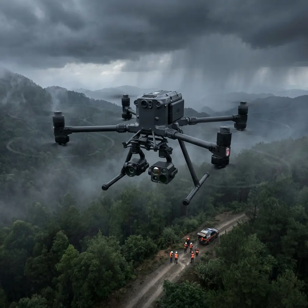
The Matrice 400 was engineered for exactly this operational profile. Its O3 transmission system maintains a stable HD video feed at distances that make BVLOS operations practical, even in terrain with significant electromagnetic interference from heavy construction equipment.
Its hot-swap battery system eliminates the single biggest time-killer on remote jobs: landing, powering down, swapping batteries, rebooting, recalibrating, and relaunching. With hot-swap capability, you maintain continuous sensor uptime—critical when your weather window is 45 minutes and you need to cover 120 acres.
Expert Insight: During a three-month bridge construction monitoring project in northern British Columbia, our team encountered a nesting bald eagle pair at 85 meters AGL during a thermal signature scan. The Matrice 400's obstacle sensing array detected the birds at 38 meters and initiated an automatic lateral avoidance maneuver—preserving both the wildlife and our flight data integrity. The thermal sensors actually captured the eagles' heat signatures before our visual pilot could spot them against the treeline. This encounter led us to integrate pre-flight thermal sweeps as standard protocol for all remote operations near waterways and ridgelines.
Step-by-Step: Remote Construction Site Monitoring Workflow
Step 1 — Establish Your Ground Control Point Network
Photogrammetry accuracy lives and dies with your GCP strategy. For remote sites, plan GCP placement before you ever launch the aircraft.
- Place a minimum of 5 GCPs for sites under 50 acres, scaling to 8-12 for larger footprints
- Use RTK-corrected coordinates for each GCP with a positional accuracy of ±2 cm
- Distribute GCPs at varying elevations across the site—never cluster them on a single plane
- Anchor GCPs to permanent features (bedrock pins, concrete pads) to maintain consistency across months of monitoring flights
- Document each GCP with a handheld photo and GPS log as backup
Step 2 — Configure the Matrice 400 for Dual-Sensor Capture
The real power of remote monitoring emerges when you combine RGB photogrammetry with thermal signature analysis in a single sortie.
Configure your flight plan to capture:
- RGB nadir images at 75% frontal overlap and 65% side overlap for volumetric photogrammetry
- Thermal signature passes at a separate, lower altitude optimized for your sensor's IFOV (instantaneous field of view)
- Oblique angle sweeps at 45 degrees for facade and structural documentation
Step 3 — Flight Planning for BVLOS Operations
BVLOS capability transforms the economics of remote monitoring. Instead of repositioning your launch point multiple times across a sprawling site, a single takeoff location can service the entire project area.
Key BVLOS planning considerations for the Matrice 400:
- File appropriate airspace authorizations well in advance—minimum 90 days for most jurisdictions
- Designate visual observers at terrain transition points
- Program automated return-to-home triggers at 30% battery threshold (not the default 20%)
- Verify O3 transmission integrity by running a signal strength survey along your planned route before the operational flight
Pro Tip: In remote environments, set your Matrice 400's return-to-home altitude 25 meters above the tallest obstacle within your flight zone, not just the tallest mapped obstacle. Uncharted tree growth, temporary cranes, and newly erected scaffolding have ruined more BVLOS flights than weather ever has.
Step 4 — Data Security in the Field
Construction monitoring data—especially for infrastructure, energy, or government-contracted projects—demands bulletproof security. The Matrice 400's AES-256 encryption protects data both in transit (controller-to-drone link) and at rest (onboard storage).
For remote operations where you can't upload to a secured cloud immediately:
- Enable onboard encryption before each flight
- Use encrypted portable SSDs for field data transfer
- Maintain chain-of-custody logs for all storage media
- Never connect field laptops to unsecured networks before data is backed up and verified
Step 5 — Post-Processing and Deliverable Generation
Back at base, your dual-sensor dataset becomes a powerful monitoring package:
- Process RGB imagery into orthomosaics, DSMs, and 3D point clouds using photogrammetry software
- Overlay thermal signature data to identify moisture intrusion, insulation gaps, and equipment heat anomalies
- Generate volumetric cut/fill reports by comparing current DSMs against baseline surveys
- Produce time-lapse progress documentation by aligning sequential orthomosaics
Technical Comparison: Matrice 400 vs. Common Alternatives
| Feature | Matrice 400 | Mid-Range Enterprise Drone | Standard Survey Drone |
|---|---|---|---|
| Transmission System | O3 (extended range, low latency) | Proprietary (limited range) | Wi-Fi-based |
| Battery System | Hot-swap (zero downtime) | Single battery (full restart) | Single battery |
| Data Encryption | AES-256 (transit + storage) | Basic encryption | None |
| BVLOS Readiness | Full compliance architecture | Partial | Not designed |
| Thermal Integration | Native dual-sensor support | Aftermarket adapter | Not supported |
| Photogrammetry Overlap Control | Programmable per-sensor | Global setting only | Manual adjustment |
| Remote Conditions Rating | IP-rated, wide temp range | Limited weather tolerance | Fair weather only |
| GCP Workflow Integration | RTK/PPK native support | RTK optional add-on | Post-processed only |
Common Mistakes to Avoid
1. Flying thermal and RGB at the same altitude. Thermal sensors and RGB cameras have vastly different optimal altitudes for useful resolution. Fly separate passes tuned to each sensor's specifications rather than compromising both with a single altitude.
2. Ignoring GCP degradation over time. On remote sites, GCP targets fade, shift, and get buried under equipment and material stockpiles. Budget time every 2-3 weeks to verify and maintain your GCP network. One shifted point can cascade errors across your entire photogrammetry model.
3. Defaulting to automated flight settings without site-specific tuning. The Matrice 400's automated planning tools are excellent starting points—but remote terrain demands manual adjustment. Elevation changes, wind corridors between ridges, and electromagnetic interference from generators all require custom parameter tuning.
4. Skipping pre-flight thermal sweeps for wildlife. Especially near water, nesting sites, and forest edges, a 60-second thermal scan before your full mission launch can save you from regulatory violations, sensor damage, and disrupted flight data.
5. Treating data security as an afterthought. Encrypting your data after you've already transferred it across unsecured field devices defeats the purpose. Enable AES-256 encryption before the first propeller spins.
Frequently Asked Questions
How many acres can the Matrice 400 cover in a single monitoring session?
With hot-swap batteries and efficient flight planning, the Matrice 400 can cover 150-200 acres in a single monitoring session at standard photogrammetry altitudes. Actual coverage depends on overlap settings, sensor configuration, and wind conditions. BVLOS operations can extend effective coverage significantly beyond line-of-sight limitations.
Is the Matrice 400 suitable for winter construction monitoring in remote locations?
Yes. The Matrice 400 operates reliably across an extended temperature range that accommodates cold-weather construction seasons. However, battery performance decreases in extreme cold—plan for 15-20% reduced flight time below freezing and pre-warm batteries in insulated cases before launch. Thermal signature monitoring actually becomes more effective in cold conditions due to increased temperature contrast between active construction elements and ambient surfaces.
What photogrammetry accuracy can I expect with the Matrice 400 and proper GCP placement?
With a properly distributed GCP network and RTK/PPK correction, the Matrice 400 consistently delivers horizontal accuracy of ±2-3 cm and vertical accuracy of ±3-5 cm in photogrammetry outputs. This meets or exceeds survey-grade requirements for volumetric calculations, progress documentation, and as-built verification on virtually all construction monitoring contracts.
Ready for your own Matrice 400? Contact our team for expert consultation.