Matrice 400 for Construction Sites in Complex Terrain
Matrice 400 for Construction Sites in Complex Terrain: An Expert How-To
META: Learn how to use Matrice 400 for construction site monitoring in complex terrain, with expert guidance on weather resilience, thermal workflows, photogrammetry accuracy, transmission stability, and mission planning.
Construction sites in broken terrain expose every weakness in an aerial workflow.
Steep cut slopes, temporary haul roads, blind spots behind spoil piles, changing elevations, gusts rolling off ridgelines, and crews working across a wide footprint all create the same operational problem: you need reliable data without constantly re-flying the mission. That is where the Matrice 400 deserves a serious look—not as a generic “enterprise drone,” but as a platform that can keep a survey, inspection, and progress-monitoring program stable when the site itself refuses to stay simple.
I’ve spent enough time around heavy civil and infrastructure projects to know that drone performance on paper means very little unless it translates into repeatable outputs. On a construction site, repeatability matters more than headline specs. You need the aircraft to hold its mission geometry, preserve link quality, protect the integrity of onboard systems, and continue delivering usable imagery even when weather and terrain start piling on complications.
This is the practical framework I would use for deploying a Matrice 400 on a complex construction site.
Start with the site’s real problem, not the aircraft
Most construction teams say they want “better drone coverage.” That’s vague. The real needs are usually much more concrete:
- weekly earthwork volume tracking
- orthomosaics for planning and claims support
- thermal signature checks on electrical runs, drainage anomalies, or material stockpiles
- corridor progress records along access roads or utilities
- visual inspection of retaining structures, cut faces, and temporary works
- safer oversight of hard-to-reach zones without sending personnel into unstable areas
In complex terrain, one flight rarely solves all of that. The smarter play is to split operations into mission types.
A Matrice 400 workflow should usually be divided into three buckets:
- Photogrammetry missions for mapping and measurable site records
- Thermal and visual inspection passes for anomaly detection
- Rapid-response flights when weather, slope movement, drainage issues, or schedule disputes require same-day evidence
That separation matters because each mission type stresses the aircraft differently. Mapping needs consistency. Inspection needs angle flexibility. Rapid response needs confidence that the drone can go up quickly and stay dependable when conditions aren’t ideal.
Why structural design details matter on a muddy jobsite
Construction environments are brutal on airframes. Dust, moisture, vibration, repeated transport, and frequent payload changes wear systems down fast. This is why a seemingly obscure aircraft design principle from traditional aerospace engineering becomes very relevant here: sealing.
One of the source references highlights removable skin sealing structure design on page 620, along with broader system installation sealing design on page 621 and flange-to-structure sealing design on page 622. Another section covers environmental effects and protection on page 680, including humidity and heat and corrosion protection on page 682.
Those are not academic details. On a site where the Matrice 400 is launched from damp ground at sunrise, then flown through fine dust after noon traffic picks up, sealing and environmental protection directly affect operational uptime. If an aircraft is expected to support repeated construction monitoring, its structural approach to sealing around access points, installed systems, and exposed interfaces becomes part of its field reliability story.
Operationally, this means three things for a Matrice 400 user:
- Fewer interruptions from environmental contamination when working around wet aggregate, dust, and airborne grit
- More confidence during payload swaps and transport cycles, where removable panels and interfaces are repeatedly handled
- Better resilience across seasonal work, especially in humid valleys, coastal projects, or sites with sharp day-night temperature swings
A lot of drone buyers focus only on camera capability. On construction projects, I look just as hard at whether the platform appears designed to survive repeated real-world exposure. Sealing design and environmental protection are not glamour topics, but they decide whether your flight program becomes dependable or annoying.
Mission planning for elevation changes and blocked sightlines
Complex terrain punishes lazy planning.
If your site includes benches, ridges, excavation pits, or winding haul routes, a flat-altitude mission plan can wreck overlap consistency and distort your outputs. With the Matrice 400, I would build missions around terrain logic, not just boundary logic.
For photogrammetry:
- Use terrain-aware mission planning where available
- Confirm overlap targets account for vertical relief, not just horizontal coverage
- Place GCPs where they remain visible across changing slope angles
- Avoid clustering all control points on accessible flat areas near the site office
- Add check points at different elevations to catch vertical bias in processing
GCP placement is where many construction teams still lose accuracy. On a complex site, photogrammetry is only as defensible as the distribution of your control. If all your GCPs sit in one elevation band, the final surface model can look clean while hiding measurable error on the upper cuts or lower drainage areas.
That matters when you are comparing week-over-week progress or calculating quantities tied to contractor payment.
The Matrice 400 earns its keep when it supports enough mission stability to make these repeat surveys consistent. The aircraft is only one piece of the chain, but it is the piece you are trusting to hold course, maintain image capture discipline, and preserve a clean link over a messy site.
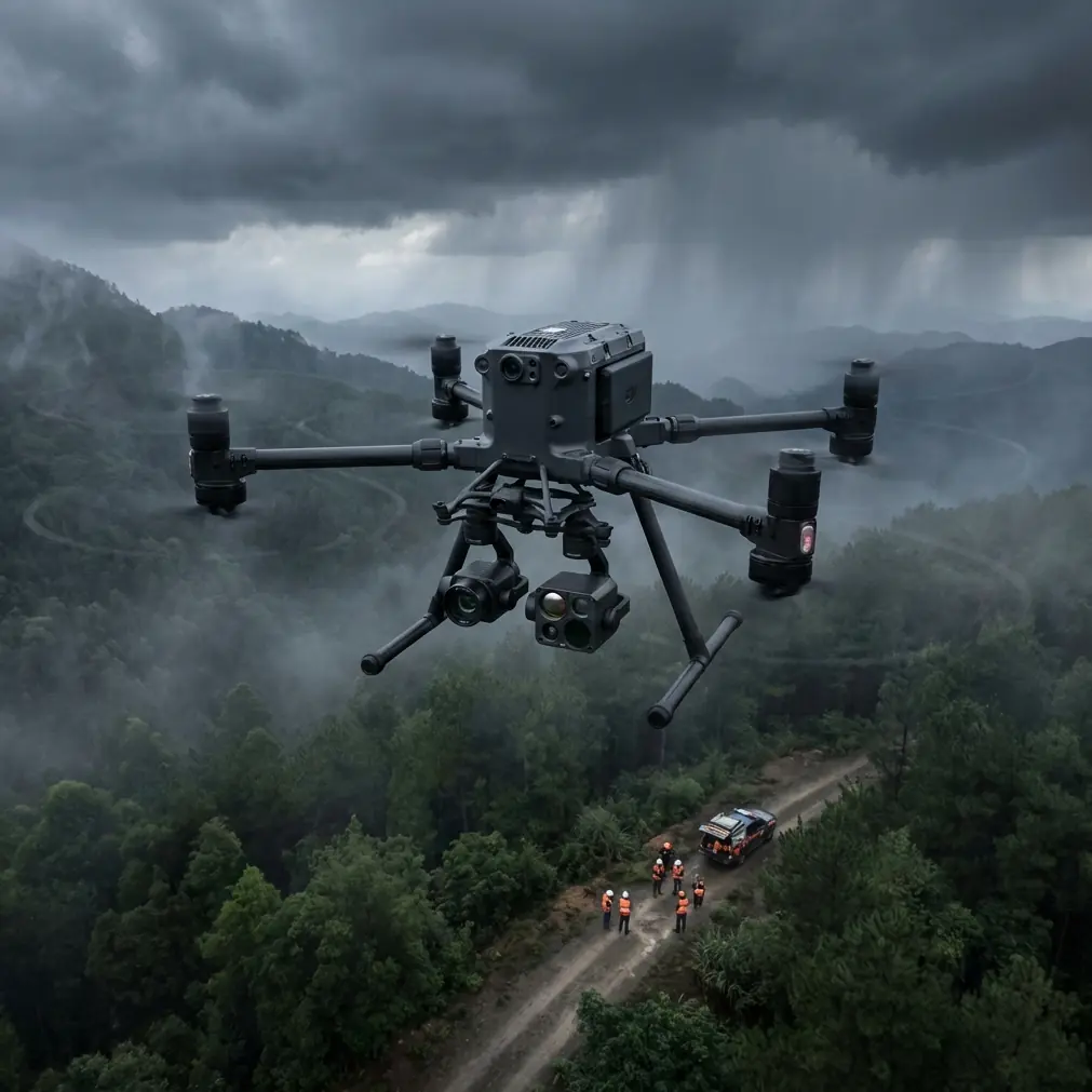
What happened when weather changed mid-flight
One of the best tests of any construction drone is what it does when the forecast was technically right but operationally useless.
On one type of terrain-heavy job, conditions can begin calm at takeoff and turn awkward halfway through the mission. Sun heats a slope, air starts moving differently through the cut, and suddenly the aircraft is dealing with lateral gusts near an exposed ridge while shadows deepen over the lower work zone.
That is the moment when site teams stop caring about brochure language.
With the Matrice 400, the priority in that kind of mid-flight weather shift is not heroics. It is maintaining data quality while preserving a safe, orderly mission outcome. If the aircraft can hold link stability through O3 transmission, maintain clear telemetry awareness, and allow the pilot to make an informed go/no-go decision without losing confidence in the platform, it has already done something valuable.
On construction sites with partial line-of-sight blockage from terrain or structures, transmission quality is more than convenience. It influences whether you can finish a slope inspection pass cleanly or whether you end up with fragmented datasets and wasted battery cycles. Add AES-256 into the picture and the workflow also becomes easier to justify where project data sensitivity matters—especially on infrastructure, energy, or private industrial sites where aerial records should not be treated casually.
In practical terms, when weather changed mid-flight, what mattered was this:
- the link stayed stable enough to assess the situation properly
- the aircraft did not force a rushed decision through degraded situational awareness
- the crew could either complete the critical segment or recover and relaunch with minimal confusion
- the data already collected remained usable rather than compromised by interrupted execution
That is what professionals mean when they talk about resilience. Not “flying in anything,” but preserving mission discipline when conditions become less cooperative.
Use thermal intelligently, not as a novelty layer
The Matrice 400 becomes much more useful on construction projects when thermal is treated as a decision tool rather than a flashy add-on.
A thermal signature can help detect:
- standing water hidden beneath surface disruption
- heat irregularities in temporary power components
- drainage failures after rain
- moisture intrusion patterns in certain built elements
- hotspots in equipment staging areas or material storage concerns
On complex terrain, thermal can also help prioritize where the visual team should spend time on foot. That is a major efficiency gain. Instead of walking every drainage swale or checking every exposed section manually, the drone can narrow the search area.
The key is timing. Thermal flights should be planned around the thermal behavior of the site, not whenever the crew has a spare window. Early morning and late afternoon often produce more interpretable contrast than midday, depending on the material and the inspection objective.
If the Matrice 400 is part of a recurring site-monitoring program, pair thermal passes with standard visual records on the same route. That creates a stronger historical baseline and makes anomaly detection much more credible over time.
Hot-swap batteries change the rhythm of site operations
Battery handling rarely gets enough attention in construction drone planning.
When crews are under schedule pressure, every interruption increases the temptation to cut corners—skip a control check, rush a relaunch, or compress a mission. That is why hot-swap batteries matter more on a construction site than they do in a simple demo environment.
The value is not just faster turnaround. It is continuity.
On large or segmented sites, battery swaps often happen between mapping blocks, inspection sectors, or follow-up passes requested by the superintendent after seeing the first dataset. A hot-swap workflow helps preserve operational momentum while reducing the awkward dead time that causes teams to postpone needed flights until “later,” which usually means never.
That becomes especially useful in mixed missions. You might finish a photogrammetry block, then immediately launch a targeted thermal pass over a drainage issue reported from the lower access road. When site conditions are changing by the hour, fast restart capability is not a luxury. It protects the relevance of your data.
Don’t ignore control-system logic behind the scenes
One of the source references from the aircraft design handbook touches on major performance requirements for large civil aircraft flight control systems on page 521, with associated certification and design analysis nearby. It also references system integration testing around page 457 and hydraulic system design fundamentals later in the section.
Why should a Matrice 400 operator care about that?
Because commercial drone reliability is not only about airframe toughness. It is also about how the flight-control architecture behaves under real task loading. Construction site missions demand frequent speed changes, altitude adjustments, hover precision near structures, and repeated transitions between wide-area coverage and close inspection. A platform influenced by mature flight-control thinking tends to feel steadier in these mixed operational modes.
The same source also includes O-ring compression and fill-rate calculations around page 528 and maximum/minimum compression-rate checks on page 532. Again, that sounds deeply technical—and it is—but the field relevance is simple: hydraulic and sealing design discipline reflects the broader engineering mindset behind dependable mechanical systems. In harsh environments, details like seal compression tolerance affect whether components continue performing across pressure variation, temperature shifts, and repetitive use.
For the construction operator, the takeaway is straightforward. A serious aircraft should not merely carry sensors. It should embody the kind of design attention that supports repeated field deployment without becoming maintenance drama.
Building a repeatable Matrice 400 workflow for construction teams
If I were setting up a Matrice 400 program for a site with steep grades and dispersed activity zones, I would standardize operations around this sequence:
1. Define the deliverable before the flight
Decide whether the mission is for quantities, progress reporting, thermal anomaly detection, or executive visuals. Do not combine objectives carelessly.
2. Segment the site by terrain behavior
Separate ridgeline work, excavation bowls, access corridors, and staging yards into their own flight logic.
3. Use GCPs with elevation discipline
Distribute GCPs across upper, middle, and lower terrain bands. Validate with independent checkpoints.
4. Reserve one weather buffer window
Expect conditions to shift. On exposed sites, they usually do.
5. Use visual and thermal as complementary layers
Let photogrammetry create the measurable record. Let thermal guide attention to exceptions.
6. Protect data continuity
Stable O3 transmission and encrypted AES-256 workflows matter when flights cover sensitive infrastructure or long site spans.
7. Keep battery transitions fast and organized
Hot-swap batteries help maintain tempo, especially when supervisors ask for follow-up views before crews move equipment.
8. Plan for future scalability
If the project may move toward longer route inspections, remote oversight, or controlled BVLOS operations where regulations and approvals allow, structure your data and mission protocols now rather than rebuilding later.
A note for project teams who need less friction
The most successful drone programs on construction sites are rarely the most complicated. They are the ones that fit into the site’s daily cadence without creating extra administrative drag for surveyors, superintendents, and project managers.
If your team is trying to determine whether the Matrice 400 is the right fit for steep, fragmented, or weather-sensitive construction work, it helps to talk through payload choice, control strategy, and deliverable design before the first deployment. For a direct technical discussion, you can message a Matrice 400 workflow specialist here.
What makes the Matrice 400 genuinely useful here
For construction monitoring in complex terrain, the Matrice 400 stands out when you view it as an operational system rather than just an aircraft body with a camera attached.
Its value shows up in the moments that affect project decisions:
- when a mapping mission has to remain consistent across broken elevation
- when thermal findings need to be tied back to visible site conditions
- when mid-flight weather shifts test link confidence and crew judgment
- when repeated transport, dust, moisture, and handling put structural sealing and environmental protection to work
- when battery swaps and relaunch speed determine whether the data is still timely
- when secure transmission and disciplined mission planning support more sensitive projects
That is the difference between a drone that occasionally produces impressive images and one that becomes part of the construction management process.
Ready for your own Matrice 400? Contact our team for expert consultation.