Matrice 400 in the Mountains: A Field Report
Matrice 400 in the Mountains: A Field Report on Construction Monitoring Where Small Tolerances Matter
META: Expert field report on using Matrice 400 for mountain construction site monitoring, with practical insight on thermal workflows, photogrammetry, EMI handling, transmission reliability, and why aircraft-grade tolerance thinking matters.
Mountain construction work exposes every weakness in an aerial workflow. Wind curls around cut slopes. Signal paths change as machines move and fresh steel goes into the ground. Temperature swings distort materials, batteries, and even expectations. That is exactly why the Matrice 400 deserves to be discussed as a field system, not just a drone platform.
I have been looking at it through the lens that matters on real projects: whether it can produce dependable site intelligence when the operating environment refuses to cooperate.
For a mountain jobsite, that means three things above all else. First, the aircraft has to hold a stable link across broken terrain. Second, payload data has to remain trustworthy enough for progress verification, slope observation, and thermal anomaly checks. Third, the whole workflow has to be repeatable, because one clean mission means very little if the next five are inconsistent.
The Matrice 400 fits that conversation well, especially when you pair its transmission stack, hot-swap battery practicality, and sensor flexibility with disciplined field procedures. But the real story is not simply that it flies. The story is how small engineering tolerances, the kind usually buried in aircraft design manuals, become operationally relevant on a modern mountain construction site.
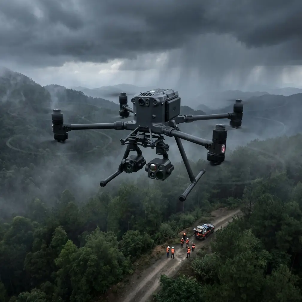
Why mountain sites punish sloppy drone operations
Flatland mapping is forgiving. Mountain construction is not.
On a ridge road or dam access build, line of sight can disappear with one turn of a haul route. Excavators and temporary power infrastructure create localized electromagnetic noise. Fresh retaining structures, rebar cages, and steel site cabins alter reflections and multipath behavior. A drone that looked perfectly configured in the yard can start dropping video quality or showing intermittent control warnings once it is working above active earthworks.
This is where O3-class transmission architecture and disciplined antenna management stop being spec-sheet trivia. In practice, when interference rises, the first correction is not panic. It is geometry. I have had the best results by repositioning the pilot relative to the terrain break, then fine-tuning antenna orientation to preserve the cleanest possible polarization and path back to the aircraft. On mountain sites, even a modest adjustment in stance and antenna angle can noticeably improve link confidence, especially when the aircraft is skimming the far side of a cut or orbiting a structure that is shedding interference.
That matters because construction monitoring is rarely just “go up and look around.” It is repeat capture. The superintendent wants consistent progress imagery. The survey team wants photogrammetry they can align against GCPs. The safety manager may want thermal signature checks on temporary electrical runs, stockpiled material heating, or drainage behavior after rain. Once the link becomes unstable, the quality of every downstream decision drops with it.
The hidden value of aircraft-style tolerance thinking
One of the most useful lessons from classical aircraft design references is that reliability comes from controlling tiny variables that outsiders barely notice.
Take one detail from the reference material: hose assembly internal diameter can be checked using a calibrated ball, with documented examples such as 0.122 for size 04, 0.216 for size 06, 0.306 for size 08, and up to 0.684 for size 16. Another detail states that certain protective sleeves should have internal diameter larger than the hose outer diameter, but by no more than 0.05 in, and axial movement on the hose should also stay within 0.05 in. There is also a strict measurement convention: dimensions are taken from seal point to seal point, not from whichever edge appears convenient in the field.
At first glance, that sounds far removed from a Matrice 400 flying over a mountain construction site. It is not.
These details capture the core discipline behind dependable aviation systems: define where you measure from, define acceptable movement, define clearance, then verify it with a method that is simple enough to repeat. That same mindset is what separates useful drone site monitoring from decorative drone footage.
When I configure a Matrice 400 workflow for construction, I apply the same logic. Camera mounting integrity is checked the same way every time. Payload seating is verified against a known physical and procedural standard, not just a quick glance. Antenna orientation gets set deliberately, not casually. GCP placement is documented from fixed reference logic, not “close enough” positioning. Thermal flights are run with repeatable altitude and angle discipline so that one day’s anomaly map can be compared to the next.
The manuals cited in the reference data are really talking about hoses, sleeves, machining allowances, and measurement baselines. Operationally, they are teaching a larger lesson: if your reference points drift, your outputs drift.
Photogrammetry in broken terrain: where repeatability beats raw speed
Construction firms often assume mountain monitoring is just an image collection problem. In reality, it is a control problem.
A Matrice 400 can gather the visual data. That part is straightforward. The harder part is making sure the photogrammetry stays defensible when the topography is steep, access roads are changing weekly, and the site has vertical features that create shadow and occlusion. On these jobs, I never treat GCPs as optional if the output is feeding scheduling, volume estimation, or engineering review.
The reason is simple. Mountain terrain amplifies small alignment errors. A modest drift in camera geometry can turn into a meaningful error at the edge of a slope bench or retaining wall face. If site teams compare weekly surfaces or orthomosaics without robust control, they can end up “measuring” processing noise rather than genuine change.
This is another place where the reference material is unexpectedly relevant. The structural design document highlights how machining allowances change with dimensions and process stages, including examples like outer-diameter total allowances reaching 3.4 mm in one band and 5.1 mm in another, depending on size and finishing sequence. It also notes a blank inner diameter should not exceed 66.6 mm in one example, leading to the selection of an 89 mm × 12 mm steel tube. The exact numbers are specific to fabrication, but the principle is broader: process variation grows when dimensions and conditions change, so allowance planning must be explicit.
On a mountain site, photogrammetry behaves the same way. As terrain complexity increases, error budgets need more discipline, not less. The Matrice 400 becomes most valuable when it is part of a system that anticipates variation: consistent overlaps, smart GCP layout, stable flight lines, and capture windows chosen for light and wind rather than convenience.
Thermal signature work that actually helps site teams
Thermal data on a mountain construction project can be extremely useful, but only if interpreted in context.
I have seen thermal signature missions help identify drainage concentration after a storm, detect uneven curing patterns in certain materials, and flag hotspots around temporary site power equipment. But thermal imagery is not self-explanatory. A warmed surface may indicate a real issue, or it may just be a sun angle artifact from a west-facing slope.
The Matrice 400 is well suited to this kind of work because mountain monitoring often needs more than RGB. The value is in pairing thermal and visual capture on repeat routes so anomalies can be cross-checked against known site conditions. If the thermal map shows an unusual heat pattern along a utility corridor on Tuesday, the RGB model from the same mission can help determine whether that pattern aligns with exposed cable, machinery placement, standing water, or material stockpiling.
Again, this comes back to repeatable baselines. If the angle, altitude, and timing shift too much between flights, thermal comparisons become weak. Good operators resist the temptation to improvise every mission. The aircraft has flexibility; the workflow should have discipline.
AES-256 and the often-overlooked reality of project data risk
Mountain construction jobs frequently involve sensitive progress information: excavation volumes, utility alignments, temporary access plans, structural staging, and contractor sequencing. Most discussions focus on flight safety but ignore data custody.
That is a mistake.
A secure transmission and data handling chain matters because the aerial output can reveal far more than a public-facing site photo. When the Matrice 400 is deployed on large infrastructure work, AES-256-level protection is not just an IT talking point. It is part of a professional operating standard. The survey team, owner’s representative, and construction manager all benefit when flight logs, imagery, and transmitted feeds are handled with the same seriousness as any other project record.
This becomes even more relevant for remote mountain sites where teams may rely on temporary field offices, mixed contractor networks, and ad hoc communications setups. A strong aircraft means little if the data pathway is careless.
Hot-swap batteries are not about convenience
People tend to discuss hot-swap batteries as if they exist to make operations feel smoother. On mountain projects, their value is much more concrete.
You often get narrow weather windows. Wind can build quickly in late morning. Cloud cover can change surface contrast. Access time to launch areas may be constrained by blasting schedules, haul traffic, or slope work. When a battery exchange can be done without resetting the entire operational rhythm, the team preserves mission continuity.
That matters most during long progress capture blocks and corridor observation flights. If you are documenting a mountain access road, drainage alignment, or retaining wall sequence over multiple legs, fewer interruptions mean more consistent data. The operator stays in the same mental model. The flight plan remains cleaner. The site team spends less time waiting for the next aircraft cycle.
In operational terms, hot-swap capability supports continuity, and continuity supports data quality.
Handling EMI in the field: what actually worked
One recurring issue on mountain construction sites is electromagnetic interference around temporary substations, generator clusters, tower cranes, and dense steel staging areas. The mistake many operators make is assuming the solution is purely technological.
It is often physical first.
On one style of site setup, I have seen transmission reliability improve just by moving the pilot station several meters laterally to get out of the reflected path near steel containers. Antenna adjustment then made the difference between a marginal feed and a clean one. The Matrice 400’s transmission system gives you headroom, but headroom is not immunity. You still need to read the environment.
That is where experienced operators earn their keep. They understand that interference management begins before takeoff: select the launch point with terrain masking and reflective surfaces in mind, keep antennas aligned to the actual mission geometry rather than the initial hover position, and avoid building a route that hides the aircraft behind a ridge at the very moment you need stable telemetry for data capture.
If your team is setting up a mountain construction monitoring program and wants to compare deployment approaches, this direct line is a practical place to start: message the field team here.
BVLOS potential, with a reality check
For linear mountain projects such as road construction, utility corridors, or slope stabilization packages, BVLOS planning is the obvious next question. The Matrice 400 belongs in that discussion because terrain-limited operations quickly reveal the inefficiency of constantly leapfrogging launch points.
Still, the right mindset is not “can it go farther?” but “can the operation remain controlled, legal, and data-productive as the corridor extends?” In mountain environments, BVLOS concepts only pay off if route design, communications planning, emergency procedures, and terrain analysis are mature. Otherwise, extra range just extends uncertainty.
For many teams, the best path is phased maturity: start with disciplined VLOS missions, build repeatable data products, understand interference zones, verify control points, then expand operational scope as procedures harden.
What makes the Matrice 400 compelling for this use case
The Matrice 400 is most persuasive when you stop viewing it as a single flying unit and start viewing it as the center of a mountain monitoring stack.
It can support repeat site observation, thermal signature capture, and photogrammetry that is robust enough for genuine project use, not just presentations. O3-class transmission logic matters because mountains distort communications. AES-256 matters because project data is sensitive. Hot-swap batteries matter because weather and site logistics compress your working window. BVLOS readiness matters because access roads and linear works rarely fit neat launch bubbles.
Yet none of those strengths reaches full value without operator discipline. The deeper lesson from the reference materials is that precision lives in definitions and tolerances. A sleeve moving more than 0.05 in matters in an aircraft assembly because cumulative looseness becomes failure risk. Measuring from the wrong point matters because a good part can appear bad, and a bad part can appear acceptable. Machining allowance planning matters because material variation is real, not theoretical.
Mountain drone operations are no different. Set the wrong baseline, accept drift in your field method, or treat interference casually, and the final map or inspection set may look polished while being operationally weak.
That is why the Matrice 400 is worth serious attention for construction monitoring in mountainous terrain. Not because it removes complexity, but because it rewards teams that know how to manage it.
Ready for your own Matrice 400? Contact our team for expert consultation.