Expert Monitoring With Matrice 400 in Complex Terrain
Expert Monitoring With Matrice 400 in Complex Terrain
META: A field-focused tutorial on using Matrice 400 for construction site monitoring in difficult terrain, with practical guidance on thermal workflows, photogrammetry, transmission resilience, and accessory planning.
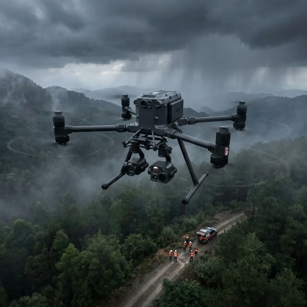
Construction monitoring in broken terrain is rarely a simple “fly, capture, report” exercise. Sloped access roads, unstable cut faces, dust, changing light, and blocked lines of sight all stack risk onto what should be a repeatable documentation job. That is where a platform like the Matrice 400 becomes useful—not because the airframe alone solves everything, but because it supports disciplined workflows that hold up when the site gets messy.
I approach the Matrice 400 as a systems tool. For construction teams working across ridgelines, retaining walls, quarry edges, and staged earthworks, the aircraft matters less than the reliability of the whole chain: sensor choice, transmission integrity, battery management, data handling, and the operator’s ability to switch methods quickly when conditions shift.
This tutorial is built around that reality.
Start with the mission, not the drone
On a complex construction site, there are usually three separate monitoring jobs happening at once:
- Progress recording for stakeholders and contractors
- Measurement and mapping for quantities, terrain change, and alignment checks
- Risk detection for drainage issues, heat anomalies, unstable surfaces, or equipment congestion
The Matrice 400 can support all three, but only if the flight plan is structured around outputs rather than sorties. A thermal signature pass at dawn answers a different question than a photogrammetry mission at solar noon. A low oblique sweep for façade and slope inspection is not the same as a high-overlap nadir grid for stockpile volume calculation.
The common mistake is trying to compress all deliverables into one flight window. On difficult terrain, that usually leads to compromised imagery, poor ground control distribution, or rushed battery swaps.
Why transmission resilience matters more than most teams expect
Construction sites with elevation changes are hostile to clean signal paths. A ridge can mask the aircraft even when it is geographically close. Tower cranes, reinforced structures, temporary metal site offices, and moving plant all add interference or visual obstruction. In that environment, robust O3 transmission is not just a spec sheet talking point. It is part of operational confidence.
For site monitoring, strong transmission has two direct consequences.
First, it helps the pilot maintain image awareness when the terrain creates partial occlusion. That matters when you are tracking a route along a bench cut or checking haul road drainage beyond a crest line. Second, it reduces the temptation to reposition hastily mid-mission, which often creates continuity problems in repeat surveys.
If your team is preparing for extended corridor work or future BVLOS operations where regulations permit, transmission planning should be treated like survey planning. Establish high points for launch, define terrain shadow zones in advance, and decide which sections are better flown as separate blocks rather than one continuous route.
Thermal is not a bonus payload on construction work
Many teams still treat thermal as something reserved for utilities or emergency response. On a complex construction site, that leaves useful information on the table.
A thermal signature pass can reveal:
- water accumulation behind temporary retaining features
- abnormal heating in electrical installations or site cabins
- recently compacted zones that are drying unevenly
- friction-related heat around machinery operating areas
- buried service routes showing differential surface temperature under certain conditions
The value is not in spotting “hot things.” It is in identifying patterns that the visible spectrum can miss during a standard progress flight.
For example, after rainfall, a steep access road may look acceptable in RGB imagery while thermal highlights persistent moisture bands that suggest poor drainage or seepage. That becomes operationally significant because those zones often degrade first under heavy vehicle use. Thermal turns a visual record into an early warning layer.
Timing matters. Fly thermal close to conditions that amplify contrast: early morning, late afternoon, or after environmental change such as rainfall, dewatering, or heavy equipment activity. Then compare those results with RGB ortho outputs rather than reviewing thermal in isolation.
Photogrammetry in rough terrain: where accuracy is won or lost
The Matrice 400’s role in photogrammetry becomes especially valuable when the site includes multiple elevations, embankments, excavation faces, and partial vertical structures. Flat-site habits do not transfer well here.
A successful terrain model in this environment depends on four things:
1. GCP strategy that matches the topography
If you use GCP placements as if the site were level, the model will drift where it matters most—on slopes, transitions, and edge features. Spread control vertically as well as horizontally. Put targets on upper benches, lower haul areas, and transition points between cut and fill. This tightens surface reconstruction where grade interpretation matters.
2. Mixed capture geometry
Pure nadir capture can be enough for simple earthworks, but it often underperforms around steep faces, retaining systems, and stockpiles with sharp geometry. Adding oblique imagery improves reconstruction, especially when the site includes stepped excavation or exposed rock faces.
3. Light discipline
Harsh shadows across terraced areas create matching issues. If the site has deep cuts or high retaining elements, schedule mapping closer to diffuse light conditions when possible. Even a technically perfect grid can produce weaker outputs if contrast varies too much between benches.
4. Repeatability
Construction monitoring is rarely about one model. It is about change over time. Keep altitude, overlap, camera angle, and route logic as consistent as the site allows. The Matrice 400 becomes more valuable when it supports repeatable capture standards, not just one-off flights.
Hot-swap batteries change field rhythm
On a large or topographically awkward site, battery workflow directly affects data quality. Hot-swap batteries are more than a convenience feature. They preserve mission continuity.
That matters in practical ways. If your team is documenting a terrain-sensitive sequence—say, a drainage corridor or staged slope stabilization area—you want the shortest possible interruption between flights. Long breaks change shadows, machinery positions, and even surface conditions. Hot-swapping reduces those discontinuities.
It also helps when weather windows are narrow. In mountain-adjacent or exposed sites, wind can shift quickly. The ability to land, change power, and relaunch without dragging the operation into a long reset can make the difference between a complete dataset and a patchy one.
My advice is simple: assign one crew member specifically to battery readiness and cooling discipline. Do not make the pilot manage everything. Efficient battery rotation is part of the capture system.
A useful lesson from aviation control design
One of the more interesting reference points behind disciplined UAV operations comes from traditional aircraft system design. In one aircraft design manual, the control philosophy for a hose-and-drogue pod is built around clearly separated switch actions for deploy and rewind, with specific procedures for abnormal conditions. The same section also describes a dedicated dump function used when fuel temperature exceeds a limit, with the operator opening the switch, releasing hot fuel, and stopping once the warning clears.
That is not drone guidance, of course. But the operational logic is highly relevant to Matrice 400 work on construction sites.
Two details stand out.
The first is the value of distinct control states. In the manual, “deploy” and “rewind” are not vague operator intentions; they are defined commands tied to specific system behavior. For drone crews, the lesson is to build similarly explicit mode discipline into site monitoring. Mapping mode, thermal inspection mode, and close visual inspection mode should not blur together. Predefine what each mode means: speed, altitude band, sensor setup, overlap, and abort criteria.
The second is response to over-limit conditions. The manual’s temperature-triggered dump procedure is a reminder that high-value systems need simple, direct actions when a threshold is crossed. For Matrice 400 operations, that mindset applies to battery temperature, downlink degradation, wind escalation, or payload warnings. Instead of ad hoc decision-making, crews should use written responses: reduce leg length, return to a relay-safe waypoint, suspend thermal capture, or terminate the sortie.
This is where professional drone programs separate themselves from casual aerial content work. The aircraft is sophisticated, but the real safety and data quality gains come from control logic the crew can execute without hesitation.
Wiring, heat, and why payload integration deserves scrutiny
A second reference source, focused on aircraft materials, highlights electrical wire families such as M22759/2 and M22759/4, and notes a performance figure reaching 260 in the material data. The broader relevance here is not that a Matrice 400 operator needs to become an aerospace wiring engineer. It is that thermal tolerance and insulation quality are not abstract concerns when you start expanding payload capability.
This becomes especially relevant when adding a third-party accessory.
One upgrade I have seen improve construction monitoring is a third-party spotlight or loudspeaker integration mount paired with a custom data or power harness for specialized site coordination and low-light perimeter documentation. The capability gain can be real, especially on sprawling projects with early-morning inspections or twilight shutdown checks. But the accessory itself is only half the story. The integration quality matters just as much.
Poor cable routing, weak shielding, and heat buildup near connectors can introduce intermittent problems that appear random in the field: unstable payload communication, noisy video, or unreliable startup behavior. The reference to high-spec wire classes and heat-performance criteria is a useful reminder that accessory ecosystems should be judged by their electrical discipline, not just by what they promise on a brochure.
For teams planning custom Matrice 400 integrations, ask hard questions:
- How is the accessory powered?
- What insulation and cable protection are used?
- How is strain relief handled during transport and flight vibration?
- What is the thermal behavior during sustained operation?
- Does installation compromise weather sealing or service access?
Those questions save time later.
AES-256 is operational, not administrative
A lot of site teams hear AES-256 and think “IT department issue.” That is shortsighted. Construction monitoring often involves pre-completion structures, utility routes, staging plans, contractor sequencing, and imagery that can expose commercial sensitivities.
Strong encryption matters because the drone is not just collecting pretty overviews. It is carrying project intelligence.
On complex sites with multiple subcontractors, visiting consultants, and shared temporary networks, secure data handling should be designed into the mission. Decide before launch:
- what media is stored locally
- what is transmitted live
- who can access the footage
- how survey outputs are named and archived
- which datasets are stripped of sensitive context before external sharing
The Matrice 400 becomes more useful when it slots cleanly into a controlled information environment.
A practical field workflow for Matrice 400 on difficult sites
Here is the sequence I recommend for recurring construction monitoring.
Pre-site planning
Review the latest topographic changes, machine activity zones, and known signal shadow areas. Mark likely launch and alternate landing points. Prepare separate flight templates for mapping, thermal, and inspection.
Ground setup
Verify GCP distribution across elevation bands, not just across plan view. Check whether new cuts, stockpiles, or scaffold structures now block previous routes.
First flight: broad visual reconnaissance
Use this pass to confirm site changes, identify temporary hazards, and validate whether your mapping plan still fits reality.
Second flight: photogrammetry mission
Run the repeatable grid with the overlap and geometry needed for terrain reconstruction. Add obliques if the site includes steep faces or structural edges.
Third flight: thermal pass
Capture areas where water, heat, or material inconsistency may create operational issues. Keep this mission focused. Thermal produces the most value when it is linked to a question.
Targeted follow-up inspection
Use the Matrice 400 for closer documentation of any anomalies detected in earlier passes.
Post-flight review
Do not wait until office processing to discover gaps. Review coverage, thermal contrast, and control visibility in the field while a relaunch is still practical.
If your team is refining this workflow for a live project and wants a direct field-operations discussion, you can message a UAV specialist here.
What makes Matrice 400 genuinely effective here
For complex terrain construction monitoring, the Matrice 400’s value is not one isolated feature. It is the combination of stable transmission, secure data handling, efficient battery turnover, and enough payload flexibility to support both mapping and inspection logic in the same program.
That matters because difficult sites punish fragmented workflows. If one system handles imagery but not thermal, or one aircraft maps well but slows the team down on repeat launches, operational friction builds quickly. The stronger approach is to use the Matrice 400 as the center of a disciplined monitoring architecture.
And that architecture should be built with the same seriousness found in traditional aircraft systems design: clear switch states, clear thresholds, clear responses, and components chosen for reliability under heat, vibration, and repetitive use.
That is how a drone stops being an occasional documentation tool and becomes a dependable site intelligence platform.
Ready for your own Matrice 400? Contact our team for expert consultation.