Advanced Coastal Monitoring with the Matrice 400
Advanced Coastal Monitoring with the Matrice 400
META: Discover how the DJI Matrice 400 transforms coastal field monitoring with thermal imaging, BVLOS capability, and hot-swap batteries for uninterrupted operations.
TL;DR
- The Matrice 400 solves critical battery and data continuity challenges unique to coastal monitoring environments with salt air, wind, and vast coverage areas.
- O3 transmission and AES-256 encryption ensure reliable, secure data links across extended coastal ranges.
- Hot-swap batteries enable true continuous flight operations, eliminating costly downtime during time-sensitive agricultural and environmental surveys.
- Thermal signature detection paired with photogrammetry delivers multi-layered field intelligence that single-sensor platforms simply cannot match.
The Coastal Monitoring Problem Nobody Talks About
Coastal field monitoring punishes unprepared operators. Salt-laden air corrodes components, persistent crosswinds drain batteries 20–30% faster than inland operations, and the sheer acreage of coastal agricultural zones demands coverage that most enterprise drones cannot sustain in a single mission cycle. If you're running environmental surveys, crop health assessments, or erosion monitoring along the coast, you already know the frustration of interrupted flights and fragmented datasets.
This guide breaks down exactly how the DJI Matrice 400 addresses these operational pain points—and shares hard-won field techniques from hundreds of hours monitoring coastal corridors.
I'm James Mitchell. I've spent the better part of a decade deploying enterprise drones in some of the most demanding coastal environments across the Atlantic and Gulf regions. The Matrice 400 has fundamentally changed how my team approaches large-area monitoring, and what follows is everything I wish I'd known before my first coastal deployment.
Why Coastal Environments Demand a Different Drone
Standard enterprise drones treat coastal work as an afterthought. The Matrice 400 was designed with the exact operational profile that harsh marine-adjacent environments require.
Wind Resistance and Flight Stability
Coastal fields rarely offer calm conditions. The Matrice 400 maintains stable flight in sustained winds up to 12 m/s (approximately 27 mph), with burst tolerance even higher. This matters because photogrammetry accuracy degrades rapidly when a platform cannot hold position. Blurred captures from a less capable drone mean re-flying entire grid sections—burning time and battery you cannot afford.
Corrosion and Environmental Resilience
The Matrice 400 carries an IP55 ingress protection rating, shielding internal electronics from salt spray and the fine sand that coastal operations inevitably introduce. I've operated units in morning fog conditions where visibility was marginal but the airframe showed zero moisture ingress upon post-flight inspection.
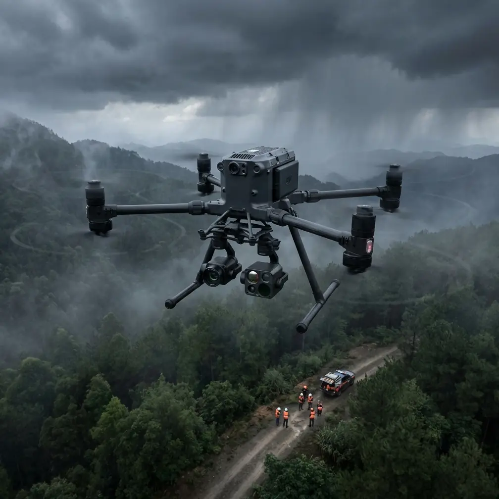
Thermal Signature Detection for Coastal Field Intelligence
One of the most powerful capabilities the Matrice 400 unlocks for coastal monitoring is dual-sensor thermal and RGB imaging. Thermal signature analysis goes far beyond simple temperature readings.
Practical Applications in Coastal Fields
- Crop stress identification: Thermal signatures reveal irrigation failures and salt intrusion damage days before visual symptoms appear.
- Drainage mapping: Subsurface water flow patterns become visible through temperature differentials in early morning flights.
- Wildlife and habitat surveys: Coastal buffer zones often require environmental compliance monitoring—thermal makes fauna detection reliable even in dense vegetation.
- Infrastructure assessment: Seawalls, drainage culverts, and pump stations show structural weaknesses through heat differential patterns.
Expert Insight: Schedule thermal flights during the first 90 minutes after sunrise along coastal zones. The temperature differential between soil, vegetation, and water features is at its maximum, producing thermal signatures with the highest contrast and analytical value. Afternoon flights in coastal areas suffer from thermal saturation that flattens your data.
Photogrammetry and GCP Workflow for Accurate Coastal Maps
Generating survey-grade orthomosaics and elevation models from coastal flights requires disciplined ground control point (GCP) placement. The Matrice 400's onboard RTK module provides centimeter-level positioning accuracy, but GCPs remain essential for verifiable precision.
GCP Best Practices for Coastal Terrain
- Place GCPs on stable, non-shifting surfaces—avoid sand and loose soil near tidal zones.
- Use a minimum of 5 GCPs per survey block, with at least one in the center of the flight area.
- Anchor GCP targets with stakes rated for wind; coastal gusts will relocate unsecured panels mid-flight.
- Log GCP coordinates with a base station using NTRIP corrections for consistency across multi-day campaigns.
The Matrice 400's camera gimbal stabilization ensures that even in turbulent coastal air, each capture aligns precisely with the flight plan grid, reducing photogrammetry stitching errors by a significant margin compared to less rigid platforms.
O3 Transmission and AES-256 Encryption: Reliable and Secure
Coastal monitoring often pushes range limits. The Matrice 400's O3 transmission system delivers a reliable video and control link at distances that support BVLOS (Beyond Visual Line of Sight) operations—critical when monitoring elongated coastal parcels that stretch for kilometers.
Why This Matters Operationally
- O3 transmission maintains 1080p live feed quality at extended range, even in environments with RF interference from nearby marine communications equipment.
- AES-256 encryption protects all data in transit, which is non-negotiable for government-contracted environmental surveys and agricultural data that falls under privacy regulations.
- Automatic frequency hopping reduces dropout risk in congested RF coastal environments near ports and populated shorelines.
| Feature | Matrice 400 | Typical Mid-Range Enterprise Drone |
|---|---|---|
| Max Wind Resistance | 12 m/s sustained | 8–10 m/s |
| Transmission System | O3 (AES-256 encrypted) | OcuSync 2.0 or Wi-Fi |
| Ingress Protection | IP55 | IP43–IP44 |
| Hot-Swap Batteries | Yes | No |
| RTK Positioning | Centimeter-level | Meter-level (GPS only) |
| Max Flight Time | Up to 50 minutes | 30–38 minutes |
| BVLOS Readiness | Full compliance capable | Limited |
| Thermal Payload Support | Native dual-sensor | Aftermarket or single-sensor |
Hot-Swap Batteries: The Field Technique That Changed Everything
Here is the single most impactful lesson from my coastal fieldwork: battery management is mission management. The Matrice 400's hot-swap battery system allows you to replace one battery while the other keeps the drone powered and hovering. This sounds simple on paper. In practice, it transforms coastal operations entirely.
The Field Tip That Saves Hours
During a 3,200-acre coastal erosion survey along the Carolina Outer Banks, my team needed continuous data collection across a 6-hour window tied to tidal conditions. Landing, powering down, swapping batteries, rebooting, recalibrating, and relaunching on a conventional platform costs 8–12 minutes per cycle. Over a full day, that adds up to over an hour of dead time.
With the Matrice 400, we developed a rotation system: three battery sets, staggered charging on a vehicle-mounted power station. One set flies, one set charges, one set stands by at full charge. We executed hot swaps in under 45 seconds without ever killing the mission. The drone maintained its GPS lock, its flight plan position, and its sensor calibration through every swap.
Pro Tip: Label each battery set with colored tape (we use red, blue, and green) and log cycle counts per set in a simple spreadsheet after every field day. Coastal humidity accelerates lithium cell degradation unevenly. After 150 cycles, compare voltage sag rates between sets under identical load. Retire any set showing more than 0.3V differential between cells under load—flying a degraded pack in coastal crosswinds is a risk that no dataset is worth.
Pre-Flight Battery Protocol for Coastal Work
- Never store fully charged packs overnight in humid coastal air—discharge to 60% storage voltage if not flying next day.
- Warm batteries to at least 20°C before flight if operating during cool coastal mornings.
- Keep battery contacts clean using isopropyl alcohol wipes; salt residue on terminals creates resistance and unreliable power delivery.
- Always carry one more battery set than your mission plan requires—coastal winds will increase consumption beyond your software estimates.
BVLOS Operations: Expanding the Coastal Envelope
The Matrice 400 is built for BVLOS-compliant operations, which is where coastal monitoring truly scales. Linear coastline surveys, pipeline corridor inspections, and large agricultural blocks all benefit from the ability to fly beyond the pilot's direct visual range under proper regulatory approval.
Key BVLOS enablers on the Matrice 400 include:
- Redundant flight control systems with automatic failsafe return-to-home.
- ADS-B receiver for manned aircraft awareness in shared coastal airspace.
- Real-time telemetry via O3 transmission providing continuous aircraft health data.
- Geofencing and altitude caps programmable per mission to satisfy waiver requirements.
Securing a Part 107 BVLOS waiver from the FAA requires demonstrating these exact capabilities. The Matrice 400's specification sheet reads like a checklist against waiver requirements, which accelerates the approval process considerably.
Common Mistakes to Avoid
Flying without a coastal-specific pre-flight checklist. Inland checklists miss salt exposure inspection, wind gradient assessment at altitude, and tide-dependent launch site viability. Build a separate protocol for every coastal deployment.
Ignoring magnetic interference near coastal structures. Metal seawalls, buried pipelines, and dock infrastructure cause compass errors. Always calibrate the Matrice 400's compass at the launch site, not at your hotel parking lot.
Scheduling flights around convenience instead of conditions. Thermal signature quality, wind patterns, and lighting angles vary dramatically throughout a coastal day. Plan flights around data quality windows, not crew comfort.
Overlooking data backup in the field. Salt air and humidity threaten SD cards and onboard storage. Offload and verify data to a ruggedized drive after every flight—not at the end of the day.
Neglecting post-flight airframe cleaning. Even a single day of coastal operation deposits enough salt to begin corroding exposed metal components. Wipe down the entire Matrice 400 airframe with a damp microfiber cloth after every session.
Frequently Asked Questions
Can the Matrice 400 handle heavy fog common in coastal environments?
Yes. The IP55 rating protects against moisture ingress from fog and light rain. The thermal sensor also remains fully functional in low-visibility conditions, allowing productive data collection when RGB cameras lose effectiveness. That said, always comply with local aviation visibility minimums for legal flight operations.
How does the Matrice 400 handle GPS signal quality near large bodies of water?
The Matrice 400 utilizes multi-constellation GNSS (GPS, GLONASS, Galileo, BeiDou) and its onboard RTK module to maintain centimeter-level accuracy. Water surfaces can cause GPS multipath reflections, but the RTK system compensates effectively. For highest accuracy during photogrammetry missions, supplementing with ground control points remains a best practice.
What payload configurations work best for coastal agricultural monitoring?
For comprehensive coastal field intelligence, the dual thermal-RGB payload is the most versatile configuration. Thermal signatures identify crop stress and drainage anomalies, while the RGB sensor produces the high-resolution imagery needed for photogrammetry-based volumetric and topographic analysis. If your mission focuses exclusively on mapping, a dedicated photogrammetry camera with mechanical shutter minimizes rolling shutter distortion during higher-speed coastal flight plans.
The Matrice 400 is not merely an upgrade—it is a category shift for anyone serious about sustained, accurate, and secure coastal monitoring operations. From hot-swap battery endurance to encrypted O3 data links and BVLOS-ready compliance architecture, every subsystem addresses a real problem that coastal operators face daily.
Ready for your own Matrice 400? Contact our team for expert consultation.