Matrice 400 for Coastal Field Monitoring: Altitude, Sensors
Matrice 400 for Coastal Field Monitoring: Altitude, Sensors, and Flight Workflow That Actually Hold Up
META: Practical Matrice 400 tutorial for coastal field monitoring, covering optimal flight altitude, thermal use, photogrammetry, GCP strategy, O3 transmission, AES-256 security, hot-swap batteries, and BVLOS planning.
Coastal field monitoring looks simple on paper. Wide open land. Clear sightlines. Big blocks that seem easy to cover from the air.
Then you get on site.
Salt haze softens contrast. Wind direction shifts halfway through a mission. Wet ground reflects light unpredictably. Crops near estuaries often show stress patterns that do not read the same way they do inland. If you are flying a Matrice 400 in this environment, success comes down to one thing: building a mission profile that respects both the aircraft’s capabilities and the quirks of the coastline.
This tutorial is built around that practical reality. Not generic drone advice. Not a broad overview. Specifically, how to use a Matrice 400 for field monitoring in coastal conditions, with attention to flight altitude, thermal interpretation, photogrammetry workflow, transmission stability, and battery strategy.
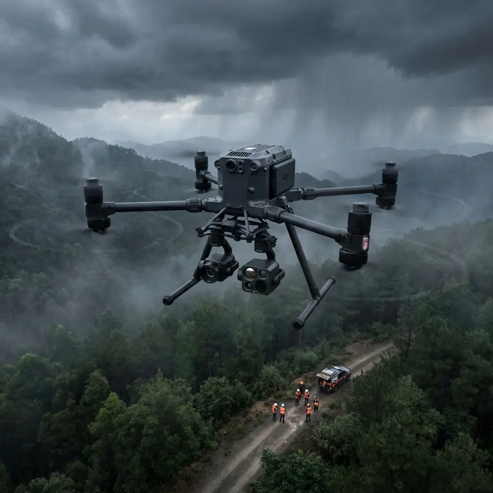
Why the coastal environment changes your Matrice 400 setup
A Matrice 400 is not just a bigger platform for covering more hectares. In coastal agriculture and land monitoring, its value comes from how well it supports repeatable data capture when the environment is unstable.
Coastal fields tend to produce three problems at once:
- Wind variability
- Moisture-driven reflectivity
- Mixed stress signatures across vegetation and soil
That combination affects your image consistency, your overlap quality, and your confidence in what you are seeing. A stressed patch of crop might be root-zone salinity. Or temporary heat loading from exposed wet soil. Or wind-driven evapotranspiration on a field edge. The drone can only help if the mission is flown in a way that makes those differences readable.
This is where the Matrice 400’s operational stack matters. Strong transmission performance through O3 transmission, secure data handling with AES-256, and the practical advantage of hot-swap batteries all support a workflow that is less interrupted and more defensible when you are collecting recurring field data.
Those are not brochure features in this use case. They directly affect whether you can run a stable monitoring program across long field blocks near the coast.
The best flight altitude for coastal field monitoring
Let’s get to the most useful question first.
My starting recommendation: fly most coastal crop-monitoring missions at 70 to 90 meters AGL
For a Matrice 400 monitoring fields in coastal conditions, 70 to 90 meters above ground level is the sweet spot for most routine visual and thermal survey work.
Why that band works:
- It gives you enough coverage to stay efficient over large plots
- It reduces the exaggerated motion effect you get when flying too low in gusty coastal wind
- It helps maintain more uniform image geometry for photogrammetry
- It still preserves enough detail to identify drainage issues, stand inconsistency, salinity patterns, and irrigation anomalies in many field-monitoring scenarios
If your goal is broad crop health screening or repeated condition mapping, starting around 80 meters AGL is usually the most balanced choice.
When to go lower: 40 to 60 meters AGL
Drop lower if you are trying to confirm subtle anomalies rather than discover them.
For example:
- checking irregular thermal edges along drainage channels
- validating suspected salinity intrusion near coastal margins
- inspecting patchy emergence zones
- examining lodging or storm damage after a weather event
At 40 to 60 meters, thermal and RGB detail become more diagnostic, but the tradeoff is reduced area coverage and more sensitivity to wind-induced motion. On coastal sites, that matters. If gusts are already moving the aircraft around, low-altitude missions can create inconsistent image overlap and weaker map outputs.
When to go higher: 100 to 120 meters AGL
There are times to climb.
If you are covering very large open fields and need fast situational awareness after rain, flooding, or tidal influence, a higher overview pass at 100 to 120 meters can help you identify where to spend your lower-altitude flight time. It is also useful when you want to see field-to-field relationships such as drainage flow direction, berm breaches, or standing water connected across multiple parcels.
For detailed agronomic interpretation, though, I would not make this your default altitude. In coastal monitoring, the higher you go, the more you risk flattening small but meaningful differences in canopy and soil condition.
Thermal signature reading near the coast: what changes
Thermal work in coastal environments is valuable, but it is easy to misread.
The phrase thermal signature sounds precise. In the field, it is conditional.
Coastal humidity, wet soils, shallow standing water, and salt-affected zones all influence surface temperature behavior. A thermal anomaly does not automatically mean plant stress. Sometimes it means different moisture retention. Sometimes it means exposed ground. Sometimes it is simply a time-of-day artifact.
With the Matrice 400, the practical lesson is this:
Use thermal as a decision layer, not a standalone verdict
Thermal is strongest when paired with repeat flights and visual context. A warm patch near a coastal field edge becomes much more meaningful if:
- it appears consistently across multiple flights
- it aligns with topography or drainage patterns
- it matches RGB signs of reduced vigor
- it sits near a known irrigation or salinity risk area
For this reason, I recommend a two-pass approach:
- Pass one at 80 meters AGL for broad anomaly detection
- Pass two at 50 meters AGL over specific flagged zones
That structure helps you avoid overreacting to single-frame temperature differences that can be exaggerated by moisture and surface reflectance.
Also be disciplined about timing. Coastal sites can warm unevenly as sea breeze patterns shift. If your goal is comparison across dates, fly at the same relative time window whenever possible.
Photogrammetry in coastal fields: accuracy depends on discipline, not just aircraft quality
The Matrice 400 can support serious mapping work, but coastal field monitoring punishes lazy photogrammetry.
The issue is not only wind. It is also visual uniformity. Large agricultural blocks, especially those with repetitive planting structure or wet reflective surfaces, can make image matching more difficult. That is where mission planning matters.
Use strong overlap and keep your geometry repeatable
For field monitoring workflows, consistency beats experimentation. If you are building repeatable maps across a season, keep these variables stable:
- altitude
- speed
- flight direction
- overlap settings
- time of day when possible
Changing too many inputs between missions makes field comparisons weaker, even if every single flight looks acceptable in isolation.
GCPs are still worth it in open agricultural blocks
If the project requires reliable map alignment over time, use GCPs. In coastal terrain, where subtle elevation and drainage shifts can have outsized agronomic effects, accurate georeferencing is not optional if your outputs are meant to guide decisions.
A few well-placed Ground Control Points can tighten your dataset and help avoid drift between repeated surveys. This is especially important if you are comparing drainage movement, erosion edges, levee conditions, or changes along field margins after weather events.
Operationally, that means the Matrice 400 is not the whole system. The aircraft gives you the platform stability and coverage. GCPs give your maps accountability.
O3 transmission matters more on the coast than many operators realize
A lot of pilots treat transmission specifications as a convenience feature. For coastal field monitoring, I see it differently.
O3 transmission matters because coastal operations often involve long sightlines, sparse landmarks, changing weather, and a false sense of simplicity. The field may look open, but atmospheric conditions can still interfere with clean operation and confidence in live monitoring.
Reliable transmission affects:
- framing and route verification
- confidence in real-time anomaly review
- mission continuity over larger parcels
- safer and more efficient edge-of-range operations within regulations
If you are working under a BVLOS framework where it is legally approved and operationally structured, transmission reliability becomes even more significant. I am not talking about using BVLOS casually. I mean properly planned commercial operations where larger agricultural properties make beyond-visual-line-of-sight workflows relevant.
In those scenarios, the Matrice 400’s transmission capability is not just about convenience. It supports better oversight of the data collection process itself.
AES-256 is not an abstract spec in agricultural operations
Most people hear AES-256 and think corporate IT checklist.
But if you are monitoring commercial farmland, contract-managed estates, research plots, or sensitive yield data, secure transmission and data handling matter. Some field-monitoring operations involve proprietary crop trials, irrigation strategy comparisons, or land-condition records that clients do not want moving through weak security chains.
That is why AES-256 has practical significance. It helps support a professional workflow where data security is treated as part of the service, not an afterthought.
For consultants and operators managing recurring monitoring contracts, this becomes part of trust. Not marketing language. Trust.
Hot-swap batteries change the pace of field work
This is one of those features that only becomes fully appreciated after a long day in the field.
Hot-swap batteries reduce downtime between flights, which is especially useful when coastal weather gives you a narrow stable window. If you have a two-hour period with manageable wind, decent light, and consistent thermal conditions, you do not want to waste that window on drawn-out resets.
In practical terms, hot-swap capability helps you:
- maintain mission continuity across large blocks
- preserve timing consistency between adjacent fields
- finish follow-up passes before environmental conditions shift
- move from survey mode to targeted inspection mode without losing momentum
That matters more on the coast than inland. Conditions can change quickly. When they do, a small delay can produce a visibly different dataset.
A simple mission template for coastal field monitoring with Matrice 400
Here is a field-ready workflow I recommend as a starting point.
1. Pre-site review
Before flight, check:
- wind direction and expected gusts
- tide or water-level influence if fields are close to estuarine boundaries
- recent rain and drainage status
- sun angle and expected glare zones
2. First mapping pass
Fly at 80 meters AGL.
Use this pass to:
- map the entire field block
- identify broad crop stress regions
- review drainage and pooling patterns
- create your base visual and thermal dataset
3. Mark suspect zones
Look for:
- warm field edges
- linear stress patterns following drains or irrigation lines
- irregular patches near coastal margins
- low-lying sections with delayed drying
4. Second diagnostic pass
Fly flagged areas at 50 meters AGL.
This is where the Matrice 400 earns its keep. You are no longer just covering land. You are investigating specific field behavior with better detail and stronger context.
5. Use GCP-backed processing where accuracy matters
If outputs will be compared over time or used in technical reporting, integrate GCPs into the workflow.
6. Keep records standardized
Log:
- altitude
- wind conditions
- time of day
- camera or sensor mode
- battery sequence
- field moisture context
Without standardized records, repeat monitoring turns into guesswork.
One mistake I see often: flying too low too early
Operators new to coastal field work often think lower altitude always means better insight.
Usually, it means they spend too much time collecting beautiful detail before they understand the field-wide pattern.
Start broader. Build context. Then descend.
For most Matrice 400 coastal monitoring jobs, that means beginning around 80 meters and only going lower after the first-pass map tells you where the real questions are.
That sequence saves battery cycles, improves interpretation, and produces cleaner reporting.
Final practical takeaway
If you are using a Matrice 400 to monitor fields in coastal areas, do not treat it as a simple coverage machine. Treat it as a platform for controlled comparison.
The best default altitude is usually 70 to 90 meters AGL, with 80 meters as the strongest starting point for broad field assessment. Drop to 40 to 60 meters when you need to diagnose anomalies, and only go higher for fast overview work across very large parcels.
Pair thermal observations with visual context. Use photogrammetry consistently. Bring in GCPs when map reliability matters. Lean on O3 transmission when long agricultural blocks demand stable oversight, respect AES-256 when handling client-sensitive field data, and use hot-swap batteries to protect your narrow weather window.
That is the difference between flying a mission and building a monitoring system.
If you are planning a coastal agriculture workflow and want to compare payload, altitude, or mapping setup for your site, you can message our UAV team directly here.
Ready for your own Matrice 400? Contact our team for expert consultation.