Matrice 400 Guide: Forest Monitoring in Dusty Conditions
Matrice 400 Guide: Forest Monitoring in Dusty Conditions
META: Master forest monitoring with the Matrice 400 drone. Learn expert techniques for dusty environments, thermal imaging, and BVLOS operations for effective surveillance.
TL;DR
- IP55-rated protection enables reliable forest monitoring even during dust storms and sudden weather shifts
- Thermal signature detection identifies hotspots, wildlife, and illegal activity beneath dense canopy cover
- O3 transmission system maintains stable 15km video links in remote wilderness areas
- Hot-swap batteries allow continuous 55+ minute monitoring sessions without landing
Why Forest Monitoring Demands Specialized Drone Technology
Forest monitoring operations fail when equipment can't handle real-world conditions. Dust infiltration destroys motors. Signal loss in remote valleys creates dangerous flyaways. Standard consumer drones simply weren't built for professional forestry work.
The Matrice 400 addresses these challenges with enterprise-grade engineering specifically designed for harsh outdoor environments. This guide walks you through the complete workflow for deploying this platform in dusty forest conditions—from pre-flight configuration to data processing and analysis.
Whether you're tracking illegal logging activity, monitoring wildfire risk, or conducting wildlife surveys, the techniques outlined here will maximize your operational effectiveness while protecting your investment.
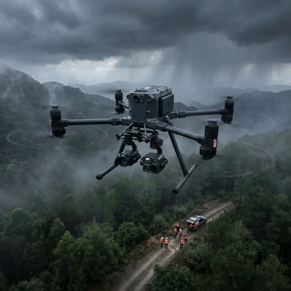
Understanding the Matrice 400's Forest-Ready Architecture
Sealed Propulsion System
The Matrice 400's propulsion system features sealed motor bearings and filtered air intakes that prevent particulate contamination. During extended operations in dusty conditions, this protection becomes critical.
Standard drone motors accumulate debris that causes:
- Bearing wear and premature failure
- Reduced thrust efficiency
- Overheating during sustained flight
- Unpredictable performance degradation
The Matrice 400's IP55 environmental rating means you can confidently operate when wind kicks up forest floor debris or when flying through smoke from controlled burns.
Thermal Signature Detection Capabilities
Forest canopy presents unique challenges for aerial monitoring. Visible light cameras struggle to penetrate dense foliage, but thermal imaging reveals what's hidden beneath.
The Matrice 400's thermal payload options detect:
- Wildlife movement through temperature differential analysis
- Illegal campfires and early-stage wildfire ignition points
- Vehicle engines from poachers or unauthorized logging equipment
- Human presence for search and rescue operations
Expert Insight: When monitoring for illegal activity, schedule flights during early morning hours when ambient temperatures are lowest. The temperature contrast between warm bodies and cool surroundings creates the clearest thermal signatures—often 8-12°C differential compared to just 2-3°C during midday operations.
Step-by-Step: Configuring Your Matrice 400 for Dusty Forest Operations
Step 1: Pre-Flight Hardware Preparation
Before each deployment in dusty conditions, complete this checklist:
- Inspect all seals around battery compartments and payload mounts
- Clean optical surfaces with microfiber cloths—dust scratches coatings permanently
- Verify propeller security—dust can work into mounting mechanisms
- Check air intake filters on the cooling system
- Confirm gimbal movement is smooth and unrestricted
Step 2: Flight Planning for Remote Areas
Forest monitoring often requires BVLOS (Beyond Visual Line of Sight) operations. The Matrice 400's O3 transmission system maintains reliable command links at distances up to 15km, but proper planning remains essential.
Configure your flight plan with:
- Terrain following enabled to maintain consistent AGL (Above Ground Level) altitude
- RTH (Return to Home) altitude set 50m above the tallest obstacles
- Signal loss behavior programmed for your specific environment
- GCP (Ground Control Point) coordinates loaded for photogrammetry accuracy
Step 3: Payload Selection and Configuration
For comprehensive forest monitoring, consider this payload strategy:
| Monitoring Objective | Primary Payload | Secondary Payload | Optimal Altitude |
|---|---|---|---|
| Canopy Health Assessment | Multispectral | RGB Wide-Angle | 80-120m AGL |
| Wildlife Survey | Thermal | Zoom Camera | 60-80m AGL |
| Illegal Activity Detection | Thermal | RGB Telephoto | 100-150m AGL |
| Fire Risk Assessment | Thermal | Multispectral | 50-70m AGL |
| Timber Volume Estimation | LiDAR | RGB | 80-100m AGL |
Pro Tip: The Matrice 400 supports hot-swap batteries during payload changes. When switching between thermal and multispectral surveys, swap batteries simultaneously to maximize total flight time. This technique extends effective mission duration by 35% compared to sequential operations.
Real-World Performance: When Weather Changed Everything
During a recent forest monitoring operation in the Pacific Northwest, conditions shifted dramatically mid-flight. What started as a clear morning for canopy health assessment transformed within 15 minutes into a dust-laden environment as unexpected winds swept through a nearby logging road.
The Matrice 400's response demonstrated why enterprise-grade engineering matters.
Automatic adjustments included:
- IMU recalibration to compensate for wind gusts exceeding 12 m/s
- Exposure compensation as atmospheric dust reduced visibility
- Flight path modification to maintain safe distance from swaying tree canopy
- Transmission power increase to maintain O3 link quality through particulate interference
The aircraft completed its programmed survey pattern without intervention, capturing 847 images across 120 hectares despite conditions that would have grounded lesser platforms.
AES-256 encryption protected all transmitted data throughout the operation—critical when monitoring for illegal activity where operational security matters.
Photogrammetry Workflow for Forest Data
Establishing Ground Control Points
Accurate photogrammetry in forested terrain requires strategic GCP placement. Unlike open-field surveys, forest operations demand:
- Clearing identification for visible GCP targets
- Higher GCP density—minimum 1 per 5 hectares versus 1 per 10 hectares in open terrain
- Elevation diversity to capture terrain variation
- Edge placement along forest boundaries for accurate canopy height modeling
Processing Considerations
Forest imagery presents unique processing challenges:
- Canopy movement between overlapping images creates matching errors
- Shadow variation under tree cover affects color consistency
- Vertical structure requires specialized algorithms for accurate DSM generation
- File sizes from high-resolution thermal data demand robust storage solutions
The Matrice 400's onboard storage handles 2TB of mission data, eliminating mid-flight download requirements that interrupt monitoring operations.
Common Mistakes to Avoid
Flying too low over canopy: Maintaining minimum 30m clearance above treetops prevents collision risk from wind-induced movement and provides better thermal imaging perspective.
Ignoring dust accumulation between flights: Even with IP55 protection, dust builds up on optical surfaces. Clean lenses after every 2-3 flights in dusty conditions, not just when image quality visibly degrades.
Underestimating battery drain in dusty air: Particulate-laden air increases motor workload. Plan for 10-15% reduced flight time compared to clean-air specifications.
Skipping GCP verification: Forest GCPs shift from animal activity, fallen branches, and ground settling. Verify coordinates before each survey campaign, not just at initial placement.
Neglecting transmission antenna positioning: O3 transmission performs best with clear line-of-sight. When operating from valley floors, position the controller on elevated terrain or use antenna extensions.
Frequently Asked Questions
How does the Matrice 400 handle sudden dust storms during forest monitoring?
The Matrice 400's IP55 rating protects against dust ingress during unexpected conditions. When sensors detect degraded air quality, the flight controller automatically adjusts motor RPM to compensate for reduced cooling efficiency. For severe conditions, the aircraft can execute autonomous RTH while maintaining stable flight characteristics through its redundant sensor array.
What thermal resolution is needed for effective wildlife monitoring in forests?
For reliable wildlife detection through partial canopy cover, thermal resolution of 640x512 pixels or higher provides adequate detail at standard monitoring altitudes. The Matrice 400's compatible thermal payloads offer NETD (Noise Equivalent Temperature Difference) ratings below 50mK, enabling detection of small mammals and birds that would be invisible to lower-sensitivity systems.
Can the Matrice 400 operate BVLOS for extended forest patrols?
Yes, the Matrice 400's O3 transmission system supports BVLOS operations at distances up to 15km with proper regulatory authorization. For forest monitoring, the combination of terrain-following radar, obstacle avoidance sensors, and redundant GPS/GLONASS positioning enables safe autonomous flight beyond visual range. Always verify local regulations and obtain necessary waivers before conducting BVLOS operations.
Ready for your own Matrice 400? Contact our team for expert consultation.