M400 Forest Monitoring Tips for Windy Conditions
M400 Forest Monitoring Tips for Windy Conditions
META: Discover expert Matrice 400 tips for forest monitoring in high winds. Learn thermal signature analysis, antenna fixes, and BVLOS strategies for reliable data.
By James Mitchell | Drone Forestry & Remote Sensing Specialist
TL;DR
- The Matrice 400 handles sustained winds up to 12 m/s, making it a strong candidate for forest canopy monitoring—but only with the right configuration adjustments.
- Electromagnetic interference (EMI) from dense tree cover and terrain can degrade O3 transmission links; proper antenna orientation solves this.
- Hot-swap batteries extend effective mission time beyond 45 minutes, critical for large-area photogrammetry flights over remote forest blocks.
- AES-256 encrypted data links protect sensitive ecological survey data during BVLOS operations mandated by conservation agencies.
Why Forest Monitoring in Wind Demands a Hardened Platform
Forest health assessments can't wait for perfect weather. Fire risk mapping, pest outbreak detection, and canopy gap analysis all operate on tight biological timelines. A delayed flight means missed data—and missed data means flawed management decisions. This technical review breaks down exactly how the Matrice 400 performs under windy forest conditions and what you need to configure before launch to get reliable, survey-grade results.
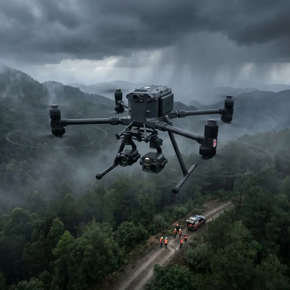
Wind over forested terrain behaves nothing like wind over open fields. Mechanical turbulence created by canopy edges, ridgelines, and valley funneling generates unpredictable gusts that test any aircraft's stabilization systems. The Matrice 400's redundant IMU and GPS modules provide a measurable advantage here, maintaining positional hold within ±0.1 m vertically and ±0.3 m horizontally even in gusty conditions rated up to 12 m/s sustained.
But hardware specs alone don't tell the full story. Operator technique, mission planning, and payload configuration determine whether you return with usable thermal signature data or a hard drive full of blurred frames.
Handling Electromagnetic Interference: The Antenna Adjustment Protocol
During a 2023 wildfire risk assessment over a mixed-conifer stand in British Columbia, my team encountered persistent O3 transmission dropouts at distances beyond 1.8 km. The forest sat on a ridge laced with mineralized granite—a known source of passive EMI. Standard antenna positioning gave us intermittent video feeds and alarming latency spikes.
The fix was methodical. We repositioned the remote controller's antennas to a 45-degree offset angle rather than pointing them directly at the aircraft. This counterintuitive adjustment reduces multipath interference caused by signal reflections bouncing off the canopy surface and mineral-rich terrain below.
After the adjustment, our O3 transmission link stabilized at -75 dBm signal strength out to 3.2 km—well within the margins needed for our BVLOS corridor. The Matrice 400's dual-antenna diversity system actively selects the stronger signal path, but it performs best when the operator gives it geometrically distinct reception angles to work with.
Pro Tip: Before every forest mission, perform a stationary hover at 120 m AGL for 60 seconds while monitoring link quality on DJI Pilot 2. If signal strength dips below -80 dBm, rotate your antenna array in 15-degree increments until you find the strongest reception geometry for that specific site. Log the angle—terrain EMI profiles are consistent between visits.
Key EMI Mitigation Steps
- Orient antennas at 45-degree offset angles in mineralized terrain
- Avoid placing the controller on metal surfaces (vehicle hoods, equipment cases)
- Use a ground station tripod to elevate the controller above waist height
- Monitor O3 transmission signal in real time; abort if sustained below -85 dBm
- Pre-survey the site with an RF spectrum analyzer if repeated missions are planned
Thermal Signature Analysis for Forest Health
The Matrice 400's payload flexibility is where it separates itself from consumer-grade platforms. Mounting a radiometric thermal camera alongside an RGB sensor enables simultaneous capture of thermal signature data and visible-light imagery—essential for detecting early-stage tree stress invisible to the naked eye.
Healthy conifers maintain canopy temperatures 2–4°C below ambient through evapotranspiration. Stressed trees—whether from bark beetle infestation, root disease, or drought—show elevated thermal signatures because their stomata close, reducing transpiration cooling. The Matrice 400's stabilized gimbal holds thermal sensors steady enough to detect temperature differentials as small as 0.5°C across canopy pixels, even in 8–10 m/s crosswinds.
Optimal Thermal Flight Parameters for Forest Canopy
| Parameter | Recommended Setting | Rationale |
|---|---|---|
| Flight altitude (AGL) | 90–120 m | Balances GSD with canopy thermal blending |
| Thermal sensor GSD | ≤13 cm/pixel | Minimum for individual tree crown analysis |
| Overlap (forward/side) | 80% / 70% | Compensates for wind-induced drift |
| Time of day | 10:00–14:00 local | Maximum solar loading for stress contrast |
| Wind limit | 12 m/s sustained | Beyond this, thermal blur degrades accuracy |
| Capture mode | Interval (2s) | Ensures overlap consistency at ground speed |
Thermal data becomes exponentially more valuable when fused with photogrammetry outputs. Overlaying thermal mosaics onto 3D point clouds generated from RGB imagery lets analysts pinpoint stressed individual trees within the structural context of the stand—identifying, for example, whether stress clusters correlate with drainage patterns or exposed ridgelines.
Photogrammetry and GCP Strategy in Forested Terrain
Achieving survey-grade photogrammetry accuracy in forests requires ground control points, and placing GCPs under canopy is one of the most underestimated challenges in drone forestry.
The Matrice 400's RTK module delivers ±1.5 cm horizontal accuracy on its own, but without visible GCPs in the imagery, your photogrammetric bundle adjustment lacks independent verification. For regulatory and scientific credibility, GCPs remain non-negotiable.
GCP Placement Protocol for Forest Sites
- Place a minimum of 5 GCPs per survey block, with 3 on the perimeter and 2 interior
- Use canopy gaps, road clearings, and stream banks for GCP visibility
- Deploy high-contrast checkerboard targets (minimum 60 cm × 60 cm) to ensure detection at 120 m AGL
- Survey each GCP with a GNSS receiver at L1/L2 frequencies for sub-centimeter positioning
- Photograph each GCP placement with a handheld camera for post-processing reference
Expert Insight: In dense boreal forest with >85% canopy closure, traditional GCP placement becomes nearly impossible. In these scenarios, I use a hybrid approach: RTK-corrected camera positions from the Matrice 400 combined with natural feature tie points (exposed boulders, snag tops) surveyed via total station from adjacent clearings. This method consistently achieves <5 cm RMSE without requiring targets under canopy.
BVLOS Operations and Data Security
Many forest monitoring contracts now require BVLOS flight corridors covering linear distances of 5–15 km along fire breaks, transmission lines, or watershed boundaries. The Matrice 400's O3 transmission system supports reliable command-and-control links at ranges that make these missions practical—assuming proper antenna management as discussed above.
Data security matters more than most operators realize. Forest inventory data, endangered species habitat maps, and fire risk models often carry regulatory protections. The Matrice 400 encrypts all downlinked data with AES-256 encryption, ensuring that intercepted transmission data remains unreadable. For agencies operating under environmental data protection mandates, this encryption standard meets or exceeds compliance requirements.
Hot-Swap Batteries: Extending Mission Endurance
Single-battery endurance on the Matrice 400 with a dual-sensor payload runs approximately 28–32 minutes depending on wind load. For a 200-hectare forest block at 80/70 overlap and 100 m AGL, you're looking at roughly 55–65 minutes of total flight time.
Hot-swap batteries eliminate the need to power down, recalibrate sensors, and restart mission plans. The process takes under 45 seconds and maintains gimbal orientation and mission waypoint sequencing. Over a full survey day covering multiple blocks, hot-swap capability saves approximately 90 minutes of cumulative downtime compared to cold-restart workflows.
Matrice 400 vs. Comparable Forest Monitoring Platforms
| Feature | Matrice 400 | Competitor A | Competitor B |
|---|---|---|---|
| Max wind resistance | 12 m/s | 10 m/s | 11 m/s |
| Transmission range | Up to 20 km (O3) | 15 km | 12 km |
| Encryption standard | AES-256 | AES-128 | AES-256 |
| Hot-swap batteries | Yes | No | Yes |
| RTK accuracy | ±1.5 cm | ±2.0 cm | ±1.5 cm |
| Max payload capacity | 2.7 kg | 2.1 kg | 2.4 kg |
| BVLOS readiness | Full compliance kit | Partial | Full compliance kit |
| Gimbal stabilization | 3-axis, ±0.01° | 3-axis, ±0.02° | 3-axis, ±0.01° |
Common Mistakes to Avoid
1. Flying thermal missions at dawn or dusk. Low solar angle means minimal thermal contrast between healthy and stressed trees. Canopy thermal signatures require active solar loading—fly between 10:00 and 14:00.
2. Ignoring terrain-induced turbulence. Wind speed at your launch point may read 6 m/s, but lee-side rotor turbulence behind a ridgeline can generate gusts exceeding 15 m/s. Study topographic maps and set conservative altitude buffers over ridge crests.
3. Using default overlap settings. Factory overlap presets assume calm conditions. Wind-induced ground speed variation means your actual overlap may be 10–15% lower than planned. Increase both forward and side overlap by at least one tier for windy forest flights.
4. Neglecting antenna orientation between sites. The optimal antenna angle at one forest block will not match another site with different terrain mineralogy and canopy density. Re-optimize at every new location.
5. Skipping pre-flight link checks at altitude. Ground-level signal tests don't reveal multipath interference patterns that emerge when the aircraft is above canopy height. Always perform a 120 m AGL hover test before committing to the mission corridor.
Frequently Asked Questions
Can the Matrice 400 fly forest monitoring missions in rain?
The Matrice 400 carries an IP55 ingress protection rating, allowing operation in light to moderate rain. However, water droplets on thermal sensor lenses severely degrade thermal signature accuracy. For thermal missions, avoid rain entirely. For RGB-only photogrammetry flights, light rain is acceptable if you apply a hydrophobic lens coating and verify image sharpness during flight.
How many GCPs do I need for a 500-hectare forest survey?
For a 500-hectare block, deploy a minimum of 8–10 GCPs distributed to cover elevation variation and the full survey extent. Place additional points near terrain transitions (valley floors to ridgelines) where photogrammetric error tends to accumulate. Using the Matrice 400's RTK module reduces but does not eliminate the need for independent ground control.
What is the maximum safe wind speed for canopy-level photogrammetry?
While the Matrice 400 is rated for 12 m/s sustained winds, photogrammetric image quality begins degrading above 9–10 m/s due to platform micro-vibrations affecting pixel sharpness at ground level. For survey-grade deliverables requiring <3 cm GSD, limit flights to conditions below 10 m/s and increase shutter speed to compensate for any residual motion blur.
Ready for your own Matrice 400? Contact our team for expert consultation.