Matrice 400 for Forest Monitoring in Complex Terrain
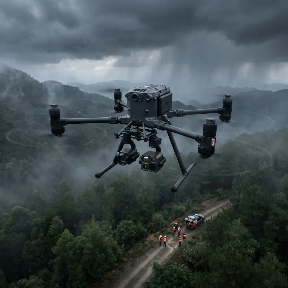
Matrice 400 for Forest Monitoring in Complex Terrain: An Expert Field Method
META: Learn how to configure the Matrice 400 for forest monitoring in steep, signal-challenging terrain, with practical guidance on thermal detection, photogrammetry, antenna management, AES-256 security, and hot-swap battery workflow.
Forest work exposes every weakness in an aircraft, sensor stack, and pilot workflow. Dense canopy blocks line of sight. Ravines distort radio paths. Moisture shifts thermal contrast by the hour. If you are planning to deploy the Matrice 400 in this environment, the real question is not whether it can fly a forest mission. It can. The real question is how to set it up so the data is usable and the operation stays stable when terrain, vegetation, and interference start stacking against you.
That is where the Matrice 400 earns attention. For forestry teams, utilities, conservation groups, and incident managers working in broken terrain, the platform’s value comes from endurance, transmission resilience, payload flexibility, and field practicality. Those strengths only matter, though, if they are translated into a repeatable method.
This guide focuses on that method.
Start with the mission, not the aircraft
Forest monitoring is not one job. It might mean counting storm damage across a slope, identifying heat anomalies after a lightning strike, documenting erosion channels beneath a canopy edge, or building a terrain model for access planning. Each objective changes how the Matrice 400 should be flown.
For example, a thermal search for residual heat in a fire-affected stand demands a different setup than a photogrammetry sortie for a digital surface model. In thermal work, time of day, humidity, and canopy shadow can matter more than flight speed. In mapping work, your overlap, ground sample distance, and control strategy will decide whether the output is analysis-grade or just visually interesting.
The Matrice 400 is useful here because it can support both ends of that spectrum: targeted sensing and structured survey work. That flexibility reduces the need to field different aircraft for adjacent tasks, which is especially valuable in remote forest operations where transport, charging, and crew size are always constraints.
Build around terrain-induced signal problems
Complex terrain does not just complicate route planning. It changes how your link behaves. Ridge lines, metal towers, power infrastructure, and even some temporary field equipment can create electromagnetic interference or multipath reflections that degrade control and video transmission. In forests, pilots often blame trees first. Trees do attenuate signal, especially when wet, but interference and poor antenna orientation are frequently the hidden problem.
This is where disciplined antenna adjustment becomes operationally significant.
With the Matrice 400’s O3 transmission architecture, you have a link designed for robust control and video feedback, but no transmission system performs well if it is pointed badly or shielded by your own position. In practical terms, that means the pilot should treat antenna orientation as a live control input, not a one-time preflight step. If the aircraft is descending into a valley or tracking behind a stand of tall conifers, adjust the controller antenna faces to maintain the strongest practical alignment with the aircraft’s position rather than leaving them fixed at a comfortable angle.
In interference-prone areas, small adjustments matter. Rotate your body. Step laterally away from vehicles, generators, or metal fencing. Reorient the controller before the signal drops, not after. If the mission involves repeated passes along a slope, test link quality from the intended pilot station before launching the full route. A short signal validation hop can save a failed mapping block or an aborted thermal inspection.
This is not theoretical. Forest teams operating near communications sites, high-voltage corridors, or temporary emergency response infrastructure often see transmission quality improve simply by relocating the pilot station a few meters and correcting antenna geometry. On the Matrice 400, that can be the difference between maintaining confident control on a terrain-following leg and losing the video clarity needed to verify a thermal signature.
Use thermal only when the environment helps you
Thermal is one of the most misunderstood tools in forest operations. Many teams assume a thermal payload will cut through canopy and instantly reveal what matters. In reality, forest thermal work depends heavily on exposure, angle, canopy density, and timing.
The Matrice 400 becomes effective in this role when you use thermal for what it does best: identifying contrast, not magically seeing through obstacles. If you are looking for hotspots, stressed vegetation zones, human presence, or wildlife movement at edges and openings, thermal can be extremely efficient. If you are trying to detect something completely concealed under dense canopy at midday, expectations need to be recalibrated.
Operationally, the key term is thermal signature. What you want is a target whose heat profile differs enough from the surrounding environment to survive the clutter created by vegetation, shadow, rock, and changing moisture. Early morning and late evening often create better separation than warm midday conditions. After rainfall, apparent temperature relationships can flatten, which makes weak targets harder to isolate.
On the Matrice 400, the smarter approach is to pair thermal passes with visual confirmation routes instead of relying on one sensor mode to answer the entire question. For post-fire inspection, fly thermal first to identify suspect zones, then run a lower, slower visual or oblique pass to verify the anomaly. For animal tracking near a forest edge, use thermal to narrow the search area, then transition to visual for confirmation and positional logging.
That workflow shortens flight time and improves decision quality. It also keeps crews from over-interpreting ambiguous heat patterns, which is a common failure point in woodland environments.
Photogrammetry in forests needs discipline, not optimism
Photogrammetry over forests is harder than it looks. Canopy texture can be repetitive. Shadows shift rapidly. Wind moves crowns between passes. Understory detail disappears where the canopy closes. If you want useful outputs from the Matrice 400, plan your mapping block with the assumption that the forest will resist clean reconstruction.
This is where GCP discipline matters.
Ground control points are not glamorous, but they remain one of the most effective ways to keep a forest survey anchored to reality. In uneven terrain, relying only on onboard positioning can produce outputs that look clean on screen but drift enough to weaken measurements, change detection, or corridor planning. A modest number of well-distributed GCPs, especially across elevation changes, gives your photogrammetry model a much stronger geometric foundation.
Their operational significance is straightforward: in complex terrain, elevation variation and weak visual tie points can amplify small positioning errors into larger mapping distortions. GCPs help suppress that drift. If your deliverable will guide planting plans, erosion analysis, trail engineering, or habitat boundary work, that accuracy matters.
The Matrice 400’s role here is not simply carrying a camera. It is maintaining stable, repeatable flight over terrain where air movement and signal conditions can quickly degrade consistency. Use high overlap. Resist the urge to stretch one flight too far just to save battery swaps. Break the site into logical blocks with clean margins. If the forest includes steep relief, consider adding oblique imagery along critical slopes or boundaries where nadir-only capture may underrepresent shape.
Photogrammetry in forests rewards methodical crews. The aircraft gives you capacity. The result still depends on field discipline.
Make battery workflow part of your risk management
Longer missions in forest environments are often limited less by aircraft capability than by what happens on the ground between sorties. Rough access roads, narrow clearings, and changing weather compress turnaround time. That is why hot-swap batteries are more than a convenience on the Matrice 400. They are a mission continuity tool.
A hot-swap workflow reduces the dead time between flights, which is especially valuable when you are trying to preserve lighting consistency for photogrammetry or keep a thermal inspection within a narrow environmental window. If morning fog is lifting fast or the sun is starting to flatten temperature contrast, every minute on the ground costs data quality.
The operational significance is simple: faster battery replacement helps keep sequential sorties comparable. That improves mapping consistency and reduces the need to blend data gathered under noticeably different conditions.
In practical terms, build your field routine around battery rotation from the start. Assign one crew member to battery state tracking. Keep landing, payload checks, card management, and relaunch tasks in a fixed order. In forests, fatigue shows up first in routine handling errors, not dramatic piloting mistakes. A clean battery workflow prevents those small errors from accumulating.
Secure the mission data, especially on sensitive sites
Not every forest operation is just ecology. Some involve critical infrastructure corridors, protected habitats, private estates, research plots, or post-incident assessment where location data and imagery carry real sensitivity. The Matrice 400’s AES-256 support matters here because it addresses a practical concern that is often ignored until procurement or compliance teams step in: who can access the data in transit.
For many operators, encryption sounds like an administrative box to tick. In reality, it affects whether certain missions can proceed at all. If you are working near energy assets, restricted zones, or conservation programs with controlled species data, secure transmission can be part of the approval pathway. AES-256 is not a marketing flourish in that context. It is a technical control that supports operational legitimacy.
That matters even more as forest missions move closer to BVLOS frameworks. Once you begin discussing longer corridors, remote observation, or wider-area monitoring beyond the immediate visual bubble, resilience and data security stop being side issues. They become central to how the operation is designed, documented, and approved.
A practical field sequence for the Matrice 400
If I were setting up a Matrice 400 for a forest mission in complex terrain, I would use a sequence like this:
First, define the primary output. Is this thermal detection, surface modeling, change tracking, or incident response? That answer decides the payload setup, time window, and flight geometry.
Second, choose the pilot station based on signal behavior, not just convenience. Before the main sortie, perform a short check flight and watch link quality as the aircraft moves toward likely dead zones. Adjust antenna orientation deliberately. If the area has known interference sources, shift your position and retest before committing to the full route.
Third, design the route around terrain and canopy, not the map’s neatest grid. In steep forest country, a theoretically efficient path can become a weak-data path very quickly. Split missions into sections if needed.
Fourth, if you are mapping, place GCPs where elevation changes and edge conditions are most likely to challenge reconstruction. Do not cluster them where access is easiest and assume software will solve the rest.
Fifth, match thermal collection to environmental timing. Chase contrast, not convenience. A good thermal signature is created by conditions as much as by sensor quality.
Sixth, build in battery turnover discipline so flight blocks remain consistent. Use hot-swap capability to keep the mission tempo steady when timing affects data quality.
Seventh, secure your workflow. If the mission touches sensitive areas or regulated stakeholders, use the available encryption features and document the handling process clearly.
If your team is still refining that field workflow, a quick operational discussion can often prevent expensive trial and error, and it is easy enough to start the conversation here: message our UAV specialists.
Where the Matrice 400 fits best
The Matrice 400 is not interesting because it is new or large or technically dense. It is interesting because it gives experienced crews room to standardize difficult work. Forest monitoring in complex terrain is one of the clearest examples of that. You need stable transmission, flexible sensing, secure data handling, and efficient turnaround in conditions that are rarely forgiving.
The aircraft’s O3 transmission capability matters because forests and ridgelines punish weak link management. AES-256 matters because many environmental and infrastructure-adjacent missions now require stronger data protection. Hot-swap batteries matter because environmental conditions do not pause while your team waits on the ground. And if your objective includes thermal assessment or photogrammetry, success still depends on when and how you fly, not just what aircraft you bought.
That is the right way to think about the Matrice 400 for forestry work. Not as a shortcut, and not as a universal answer. As a platform that performs best when paired with disciplined route design, careful antenna handling, accurate ground control, and realistic sensor expectations.
Get those pieces right, and the aircraft becomes more than capable. It becomes dependable, which is what field teams actually need.
Ready for your own Matrice 400? Contact our team for expert consultation.