Matrice 400 in Remote Forest Monitoring: What Actually
Matrice 400 in Remote Forest Monitoring: What Actually Matters in the Field
META: A field-focused Matrice 400 case study for remote forest monitoring, covering antenna positioning, transmission reliability, thermal workflows, photogrammetry discipline, and why engineering standards still matter.
Remote forest monitoring is where drone specifications stop being marketing material and start becoming operational constraints.
A Matrice 400 deployed over dense canopy has to do several things well at once. It needs to keep a stable link when the aircraft is far from the pilot, hold enough endurance to cover meaningful acreage, support thermal and visual payload workflows in the same mission set, and produce data that stands up after the flight when the forestry team is making decisions about disease spread, heat anomalies, storm damage, drainage patterns, or replanting progress. In this environment, small technical choices have outsized consequences.
I’ve seen crews focus heavily on airframe endurance while underestimating two quieter factors: signal discipline and data discipline. The first determines whether the aircraft can safely and consistently work at distance. The second determines whether the imagery is useful once it reaches the GIS or asset management team. For a Matrice 400 operation in remote woodland, both are decisive.
A forest monitoring case that reveals the real priorities
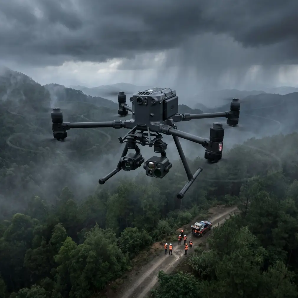
Consider a typical assignment: a forestry contractor is asked to assess a remote section of mixed woodland after a period of heat stress and localized storm activity. The brief sounds simple enough. Identify canopy gaps, check for drainage disruption, scan for thermal irregularities that could indicate smoldering organic material or unhealthy vegetation clusters, and build a current map layer for comparison against previous orthomosaics.
This is exactly the sort of job where the Matrice 400 starts to make sense. A platform designed for professional inspection and mapping can carry the right sensing stack, maintain a robust downlink, and support repeated deployments in terrain that is unfriendly to ordinary drone operations. But the aircraft alone does not solve the mission.
Remote forests are difficult because they combine distance, elevation changes, inconsistent takeoff zones, multipath interference from terrain edges, and long tree lines that can quickly degrade line quality if the pilot station is poorly positioned. Add humid air, temperature inversions in the early morning, and the need to toggle between thermal signature review and photogrammetry capture, and the mission gets more technical than many teams expect.
Antenna positioning advice for maximum range
If there is one habit I would drill into every Matrice 400 crew working in forests, it is this: treat antenna positioning as part of flight planning, not as an afterthought once the aircraft is already in the air.
The practical rule is simple. Set up where the controller has the cleanest possible view into the aircraft’s intended operating volume, not merely where parking is convenient. In forest monitoring, that often means walking a short distance to a ridge shoulder, cleared service track, or edge opening that gives the ground station more sky exposure above the treeline. Even an excellent transmission system is still bound by geometry.
With O3 transmission in play, crews often assume the link margin will rescue poor setup decisions. Sometimes it does. Often it doesn’t. In remote canopy work, the best results usually come when the antennas are oriented broadside toward the aircraft’s operating sector rather than pointed directly at it like a flashlight. Many operators instinctively “aim” the controller tips at the drone. That is commonly the wrong move. The strongest radiation pattern is usually off the sides of the antenna faces, so the pilot should present the effective antenna surface toward the aircraft’s path and make small adjustments as the mission sector shifts.
The second piece is elevation relationship. If the aircraft is going to spend most of the mission beyond a treeline crest or dropping into a shallow basin, launch from the side that preserves the cleanest signal path for the majority of the route. A 30-second relocation before takeoff can save a broken mission later.
The third piece is human discipline. Keep the ground station operator from drifting behind vehicles, under metal awnings, or beside utility structures that can distort the link. In open-country forestry jobs, these mistakes are common because teams get comfortable once the aircraft is stable. Transmission quality is rarely ruined by a single dramatic failure. More often it is degraded by a string of casual decisions.
Why standards from older aviation references still matter to a modern UAV team
This might sound unexpected in a Matrice 400 article, but one of the most useful lessons for remote forest operations comes from older aircraft design references on documentation and materials.
One source notes that electrical technical drawing standards were revised in China during 1986 to 1987 under CB/T6988.1-6, aligned with IEC-based electrical documentation systems. It also points out that symbol systems evolved from older IEC117 references to IEC617 and later to IEC60617, while document preparation standards shifted from IEC1082 to IEC61082. Another detail stands out: symbols were drawn on an M = 2.5 mm standard grid system, while some CAD ecosystems continued using inch-based conventions derived from American standards such as ANSI Y32.2/IEEE STD.315.
That may seem distant from a drone in a forest, but the operational significance is immediate. Modern Matrice 400 programs live or die on documentation consistency: payload wiring notes, charging procedures, field maintenance diagrams, network layouts, relay station sketches, and sensor integration records. If your remote operations span multiple teams, mixed software environments, or multilingual documentation, symbol confusion and unit inconsistency create avoidable downtime. A forest monitoring mission may depend on a thermal payload, RTK accessories, battery rotation systems, portable charging, and encrypted data transfer. If one technician is working in inch-based drafting logic while another team maintains metric documentation, simple wiring and mounting misunderstandings multiply.
The old standardization lesson still applies: common symbols, common formatting, common units. That is not bureaucracy. That is what lets a field team replace a damaged component, validate a harness, or confirm an integration change without improvising in the rain at the edge of a forest road.
Thermal signature work is only as good as your mission timing
A lot of Matrice 400 buyers are interested in thermal signature detection for forestry, but thermal success is less about owning a capable platform and more about when and how the platform is deployed.
For canopy health review, drainage detection, and hotspot screening, early morning and late evening windows often provide cleaner thermal separation than midday. Dense forests can flatten thermal contrast once solar loading becomes uneven across different species and terrain slopes. The aircraft may still capture usable imagery, but interpretation gets harder. With the Matrice 400, the better approach is to define your thermal question before launch.
Are you trying to locate residual heat in organic ground layers near access tracks? Are you comparing tree stress zones? Are you searching for unauthorized campfire remnants in a conservation area? Each of those requires different altitude, speed, overlap, and angle decisions. Thermal imagery gathered without a target question usually ends up as interesting video rather than operational evidence.
This is where secure workflow matters too. If your team is moving sensitive environmental data across subcontractors or conservation stakeholders, AES-256 support becomes more than a line item. It helps ensure that location-tagged imagery, thermal findings, and mapping outputs are not casually exposed in transit. For utilities, forestry concessions, and ecological survey work, this can be a compliance and trust issue as much as a technical one.
Photogrammetry in forests: slower thinking, better outputs
Photogrammetry in woodland conditions is rarely forgiving. The temptation is to fly broad, fast grids and expect software to sort everything out. Under canopy edge conditions and mixed-height vegetation, that approach tends to produce gaps, poor tie points, and weak surface interpretation.
The better Matrice 400 workflow is to accept that forest mapping is a controlled data acquisition exercise. GCP placement should be planned around access reality, not theoretical perfect spacing. In remote terrain, fewer well-verified ground control points often outperform a larger set of casually placed markers. If the mission goal is comparative monitoring over time, consistent GCP logic matters more than chasing ideal geometry that the site cannot support.
Altitude selection also deserves restraint. Too high, and the canopy becomes visually homogeneous. Too low, and mission efficiency collapses while parallax complications increase around treetops and uneven clearings. Forestry crews should define whether they are mapping canopy extent, road and drainage infrastructure, stormfall distribution, or regeneration zones. Each objective favors different image geometry.
The Matrice 400 is well suited to this kind of repeatable capture because it is built for serious operational cadence. That matters in remote work, where a failed battery swap or a rushed restart can waste a narrow weather window. Hot-swap batteries are especially valuable here. In a forest staging area, that means the aircraft can return, rotate power, and get back to work with minimal interruption to mission continuity. The significance is not convenience alone. It reduces the chance that lighting conditions, thermal conditions, or wind patterns shift dramatically between sorties. For longitudinal environmental monitoring, that consistency has real analytical value.
Materials science has something to teach drone operators too
The second source reference, on aircraft adhesives and BSC core components, looks even less connected at first glance. Yet it contains a useful operational lesson for anyone trusting a Matrice 400 in demanding field environments.
The reference compares typical bending shear strength and shear modulus values for BSC core elements using different panel adhesives, including SY-14 and J-30. One figure listed is 0.933 for a 65 / 0.05/3 configuration in the SY-14 table, while related modulus data for SY-14 reaches 0.245 in another row. J-30 entries show different behavior again, such as 0.431 and 0.617 in the strength table for lighter configurations.
The point is not to turn a drone crew into adhesive engineers. The point is that material interfaces govern durability. In aviation systems, bond choices affect how structures resist flex, vibration, and load transfer over time. For UAV operators in remote forests, that principle translates directly into payload mounting discipline, inspection routines, and environmental exposure management. A heavy-lift platform operating from rough field setups sees vibration, repeated thermal cycling, moisture exposure, and handling stress. If crews treat mounting interfaces, accessories, or third-party modifications casually, they are inviting the same class of failure that material engineers work hard to prevent.
So yes, a forestry team should absolutely care about preflight inspection of mounts, dampers, connector security, and any bonded or composite accessories. Not because a handbook page says so, but because remote operations punish weak interfaces. A component that survives ten easy launches near the office may fail on the eleventh sortie after a cold morning setup, a rough case transfer, and an uneven takeoff pad in the field.
BVLOS planning starts on the ground, not in the software
Where local regulations and approvals support BVLOS operations, the Matrice 400 becomes especially relevant for remote environmental coverage. But operators should resist the idea that BVLOS is mainly a software checkbox or permissions exercise.
In forests, BVLOS quality depends on route architecture, terrain awareness, communication discipline, and emergency logic that has been thought through before the first launch. A crew should know where signal quality may fade, where visual terrain references disappear, where alternate recovery zones exist, and how battery transitions line up with route segments. Transmission security and range capability are enablers, not substitutes for planning.
This is one reason I advise forestry teams to build a mission sheet that combines mapping intent, antenna orientation notes, likely signal shadow zones, battery rotation order, weather observations, and payload-specific settings. It sounds basic. It is not. The teams that do this consistently are usually the ones producing repeatable, defensible datasets.
If you are setting up a remote monitoring workflow and want a practical second opinion on link strategy or payload configuration, send the mission outline here: message James directly on WhatsApp.
What a well-run Matrice 400 forest mission looks like
A strong remote forest operation with the Matrice 400 is not defined by flashy flight footage. It looks quieter than that.
The launch site is chosen for RF geometry, not convenience. Antennas are positioned correctly from the first takeoff. Thermal missions are timed for interpretable contrast rather than fitted into the middle of a broad survey day. Photogrammetry settings are built around canopy behavior, with GCP strategy matched to what field teams can realistically maintain over time. Battery swaps are organized to preserve environmental consistency between sorties. Data movement is secured. Documentation is standardized so the airframe, payload, and support kit remain understandable across technicians and seasons.
That is the difference between owning a capable drone and running a capable program.
The Matrice 400 has obvious appeal for remote forest monitoring because it can support long-range data capture, serious sensor workflows, and professional operational tempo. Yet the deeper advantage shows up only when teams pair the aircraft with disciplined fieldcraft. Older engineering references, whether they are discussing a 2.5 mm symbol grid for standardized electrical documentation or comparative adhesive behavior in core structures, point back to the same truth: reliability is built long before the mission reaches the tree line.
Ready for your own Matrice 400? Contact our team for expert consultation.