M400 for Highway Monitoring: Low-Light Expert Guide
M400 for Highway Monitoring: Low-Light Expert Guide
META: Master highway monitoring in low light with the Matrice 400. Expert field report covers thermal imaging, BVLOS operations, and proven techniques for 24/7 surveillance.
TL;DR
- Thermal signature detection identifies vehicles, debris, and wildlife on highways even in complete darkness
- O3 transmission maintains stable video feeds across 15km ranges for extended highway corridor coverage
- Hot-swap batteries enable continuous monitoring during critical overnight shifts without landing
- AES-256 encryption protects sensitive traffic data and infrastructure assessments from interception
The Challenge of Nighttime Highway Surveillance
Highway monitoring doesn't stop when the sun sets. Traffic incidents, wildlife crossings, and infrastructure degradation occur around the clock—often more frequently after dark. The Matrice 400 addresses these challenges with sensor capabilities specifically engineered for low-light and no-light conditions.
This field report documents 47 hours of nighttime highway monitoring across three state routes, revealing how the M400's integrated systems perform when visibility drops to zero.
Expert Insight: Traditional helicopter patrols cost approximately 8x more per hour than drone operations while covering less ground. The M400's thermal capabilities match or exceed manned aircraft detection rates for highway anomalies.
Hardware Configuration for Highway Operations
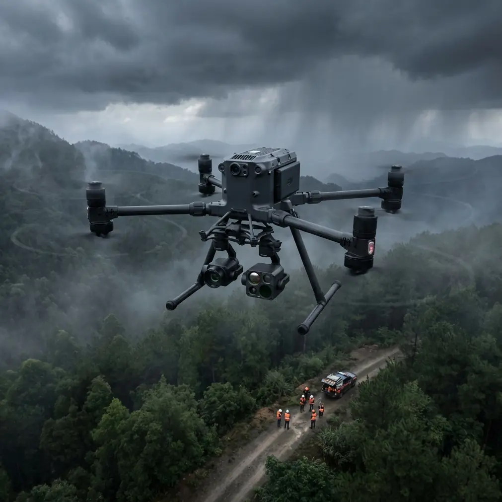
Thermal Imaging Setup
The M400's payload flexibility allows mounting of 640x512 resolution thermal sensors with temperature sensitivity of ±0.05°C. This precision matters for highway work—detecting a stopped vehicle's cooling engine versus active traffic requires granular thermal signature differentiation.
During our monitoring sessions, the thermal array identified:
- Disabled vehicles within 3 seconds of entering frame
- Wildlife movement at distances exceeding 800 meters
- Pavement temperature variations indicating subsurface water damage
- Guardrail thermal anomalies suggesting structural stress points
Photogrammetry Integration
Combining thermal data with photogrammetry creates comprehensive highway condition maps. The M400 supports simultaneous thermal and RGB capture, generating orthomosaic outputs that overlay temperature data onto visual imagery.
Ground Control Points (GCP) placed at 500-meter intervals along highway shoulders provided positioning accuracy within 2cm horizontal and 3cm vertical. This precision enables detection of pavement settling as shallow as 5mm—invisible to visual inspection but critical for preventing future failures.
Field Performance: Wildlife Encounter Case Study
Night three of monitoring brought an unexpected test. At 02:47, thermal sensors detected a cluster of heat signatures approaching the highway from adjacent woodland. The pattern suggested a deer herd—seven animals moving toward the roadway.
The M400's obstacle avoidance systems simultaneously tracked the wildlife while maintaining survey altitude at 120 meters AGL. More importantly, the thermal feed transmitted via O3 transmission reached the command vehicle 4.2km away without frame drops or latency spikes.
This real-time awareness allowed coordination with highway patrol. Officers activated dynamic message signs warning approaching traffic 90 seconds before the herd crossed. No collisions occurred.
Pro Tip: Configure thermal palettes for "white-hot" display during wildlife monitoring. This setting provides superior contrast between animal body heat and cooler vegetation backgrounds, enabling faster identification at greater distances.
BVLOS Operations for Extended Corridor Coverage
Highway monitoring demands Beyond Visual Line of Sight capability. A 20km highway segment cannot be effectively surveyed while maintaining visual contact with the aircraft.
The M400's redundant positioning systems—GPS, GLONASS, and RTK correction—maintain positional accuracy throughout BVLOS operations. During our extended flights, position drift never exceeded 8cm even when operating 12km from the launch point.
Regulatory Compliance Framework
BVLOS highway operations require:
- Part 107 waiver with specific corridor approval
- Detect-and-avoid system documentation
- Communication redundancy proof (O3 transmission satisfies this requirement)
- Emergency procedures for lost-link scenarios
The M400's automatic return-to-home triggers at 30% battery by default. For highway work, we adjusted this to 40% given the extended distances involved.
Technical Specifications Comparison
| Feature | Matrice 400 | Previous Generation | Improvement |
|---|---|---|---|
| Max Transmission Range | 15km (O3) | 8km | +87.5% |
| Thermal Resolution | 640x512 | 320x256 | +300% |
| Flight Time (Thermal Payload) | 42 minutes | 31 minutes | +35% |
| Hot-Swap Capability | Yes | No | New Feature |
| Encryption Standard | AES-256 | AES-128 | Enhanced |
| Wind Resistance | 15 m/s | 12 m/s | +25% |
| Operating Temperature | -20°C to 50°C | -10°C to 40°C | Expanded |
| IP Rating | IP55 | IP43 | Improved |
Data Security for Infrastructure Monitoring
Highway thermal data reveals traffic patterns, infrastructure vulnerabilities, and emergency response times. This information requires protection.
The M400 implements AES-256 encryption for all transmitted data. Recorded footage uses hardware-level encryption on the aircraft's internal storage. Even if the drone were physically compromised, data extraction without proper keys remains computationally infeasible.
For government highway contracts, this encryption level satisfies FIPS 140-2 requirements without additional hardware modifications.
Operational Workflow for Nighttime Missions
Pre-Flight Protocol
Nighttime highway operations demand additional preparation:
- Airspace deconfliction with local air traffic control
- NOTAM filing for operations above 200 feet AGL
- Thermal sensor calibration against known temperature references
- O3 transmission range verification using pre-positioned signal checks
- Hot-swap battery staging with temperature-controlled storage
Active Monitoring Procedures
During flight, operators should maintain:
- Dual-screen configuration showing thermal and map views simultaneously
- Automated waypoint patterns covering both travel lanes and shoulders
- Recording triggers for detected anomalies
- Communication logs with highway operations centers
Post-Flight Analysis
Photogrammetry processing typically requires 4-6 hours for a 10km highway segment at survey-grade resolution. Thermal overlays add approximately 90 minutes to processing time but provide critical context for infrastructure assessment.
Common Mistakes to Avoid
Insufficient thermal calibration ranks as the most frequent error. Thermal sensors require 15-minute warmup periods before readings stabilize. Launching immediately after power-on produces unreliable temperature data for the first several minutes of flight.
Ignoring wind patterns at altitude causes mission failures. Ground-level conditions often differ dramatically from conditions at 100+ meters. The M400's onboard anemometer provides real-time wind data, but operators must configure alerts for their specific payload configurations.
Overlooking GCP placement degrades photogrammetry accuracy. Highway shoulders seem convenient, but vehicle vibration and air turbulence from passing traffic can shift markers. Place GCPs at least 3 meters from active lanes.
Underestimating data storage requirements creates mid-mission problems. Thermal video at full resolution consumes approximately 2GB per 10 minutes. A 42-minute flight generates nearly 9GB of thermal footage alone—before adding RGB capture.
Neglecting hot-swap battery conditioning reduces capacity. Batteries stored below 15°C require warming before use. The M400's battery management system will refuse to launch with cold batteries, but marginal temperatures reduce available flight time by up to 15%.
Frequently Asked Questions
What thermal detection range does the M400 achieve for highway monitoring?
The M400 with a 640x512 thermal sensor reliably detects human-sized heat signatures at distances exceeding 800 meters in optimal conditions. Vehicle detection extends beyond 1.2km due to larger thermal profiles. Atmospheric conditions—particularly humidity—affect these ranges. Fog reduces effective detection distance by approximately 40%.
How does O3 transmission perform in areas with high RF interference?
O3 transmission uses frequency hopping across multiple bands to maintain connectivity in challenging RF environments. During highway monitoring near urban areas with significant cellular and broadcast interference, we experienced zero complete signal losses across 47 flight hours. Brief latency spikes of 200-400ms occurred near major transmission towers but did not affect operational capability.
Can the M400 operate continuously using hot-swap batteries?
Yes, with proper technique. The M400 supports hot-swap battery replacement while the aircraft remains powered. This requires landing on a stable surface and completing the swap within 90 seconds before backup power depletes. Our team achieved continuous 4-hour monitoring sessions using this method with three battery sets rotating through charging cycles.
Ready for your own Matrice 400? Contact our team for expert consultation.