Matrice 400 for Remote Highway Monitoring
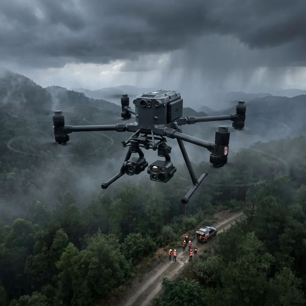
Matrice 400 for Remote Highway Monitoring: What Actually Matters in the Field
META: A practical expert guide to using the Matrice 400 for remote highway monitoring, covering thermal workflows, photogrammetry, O3 transmission, AES-256 security, hot-swap batteries, and BVLOS planning.
Remote highway monitoring sounds straightforward until you are the one responsible for keeping eyes on dozens of kilometers of pavement, bridges, embankments, drainage channels, and traffic-impact risks far from the nearest operations base.
That is where the Matrice 400 starts to make sense.
Not because it is simply a large enterprise drone, and not because every inspection task needs maximum aircraft. It makes sense because remote road corridors create a very specific operational problem: long linear coverage, patchy access, shifting weather, limited landing options, and a constant need to move between visual checks, thermal interpretation, and mapping-grade data capture without wasting time on the shoulder of a road.
I have worked around enough corridor inspections to know that the aircraft itself is only half the story. The other half is whether the drone supports a field workflow that remains stable after the third battery cycle, when wind picks up, the signal path changes behind terrain, and the team still has 18 kilometers left to assess before daylight fades.
For that kind of work, the Matrice 400 should be judged less by brochure language and more by how it handles four pressure points: transmission reliability, payload flexibility, battery turnover, and data security.
The real problem in remote highway monitoring
A highway in a remote area is not one asset. It is a chain of different assets with different failure signatures.
One section may need photogrammetry to document shoulder erosion or quantify slope movement. A bridge deck may need a close visual pass. A culvert or overheated electrical cabinet at a roadside installation may call for thermal signature analysis. After rain, drainage failures may only become obvious when you compare geometry, moisture patterns, and heat retention across a corridor.
Trying to cover all of that with a narrow drone setup creates bottlenecks. Teams either fly too many separate missions, or they collect the wrong kind of data on the first pass and have to return later.
The Matrice 400 is better understood as a platform for compressing those decisions into one coordinated field operation.
Why transmission quality matters more than people admit
On remote highways, signal confidence is operational confidence.
You may be launching from a gravel turnout, then following a road alignment that dips behind low terrain, vegetation, utility structures, or bridge approaches. A drone can have excellent flight performance and still lose practical value if the video and telemetry link becomes inconsistent when the aircraft moves into the corridor.
That is why O3 transmission is not a throwaway specification. In this context, it affects whether the pilot and payload operator can keep making accurate decisions in real time. A stable link means cleaner framing for defect detection, fewer interruptions when coordinating waypoint changes, and more trust when monitoring a mission that stretches along a linear asset instead of circling one fixed site.
For remote highway work, that matters in two ways.
First, it improves detection quality. If your visual feed is unstable, subtle issues get missed. Cracking along concrete drainage structures, early edge breakup, missing signage, washout around barriers, or thermal anomalies in roadside equipment often appear as small clues before they become obvious failures.
Second, it supports safer BVLOS-style planning where regulations and operating approvals allow it. I am not talking about treating long-range work casually. The point is that robust transmission is part of what makes properly planned extended corridor observation feasible in a commercial setting. If the mission design includes remote observers, defined emergency procedures, and approved operating methods, a stronger link can reduce friction across the whole workflow.
Payload flexibility is what makes the aircraft practical
A remote highway mission rarely stays inside one sensor category.
This is where the Matrice 400 earns its keep. A platform in this class is valuable because it can support the sort of payload options that let a team move from visual situational awareness to thermal interpretation to survey-grade capture without rebuilding the entire operation around a second drone.
That flexibility matters most when conditions change mid-mission.
Say your original task is a photogrammetry run over a section where drainage damage is suspected. You establish GCP positions where needed for tighter absolute accuracy, collect overlap for surface reconstruction, and begin building a corridor model. Halfway through the day, the road authority asks for a look at a recurring heat issue around a remote roadside power enclosure and a check on a bridge bearing area where water intrusion is suspected.
A less capable workflow turns that into a scheduling problem. The Matrice 400 turns it into a payload and mission-planning problem, which is much easier to solve in the field.
Thermal signature work is especially useful on remote highways because some failure patterns hide in plain sight under standard RGB viewing. Moisture retention, delamination tendencies, overheating components in roadside systems, and inconsistent drainage behavior can all show up more clearly when thermal data is interpreted correctly. Thermal is not magic, and it does not replace engineering judgment, but it can narrow down where crews need to investigate first.
Photogrammetry serves a different purpose. It gives infrastructure teams a measurable record. With the right flight geometry, overlap, and GCP strategy, you are not just taking pictures of a problem. You are building a dataset that can be revisited, compared over time, and used to quantify movement, volume loss, or construction progress.
That combination—thermal for anomaly detection, photogrammetry for measurable documentation—is one of the strongest arguments for using a Matrice 400-class platform on long, remote transport corridors.
A field tip that saves more time than any headline feature
Battery management on long road inspections is where good days are preserved or ruined.
The obvious point is that hot-swap batteries keep the operation moving. The less obvious point is how you use that advantage. Too many crews treat battery replacement as a race. They land, swap, relaunch, and only then remember that ambient temperature has shifted, wind has changed direction, and the next route segment climbs slightly with the terrain.
My rule in the field is simple: use every hot-swap as a decision point, not just a power reset.
On the Matrice 400, hot-swap capability is valuable because it reduces downtime between sorties. But the real gain comes from pairing that with disciplined battery rotation and mission segmentation. I prefer to divide a remote highway route into logical blocks based on terrain, access points, and recovery options rather than trying to maximize every single sortie. If one battery set consistently returns warmer after a high-wind leg, I flag it for the less demanding segment next cycle instead of blindly putting it back into the longest run.
That sounds minor. It is not.
Across a full day, this habit improves power predictability, helps maintain safer reserve margins, and reduces the temptation to stretch one more kilometer because the aircraft “should” still have enough. In remote operations, the smartest battery strategy is not getting the longest flight on paper. It is ensuring each launch begins with a realistic energy profile for the terrain and task directly ahead.
Security is not a background issue on infrastructure missions
Road monitoring teams are often collecting sensitive civil infrastructure data: bridge imagery, utility connections, access routes, construction staging areas, and high-resolution terrain models. Even when the mission is entirely civilian, the data itself deserves protection.
That is why AES-256 matters.
For many readers, encryption sounds like a line item for IT staff. In reality, it has operational significance in the field because it supports a more secure handling chain for video transmission and mission data associated with critical infrastructure inspection. If your workflow involves contractors, engineering consultants, public agencies, and cloud processing environments, every layer of confidence helps.
I would not choose an aircraft on encryption alone. I would absolutely factor it into any platform decision for highway authorities, EPC teams, or corridor maintenance contractors that need defensible data governance.
Building a better highway workflow around the Matrice 400
A smart remote monitoring program does not just ask, “How far can the drone go?” It asks, “What can one field team complete accurately in one deployment window?”
With the Matrice 400, a productive highway workflow often looks like this:
- Pre-identify inspection priorities by corridor segment: pavement distress, slope stability, drainage behavior, bridge components, roadside systems.
- Assign the right capture mode to each segment rather than forcing one flight profile across the whole route.
- Use photogrammetry where measurable terrain or structural change is the priority, and bring GCPs into the plan when absolute positioning needs to stand up to engineering review.
- Use thermal selectively, at the right time of day, when surface heating patterns and equipment temperatures are most likely to reveal meaningful contrast.
- Segment sorties around realistic recovery and access points, not just battery theory.
- Treat transmission quality and data security as mission enablers, not afterthoughts.
That last point separates polished operators from crews that are simply flying advanced equipment.
Where the Matrice 400 fits best
The Matrice 400 is not overkill when the mission combines distance, mixed sensor needs, and the need for repeatable outputs. It is a strong fit for:
- remote highway condition assessments
- bridge and overpass observation
- embankment and slope monitoring
- drainage and washout identification
- construction progress along road corridors
- thermal review of roadside electrical or mechanical assets
- repeat mapping missions for change detection
The aircraft is particularly useful when the same team needs to shift between immediate operational awareness and engineering-grade documentation without returning to base to reconfigure the entire job.
That is the part many people miss. The platform’s value is not just in raw capability. It is in reducing the number of weak links between the first launch and the final deliverable.
A realistic note on BVLOS and remote operations
BVLOS gets mentioned in almost every corridor-drone conversation for a reason: highways are linear, and linear assets invite longer mission profiles. But extended operations only become useful when they are wrapped in proper planning, approvals, crew structure, and emergency procedures.
The Matrice 400 supports that kind of serious commercial thinking better than smaller ad hoc setups because its transmission, payload architecture, and operational design are aligned with sustained fieldwork. That does not make planning optional. It makes disciplined planning worthwhile.
If your remote corridor program is maturing and you need to discuss a practical setup, mission design, or payload mix, you can start the conversation here: https://wa.me/85255379740
The bottom line for remote highway teams
For remote highway monitoring, the Matrice 400 should be evaluated as a workflow platform rather than a flying camera.
O3 transmission matters because corridor missions live or die by link stability. AES-256 matters because infrastructure data needs protection. Hot-swap batteries matter because remote operations depend on efficient, controlled turnaround. Thermal signature tools matter because some defects are easier to prioritize when heat patterns are visible. Photogrammetry with a sound GCP strategy matters because agencies and contractors need measurable, repeatable outputs, not just imagery.
Put all of that together, and the Matrice 400 becomes a practical answer to a very specific challenge: how to inspect long, remote road infrastructure with fewer compromises between speed, accuracy, and operational control.
That is its real value in the field.
Ready for your own Matrice 400? Contact our team for expert consultation.