Monitoring High-Altitude Power Lines With the Matrice 400
Monitoring High-Altitude Power Lines With the Matrice 400: A Field Tutorial From the Mountain Corridor
META: Expert tutorial on using the Matrice 400 for high-altitude power line inspection, covering thermal signature analysis, photogrammetry, BVLOS planning, O3 transmission, AES-256 security, and hot-swap battery workflow.
High-altitude transmission inspection is unforgiving work. Thin air changes aircraft behavior. Ridge lift and crosswinds distort flight paths. Snow glare hides defects that would stand out instantly at lower elevations. And when the line corridor cuts through forest, rock faces, and wildlife habitat, the mission stops being a simple visual check and becomes an exercise in disciplined data capture.
That is where the Matrice 400 becomes genuinely useful.
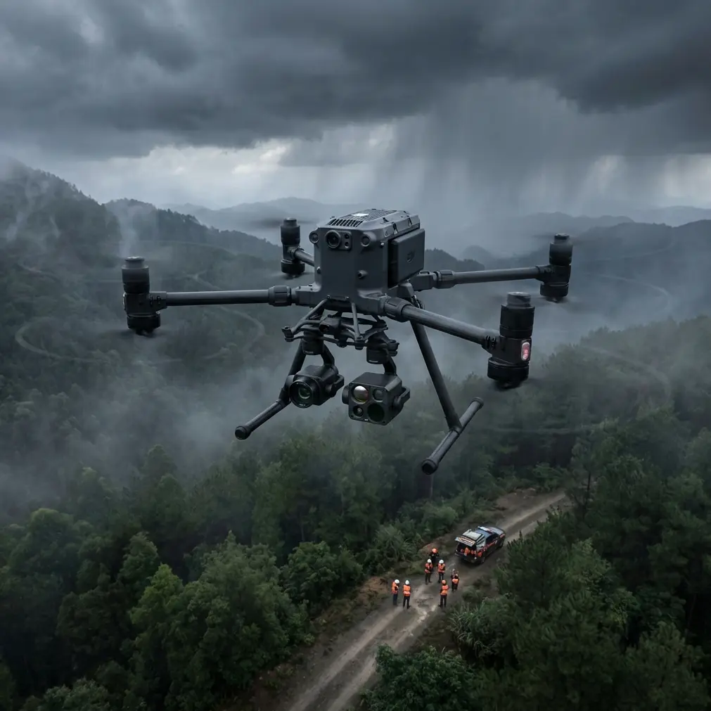
I am not talking about the aircraft as a brochure object. I mean the Matrice 400 as a working platform for power utilities that need repeatable inspection results on steep terrain, where every sortie has to return more than pretty imagery. If your job is monitoring power lines in high altitude, the value of the M400 is not just lift capacity or endurance in isolation. It is the way the platform supports a full inspection chain: secure mission planning, stable transmission, thermal anomaly detection, photogrammetric reconstruction, and battery handling that does not waste a weather window.
This tutorial walks through how I would structure a real M400 mission for mountainous power-line inspection, including one field complication many teams underestimate: wildlife in the corridor. On one survey, a pair of Himalayan griffon vultures rose from a cliff shelf just below conductor height and crossed our planned observation arc. The drone’s sensor suite and disciplined standoff workflow mattered more in that moment than raw aircraft performance. We paused the close pass, widened the orbit, held visual awareness, and resumed only after the birds cleared the area. That is not a side story. It is part of what high-altitude utility work actually looks like.
Why the Matrice 400 fits this mission profile
The Matrice 400 is well suited to high-altitude line inspection because this job demands more than one sensing mode at a time. A utility team usually needs three layers of evidence from the same corridor:
- A visual record of towers, insulators, conductors, spacers, and hardware
- A thermal signature set that helps identify abnormal heating
- A photogrammetric dataset that supports geometry checks, vegetation encroachment review, and location-anchored reporting
A platform in this class matters because line inspection in the mountains often requires carrying a serious payload stack while preserving enough stability to keep the data usable. In practical terms, that means you are not just trying to “see the line.” You are trying to document fault indicators precisely enough that a maintenance planner can decide whether the issue is urgent, seasonal, or suitable for the next outage cycle.
The M400 also aligns with the communications and security expectations that utilities increasingly impose. If your inspection data includes critical infrastructure imagery, secure transmission is not optional. O3 transmission helps maintain command and video link stability across uneven terrain, while AES-256 encryption addresses a separate but equally important requirement: protecting the telemetry and image path from unnecessary exposure. In mountain corridors, those are not abstract features. Terrain masking is real, and infrastructure operators do ask pointed questions about data security.
Step 1: Build the mission around altitude, not around distance
Many crews new to alpine utility work plan from map distance first. That is a mistake. In high-altitude inspection, altitude is the primary constraint because it affects rotor efficiency, battery behavior, and reserve margins. The same route that feels routine at lower elevations can become a much tighter operation when the launch point is already far above sea level.
With the Matrice 400, I recommend designing the mission in sections rather than as one continuous line run. Break the corridor into tower groups or terrain-defined segments. A saddle, a ridge shoulder, and a canyon bend should each be treated as separate flight environments even if they are adjacent on the map.
For each segment, define:
- Launch and recovery points with clear escape routes
- Maximum standoff distance from the line
- Alternate observation positions in case wind direction shifts
- A thermal pass and a visual detail pass
- Battery swap timing before reserves become uncomfortable
This segmented logic matters because mountain weather changes faster than utility planners like to admit. A corridor can be calm on the south-facing slope and turbulent 400 meters later at the ridge break. The M400 gives you a strong operating base, but good inspection results still come from conservative mission architecture.
Step 2: Use thermal signature data intelligently
Thermal inspection is often treated as a quick add-on. It should not be. In high-altitude environments, temperature contrast can be deceptive. Cold ambient air may make some faults appear more distinct, but solar loading, wind cooling, and reflective backgrounds can also distort interpretation.
On the Matrice 400, thermal work should be flown with consistency rather than speed. Keep your observation geometry repeatable. If one insulator string is recorded obliquely and the next nearly head-on, your comparative review becomes weaker. The goal is to create a dataset where hotspot suspicion is based on pattern, not on camera angle luck.
What are you looking for?
- Connector points with localized heat elevation
- Clamp assemblies showing unexpected thermal spread
- Insulator regions with irregular heating compared with adjacent units
- Equipment at structure tops where heat does not match the surrounding hardware baseline
Thermal signature analysis becomes much more useful when paired with visual context from the same waypoint family. If the thermal image suggests an issue at a dead-end assembly, the visible image should make component identification easy for the asset team. The M400’s value in this workflow is not simply carrying a thermal sensor. It is supporting enough flight stability and transmission quality that your thermal pass remains deliberate even in thinner air and changing winds.
Step 3: Pair inspection with photogrammetry, not just screenshots
Utilities increasingly want more than defect photos. They want measurable context. This is where photogrammetry becomes operationally significant.
For a high-altitude power line mission, photogrammetry lets you build a spatial record of towers, conductor clearances, surrounding terrain, and vegetation encroachment patterns. If a line segment repeatedly suffers from icing, wind interaction, or slope movement nearby, a structured 3D model can reveal patterns that isolated inspection images never will.
To make the M400 useful for photogrammetry in this setting, plan for overlap discipline and control accuracy. If your corridor is accessible enough, introduce GCPs at strategic ground locations near key structures or maintenance roads. Even a modest set of well-surveyed GCPs can materially improve model alignment and reporting confidence. That matters when the engineering team needs to compare seasonal shifts or validate whether a suspected terrain movement is affecting tower geometry.
At high altitude, crews often want to skip GCP placement because access is difficult. Sometimes that is justified. But where practical, GCP-supported models make a difference, especially for recurring inspection routes where year-over-year consistency matters more than one dramatic image set.
The M400 earns its place here because it can serve both defect inspection and mapping logic in the same program. That reduces the need to send separate aircraft or separate teams for what is fundamentally one corridor intelligence problem.
Step 4: Design for transmission resilience in broken terrain
Anyone who has inspected power lines in the mountains knows the map lies about line of sight. A route that looks open from a planning screen may contain folds, tree bands, and rock outcrops that interfere with control and video paths.
This is where O3 transmission becomes operationally meaningful. Stable transmission is not just about convenience for the pilot. It affects whether the payload operator can assess hardware clearly in real time and whether the crew can make informed go/no-go decisions at the edge of a ridge or tower crossing.
Even with O3, crews should not grow careless. Use relay-friendly positions where possible, maintain geometry that minimizes terrain masking, and resist the temptation to push behind features simply because the signal still appears serviceable. In utility inspection, signal margin should be treated like battery margin: healthy until it suddenly is not.
For operators working under BVLOS frameworks, this planning discipline becomes even more important. BVLOS in a power-line corridor is not just a permissions issue. It is a systems issue involving airspace awareness, communication continuity, emergency procedures, and route predictability. The Matrice 400 can support that style of operation, but only if the mission design is mature enough to justify it.
Step 5: Treat battery strategy as a mission enabler
One of the most practical advantages in this class of aircraft is hot-swap battery capability. In mountain inspection, that feature is not a convenience feature. It protects tempo.
Weather windows at altitude are short. Cloud can roll in by mid-morning. Winds can strengthen quickly after solar heating shifts. If the aircraft allows hot-swap batteries, your crew can keep the mission flow intact without wasting time on repeated cold starts, reconfiguration, and avoidable delays between tower groups.
That said, battery handling at elevation needs more discipline than many teams apply. Keep packs temperature-managed before launch. Monitor how climb segments affect expected endurance. Avoid planning profiles that consume reserve too early on transit and leave little margin for a careful close inspection when you arrive at the structure.
The right workflow is simple:
- Use one battery cycle for transit-heavy segments
- Use another for structure-dense detail inspection
- Swap before the “one more tower” mindset takes over
- Log battery performance by altitude band, not just by flight count
Over time, those logs will tell you more about mission capability than any generic endurance claim.
Step 6: Build a wildlife protocol before you need one
The wildlife encounter I mentioned earlier was not dramatic in a cinematic sense. It was operationally significant because it happened at exactly the wrong point: during a planned arc intended to capture side-on visual and thermal data of conductor hardware near a cliff edge.
The vultures were using the same rising air we had anticipated as a possible turbulence source. That is the kind of overlap crews must expect in mountain terrain. Raptors, corvids, and large scavengers often occupy the same air structures that affect drones.
The Matrice 400’s sensor awareness and stable control envelope help, but the real protection comes from protocol:
- Do not force a close pass when birds enter the corridor
- Increase separation and hold a predictable position
- Avoid abrupt vertical climbs near soaring birds
- Resume data capture only when the airspace is clear
This matters for two reasons. First, it reduces collision risk. Second, it protects the integrity of your dataset. Rushed repositioning often leads to poor thermal angles, motion blur, or inconsistent photogrammetry overlap. Good inspection teams understand that environmental pauses are part of mission quality, not an interruption of it.
Step 7: Secure the data path from aircraft to report
Power-line inspection is infrastructure work. Security belongs in the workflow from the beginning. The Matrice 400’s AES-256 encryption matters here because it supports a more defensible chain for mission data and live feeds, especially when utilities or contractors are operating in sensitive areas.
Security in practice means more than turning encryption on. It means:
- Restricting who can access mission planning files
- Separating raw imagery from public-facing systems
- Maintaining structured transfer logs after field operations
- Standardizing report naming so tower and span references stay consistent
If a utility asks how your team protects critical infrastructure imagery, “the drone is encrypted” is only a partial answer. The stronger answer is that the aircraft supports AES-256, and your handling process preserves that standard through the rest of the inspection workflow.
Step 8: Turn the output into maintenance decisions
A good Matrice 400 mission does not end with downloaded files. It ends when the maintenance team can act.
For each inspected structure or span, produce a concise asset record that combines:
- Visual image references
- Thermal signature observations
- Photogrammetric or mapped location context
- Severity ranking
- Recommended follow-up window
If your team needs a field workflow template for that handoff, you can message our utility inspection desk and compare it against your current reporting chain.
This is where many drone programs either become trusted by utilities or remain stuck as image-collection exercises. The aircraft can do impressive work, but asset managers care most about whether the inspection clarifies decisions. Does the heating pattern suggest immediate intervention? Is the encroachment measurable? Did conductor clearance change relative to the last survey? Has a tower foundation area shown terrain instability?
Those are the questions the Matrice 400 should help answer.
Final field advice for mountain power-line teams
If you are deploying the M400 for high-altitude power line monitoring, think less about maximum capability and more about repeatable capability. That shift changes everything. It makes you segment routes more carefully. It pushes you to pair thermal capture with consistent geometry. It encourages photogrammetry with GCP support where access allows. It makes O3 transmission and AES-256 security part of operating logic rather than marketing language. And it turns hot-swap batteries into a serious tool for preserving short mountain weather windows.
The best high-altitude inspection flights are rarely the most aggressive ones. They are the ones that come back with data the utility can trust, even after the wind changed, the ridge started lifting air unpredictably, and two vultures decided your corridor was theirs for a few minutes.
That is the real standard for the Matrice 400 in this role. Not whether it can fly in the mountains once, but whether it can support a disciplined inspection program there again and again.
Ready for your own Matrice 400? Contact our team for expert consultation.