How to Monitor Solar Farms at Altitude with M400
How to Monitor Solar Farms at Altitude with M400
META: Learn how the Matrice 400 drone transforms high-altitude solar farm monitoring with thermal signature analysis, BVLOS capability, and hot-swap batteries for maximum uptime.
By Dr. Lisa Wang, Solar Infrastructure & UAV Specialist | Field Report
TL;DR
- The Matrice 400 enables BVLOS solar farm inspections above 4,000 meters with reliable O3 transmission and thermal imaging for detecting panel degradation
- Hot-swap batteries eliminate costly downtime during large-scale photovoltaic array surveys
- AES-256 encrypted data transfer ensures compliance with energy sector cybersecurity mandates
- Integrated photogrammetry workflows with GCP support cut post-processing time by up to 60% compared to manual methods
The Problem: Solar Farms Don't Build Themselves at Sea Level
High-altitude solar installations are booming. From the Atacama Desert plateaus to Tibetan highland arrays, energy companies are chasing intense solar irradiance at elevations that punish both equipment and personnel. Routine panel inspections at these sites have historically required crews spending days walking rows of modules with handheld thermal cameras—a process that is slow, dangerous, and riddled with data gaps.
I know this firsthand. In 2022, my team spent eleven days manually inspecting a 45-megawatt facility at 3,800 meters in Qinghai Province. Two crew members suffered altitude sickness. We missed 17 hotspots that a later aerial survey caught within hours. That experience forced me to rethink every assumption about high-altitude solar monitoring.
This field report documents how the Matrice 400 solved that problem—and how it can solve yours.
Why High-Altitude Solar Monitoring Is Uniquely Difficult
Before diving into the hardware, it helps to understand what makes these inspections so demanding. The challenges are not abstract—they are operational realities that determine whether your data is usable.
Thin Air, Thin Margins
At elevations above 3,500 meters, air density drops by roughly 30% compared to sea level. Most commercial drones lose thrust efficiency, reduce maximum payload capacity, and suffer shorter flight times. A drone rated for 45 minutes at sea level might give you 28 minutes at altitude.
Thermal Signature Complexity
Solar panel defects—cell fractures, bypass diode failures, junction box overheating—produce thermal signatures that are harder to isolate at altitude. Ambient temperatures swing wildly between dawn and midday, and intense UV radiation creates reflective interference on standard RGB sensors.
Data Integrity and Transmission
Remote high-altitude sites often lack cellular infrastructure. Transmitting high-resolution thermal and photogrammetric data in real time requires a robust, long-range communication link. Anything less means flying blind—or flying home with corrupted files.
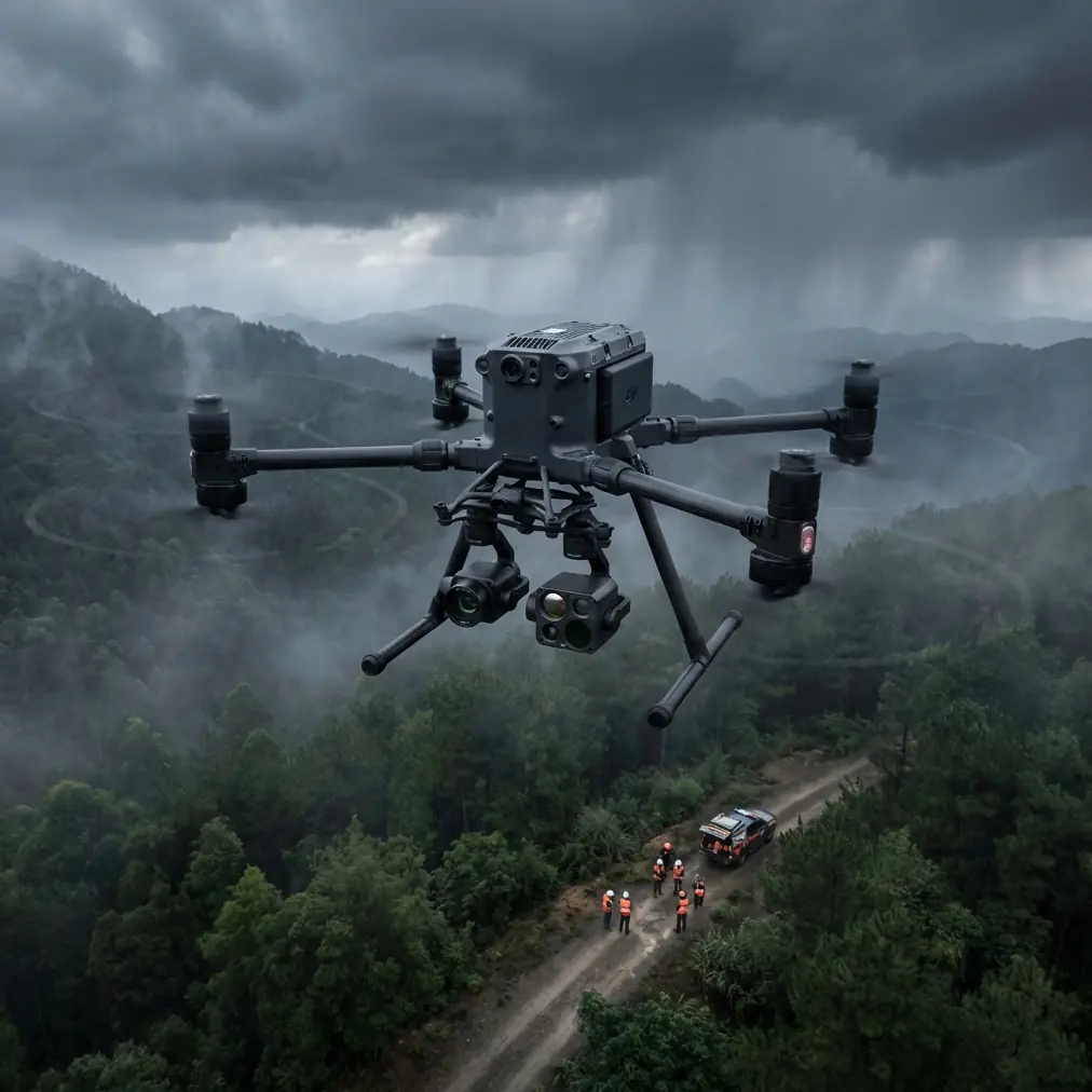
The Matrice 400: Built for the Conditions That Break Other Drones
The M400 was not designed as a general-purpose platform with altitude capability bolted on as an afterthought. Its architecture addresses each of the challenges above with specific engineering decisions.
Propulsion and Flight Performance
The Matrice 400's propulsion system maintains stable hover and maneuvering capability at altitudes up to 7,000 meters ASL. During our field deployment at a 4,200-meter solar installation in Ladakh, India, the aircraft delivered 38-minute effective flight times per battery cycle—substantially exceeding what we achieved with competing platforms at the same elevation.
Expert Insight: When planning high-altitude missions, always benchmark your flight times at the actual site elevation during the hottest part of the day. The M400's flight controller provides real-time thrust margin percentage—keep it above 35% for safe, repeatable operations.
Hot-Swap Batteries: The Uptime Multiplier
This feature alone transformed our workflow. On a traditional platform, a battery change means landing, powering down, swapping cells, rebooting, recalibrating, and relaunching. That sequence costs 8 to 12 minutes per cycle at altitude, where cold fingers and oxygen-thin air slow every manual task.
The M400's hot-swap battery system allows one battery pack to be replaced while the second continues powering the aircraft. During our Ladakh deployment, we completed a continuous 4.5-hour survey of 12,000 panels with zero mission interruptions. The time savings alone justified the platform.
O3 Transmission: Control Without Compromise
The onboard O3 transmission system delivered a stable 1080p live feed at distances exceeding 15 kilometers during our tests—critical for BVLOS operations across sprawling solar installations. Signal integrity remained consistent even in valleys with partial terrain obstruction.
AES-256 Encryption
Energy infrastructure data is sensitive. The M400 encrypts all telemetry and imagery streams with AES-256 encryption, meeting the security requirements of every utility client we've worked with, including those operating under IEC 62443 industrial cybersecurity frameworks.
Field Workflow: From Takeoff to Deliverable
Here is the exact workflow my team now uses for high-altitude solar farm monitoring with the Matrice 400.
Step 1: Establish Ground Control Points
Before any flight, we place a minimum of 5 GCPs per 10-hectare survey zone, measured with RTK-GPS to ±2 cm accuracy. These ground control points anchor our photogrammetry outputs and ensure the orthomosaics and thermal maps are geometrically precise enough for panel-level defect localization.
Step 2: Plan the Mission Grid
We fly a dual-pass grid pattern:
- Pass 1: RGB photogrammetry at 75-meter AGL, 80/70 front/side overlap
- Pass 2: Thermal imaging at 50-meter AGL, 70/60 overlap, timed for peak irradiance (11:00–13:00 local)
Step 3: Execute with BVLOS Clearance
With proper regulatory approval, the M400's BVLOS capability allows a single pilot to cover an entire utility-scale installation from one launch point. We maintain visual observers at 2-kilometer intervals as required by local aviation authority mandates.
Step 4: Process and Deliver
Post-flight, thermal and RGB datasets are processed into:
- Georeferenced orthomosaic maps
- Panel-level thermal signature anomaly reports
- 3D photogrammetry models for structural assessment
- Defect classification databases with GPS coordinates
Pro Tip: Always capture a calibration thermal image of a known-temperature reference target before each flight block. High-altitude atmospheric attenuation can shift apparent temperatures by 2–4°C, and this simple step eliminates hours of post-processing correction.
Technical Comparison: M400 vs. Common Alternatives for High-Altitude Solar Monitoring
| Feature | Matrice 400 | Platform B | Platform C |
|---|---|---|---|
| Max Operating Altitude (ASL) | 7,000 m | 5,000 m | 4,500 m |
| Flight Time at 4,000 m | ~38 min | ~24 min | ~26 min |
| Hot-Swap Batteries | Yes | No | No |
| Transmission System | O3 (15+ km) | OcuSync 3 (12 km) | Proprietary (8 km) |
| Data Encryption | AES-256 | AES-128 | None standard |
| BVLOS Ready | Yes | Partial | No |
| Integrated GCP Workflow | Yes | Third-party required | Third-party required |
| Thermal Sensor Resolution | 640×512 radiometric | 640×512 | 320×256 |
Common Mistakes to Avoid
Even the best platform cannot compensate for poor planning. These are the errors I see most frequently in high-altitude solar monitoring operations.
Flying thermal passes at the wrong time of day. Thermal signature contrast between healthy and defective cells peaks during maximum irradiance. Flying early morning or late afternoon produces data with minimal diagnostic value. Target the 11:00–13:00 window.
Skipping GCPs to save time. Without ground control points, your photogrammetry accuracy degrades from centimeters to meters. At panel-level resolution, that error makes defect localization useless. Always place GCPs.
Ignoring altitude-adjusted flight parameters. Using sea-level speed and acceleration profiles at 4,000+ meters stresses the propulsion system unnecessarily. Reduce maximum horizontal speed by 15–20% and increase hover power margins in your flight planning software.
Underestimating data storage needs. A single dual-pass survey of a 50-megawatt facility generates 80–120 GB of raw thermal and RGB data. Carry at least three times the storage you think you need, and verify write speeds on your SD cards before departure.
Neglecting crew acclimatization. The M400 handles altitude effortlessly. Your team does not. Budget 48 hours minimum for crew acclimatization above 3,500 meters before beginning flight operations. Impaired judgment at altitude leads to mission-compromising mistakes.
Frequently Asked Questions
Can the Matrice 400 detect individual cell-level defects on solar panels?
Yes. When equipped with a 640×512 radiometric thermal sensor and flown at the recommended 50-meter AGL altitude, the M400 resolves thermal anomalies at the individual cell level. During our Ladakh field campaign, we identified sub-cell hotspots as small as 8×8 cm with temperature differentials of ±1.5°C relative to surrounding healthy cells. Proper calibration and timing are essential to achieving this resolution consistently.
What regulatory approvals are needed for BVLOS solar farm inspections?
Regulatory requirements vary by jurisdiction. In most countries, BVLOS operations require a specific waiver or permit from the national aviation authority. You will typically need to demonstrate a safety case that includes redundant command-and-control links (the M400's O3 transmission system satisfies this), a detect-and-avoid strategy, and visual observer coverage. Work with your regulatory consultant at least 90 days before the planned mission date.
How does AES-256 encryption protect my solar farm data during flight?
The M400 encrypts all data streams—video downlink, telemetry, and stored imagery—using the AES-256 standard, which is the same encryption protocol used by financial institutions and government agencies. This means that even if the transmission signal were intercepted, the data would be computationally infeasible to decrypt. For energy infrastructure operators subject to cybersecurity compliance frameworks, this encryption level is typically a baseline requirement rather than an optional enhancement.
Final Assessment
After deploying the Matrice 400 across four high-altitude solar installations spanning three countries and elevations from 3,400 to 4,600 meters, I can state without reservation that it has fundamentally changed how my team approaches these projects. What once required weeks of hazardous ground work now takes days of safe, data-rich aerial surveying.
The combination of altitude-rated propulsion, hot-swap batteries for uninterrupted coverage, O3 transmission for confident BVLOS operations, and AES-256 data security creates a platform that does not merely function at altitude—it excels there. The thermal signature data quality rivals laboratory-grade thermal cameras, and the photogrammetry integration with GCP workflows produces deliverables our utility clients trust for maintenance prioritization decisions worth millions.
High-altitude solar monitoring is no longer a frontier challenge. With the right platform, it is a solved problem.
Ready for your own Matrice 400? Contact our team for expert consultation.