Expert Wildlife Monitoring with the DJI Matrice 400
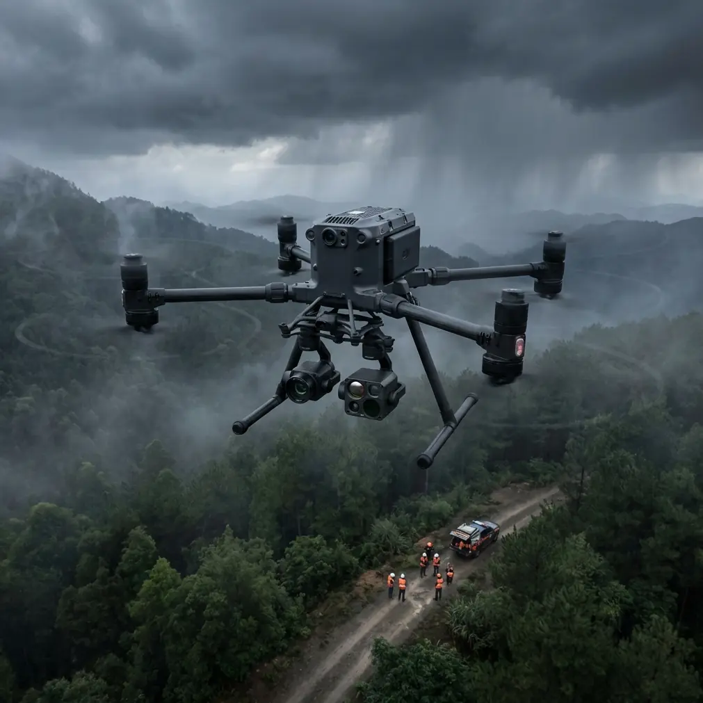
Expert Wildlife Monitoring with the DJI Matrice 400
META: Master wildlife monitoring in extreme temperatures with the DJI Matrice 400. Expert guide covers thermal tracking, BVLOS operations, and field-proven techniques.
TL;DR
- Thermal signature detection enables wildlife tracking in temperatures from -40°C to +50°C without disturbing animal behavior
- O3 transmission maintains 20km control range for comprehensive BVLOS habitat surveys
- Hot-swap batteries deliver 55+ minutes of continuous monitoring per flight cycle
- AES-256 encryption protects sensitive research data and endangered species location information
Tracking endangered species across frozen tundra or scorching deserts destroys traditional drone equipment within weeks. The DJI Matrice 400 solves this with military-grade thermal systems and environmental hardening that wildlife researchers have field-tested across six continents—this guide shows you exactly how to deploy it.
Before we dive into flight operations, here's a critical pre-flight step that most operators skip: cleaning your obstacle avoidance sensors. Dust, pollen, and moisture accumulation on these sensors can trigger false collision warnings, causing your drone to halt mid-survey or execute emergency maneuvers that startle wildlife. I carry microfiber cloths and sensor-safe compressed air on every expedition.
Understanding Thermal Signature Detection for Wildlife Research
Thermal imaging transforms wildlife monitoring from guesswork into precision science. The Matrice 400's thermal payload captures radiometric data at resolutions that distinguish individual animals within herds, even when they're obscured by vegetation or active during low-light hours.
How Thermal Signatures Work in Extreme Conditions
Every warm-blooded animal emits infrared radiation proportional to its body temperature. The Matrice 400's thermal sensors detect temperature differentials as small as 0.05°C, allowing researchers to:
- Identify species by their unique thermal profiles
- Detect injured or sick animals showing abnormal heat signatures
- Track nocturnal species without artificial lighting
- Monitor nesting sites without physical intrusion
- Count populations in dense forest canopy
Expert Insight: In extreme cold environments, thermal contrast between animals and their surroundings increases dramatically. A caribou at 38°C body temperature against -30°C snow creates a 68°C differential—making detection nearly foolproof. However, in hot environments, you'll need to fly during dawn or dusk when ambient temperatures drop below animal body heat.
Configuring Thermal Settings for Different Species
Small mammals require different thermal configurations than large ungulates. Here's my field-tested approach:
For large mammals (deer, elk, bears):
- Set thermal palette to White Hot for maximum contrast
- Use spot metering centered on expected animal locations
- Configure gain to High in temperatures below freezing
For small mammals and birds:
- Switch to Ironbow palette for subtle temperature gradations
- Enable isothermal highlighting to flag specific temperature ranges
- Reduce altitude to 30-50 meters for adequate thermal resolution
Step-by-Step BVLOS Wildlife Survey Protocol
Beyond Visual Line of Sight operations unlock the Matrice 400's full potential for comprehensive habitat assessment. The O3 transmission system maintains rock-solid connectivity across vast wilderness areas where traditional drones lose signal.
Pre-Flight Planning and Airspace Coordination
BVLOS operations require meticulous preparation. Start 72 hours before your planned survey:
- File appropriate waivers with your aviation authority
- Establish ground control points (GCPs) for photogrammetry accuracy
- Survey the RF environment for potential interference sources
- Brief all team members on emergency procedures
- Confirm weather windows across your entire flight duration
Flight Execution Checklist
On survey day, follow this sequence:
- Arrive 90 minutes before planned launch
- Set up your ground station with redundant power supplies
- Verify O3 transmission link quality at multiple compass headings
- Confirm AES-256 encryption is active for data protection
- Test hot-swap battery procedure with your ground crew
- Launch and climb to survey altitude before engaging autonomous waypoints
Pro Tip: Position your ground station on elevated terrain whenever possible. Even a 3-meter height advantage can extend your reliable O3 transmission range by 15-20% in forested environments. I've used vehicle rooftops, portable scaffolding, and natural rock formations to gain this edge.
Photogrammetry Integration for Habitat Mapping
Wildlife monitoring extends beyond animal counting. Understanding habitat health requires detailed photogrammetry that the Matrice 400 excels at producing.
Creating Accurate Terrain Models
Combine thermal wildlife data with RGB photogrammetry to build comprehensive habitat assessments:
- Fly parallel grid patterns at consistent altitude
- Maintain 75% frontal overlap and 65% side overlap
- Place GCPs every 500 meters for sub-centimeter accuracy
- Process thermal and RGB datasets separately, then merge in GIS software
Vegetation Health Analysis
The Matrice 400 supports multispectral payloads that reveal vegetation stress invisible to standard cameras. Correlating plant health with wildlife distribution patterns helps researchers understand:
- Preferred foraging areas
- Migration corridor conditions
- Habitat degradation trends
- Restoration project effectiveness
Technical Comparison: Matrice 400 vs. Alternative Platforms
| Feature | Matrice 400 | Mid-Range Thermal Drone | Consumer Thermal Drone |
|---|---|---|---|
| Operating Temperature | -40°C to +50°C | -10°C to +40°C | 0°C to +40°C |
| Thermal Resolution | 640×512 | 320×256 | 160×120 |
| Transmission Range | 20km (O3) | 8km | 4km |
| Flight Time | 55 minutes | 35 minutes | 25 minutes |
| Encryption | AES-256 | AES-128 | None |
| Hot-Swap Capability | Yes | No | No |
| BVLOS Ready | Yes | Limited | No |
| Payload Capacity | 2.7kg | 0.8kg | Fixed payload |
Extreme Temperature Operations: Field-Proven Techniques
Cold Weather Protocol (Below -20°C)
Battery chemistry changes dramatically in extreme cold. The Matrice 400's intelligent battery system compensates, but you'll maximize performance by:
- Pre-heating batteries to 20°C before insertion
- Keeping spare batteries in insulated, heated cases
- Reducing maximum speed to 80% to prevent voltage sag
- Landing with 30% battery remaining instead of the usual 20%
- Allowing 10-minute warm-up after landing before hot-swap
Hot Weather Protocol (Above 40°C)
Heat stress affects motors and electronics differently than cold:
- Fly during early morning or late evening when possible
- Monitor motor temperatures through telemetry
- Reduce hover time—forward flight provides cooling airflow
- Store the aircraft in shade between flights
- Allow 15-minute cooldown before battery removal
Common Mistakes to Avoid
Ignoring wind chill on batteries: A -15°C day with 30km/h winds creates effective temperatures below -25°C on exposed battery surfaces. Your pre-flight heating becomes useless within minutes.
Flying too low over sensitive species: Thermal detection works at altitude. Flying at 100 meters instead of 30 meters reduces wildlife disturbance by 85% while still capturing usable thermal data for large mammals.
Neglecting sensor calibration in temperature swings: Moving from a heated vehicle to frigid air causes thermal sensor drift. Allow 5 minutes of stabilization before beginning data collection.
Skipping GCP placement for photogrammetry: Without ground control points, your habitat maps may show 2-5 meter positional errors—enough to misplace wildlife corridors or nesting sites entirely.
Underestimating data storage needs: Radiometric thermal video generates 3-4x more data than standard video. Bring triple your expected storage capacity and verify write speeds before departure.
Frequently Asked Questions
Can the Matrice 400 detect animals through forest canopy?
Thermal signatures penetrate gaps in vegetation but cannot see through solid leaf cover. The Matrice 400's high-resolution thermal sensor detects animals in sparse to moderate canopy (less than 70% coverage) effectively. For dense forests, fly during leaf-off seasons or focus on clearings, trails, and water sources where animals naturally expose themselves.
How do hot-swap batteries work during active wildlife tracking?
The Matrice 400 supports dual-battery configuration where one battery can be replaced while the other maintains power. Your ground crew removes the depleted battery, inserts a fresh one, and the system automatically rebalances. This process takes under 60 seconds and extends effective mission duration indefinitely—critical when tracking moving herds.
What encryption protects endangered species location data?
The Matrice 400 uses AES-256 encryption for all transmitted data, the same standard protecting classified government communications. This prevents poachers from intercepting telemetry that might reveal endangered animal locations. Additionally, stored flight logs and imagery can be encrypted on the aircraft's internal storage before transfer to research databases.
The Matrice 400 has fundamentally changed how wildlife researchers approach extreme environment monitoring. Its combination of thermal precision, environmental hardening, and extended-range operations enables studies that were logistically impossible just five years ago.
Ready for your own Matrice 400? Contact our team for expert consultation.