Matrice 400 for Windy Coastline Scouting
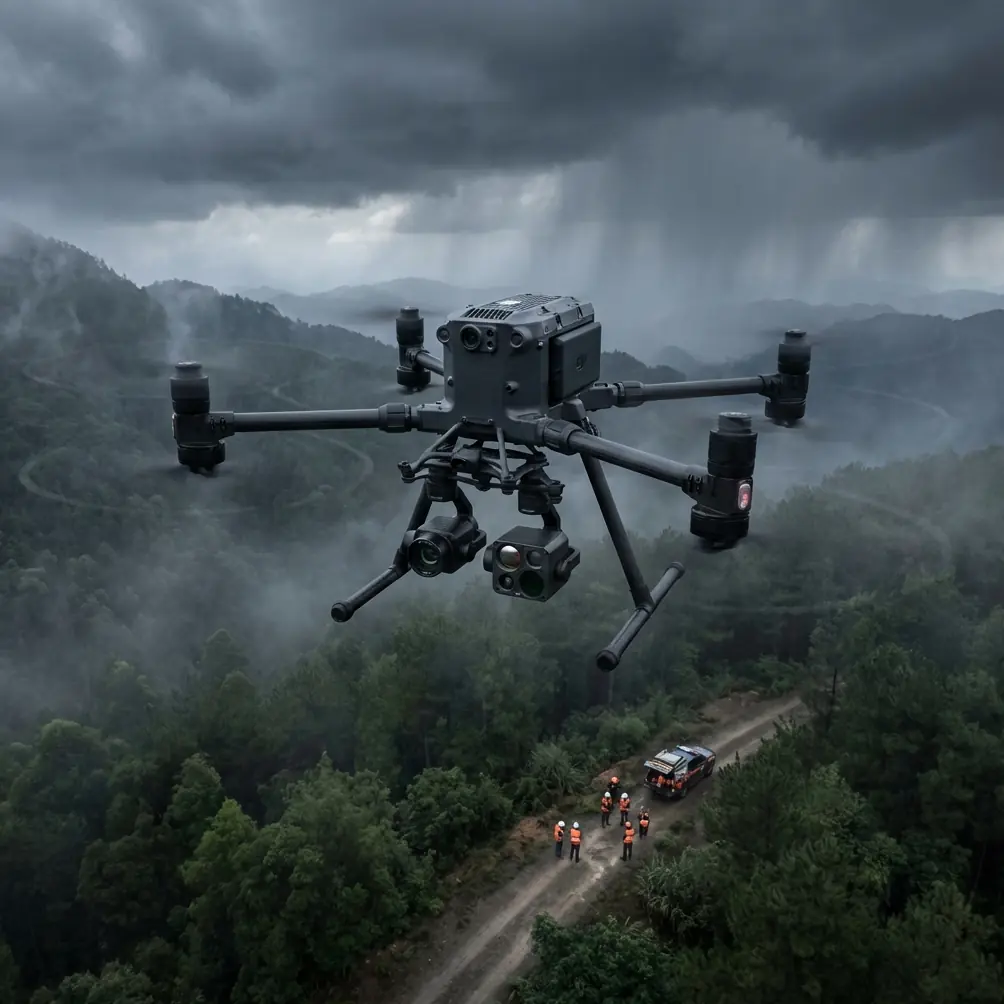
Matrice 400 for Windy Coastline Scouting: A Field Method Built Around Wiring Discipline, Signal Integrity, and Safer Data Capture
META: Expert how-to for using Matrice 400 on windy coastline missions, with practical flight altitude advice, payload signal considerations, EMI-aware setup, and inspection-focused workflow insights.
Coastline scouting looks simple from a distance. Wide open air, clear sight lines, long linear routes. In practice, it is one of the more punishing civilian flight environments for a large enterprise drone. Wind shear rolls off cliffs and dunes. Salt-laden moisture settles into every exposed surface. Signal conditions change as the aircraft tracks past towers, marinas, service roads, and reflective water.
That is exactly why the Matrice 400 deserves a more technical discussion than the usual platform summary.
If your job is shoreline inspection, erosion tracking, infrastructure checks, search planning support for civilian teams, habitat documentation, or pre-construction survey work, the aircraft is only one part of the answer. The real determinant of mission quality is how well the airframe, payload, wiring layout, signal paths, and flight profile work together under coastal stress. This is where an aerospace-style design mindset becomes useful.
I’m Dr. Lisa Wang, and if I were configuring a Matrice 400 program for windy coastline scouting, I would treat the mission as a signal management problem as much as a flying problem.
Why coastline work exposes weak system integration
Most operators think first about endurance, wind resistance, and camera choice. Fair enough. But on coastal jobs, the hidden failures often come from interference, harness stress, connector routing, and environmental loading on electrical systems.
One reference principle from aircraft electrical system design is especially relevant here: wire selection should account not just for voltage and current, but also humidity, temperature, mechanical strength, abrasion resistance, bending, pressure variation, pollution exposure, and special-use conditions. That is not abstract theory. It describes the coastline almost perfectly.
Salt moisture raises the stakes for every cable run between airframe, gimbal, sensor, radio link, and any ground accessories. Repeated setup and teardown at beach access points or rocky launch sites adds bending cycles. Long inspection days create heat accumulation inside protective routing and enclosed equipment cases. If you are running thermal payloads, photogrammetry sensors, RTK accessories, and communications links in the same workflow, you are asking a lot from the entire electrical chain.
The Matrice 400 can support advanced commercial operations, but only if the mission kit around it is built with the same seriousness as the aircraft.
The overlooked lesson from aircraft wiring manuals
A detail from traditional aircraft harness design matters here: sensitive lines should be separated, and audio or radio-related transmission lines are often bundled independently to reduce interference. Coaxial cables connected to radio and radar-type systems are also kept isolated, especially at higher frequencies.
For a Matrice 400 operator, the direct translation is simple. Do not treat every payload cable, antenna lead, extension, power accessory, or ground station add-on as interchangeable clutter.
If you are using O3 transmission, AES-256 protected data workflows, external monitoring, GNSS accessories, or shoreline sensors that generate low-level data signals, cable discipline affects more than neatness. It affects link reliability, data cleanliness, and troubleshooting speed.
In real missions, interference does not always look dramatic. Sometimes it shows up as:
- unstable live view near reflective water
- telemetry dropouts when repositioning antennas
- noisy thermal imagery metadata
- inconsistent mapping overlap because the pilot starts compensating for lag
- RTK or GCP reconciliation headaches later in processing
The older aerospace rule was to keep interference-sensitive circuits isolated from power wiring and avoid mixing unlike categories in the same connector path when special sensitivity is involved. That logic still holds. On a Matrice 400 coastline setup, keep RF-critical elements physically and logically separated from power distribution accessories whenever possible. If your team is building custom field packs, mobile charging stations, relay mast setups, or vehicle-based command layouts, this matters.
A practical altitude rule for windy coastlines
Let’s get to the question operators usually care about most: what altitude works best?
For windy coastline scouting with the Matrice 400, I usually recommend starting with a working band around 55 to 85 meters AGL for general visual inspection and situational scanning, then adjusting by objective.
That range is not arbitrary.
Below roughly 50 meters on many shorelines, the aircraft may spend more time fighting terrain-induced turbulence from seawalls, cliff edges, parked structures, and wave-driven upwash. Very low flight also narrows your situational awareness and increases the frequency of pitch and yaw corrections, which can reduce image consistency for mapping and thermal interpretation.
Above roughly 90 meters, you often gain smoother air, but you may begin losing the detail needed for fine-condition assessment of revetments, drainage outlets, rock armor displacement, fence damage, small cracks, or localized thermal anomalies. In shoreline photogrammetry, climbing too high can also dilute the ground sampling advantage you were trying to capture in the first place.
So the sweet spot for many civilian coastline missions is this:
- 55 to 65 meters AGL for detailed infrastructure checks, moderate wind, and tighter visual interpretation
- 65 to 85 meters AGL for broader erosion review, route familiarization, and efficient initial sweeps in gusty conditions
- lower only when a specific asset demands it and obstacle patterns are fully understood
- higher only when terrain relief, BVLOS corridor planning, or broader contextual capture outweighs fine detail needs
If you are using photogrammetry, lock altitude to the mapping deliverable, not pilot comfort. If you are using thermal signature analysis, remember that altitude influences both target pixel size and the way wind can mask subtle heat patterns across wet surfaces.
How to configure the Matrice 400 mission for coastal success
1. Build the payload plan around the task, not around convenience
Coastline scouting often bundles too many objectives into one sortie. A single flight tries to cover erosion, thermal screening, orthomosaic capture, and infrastructure inspection. That can work, but the payload stack and flight path need hierarchy.
Use visible imaging and photogrammetry first when the light and wind are most cooperative. Thermal work should be scheduled when surface contrast actually supports interpretation, not just because the sensor is available. If you are collecting GCP-based mapping data, design the route for overlap discipline before you worry about dramatic oblique shots.
The Matrice 400 becomes far more useful when each sortie has one dominant data product.
2. Respect harness routing and connector grouping
Aircraft design references note that harness planning should be coordinated early, and that grouping should support installation and maintenance. They also mention a practical harness diameter guideline: in general use, bundle diameter is often kept to no more than 50 mm for ease of installation and service.
The exact number is from a different aviation context, but the operational lesson transfers well. Large, messy, overstuffed field cable bundles are harder to inspect, harder to dry, harder to replace, and more likely to hide wear.
For Matrice 400 teams, that means:
- avoid overloading transport cases with tightly compressed cable loops
- separate RF, power, and data accessories in labeled paths
- inspect bends near connectors after every coastal deployment
- replace “still working” cables before corrosion and flex fatigue become intermittent faults
This is not glamour work, but it prevents the kind of mysterious field failures that get blamed on the drone.
3. Plan for moisture and contamination, not just rain
The reference material stresses environmental humidity and pollution when selecting wiring. Coastline operations deliver both even on dry days.
Salt mist is persistent. Fine grit gets into connector shells and cable sleeves. Launching from a vehicle tailgate beside the sea is not a controlled lab condition. Treat every return-to-base cycle as a contamination event. Wipe down interfaces. Dry before sealing gear into transport cases. Inspect antenna mounts and any accessory leads that were exposed during battery swaps.
Hot-swap batteries are valuable on long shoreline jobs, but speed should not replace inspection discipline. A fast turnaround only helps if the aircraft returns to the air with clean interfaces and stable electrical contact.
4. Use transmission strategy as part of route design
O3 transmission is not just a spec-sheet talking point. Along coastlines, the route itself should protect link quality. Water reflections, moving vehicles, metal guardrails, marina structures, utility corridors, and cliff shadowing all influence the quality of the control and video path.
That is why I prefer staging flights so the pilot and observers reposition proactively rather than trying to brute-force the route from one fixed launch point. On long linear missions, especially when BVLOS planning is involved under the relevant local approvals, transmission reliability is as much about geometry as radio capability.
If your operation needs a technical review of route shape, observation points, and payload integration, a direct message can sometimes save a full day of field trial and error: message the mission planning desk.
5. Use thermal carefully in wind
Thermal signature work on coastlines is tempting because it can reveal wet intrusion, drainage behavior, equipment heating, and habitat patterns. But coastal wind can flatten subtle temperature differences fast.
With the Matrice 400, thermal should be flown with a narrower objective:
- identify obvious anomalies
- compare repeatable targets over time
- confirm suspected defects from visual inspection
- avoid overclaiming weak patterns in highly ventilated, wet, reflective terrain
The aircraft can carry the sensor. The operator still has to respect thermal physics.
Mapping shorelines: when altitude, overlap, and GCP discipline matter more than speed
If your coastline mission includes photogrammetry, the Matrice 400’s value lies in consistency. Shoreline mapping is full of surfaces that confuse less disciplined missions: repeating wave edges, glossy tidal flats, low-texture sand, vegetation transitions, and uneven relief.
Three rules help.
First, fly a stable altitude matched to output requirements. Do not chase the terrain manually unless the route truly demands terrain following.
Second, increase overlap beyond your minimum comfort level when wind is active. Gust response changes image geometry more than many teams admit.
Third, use GCPs where legal and practical, especially if the shoreline product will support engineering, environmental reporting, or progress documentation. A drone flight can look excellent and still be weak where it counts: positional confidence.
Why fastener thinking also belongs in a drone program
At first glance, a standards reference on aircraft fasteners and a note about a 450°F stainless steel self-locking hex nut identified as MS21042 seems far removed from a Matrice 400 coastline mission. But it points to something operators overlook: vibration security and materials discipline are part of mission reliability.
No, you are not rebuilding the aircraft with aviation hardware. The lesson is broader. Coastal scouting combines vibration, transport shock, humidity, and repeated assembly cycles around mounts, brackets, tablet holders, antenna accessories, and vehicle-based support gear. If your supporting equipment uses low-grade hardware, it will loosen, corrode, or distort long before the drone itself becomes the limiting factor.
A professional Matrice 400 program should inspect not only airframe components but also:
- ground station brackets
- monitor mounts
- RTK base accessories
- vehicle charging racks
- field tables and launch fixtures
- payload case latches and hinges
The drone is rarely the only system in motion.
A sample windy-coastline workflow for Matrice 400 teams
Here is the field sequence I recommend.
Pre-deployment
Review wind by altitude, not just at ground level. Confirm launch and recovery surfaces. Pre-label payload and accessory cables by function. Check connectors for salt residue or abrasion. Verify data handling settings if your workflow requires AES-256 secured storage or transmission-related safeguards.
Initial sortie
Launch for a broad scan at 70 to 80 meters AGL. Use this pass to understand gust pattern, identify turbulence zones, and confirm route geometry. Avoid collecting your “final” dataset on the first pass.
Detail sorties
Drop to 55 to 65 meters AGL for asset-focused inspection or higher-detail orthographic capture. If cliffs, rock revetments, or structures create unstable low-level air, move laterally or slightly increase altitude rather than forcing the aircraft into the roughest band.
Thermal pass
Fly thermal only if the environmental window supports it. Keep the objective narrow and repeatable.
Turnaround
Use hot-swap battery capability efficiently, but treat every battery change as an inspection checkpoint. Look at prop condition, payload seating, cable strain points, and exposed interfaces before relaunch.
Post-flight
Separate wet and dry gear immediately. Review image consistency while still on site if possible. Do not wait until the office to discover that interference or turbulence degraded the mission.
What makes the Matrice 400 worth considering for this scenario
For windy coastline scouting, the Matrice 400 makes sense when you need one platform to support inspection, thermal review, and photogrammetry without constant compromise. But its real advantage appears only when the operator brings aircraft-level discipline to mission setup.
Two reference details summarize the point well.
One, wiring choices in aviation are shaped by humidity, abrasion, bending, contamination, and temperature because electrical reliability is environmental, not theoretical. That is exactly the problem a coastline creates.
Two, interference-sensitive and radio-related lines are separated into dedicated bundles because signal quality collapses when unlike systems are mixed carelessly. That logic applies directly to modern enterprise drone payload and transmission ecosystems.
The strongest Matrice 400 coastline teams will not be the ones with the most accessories. They will be the ones that keep the system clean, separated, inspectable, and mission-specific.
And when the wind comes up, that discipline shows in the data.
Ready for your own Matrice 400? Contact our team for expert consultation.