Matrice 400 for Urban Construction Scouting
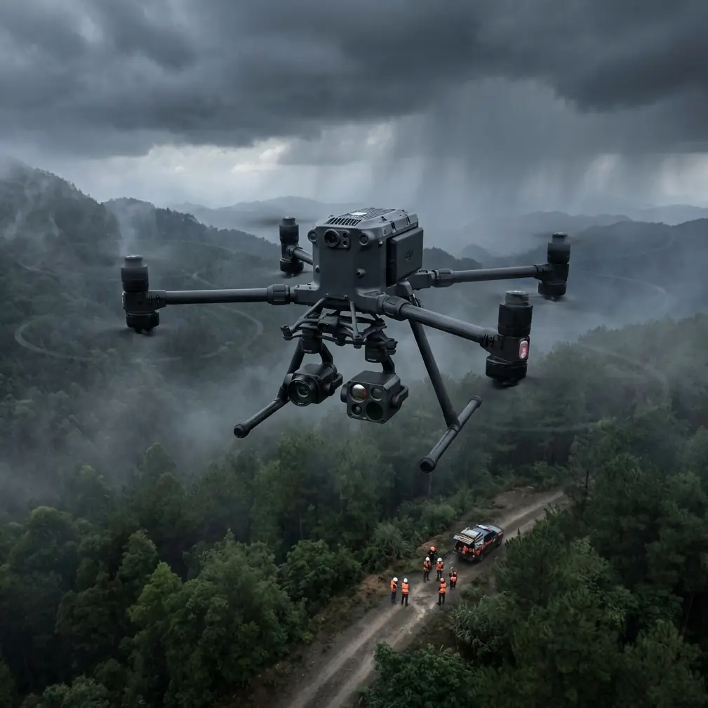
Matrice 400 for Urban Construction Scouting: What Actually Matters in the Field
META: Expert analysis of how the Matrice 400 fits urban construction scouting, with practical insight on battery management, photogrammetry, thermal signature work, O3 transmission, AES-256 security, and BVLOS planning.
Urban construction scouting looks simple from the sidewalk. Get the aircraft up, capture the site, come down, build a map, send the report. In reality, city work is where drone operations get exposed. RF noise is heavier. Flight paths are narrower. Tall structures interfere with line of sight, GNSS confidence, and pilot judgment. A mission that feels routine on an open site can turn fragile the moment you put cranes, glass facades, active traffic, and compressed job schedules around it.
That is exactly why the Matrice 400 conversation matters for construction teams working in urban environments. Not because a larger enterprise platform automatically fixes bad planning. It does not. It matters because urban scouting is a systems problem, and aircraft capability only becomes valuable when it solves field bottlenecks: transmission stability between buildings, secure handling of sensitive project imagery, battery continuity during repeated short sorties, and payload flexibility when one mission needs both photogrammetry and thermal signature review.
The most useful way to think about the Matrice 400 is not as a flying camera. It is a site intelligence platform for jobs where access is constrained and time on site is expensive.
The real urban problem: one site, three different information needs
Construction managers rarely need “drone footage.” They need answers.
They may need a current orthomosaic for progress documentation, a façade pass for envelope review, and a thermal sweep to identify moisture intrusion, insulation gaps, or rooftop equipment anomalies. On another day, the same site may require stockpile measurement, crane proximity awareness, and a visual record of perimeter conditions before a delivery window.
That is where many flight programs break down. The aircraft may be capable, but the workflow is not. Teams either fly too many separate missions, swap equipment inefficiently, or push batteries too far because they are trying to squeeze one more pass into a crowded schedule. The result is not just lost time. It is degraded data quality.
For urban scouting, the Matrice 400 becomes relevant when you use its architecture to reduce those compromises. If your operation can support photogrammetry capture on one rotation and thermal signature assessment on the next without losing tempo, you are not just flying more. You are making better site decisions with less disruption.
O3 transmission is not a spec-sheet footnote in the city
One of the details that matters most in an urban environment is O3 transmission. On paper, transmission standards often get treated as background technology. In the field, they define how confidently a pilot can operate around signal clutter, partial obstructions, and complex site geometry.
Anyone who has flown downtown knows the pattern. You are not always losing signal because of distance. You are often fighting multipath interference, reflective surfaces, and partial masking from structures that interrupt the clean relationship between aircraft and controller. That is a different problem than simple range.
For a construction scout working along tower edges, over setback roofs, or across staggered building footprints, robust O3 transmission changes the quality of decision-making. You can hold framing with less hesitation. You spend less cognitive energy second-guessing the link. That matters when the aircraft is collecting overlap-sensitive imagery for photogrammetry, where sloppy spacing and erratic speed control can reduce reconstruction quality.
It also matters for safer repositioning. In urban missions, pilots often need to transition between vantage points rather than fly one continuous wide-open route. Stable transmission during those transitions keeps the operation deliberate instead of reactive.
No serious pilot should rely on link performance as a substitute for sound site planning. But on dense construction projects, O3 is one of those operational details that directly affects mission discipline.
AES-256 matters more when the site itself is sensitive
Another overlooked detail in construction scouting is data security. Many urban projects involve sensitive infrastructure, restricted-access developments, public-private partnerships, or pre-release architectural work. The drone is not only capturing progress imagery. It may also be recording internal layouts, rooftop systems, staging methods, or site vulnerabilities.
That makes AES-256 relevant in a way that goes beyond a checkbox. Secure transmission and protected data handling are part of professional risk management, especially when project owners, general contractors, consultants, and insurers all touch the final outputs.
The operational significance is straightforward. If your drone program handles thermal imagery of building systems, close visual passes of structural components, and georeferenced site maps, then your data has value beyond simple documentation. Security standards help protect that information during capture and transfer. For urban teams working under tight compliance expectations, that lowers friction with stakeholders and strengthens trust in the drone workflow.
This is one reason enterprise platforms hold their place on professional sites. They are not just stronger in the air. They are often better aligned with the governance demands around the mission.
Photogrammetry in the city requires discipline, not just sensor quality
Construction teams often overestimate how easy urban photogrammetry is. Buildings create sharp elevation shifts, repetitive textures, shadow bands, reflective surfaces, and partial occlusions. Even a capable aircraft will produce mediocre mapping if the flight design ignores those conditions.
The Matrice 400 fits urban photogrammetry best when operators treat data capture as a controlled survey process. That means consistent overlap, careful altitude choices relative to surrounding obstacles, and disciplined use of GCPs when the output needs to stand up against engineering or progress-tracking demands.
Ground control points still matter. On constrained sites, GNSS conditions can be less forgiving because of surrounding structures. A solid GCP workflow helps anchor the model and reduce drift where pure aerial positioning may struggle. If the goal is to compare weekly excavation edges, verify material staging, or check the alignment of ongoing work against design intent, accuracy discipline matters more than cinematic appeal.
That is where the Matrice 400 earns value for urban scouting: not by making the site simpler, but by giving a serious operator the stability, endurance, and payload support to capture quality data consistently under less-than-friendly conditions.
Thermal signature work changes how you scout a site
Urban construction scouting is not only about visible progress. Thermal signature analysis can reveal issues the eye will miss during a standard visual pass. Rooftop ponding impacts, insulation discontinuities, HVAC stress points, façade anomalies, and potential moisture pathways become easier to isolate when thermal data is folded into the scouting process.
On active jobs, this can improve the timing of interventions. Instead of waiting for a complaint, a failed inspection, or visible material deterioration, teams can flag early indicators and direct ground crews to the right area. Thermal does not replace hands-on inspection. It narrows the search and saves time.
This is especially useful in urban projects where physical access is a problem. Suspended decks, roof setbacks, parapet edges, and tight neighboring clearances all make manual inspection slower and more disruptive. A platform like the Matrice 400 becomes strategically useful because it supports the shift from broad visual scouting to targeted diagnostic review.
In practice, that means fewer blind spots and better coordination between site supervision, envelope specialists, and facilities teams.
The battery tip that saves missions
Here is the field lesson that matters more than most pilots admit: hot-swap batteries are only an advantage if your battery discipline is stricter than your mission tempo.
On urban construction sites, crews often launch for short, focused sorties. A perimeter update. A rooftop pass. A quick thermal check. Then another flight an hour later. The trap is assuming these are “easy” flights and getting casual about pack management. That is how uneven battery temperatures, mismatched charge histories, and sloppy rotation habits creep into the operation.
My practical rule is simple: pair batteries as permanent working sets for the day and track them like they are married. Do not split them up because one pack looks a little stronger on paper. Do not drop a cooler battery into a warm rotation without thinking about it. And after landing, give the aircraft a brief reset window before the next hot-swap if you have been flying aggressive stop-start urban profiles around structures.
Why? Because urban missions often involve more hovering, more braking, and more micro-adjustments than open-area survey work. That creates a different power draw pattern. A battery set that performs fine over a wide corridor route can behave differently when the aircraft is constantly repositioning near buildings and holding angles for inspection shots.
Hot-swap capability is a major productivity advantage. It keeps the mission moving. But the best crews use that convenience to preserve consistency, not to rush. If your battery rotation is clean, your decision-making stays cleaner too. You stop gambling on “one last pass” and start planning flights around stable performance.
That habit matters on projects where weather windows are short and site access is tightly scheduled.
BVLOS discussions are getting more relevant for larger site programs
Not every urban construction mission is a BVLOS mission, and many should not be. Still, BVLOS belongs in the strategic discussion for organizations managing large, distributed, or corridor-linked urban projects.
Why mention it here? Because the Matrice 400 sits in the class of aircraft that pushes operators to think beyond isolated flights. If a contractor, utility partner, or infrastructure team is coordinating inspections across multiple urban segments, the aircraft’s endurance, transmission reliability, and enterprise controls make it part of a broader operational model rather than a one-off jobsite tool.
The significance is planning. Teams that may eventually pursue BVLOS workflows should start by standardizing their current urban VLOS missions: battery logging, route repeatability, payload procedures, data security, and emergency decision trees. The aircraft does not create compliance. The workflow does. But using a platform aligned with advanced operational frameworks makes that progression more realistic.
Even for teams staying inside conventional line-of-sight operations, BVLOS-style discipline improves everyday urban scouting.
A better way to structure the mission
For most urban construction scouting with the Matrice 400, I recommend treating the site as three layers rather than one flight.
First, capture the broad geometry. This is your photogrammetry and general progress layer. Fly it cleanly, build the site record, and protect overlap quality.
Second, fly the exceptions. These are façade details, crane adjacency checks, roof penetrations, staging conflicts, or access bottlenecks that deserve closer visual attention.
Third, run the diagnostic layer if needed. That is where thermal signature work earns its keep, especially around roofs, mechanical systems, and envelope transitions.
This layered approach reduces the common mistake of trying to collect every type of data in a single, overcomplicated sortie. It also aligns well with hot-swap battery operations. Each battery cycle gets a defined objective instead of becoming an improvised blend of mapping, inspection, and problem-solving.
If your site teams are still treating drone flights as one-off ad hoc tasks, that is usually the first thing worth fixing.
Why the Matrice 400 fits urban scouting better than generic drone thinking
The reason the Matrice 400 stands out in this conversation is not hype. It is fit.
Urban construction work punishes weak operational design. You need stable transmission in difficult RF environments, which is where O3 becomes operationally meaningful. You need strong security posture for sensitive project data, which is where AES-256 has practical value. You need the flexibility to support both photogrammetry and thermal signature tasks without turning the day into a logistics mess. And you need hot-swap battery workflows that support repeatable sorties instead of encouraging rushed decisions.
That combination changes the drone from an imaging tool into an intelligence asset for the site.
If I were advising a construction team scouting dense urban projects with a Matrice 400, I would focus less on spectacle and more on repeatability. Build battery discipline. Use GCPs when the mapping output matters. Separate broad capture from exception capture. Treat transmission quality and data security as operational factors, not marketing features. Plan every launch around the actual question the site needs answered.
That is how the aircraft starts paying off in the real world.
If your team is refining an urban drone workflow and wants to compare notes from the field, you can message an operator directly here.
Ready for your own Matrice 400? Contact our team for expert consultation.