Matrice 400 for Mountain Construction Site Survey
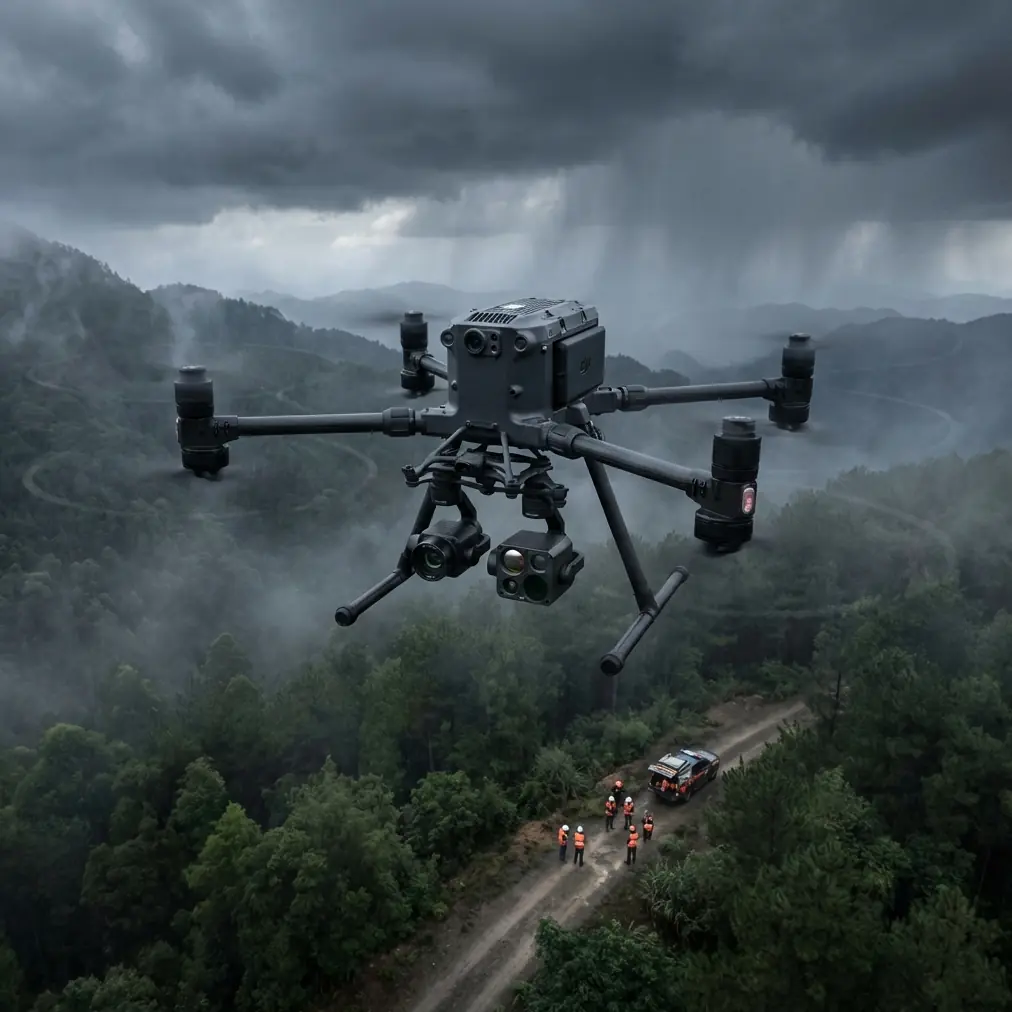
Matrice 400 for Mountain Construction Site Survey: What Actually Matters in Stereo Mapping Work
META: Expert review of Matrice 400 for mountain construction surveying, focused on photogrammetry, terrain reliability, imaging quality, and lessons from proven civil UAV mapping systems.
Mountain construction sites expose every weak assumption in a drone workflow.
Flat-ground habits stop working. Wind rolls over ridgelines. Launch zones shrink to awkward clearings. Signal paths get messy. And the real problem is not simply getting an aircraft into the air. It is collecting imagery that can stand up to engineering decisions later, when grade plans, cut-and-fill checks, drainage paths, and retaining structures depend on accurate terrain models.
That is why the most useful way to evaluate the Matrice 400 is not as another big-platform drone, but as the latest answer to a much older aerial mapping problem: how do you produce reliable, large-scale survey data in constrained areas without depending on airport-style logistics?
A 2009 civil UAV stereo mapping paper offers a surprisingly relevant framework here. The system described in Implementation and Application of Aerial Photographic System by Civil Unmanned Biplane for Survey and Stereo Mapping was built specifically for small-area, large-scale topographic mapping. Its designers did not obsess over abstract specs in isolation. They focused on a handful of parameters that still define whether a mission succeeds today: GSD, image point displacement, and base-height ratio. They also emphasized practical field traits that matter in rough terrain: low-altitude performance, autonomous flight, short takeoff and landing distance, operation without airport support, and a complete system architecture rather than a standalone airframe.
That old paper was centered on a civil biplane with a digital camera and a 3-axis stabilized gimbal. The Matrice 400 is obviously a very different machine. But the operational lesson transfers directly: for mountain construction work, platform design only matters if it improves image geometry, field deployment, and data confidence.
The real benchmark is not “can it fly the site?”
It is “can it hold mapping quality when the site is working against you?”
On steep construction corridors, especially road cuts, hydropower access routes, hillside foundations, and remote utility staging areas, photogrammetry fails for predictable reasons. Oblique terrain changes distort overlap. Wind increases motion-induced blur. Long, narrow sites tempt crews into poor line planning. Battery swaps interrupt consistent light windows. And teams under schedule pressure often underinvest in GCP layout because just reaching the ground control locations is exhausting.
This is where the 2009 stereo mapping study remains useful. It explicitly analyzed the rationality of GSD, image point displacement, and base-height ratio because those are the variables that determine whether the finished model is useful or merely attractive. In plain terms:
- GSD determines the detail level you can trust.
- Image point displacement affects how cleanly features are represented and matched.
- Base-height ratio influences stereo geometry and therefore elevation reconstruction quality.
That trio matters even more in mountain construction than on a level industrial estate. Poor base-height planning on broken terrain leads to weak vertical definition where contractors most need confidence: slope faces, excavation benches, drainage channels, spoil piles, and access roads cut into gradients.
The Matrice 400 should be judged through that lens. If it helps crews maintain stable, repeatable image capture over uneven ground, then it earns its place. If it simply offers more flight power without improving data discipline, then it is oversized convenience.
Why mountain jobs reward systems thinking
One detail from the reference stands out: the older mapping solution was not described as just an aircraft. It was built as seven subsystems, including the unmanned aircraft, autonomous flight control and safety, CCD digital camera, stabilized gimbal, air-ground wireless communications, ground station, and data processing.
That structure still reflects how serious site-survey operations work.
Construction managers often ask whether the drone itself is “good enough.” Survey teams know the better question is whether the whole chain is good enough. The Matrice 400 becomes valuable when it integrates into a disciplined mapping stack:
- aircraft stability in mountain wind
- dependable transmission, especially where ridges interrupt line-of-sight
- sensor payload consistency across repeated flights
- mission planning that respects terrain
- field control with properly placed GCPs
- secure data handling, especially on sensitive infrastructure jobs
- post-processing that preserves geometric integrity rather than cosmetically smoothing problems
This is where modern capabilities like O3 transmission, AES-256 data security, and hot-swap batteries are not side notes. They affect whether a site team can keep production moving without sacrificing survey quality.
O3 transmission matters because mountain sites are notorious for broken signal paths. Even when operations remain within legal and procedural limits, ridges, towers, and terrain folds can create frustrating drops in situational awareness. Stronger transmission resilience helps crews preserve flight continuity and camera confidence, especially during long corridor missions or when working from less-than-ideal ground positions.
AES-256 matters for a different reason. Many mountain construction projects sit inside critical infrastructure programs: transport links, utility corridors, water works, and industrial access networks. Security is not a marketing bullet here. It is part of project compliance. If imagery, thermal files, and terrain outputs are part of progress verification or contractor documentation, secure handling becomes operationally relevant.
Hot-swap batteries sound mundane until you have lost a clean light window because a battery change forced a full shutdown and restart cycle. On mountain jobs, where travel time to the launch point can be significant and weather windows can collapse quickly, minimizing workflow interruption has real value.
A lesson from older UAV mapping: stability is not a luxury
The 2009 paper specified a 3-axis stabilized gimbal and treated it as essential to direct digital aerial image capture. That remains exactly right.
Mountain jobs magnify every motion error. A platform can have excellent nominal camera specs and still produce weak mapping data if attitude changes are not controlled well enough during image acquisition. On a site with elevation variation, haul-road dust, crosswinds, and changing sun angle, image stability affects tie-point generation, reconstruction confidence, and edge definition.
With the Matrice 400, this becomes especially important if your mission is not limited to a standard nadir photogrammetry pass. Many mountain construction teams now combine:
- photogrammetry for topography and stockpile analysis
- thermal signature checks for drainage anomalies, moisture retention zones, or roof and utility inspections on temporary site structures
- visual progress capture for engineering review
- repeatable missions for change detection
A stable payload platform is what lets those data products coexist without turning each sortie into a compromise.
The part most teams still underestimate: takeoff and recovery constraints
Another detail from the reference deserves attention. The civil biplane system was valued for short takeoff and landing distance, good gliding performance, and operation without airport support.
The exact aircraft format is different, but the field logic is the same for the Matrice 400. Mountain construction sites rarely offer textbook staging conditions. You might be operating from a widened bend in an access road, a temporary laydown area, or a narrow bench carved into a slope. Sometimes the mission plan looks elegant in the office and awkward on the mountain because the launch point has changed after overnight blasting or rain.
That is why deployment flexibility matters more than spec-sheet vanity. A drone that can be fielded quickly, safely, and repeatedly from constrained locations will outperform a theoretically capable platform that slows the whole crew down.
I learned this the hard way on a steep infrastructure site where the survey objective itself was straightforward: regular terrain updates for progress measurement and revised earthwork estimates. The challenge was not flight planning on paper. The challenge was sustaining repeatable sorties when the site changed daily, vehicle traffic narrowed setup zones, and the best observation point for the pilot was never the same two days in a row. What made the newer generation of enterprise platforms easier was not one breakthrough feature. It was the reduction of operational friction. Faster setup. Better link stability. Fewer interruptions during battery changes. Cleaner integration between aircraft, payload, and mission planning.
That is the difference between owning a capable drone and maintaining a dependable survey routine.
Photogrammetry on slopes: where Matrice 400 can actually save time
For mountain construction work, time savings rarely come from flying faster. They come from avoiding rework.
If your image set has inconsistent overlap because terrain was not handled correctly, you pay later. If motion artifacts weaken reconstruction around retaining walls or cut faces, you pay later. If your GCP distribution is too sparse in vertical relief, you pay later.
The older stereo mapping paper was built around large-scale topographic output in small areas. That is still the right mindset for many mountain sites. A project may not cover enormous ground, yet the terrain complexity means the mapping burden is high. Precision matters over acreage.
Used well, the Matrice 400 can reduce repeat flights by supporting more disciplined terrain-following mission design, steadier imaging, and more efficient field cycles. But only if teams respect the fundamentals from the reference:
Target the right GSD for the engineering question.
Chasing ultra-fine resolution across an entire mountain site can be inefficient. Reserve denser capture for slope hazards, drainage structures, or critical foundation zones.Control image point displacement through stable acquisition.
Wind, speed, and attitude all affect image quality. Stable capture is not optional when the terrain itself is already increasing matching complexity.Plan base-height ratio for elevation fidelity, not convenience.
In steep terrain, lazy line spacing can weaken the 3D model exactly where grade changes matter most.Treat the mission as a system, not a flight.
Aircraft, gimbal, transmission, ground station, processing workflow, and GCP strategy all interact.
That last point is worth repeating because it is where experienced teams pull ahead.
BVLOS discussions are meaningless without data discipline
There is plenty of industry interest around BVLOS, especially for long corridor or remote construction applications. In mountain environments, the appeal is obvious. Distances are longer, access is slower, and some corridors are painful to survey from the ground.
But BVLOS talk is often disconnected from the thing that matters most to engineers: whether the resulting dataset is trustworthy.
Extending operational range does not fix weak image geometry. It does not compensate for poor GCP distribution. It does not rescue a mission flown in unstable conditions with inconsistent overlap. So when assessing the Matrice 400 for future-oriented workflows, range should be viewed as an enabler, not a substitute for survey rigor.
The best enterprise drone is still limited by the quality logic outlined back in 2009: imaging parameters and system integration determine whether a map can support decisions.
Thermal signature is useful, but only when tied to the site problem
The context around Matrice 400 often encourages multi-sensor thinking, and rightly so. On mountain construction sites, thermal signature data can add value in targeted scenarios: identifying water ingress paths, checking temporary electrical or mechanical infrastructure, or spotting unusual heat behavior in equipment staging zones and structures.
Still, thermal should not become a distraction from the primary survey task. If the objective is earthwork verification or terrain change monitoring, photogrammetry remains the backbone. Thermal becomes powerful when layered onto a known geometry, not when used as a novelty pass detached from the mapped site model.
What I would prioritize before choosing the workflow
If I were advising a team scouting Matrice 400 deployment for mountain construction, I would focus on five questions:
- Can the aircraft maintain image consistency in local wind and terrain-induced turbulence?
- Does the transmission and ground-control setup remain practical from imperfect field positions?
- Will hot-swap battery workflow preserve momentum across multi-sortie mapping days?
- Is your GCP and checkpoint plan realistic for a steep, changing site?
- Are you selecting photogrammetry settings based on required engineering outputs rather than habit?
If you can answer those well, the platform starts working for you rather than simply impressing in a demo.
And if you are working through a real mountain-site mapping plan, from GCP layout to payload selection and repeat-capture workflow, it can help to talk it through with someone who has dealt with these terrain constraints before. You can start that conversation here: message our UAV team on WhatsApp.
Final assessment
The smartest way to view the Matrice 400 for mountain construction is through the discipline of civil aerial mapping, not through generic drone enthusiasm.
The old stereo mapping research referenced a system designed for small-area, large-scale topographic mapping, built around autonomous flight, low-altitude operation, a 3-axis stabilized gimbal, and a complete seven-subsystem architecture. It also emphasized the operational relevance of GSD, image point displacement, and base-height ratio. Those are not historical footnotes. They are still the framework for deciding whether a modern enterprise platform will deliver usable results in the field.
For mountain projects, that means this: the Matrice 400 is most valuable when it reduces the friction of collecting survey-grade imagery under difficult site conditions. Stable capture, secure data handling, resilient transmission, efficient battery workflow, and thoughtful mission design all matter because mountain terrain punishes weak systems.
If your team treats it as a serious mapping platform rather than a flying camera, it can make recurring site survey work much easier. Not by changing the laws of photogrammetry, but by making it more practical to respect them day after day on difficult ground.
Ready for your own Matrice 400? Contact our team for expert consultation.