Matrice 400 Guide for Remote Construction Site Scouting
Matrice 400 Guide for Remote Construction Site Scouting: What Actually Matters Before You Launch
META: A practical Matrice 400 tutorial for remote construction site scouting, covering pre-flight cleaning, flight planning logic, redundancy thinking, thermal workflows, photogrammetry, and safer decision-making.
Remote construction scouting is rarely limited by camera specs alone. The bigger constraint is whether the aircraft, data link, workflow, and pilot decisions stay coherent when the site is far from roads, crews are waiting on answers, and a missed pass means losing half a day.
That is where a Matrice 400 setup needs to be judged like an aviation system, not just a drone with a good payload.
For this kind of work, I like to start with a habit most teams underestimate: a deliberate pre-flight cleaning step. Not cosmetic cleaning. Functional cleaning. Wipe the vision sensors, lens glass, thermal window, and downward sensing surfaces. Check battery contacts, payload mount interfaces, and cooling vents. If the aircraft has been riding in dust, cement powder, or damp air, this is not optional.
Why begin there? Because remote site scouting depends on the chain of small things working together. A construction survey mission may require photogrammetry on one leg, thermal signature review on another, and then a quick visual inspection of access roads or stockpiles before landing. If one sensor is obscured by dust, if one connector is contaminated, or if one warning is dismissed because the crew is in a hurry, the aircraft may still fly, but the mission quality drops fast. In the field, “good enough” often becomes missing overlap, bad thermal contrast, false obstacle cues, or unnecessary re-flights.
That mindset aligns with a long-standing principle from manned aircraft system design: warning information must be clear enough for the crew to recognize an unsafe condition and take the right corrective action, while the system itself should be designed to minimize crew mistakes. For drone operators, that translates into a simple rule. Clean first, confirm status second, and only then trust the automation.
Why this matters more on remote construction jobs
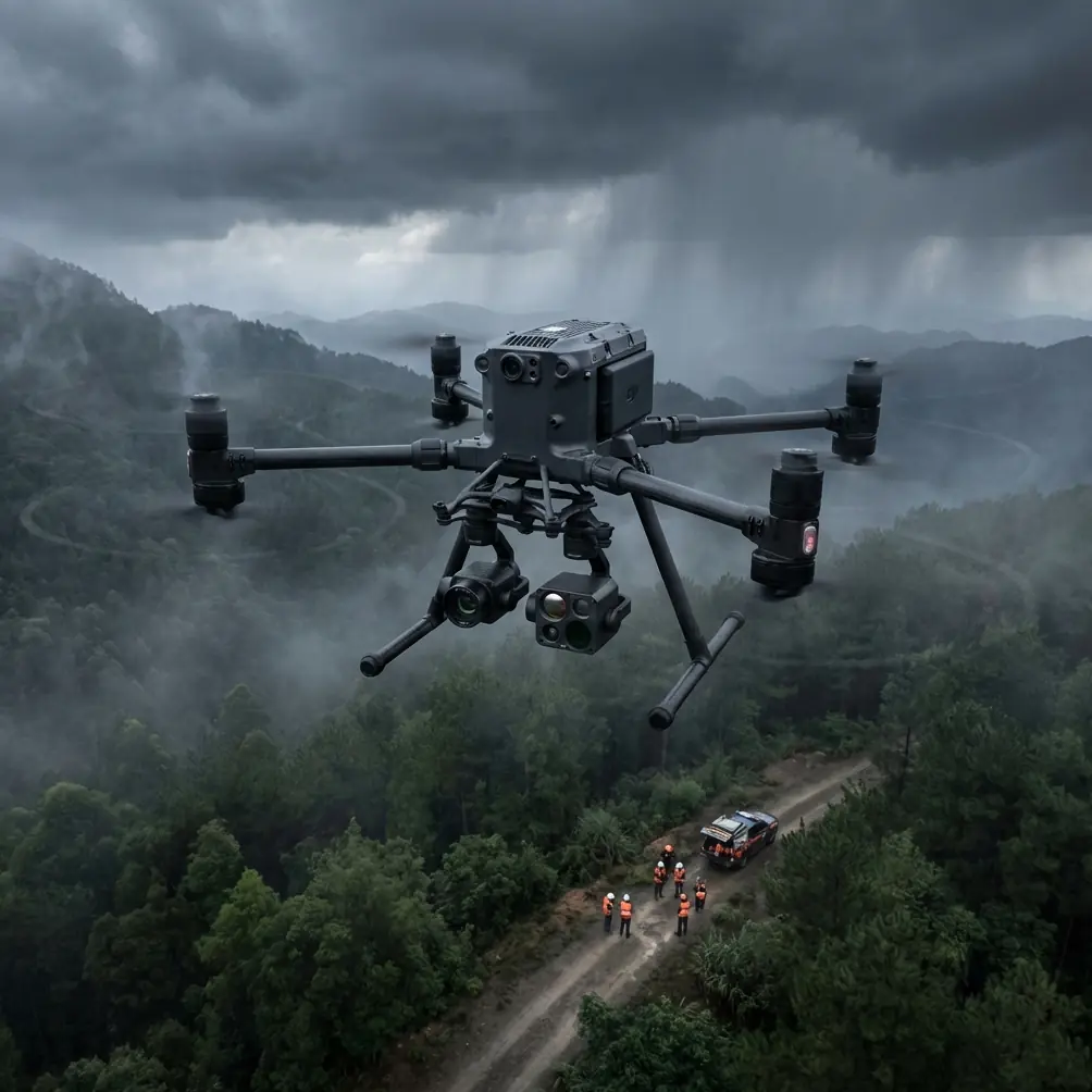
Scouting a remote site is a layered task. You may be checking haul roads, grading progress, drainage paths, crane laydown zones, perimeter security, material staging, and heat anomalies from equipment or temporary power systems. That means your Matrice 400 isn’t just collecting images. It is supporting site decisions that affect labor, logistics, and safety.
A smart workflow has to combine:
- reliable transmission over distance
- stable navigation
- accurate height and speed control
- payload clarity
- consistent power planning
- manageable pilot workload
Those same fundamentals appear in conventional flight management logic. One source document describes a flight management computer system that calculates display and control parameters, computes the flight profile, and supports full-profile guidance across climb, cruise, hold, and descent. That may sound far removed from a construction drone, but the operational lesson is direct: the best aircraft systems are not reacting randomly in the air. They are continuously integrating route, altitude, speed, and performance constraints into one guided profile.
For a Matrice 400 crew scouting a remote site, this matters when you build repeatable missions. Your route should not be just a rough polygon and a hope for the best. It should have a logic:
- ingress route to the work zone
- altitude selected for terrain, obstructions, and image scale
- speed matched to sensor objective
- action points for thermal, zoom, or oblique capture
- reserve power for a revised return path
That is drone mission planning at a professional level.
The pre-flight cleaning step I insist on
Before each site sortie, I recommend a four-minute cleaning and verification routine:
1. Clean optical and thermal surfaces
Dust on a wide camera lens can soften detail across an entire mapping block. Smudges on a thermal sensor window can distort apparent hot spots and cool zones. On a site where you are checking transformer pads, temporary generators, asphalt areas, or mechanical equipment, poor thermal interpretation can send the team in the wrong direction.
2. Clear obstacle sensing surfaces
Remote construction sites are full of airborne grit, concrete dust, and muddy spray. If obstacle sensing surfaces are dirty, the aircraft may become more hesitant than expected or less reliable around scaffolding, conveyors, or temporary structures.
3. Inspect battery and power contacts
Aviation reliability guidance puts strong emphasis on essential loads remaining powered not only in normal conditions, but after failures in a power source, converter, or distribution path. In drone terms, that means your power system deserves more respect than a quick glance at battery percentage. Inspect the contacts, locking state, and battery health indicators. If your Matrice 400 uses hot-swap batteries in your workflow, confirm both packs are seated, matched in condition, and free from contamination before you rely on rapid turnaround procedures.
4. Verify warning and status logic
Do not just clear warnings. Read them. The same helicopter design reference stresses that crews need warning cues that help them detect faults and take corrective action, and that analysis should consider failure modes, multiple failures, and the crew’s ability to recognize and respond. For a drone team, this means checking sensor status, IMU health, compass state, RTK or GCP workflow readiness, payload recognition, storage capacity, and return-to-home behavior before takeoff.
That is a lot of value from one short cleaning routine. It reduces pilot error, not just hardware error.
Build your route like a flight profile, not a casual orbit
One detail from the flight management reference stands out: vertical navigation calculations rely on signals such as barometric altitude, calibrated airspeed or Mach, vertical speed, and track distance. A Matrice 400 is not a jet, but the principle is universal. Vertical control is meaningful only when it is tied to where you are on the route and what the aircraft is trying to accomplish.
For construction scouting, that translates into mission design with altitude discipline.
If you are running photogrammetry, altitude drives ground sampling distance and overlap consistency. If you are checking embankments or cut slopes visually, altitude affects perspective and shadow reading. If you are doing thermal sweeps near active equipment, altitude changes the interpretability of the thermal signature and the amount of environmental interference.
The mistake I see often is treating altitude as static and speed as flexible. In practice, the opposite is usually safer for data quality. Set a mission altitude based on deliverable requirements first. Then adjust speed to preserve image quality, shutter performance, thermal readability, and aircraft margin in wind.
That kind of structured thinking mirrors another useful point from the same source: the desired lateral path can be modified by selecting a heading or entering a route. Operationally, this is exactly how a Matrice 400 crew should handle a remote construction site. You want a planned route, but you also want controlled authority to alter the lateral track when the site reveals something unexpected—a washout, a blocked access road, standing water, or an unreported machine cluster.
A remote site rewards teams that can shift from planned mapping to directed inspection without losing situational control.
Photogrammetry, GCPs, and the reality of field accuracy
If your scouting mission includes mapping, photogrammetry is only as useful as the discipline behind it. On remote projects, the temptation is to trust the aircraft, collect the images, and sort out accuracy later. That works until someone compares your model against earthwork quantities or layout progress.
Ground control points still matter when the site requires dependable geospatial outputs. Even if the onboard positioning workflow is strong, GCPs give you a way to validate and tighten the project. More importantly, they expose procedural errors early. If your overlap degraded, if the route bent around an exclusion area, or if elevation consistency suffered over uneven ground, the control framework will tell you.
For a Matrice 400 operator, the practical sequence is straightforward:
- define the product first: quick reconnaissance map or measurement-grade deliverable
- decide whether GCPs are required or whether checkpoints alone are sufficient
- align altitude, overlap, and speed with that output
- keep site traffic and evolving work fronts in mind so your route doesn’t age out before completion
This is where remote construction scouting becomes less about “drone footage” and more about decision-ready site intelligence.
Thermal work is only useful when it is interpreted in context
Thermal payloads add real value on construction sites, but they are often oversold internally. Thermal does not magically reveal every issue. It helps when you are asking a focused question.
Examples that make sense in civilian construction workflows include:
- checking temporary electrical installations for unusual heat patterns
- reviewing generator or equipment operating conditions from a safe stand-off position
- identifying moisture-related differences in some building envelope or material contexts
- comparing disturbed and undisturbed ground behavior under certain environmental conditions
The key phrase is thermal signature, not just thermal image. A signature means the pattern has context: time of day, material type, ambient conditions, viewing angle, and operating state. If your sensor window is dirty or your aircraft speed is too high for the scene, the reading becomes less trustworthy. That brings us back to the cleaning step and the route-speed-altitude relationship.
Transmission and data security are not side topics
On remote jobs, connectivity is part of safety and productivity. Strong O3 transmission performance matters because it affects more than pilot confidence. It shapes how well the crew can verify framing, react to site changes, and avoid unnecessary second passes. If the signal environment is poor or terrain is broken, your route planning should reflect that before launch rather than forcing the aircraft deeper into a degraded link area.
Data security also matters more than many field teams admit. Construction progress imagery can reveal scheduling, material staging, access patterns, and subcontractor activity. If you are moving site data through external devices or sharing outputs quickly from the field, encrypted handling is a sensible baseline. AES-256 support is not a marketing bullet in that environment; it is part of professional information control, especially for infrastructure, industrial, or utility-adjacent projects.
Failure thinking makes better drone crews
One of the most useful ideas in the helicopter reliability reference is that system evaluation should consider possible failure modes, including external causes, multiple failures, and failures that are not easily detected. That is a mature way to think about drone operations.
Apply it to a Matrice 400 mission over a remote construction site and you immediately improve your workflow:
- What if dust reduces sensor confidence without throwing a major alert?
- What if changing light conditions affect visual interpretation halfway through the route?
- What if a battery pair is technically flyable but operationally mismatched?
- What if your first path home is blocked by a crane swing, rising dust plume, or terrain masking?
- What if the aircraft can still fly, but not complete the original mission profile safely?
Crews that think this way are better prepared for BVLOS planning discussions too, because the discipline starts long before any regulatory conversation. It starts with route structure, warning interpretation, power margin, and conservative assumptions about what might degrade.
A sample remote-site workflow that works
For a typical Matrice 400 construction scouting mission, I would structure the sortie like this:
Stage 1: Site-edge verification
Launch from a clean, controlled area with good visibility. Hover-check status, payload feed, and obstacle sensing behavior.
Stage 2: High-level visual sweep
Run a broad pass to assess active zones, dust conditions, vehicle movement, and any temporary obstacles not visible in planning.
Stage 3: Mapping block
Fly the photogrammetry segment at fixed altitude and disciplined speed. If GCPs are in use, verify they remain visible and undisturbed.
Stage 4: Directed inspection
Use manual or semi-automated lateral path adjustments to inspect drainage lines, slope conditions, stockpiles, access roads, or structural progress.
Stage 5: Thermal review
Capture thermal data only after confirming the target question. Heat anomalies without context waste time.
Stage 6: Recovery with reserve
Land with enough margin for a go-around or relocation if the first recovery area becomes unusable.
If you want to compare your own planned workflow against a remote-site checklist, you can message our field team here: https://wa.me/85255379740
What separates a useful Matrice 400 mission from a waste of flight time
It is not the aircraft alone. It is the quality of system thinking behind the mission.
The two reference points we pulled from aviation design are worth remembering. First, flight systems create value when they integrate route, vertical profile, speed, and performance into one coherent guide. Second, reliability comes from designing around warnings, essential loads, environmental stress, and the probability of hidden or multiple failures.
Those are not abstract engineering ideas. They map cleanly onto daily drone work.
For a remote construction crew using a Matrice 400, the operational meaning is plain:
- clean the aircraft before every sortie because contamination breaks trust in the sensors
- plan the route as a complete profile, not as disconnected waypoints
- treat power continuity and battery condition as mission-critical
- use thermal and photogrammetry with a defined purpose
- respect alerts and system cues as part of the workflow, not interruptions to it
That is how you get useful outputs from a remote site in one trip instead of three.
Ready for your own Matrice 400? Contact our team for expert consultation.