Matrice 400 for Coastal Construction Site Scouting
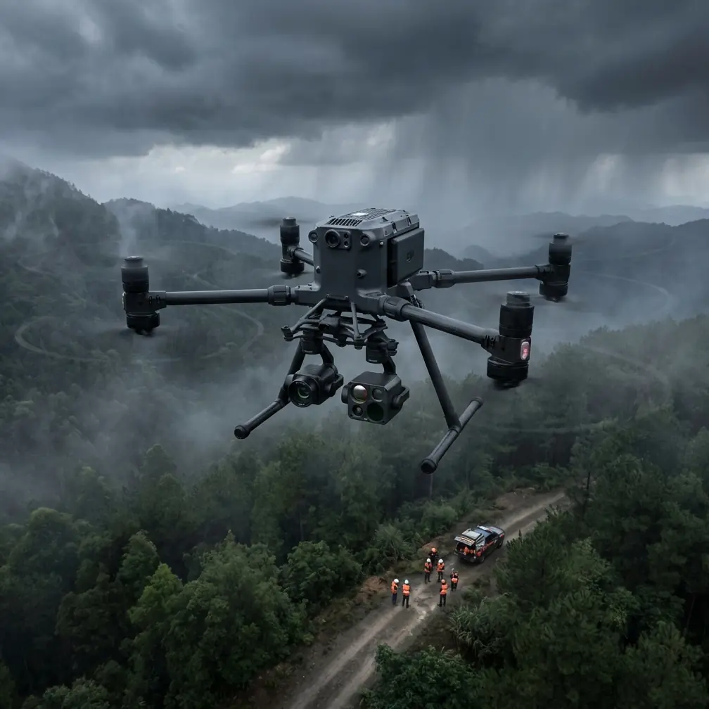
Matrice 400 for Coastal Construction Site Scouting: What Actually Matters in the Flight Profile
META: A technical review of Matrice 400 for coastal construction scouting, with expert insight on flight profiles, rotor limits, thermal workflows, transmission reliability, and why altitude transitions matter in real operations.
I’ve spent enough mornings on coastal construction sites to know that the hard part is rarely just “getting a drone in the air.” The hard part is getting repeatable, decision-grade data when the environment keeps changing under you: salt haze rolling in from the water, reflective surfaces confusing visual interpretation, wind gradients over unfinished structures, and crews waiting for answers that affect the day’s schedule.
That is the right lens for evaluating the Matrice 400.
Not as a spec-sheet trophy. As a working aircraft for scouting active coastal builds where you may need to move from perimeter reconnaissance to roofline inspection, then to thermal signature checks around electrical installations, and finish with a photogrammetry pass before the weather shifts again.
What makes the Matrice 400 interesting in this context is not one isolated feature. It is the way platform stability, mission planning logic, transmission reliability, and data security fit into a real flight profile.
The lesson most operators learn the expensive way
Years ago, on a coastal reclamation project, we were documenting drainage progress and temporary power routing near a partially erected concrete frame. The aircraft we were using was fine in straight, easy flight. It was less fine in the transitions that actually define construction scouting.
That’s where many missions get messy.
You launch, climb, reposition, slow down near a facade, yaw into the wind, descend for a thermal check, then accelerate back out to rebuild site context. In other words, you spend much of the mission in changing speed and changing attitude, not in a neat, steady-state line.
That’s why one detail from classical aircraft mission design still matters today. Traditional performance planning often breaks a mission into specific phases: takeoff and initial climb to 450 m, then climb to a higher cruise altitude, with a possible horizontal acceleration again at 3000 m if a higher beneficial climb speed becomes available as altitude increases. On descent, the same logic appears in reverse: use a lower descent speed below 3000 m, then level off to decelerate and prepare for approach, continuing down from cruise altitude toward 450 m before final arrival.
Those numbers come from manned-aircraft performance logic, but the operational principle translates directly to enterprise UAV work: transitions matter as much as the headline cruise segment.
For a platform like the Matrice 400, that means I’m less interested in how it behaves in a marketing-perfect hover and more interested in how it holds mission quality through repeated transitions—climb, accelerate, brake, descend, and stabilize again—while sensors continue producing usable data.
Why coastal construction exposes weak aircraft quickly
Coastal sites are aerodynamic troublemakers.
You have sea breeze interactions with cranes, partially enclosed structures, retaining walls, and temporary scaffolding. Wind over water can be smooth at one moment and badly disrupted near a building edge the next. This is exactly where rotorcraft behavior becomes operationally significant.
A core truth from helicopter aerodynamic design is that rotor systems are not simple. In forward flight, the advancing blade sees velocity added to its rotational speed, while the retreating blade sees it subtracted. At higher forward speeds, the aerodynamic environment gets progressively uglier: compressibility effects can appear on the advancing side, while stall and reverse-flow regions expand on the retreating side. The result is familiar to experienced operators even if they’ve never read a rotorcraft design handbook: more vibration, reduced control efficiency, and degraded performance when the aircraft is pushed into the wrong part of the envelope.
That matters for any multirotor working a coastal build.
The practical takeaway is not academic. It is this: when you are scouting construction sites, data quality depends on how conservatively and intelligently you manage transitions in turbulent air. If your route planning assumes the aircraft can sprint, brake, and pivot aggressively all day without penalty, your imagery and thermal interpretation will start to show the cost.
The Matrice 400 makes its strongest case when used by teams that understand this. Pairing a capable airframe with disciplined mission structure is what turns a difficult site into a manageable one.
A better way to fly the site
For construction scouting, I typically divide coastal missions into three distinct layers.
1. High-context overview pass
This is where you establish broad site awareness: shoreline edge conditions, stockpile locations, crane swing areas, temporary access roads, drainage channels, and material staging conflicts. For this layer, transmission stability matters more than operators sometimes admit. If your live view degrades or drops under interference, you start making micro-decisions late.
That’s where O3 transmission earns its place in the workflow. On a large site with steel, concrete, containers, and moving machinery, robust video and control links reduce the temptation to overfly closer than necessary just to maintain confidence. The result is a cleaner safety margin and better route discipline.
For coastal jobs that may eventually seek BVLOS-style workflow maturity, even if current operations remain within local visual rules, this kind of link reliability is not a luxury. It is part of the infrastructure of trust.
2. Targeted inspection layer
After the broad pass, the mission usually narrows. You are no longer asking, “What is happening on the site?” You are asking, “What exactly is happening on that surface, that conduit, that roof membrane, that retaining joint?”
This is where thermal signature work becomes especially useful. On coastal sites, thermal checks can help reveal moisture pathways, insulation irregularities, overloaded temporary electrical components, or heat anomalies around equipment housings. But thermal data is easy to misuse. Wind, wet surfaces, solar loading, and salt exposure all complicate interpretation.
The aircraft’s job is to hold stable positioning and predictable viewing geometry while the sensor does its work. The operator’s job is to avoid rushed transitions that contaminate comparison. If the Matrice 400 allows you to move from overview altitude into a lower, steadier inspection segment without excessive drift or control fuss, that directly improves confidence in the thermal read.
3. Measurement and reconstruction layer
Once the urgent visual questions are answered, the site often needs measurable output. That is where photogrammetry comes in.
On coastal construction projects, photogrammetry is valuable for tracking fill progress, grading changes, retaining-wall alignment, drainage geometry, and stockpile volumes. It becomes substantially better when tied to disciplined ground control. If the site can support GCP placement, the resulting model has a much better chance of serving engineering and coordination teams rather than just looking impressive in a viewer.
Again, flight profile matters. A mapping run flown after a chaotic inspection segment can inherit unnecessary variability. A professional workflow resets the aircraft and mission logic between tasks. Broadly speaking, that mirrors the old performance-planning mindset: distinct phases, each flown for its own purpose, instead of one blurred sortie trying to do everything at once.
Why transition performance is the hidden metric
The most overlooked sentence in old mission-performance literature is the idea that after gaining cruise altitude, an aircraft may still need a horizontal acceleration segment because climb speed and cruise speed are not the same thing. That sounds obvious, but many drone operators still build plans as if one speed suits every phase.
It doesn’t.
For Matrice 400 coastal scouting, a good mission often includes:
- a deliberate launch and climb segment,
- a stable transit segment,
- a controlled deceleration into observation,
- a low-speed inspection block,
- a reposition climb,
- then a separate mapping profile.
This is more than procedural neatness. It reduces blur, stabilizes thermal comparisons, protects geospatial consistency, and lowers pilot workload. Those are practical gains, not theoretical ones.
The older aircraft-design reference also notes that the takeoff and initial climb to 450 m are often treated as a short phase whose time and fuel impact are relatively modest compared with later segments. In drone terms, the equivalent insight is that teams often obsess over the launch itself while underestimating what happens after the first minute. The real mission risk usually appears later—during repeat transitions and prolonged exposure to disturbed air around structures.
That is where a mature platform distinguishes itself.
Endurance is only useful if the workflow supports it
People love talking about endurance, but endurance without process discipline just gives you more time to collect inconsistent data.
One of the more practical field features in this class is hot-swap batteries. On a coastal site, where weather windows can be narrow and travel between launch points is slow, hot-swap capability changes how a team schedules work. You can preserve continuity in the operation, rotate crews more efficiently, and avoid needless shutdowns between adjacent site sectors.
That matters most when the mission is layered. For example, you may complete your first pass of visual reconnaissance, bring the aircraft in, swap power, and resume with a dedicated thermal or photogrammetry sortie while keeping the broader operational setup intact. Less interruption usually means less human error.
It also supports a more honest division of tasks. Instead of trying to cram visual, thermal, and mapping objectives into one overly ambitious flight, the team can structure separate sorties with cleaner settings and better deliverables.
Data security is part of site professionalism now
On major construction projects, site data is no longer casual. You may be capturing utility routing, structural progress, subcontractor sequencing, or infrastructure details that owners do not want circulating beyond the project team.
That is why AES-256 matters in this conversation. Not because encryption is glamorous, but because enterprise UAV operations are increasingly judged by how they handle information, not just how they fly. A scouting mission over a coastal build can reveal schedule vulnerabilities, logistics bottlenecks, and installation details. Protecting transmission and stored operational data is now part of being taken seriously by sophisticated clients.
If a project manager asks whether your aerial workflow is secure, the answer should be specific and confident, not vague.
My bottom line on Matrice 400 for coastal scouting
The Matrice 400 makes sense when you evaluate it the way experienced aviators evaluate working aircraft: by mission phases, transition behavior, and data reliability under imperfect conditions.
For coastal construction sites, that means asking hard questions:
- Can the aircraft move cleanly from broad situational awareness to low-speed inspection?
- Can it hold enough stability for thermal interpretation around structures and utilities?
- Does the transmission link remain trustworthy when steel, concrete, and distance start stacking the odds against you?
- Can the operation support structured battery rotation and secure data handling without breaking workflow?
- Can the platform help your team separate inspection sorties from photogrammetry sorties instead of forcing one compromised flight plan?
Those are the questions that decide whether the output helps the superintendent, the QA team, the engineer, and the owner.
If you’re comparing deployment strategies for a coastal site and want to talk through mission design, transmission planning, or sensor workflow, you can message our field team here.
The deeper point is this: the Matrice 400 should not be judged as a generic drone. It should be judged as a mission platform for environments where rotorcraft complexity, altitude transitions, and data discipline all meet on the same day. Coastal construction is exactly that kind of environment.
And when the mission is built with those realities in mind, the platform starts to show its real value.
Ready for your own Matrice 400? Contact our team for expert consultation.