Matrice 400 Guide for Mountain Field Scouting: Range
Matrice 400 Guide for Mountain Field Scouting: Range, Reliability, and What Actually Matters
META: A practical Matrice 400 field-scouting tutorial for mountain terrain, covering antenna positioning, transmission reliability, thermal workflows, photogrammetry planning, and cockpit-inspired control design lessons.
Mountain field scouting is where drone spec sheets stop being abstract.
On paper, a platform like the Matrice 400 promises long reach, stable transmission, advanced payload flexibility, and serious automation. In the mountains, those claims get tested by sloped terrain, blocked sightlines, shifting wind, patchy GNSS geometry, and the simple fact that operators are often trying to collect useful data from awkward launch points. If your mission is scouting agricultural plots, utility corridors, terraces, forestry edges, or remote access tracks, the question is not whether the aircraft can fly. The question is whether the whole system stays dependable when the terrain works against it.
I want to frame this guide around two engineering ideas pulled from classic aircraft design references, because they map surprisingly well to real Matrice 400 operations.
The first comes from a section on imperial threads in Chapter 6 of an aircraft design handbook. At first glance, that sounds far removed from UAV fieldwork. It is not. Fastener standards are really about repeatability, fit, and avoiding small mechanical mismatches that become major failures under vibration.
The second comes from a helicopter design volume discussing hydraulic booster design. One passage is especially useful: the system design has to determine redundancy, feedback form, valve form, transmission ratio, maximum output force, maximum stroke, and maximum output speed, while also balancing stability, tracking behavior, impedance characteristics, and reliability. Another operational detail from the same source mentions a pilot pedal adjustment range of about ±50 mm to suit different body sizes. That is man-machine engineering in one sentence: a good system is not only powerful, it is usable without friction.
Those two details—thread discipline and human-centered control reliability—are exactly how I think about using the Matrice 400 for scouting fields in mountain terrain.
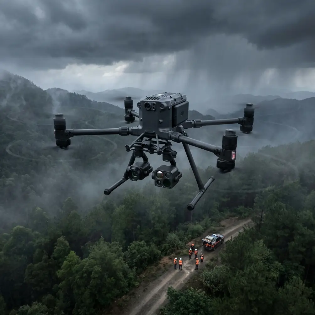
Why mountain scouting is a systems problem, not a camera problem
Most teams start with payload questions: Do we need thermal signature detection? RGB photogrammetry? Multispectral? Oblique capture? Those are valid. But mountain scouting usually breaks down earlier, in the chain between aircraft, operator, controller, terrain, and return logistics.
A clean thermal image is useless if ridge shadowing interrupts your O3 transmission. A neat photogrammetry block is worthless if your overlap collapses as the aircraft crosses elevation changes. A large-area scan becomes risky if battery changeover slows you down at a windy saddle launch site.
That is why the Matrice 400, in this context, should be judged as an integrated field platform. Transmission, ergonomics, battery handling, data security, and mission planning all matter at least as much as sensor resolution.
Start with antenna positioning, because mountain range is rarely a pure power issue
The fastest way to lose confidence in a mountain mission is to assume “maximum range” means the aircraft just needs more link budget. In practice, the limiting factor is often geometry.
Antenna positioning advice for maximum practical range
If you are scouting fields across stepped ridgelines or into folded valleys, keep these habits:
Elevate the controller position whenever possible
A launch point that is 10 to 20 meters higher than the nearby terrace edge can outperform a lower spot much closer to the target area. The reason is simple: terrain masking destroys consistency long before the aircraft reaches its nominal range.Aim for a broadside orientation, not a tip-pointing stance
Many operators instinctively point the antenna tips directly at the drone. For most controller antenna designs, that is the wrong geometry. You typically want the faces or broad radiation surfaces presented toward the aircraft’s general direction, preserving the strongest pattern rather than aiming the narrow tip.Avoid standing beside vehicles, railings, tanks, or sheet-metal sheds
In mountain agriculture and infrastructure sites, reflective clutter can produce link instability and false confidence. Your signal bars may look acceptable until the aircraft banks behind a contour line and the reflected path collapses.Reposition the operator before repositioning the mission
If O3 transmission quality degrades at a known section of the route, it is often better to move the ground station a short distance to restore line of sight than to force a compromised flight path. Ten careful steps uphill can save a battery cycle.Keep your body from becoming part of the RF problem
Operators with bulky packs, metal tripods, or a chest-mounted tablet bracket sometimes block part of the antenna pattern without realizing it. Turn your whole stance to the aircraft, not just your wrists.
This is the part that most mountain pilots learn only after frustration: maximum range is often an antenna placement and terrain visibility problem first, and a transmission technology problem second.
O3 transmission in mountain work: trust it, but don’t worship it
O3 transmission is valuable for scouting because it gives you the responsive video link needed to interpret terrain, crop stress boundaries, drainage lines, road cuts, and thermal anomalies in real time. But in mountain conditions, even strong digital transmission needs clean geometry.
Here is the operational significance: O3 helps reduce hesitation in the field. That matters when you are making micro-decisions—whether to extend a pass over an isolated plot, whether a hot spot is an irrigation leak or a sun-warmed rock face, whether a cliffside trail is clear enough for a follow-up inspection. But if you let the confidence of a modern downlink tempt you into flying with repeated ridge masking, you are no longer using the system intelligently.
The best Matrice 400 mountain crews treat transmission quality as a planning layer. They identify likely shadow zones before takeoff and build mission legs that preserve visibility through the longest critical segments.
Thermal signature work: use it for contrast, not magic
Thermal signature analysis in mountain fields can be extremely useful, but only if you respect terrain-driven false positives.
Early morning flights are often ideal because thermal separation is cleaner. Irrigation leaks, stressed vegetation, livestock pathways, water retention zones, and equipment heat sources stand out more consistently before solar loading smears the scene. On sloped land, however, exposed rock and uneven sun angles can mimic stress patterns. That is why thermal should rarely stand alone.
A practical Matrice 400 workflow is to pair thermal observations with a short RGB confirmation pass or a later photogrammetry run. In mountain scouting, interpretation improves when you combine:
- thermal anomaly location,
- slope aspect,
- visible crop pattern,
- and access route context.
This is where the aircraft’s stable platform and transmission reliability have real value. A thermal camera does not create operational truth on its own. The system gives you enough confidence to verify what you are seeing while still on site.
Photogrammetry in steep terrain: overlap has to follow elevation, not just map settings
Many field teams carry flatland habits into mountain mapping. That is a mistake.
If the Matrice 400 is collecting photogrammetry over terraced fields, hillside orchards, or mountain access tracks, your overlap settings need to account for elevation variation under the aircraft, not just the mission planner’s nominal altitude. In steep terrain, ground sample distance and side overlap can change faster than operators expect.
A better approach is to divide the area into terrain-aware blocks:
- upper terrace block,
- mid-slope block,
- lower drainage block,
- and any isolated benches or saddles.
If precision matters, bring in GCPs where they can be safely placed and clearly visible. You do not need excessive density for every scouting job, but a few well-positioned control points can anchor a model that would otherwise drift on repetitive terrain textures like rows, scrub, or rocky slope.
Operationally, this matters because mountain scouting is often not only about “seeing the field.” It is about measuring recoverable area, assessing erosion paths, checking access feasibility, or planning follow-up work. Good photogrammetry turns a visual survey into a planning asset.
Hot-swap batteries are not a luxury in the mountains
Teams often underestimate how much time and composure get lost during battery changes at exposed sites.
With hot-swap batteries, the Matrice 400 becomes far more usable in mountain scouting because you can sustain workflow continuity instead of rebuilding momentum after every landing cycle. In windy ridgeline operations or narrow launch areas, fewer full shutdown interruptions mean fewer chances for setup drift, controller reconnection delays, and rushed preflight habits.
The significance is not just convenience. It is mission rhythm.
When you are trying to capture a morning thermal window, finish a photogrammetry block before valley wind builds, or complete a recon leg before cloud shadow changes surface interpretation, hot-swap capability directly protects data quality.
AES-256 matters more when scouting creates sensitive land intelligence
Mountain field scouting often produces data that owners do not want casually exposed: crop condition patterns, water source locations, private access roads, infrastructure weaknesses, and seasonal usage behavior. If your Matrice 400 workflow includes AES-256 data protection, that is not a technical footnote. It is part of professional practice.
For contractors, co-ops, survey teams, and land managers, secure handling helps maintain trust when missions involve private holdings spread across remote terrain. It also matters when teams share preview imagery in the field, hand off storage devices, or transmit planning files among multiple operators.
A serious aircraft deserves equally serious data discipline.
What helicopter control design can teach Matrice 400 operators
The helicopter design reference is useful because it insists that performance and human factors are inseparable. The design section highlights parameters like maximum output force, maximum output stroke, and maximum output speed, but it also emphasizes stability, tracking, and reliability. That is exactly how mountain operators should evaluate their setup.
A drone that can move aggressively is not automatically better for scouting fields. In the mountains, the winning platform is the one that:
- tracks cleanly along contour-based routes,
- resists overcorrection in gusts,
- gives predictable response during camera adjustments,
- and keeps the pilot’s workload low.
That same reference also mentions adjustable controls with a range of about ±50 mm for different pilot body sizes. The drone equivalent is obvious: your controller, screen mount, strap arrangement, and hand position must fit the operator, not the other way around.
If your elbows are flared, your screen is too low, or your neck angle forces constant correction, your range and decision quality will degrade before your batteries do. Small ergonomic errors become strategic errors in mountain missions.
Don’t ignore mechanical discipline just because the aircraft is smart
The obscure aircraft handbook note on imperial thread standards in Chapter 6 might sound irrelevant to a Matrice 400 tutorial, but it carries a practical lesson: interfaces fail at the boring points.
Payload mounts, tripod adapters, field monitor brackets, controller rigging, antenna accessories, and transport-frame hardware should all be checked for proper fit and fastening discipline. Mixed thread assumptions, rushed field tightening, and vibration-loosened accessories create exactly the kind of preventable problem that can derail a long scouting day.
For mountain operators, this is especially significant because there is rarely a convenient second chance. If a monitor arm loosens at a remote launch point or a mounting plate shifts during a multi-battery survey sequence, the cost is not only hardware annoyance. It is lost weather window, lost confidence, and possibly incomplete data from a hard-to-reach site.
A practical Matrice 400 mountain scouting workflow
Here is the workflow I recommend to crews scouting fields in complex terrain:
1. Pick the launch site for visibility, not walking convenience
A slightly harder hike to a clean line-of-sight position usually pays off.
2. Set antenna geometry before powering into mission mode
Do a visual check: broadside orientation, no body blocking, minimal nearby reflective clutter.
3. Run a short transmission probe
Fly a brief leg toward the first terrain break and watch for signal behavior before committing to the full route.
4. Capture thermal first if the morning window is favorable
Use the cooler period for leak detection, plant stress clues, and drainage interpretation.
5. Follow with RGB or photogrammetry confirmation
Break the hillside into terrain-aware blocks and use GCPs where measurement quality matters.
6. Use hot-swap battery rhythm to maintain continuity
Land, change power, confirm mission state, and resume while environmental conditions are still comparable.
7. Secure and label data immediately
If multiple plots or landowners are involved, protect files and avoid confusing one block with another.
8. Debrief the link path, not just the imagery
Record where O3 performance dipped, where line of sight failed, and where antenna placement could improve the next mission.
If you want a field checklist adapted to your terrain and payload mix, you can message our UAV team here: https://wa.me/85255379740
The real standard for a Matrice 400 in mountain scouting
For this kind of work, the best aircraft is not the one with the loudest headline specification. It is the one that behaves like a mature aviation tool.
That means robust transmission supported by smart antenna positioning. It means thermal and photogrammetry used together, not in isolation. It means ergonomic setup that reduces pilot friction. It means battery changes that preserve tempo. It means secure data handling. And it means respecting the humble mechanical details—threads, mounts, fit, fastening—that keep a field system honest.
That is why the old aircraft design references still matter. One reminds us that reliability can begin at the fastener level. The other reminds us that control systems succeed only when stability, responsiveness, and human usability are designed together.
Applied to the Matrice 400, those lessons are not academic. They are the difference between a mountain scouting flight that merely looks advanced and one that consistently brings back data you can trust.
Ready for your own Matrice 400? Contact our team for expert consultation.