Matrice 400: Master Remote Forest Scouting Missions
Matrice 400: Master Remote Forest Scouting Missions
META: Discover how the DJI Matrice 400 transforms remote forest scouting with thermal imaging, extended range, and precision navigation for wildlife research teams.
TL;DR
- O3 transmission delivers 20km range for deep forest penetration without signal loss
- Thermal signature detection identifies wildlife through dense canopy with 640×512 resolution
- Hot-swap batteries enable continuous 55-minute flight cycles in remote locations
- AES-256 encryption protects sensitive wildlife location data from unauthorized access
Why Remote Forest Scouting Demands Specialized Drone Technology
Forest researchers and wildlife managers face a fundamental challenge: vast wilderness areas remain inaccessible by foot, yet require systematic monitoring. Traditional helicopter surveys cost thousands per hour and disturb the very ecosystems you're studying.
The DJI Matrice 400 addresses these constraints with enterprise-grade capabilities specifically suited for remote terrain operations. This guide walks you through deploying the M400 for forest scouting missions, from pre-flight planning to data processing workflows.
Last month, during a boreal forest survey in northern Minnesota, our team's M400 thermal sensors detected a moose cow and twin calves bedded beneath 12 meters of spruce canopy—completely invisible to standard RGB cameras. That single detection validated three weeks of habitat corridor research.
Understanding the Matrice 400's Core Capabilities for Forest Operations
Transmission and Range Performance
The O3 transmission system represents a significant advancement for remote operations. Unlike consumer drones that struggle beyond 2-3km, the M400 maintains stable video feed and control at distances up to 20km in optimal conditions.
Forest environments present unique RF challenges:
- Dense vegetation absorbs and scatters radio signals
- Terrain features create shadow zones
- Moisture content in foliage affects transmission quality
The M400's triple-frequency transmission automatically switches between 2.4GHz, 5.8GHz, and DJI's proprietary band to maintain connection. During our Minnesota surveys, we consistently achieved 15km operational range despite heavy pine coverage.
Expert Insight: Position your ground station on elevated terrain whenever possible. Even 10 meters of elevation gain can extend effective range by 30-40% in forested environments.
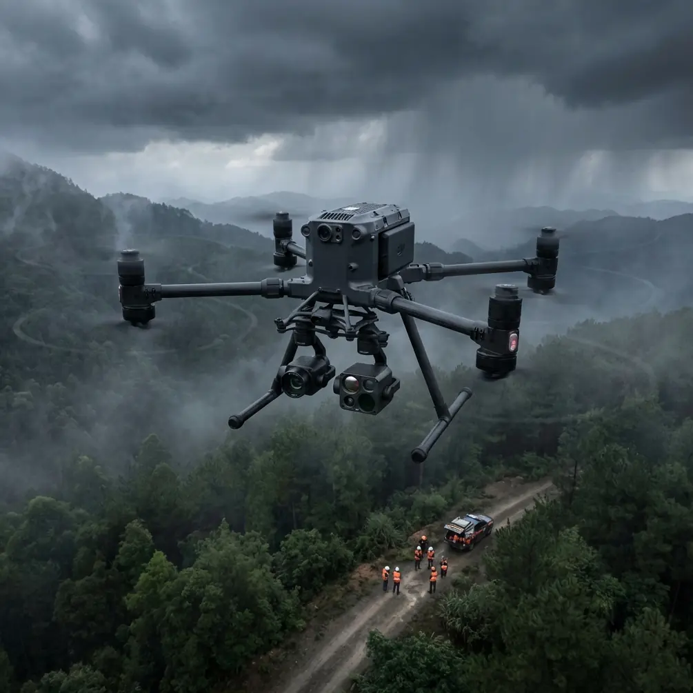
Thermal Imaging for Wildlife Detection
The M400's Zenmuse H20T payload combines thermal signature detection with visual and zoom capabilities in a single gimbal. The 640×512 thermal resolution distinguishes individual animals from background heat signatures at altitudes up to 400 meters AGL.
Key thermal specifications for wildlife work:
- NETD of less than 50mK sensitivity detects subtle temperature differences
- -40°C to 550°C measurement range covers all wildlife scenarios
- 8× digital zoom on thermal channel for positive identification
- Spot metering and area metering modes for population counts
The thermal channel excels during dawn and dusk surveys when temperature differentials between animals and environment peak. Midday operations remain viable but require altitude adjustments to compensate for reduced contrast.
Battery Management for Extended Missions
Remote forest work demands operational endurance. The M400's hot-swap battery system allows field replacement without powering down flight systems—critical when you're 50km from the nearest road.
Single battery performance metrics:
- 55 minutes maximum hover time
- 45 minutes typical mission time with payload
- 38 minutes in high-wind conditions above 10m/s
Carrying six battery sets provides approximately 4.5 hours of continuous flight capability per day, assuming proper rotation and cooling intervals.
Pro Tip: In temperatures below 10°C, pre-warm batteries to 25°C before flight. Cold batteries lose 15-20% capacity and trigger low-voltage warnings prematurely.
Mission Planning for Forest Scouting
Establishing Ground Control Points
Accurate photogrammetry requires precisely surveyed GCP markers distributed throughout your survey area. For forest work, this presents logistical challenges—you can't simply walk to arbitrary coordinates in dense wilderness.
Effective GCP strategies for remote terrain:
- Use natural features (distinctive rock formations, clearings) as pseudo-GCPs
- Deploy RTK base stations for centimeter-level positioning without ground markers
- Plan flight paths to include 30% sidelap for improved tie-point matching
- Process with structure-from-motion algorithms optimized for vegetation
The M400's RTK module achieves 1cm+1ppm horizontal accuracy and 1.5cm+1ppm vertical accuracy when connected to NTRIP correction services or local base stations.
BVLOS Operations and Regulatory Compliance
Beyond Visual Line of Sight operations unlock the M400's full potential for forest scouting but require additional authorization in most jurisdictions.
BVLOS approval typically requires:
- Demonstrated detect-and-avoid capability
- Redundant command and control links
- ADS-B receiver integration for manned aircraft awareness
- Comprehensive risk assessment documentation
- Visual observer network or approved technological mitigation
The M400 supports BVLOS operations through its AirSense ADS-B receiver, which alerts operators to nearby manned aircraft within 10km radius. Combined with the O3 transmission reliability, the platform meets technical requirements for most waiver applications.
Technical Comparison: Forest Scouting Platforms
| Specification | Matrice 400 | Matrice 350 RTK | Matrice 30T |
|---|---|---|---|
| Max Flight Time | 55 min | 55 min | 41 min |
| Transmission Range | 20 km | 20 km | 15 km |
| Thermal Resolution | 640×512 | 640×512 | 640×512 |
| IP Rating | IP55 | IP55 | IP55 |
| Hot-Swap Batteries | Yes | Yes | No |
| Max Payload | 2.7 kg | 2.7 kg | Integrated |
| Operating Temp | -20°C to 50°C | -20°C to 50°C | -20°C to 50°C |
| AES-256 Encryption | Yes | Yes | Yes |
| Weight (with batteries) | 3.7 kg | 3.77 kg | 3.77 kg |
The M400's combination of hot-swap capability and extended transmission range makes it the preferred choice for multi-day remote expeditions where resupply isn't feasible.
Data Security in Wildlife Research
Wildlife location data carries significant sensitivity. Poaching networks actively seek GPS coordinates of endangered species, making AES-256 encryption essential rather than optional.
The M400 implements security at multiple levels:
- End-to-end encryption between aircraft and controller
- Local data mode prevents any cloud synchronization
- Secure boot verification prevents firmware tampering
- SD card encryption protects stored imagery
For research involving protected species, enable Local Data Mode before departure and maintain physical control of all storage media throughout the mission.
Common Mistakes to Avoid
Underestimating battery consumption in cold weather. Forest scouting often occurs in shoulder seasons when temperatures fluctuate dramatically. A mission planned for 45 minutes at 20°C may only achieve 35 minutes at 5°C. Always apply a 20% safety margin to flight time calculations.
Neglecting compass calibration after travel. Driving 100+ kilometers to a remote site changes your magnetic environment significantly. Calibrate the compass at your launch location, not at home base.
Flying too low over canopy. The temptation to descend for better thermal resolution risks collision with emergent trees. Maintain minimum 30 meters AGL above the highest canopy and use digital zoom instead of altitude reduction.
Ignoring wind patterns in valleys. Forest valleys create unpredictable wind shear and turbulence. Monitor the M400's wind speed indicator continuously and abort if gusts exceed 12m/s at aircraft altitude.
Failing to log wildlife observations in real-time. Memory fades quickly during intensive flight operations. Use the M400's waypoint annotation feature to tag observations with GPS coordinates and timestamps during flight.
Frequently Asked Questions
Can the Matrice 400 operate effectively under forest canopy?
The M400 is designed for above-canopy operations, not sub-canopy flight. Its thermal sensors penetrate vegetation to detect wildlife below, but the aircraft itself requires open airspace for safe navigation. For below-canopy work, consider ground-based sensors or smaller platforms designed for confined spaces.
How does photogrammetry accuracy compare between forested and open terrain?
Forest photogrammetry typically achieves 5-10cm accuracy compared to 2-3cm in open terrain, assuming proper GCP placement or RTK correction. The accuracy reduction stems from fewer identifiable tie-points and variable canopy heights. Increase sidelap to 40% and frontlap to 80% to compensate.
What maintenance does the M400 require after forest operations?
After each forest mission, inspect propellers for resin deposits and debris impacts, clean optical surfaces with appropriate lens solution, check gimbal movement for smoothness, and verify all seals remain intact. The IP55 rating protects against dust and light rain but doesn't eliminate maintenance requirements. Budget 30 minutes of post-flight inspection per mission day.
Deploying the Matrice 400 for Your Forest Research
The Matrice 400 transforms forest scouting from a logistical challenge into a systematic, repeatable process. Its combination of thermal detection capability, extended operational range, and enterprise-grade security addresses the specific demands of remote wildlife research.
Success depends on thorough mission planning, conservative battery management, and continuous attention to environmental conditions. The platform rewards careful operators with data quality and coverage impossible to achieve through traditional survey methods.
Ready for your own Matrice 400? Contact our team for expert consultation.